
Oklahoma State Maps
Oklahoma State Maps – Detailed Printable Maps for Counties, Cities, Federal Areas, Physiographic & Ecoregions
Welcome to our comprehensive collection of Oklahoma State Maps, meticulously curated to provide detailed, high-resolution visualizations of the state’s geography, political boundaries, and natural regions. These maps are designed for students, researchers, planners, and anyone seeking an in-depth visual reference.
- Counties and Cities: Clearly defined county boundaries and major cities for planning, education, and demographic reference.
- Federal Areas: National parks, forests, monuments, wildlife refuges, military installations, and other federally managed lands.
- Physiographic Regions: Major landforms and terrain features such as mountains, plains, valleys, plateaus, and coastal areas.
- Ecoregions: Ecological zones representing forests, grasslands, deserts, wetlands, and other biodiversity regions.
Printable Map Profile
- Format: JPEG
- Color: RGB
- Resolution: ~72 DPI
- Typical image size: ~1300 × 1700 px
- Paper size: Letter (8.5 × 11 inches)
- Layouts: Portrait and Landscape
- File size: ~100–500 KB
Print tip: In your print dialog select Letter (8.5×11), choose Portrait or Landscape, and use Fit to Page (or Scale - to fit).
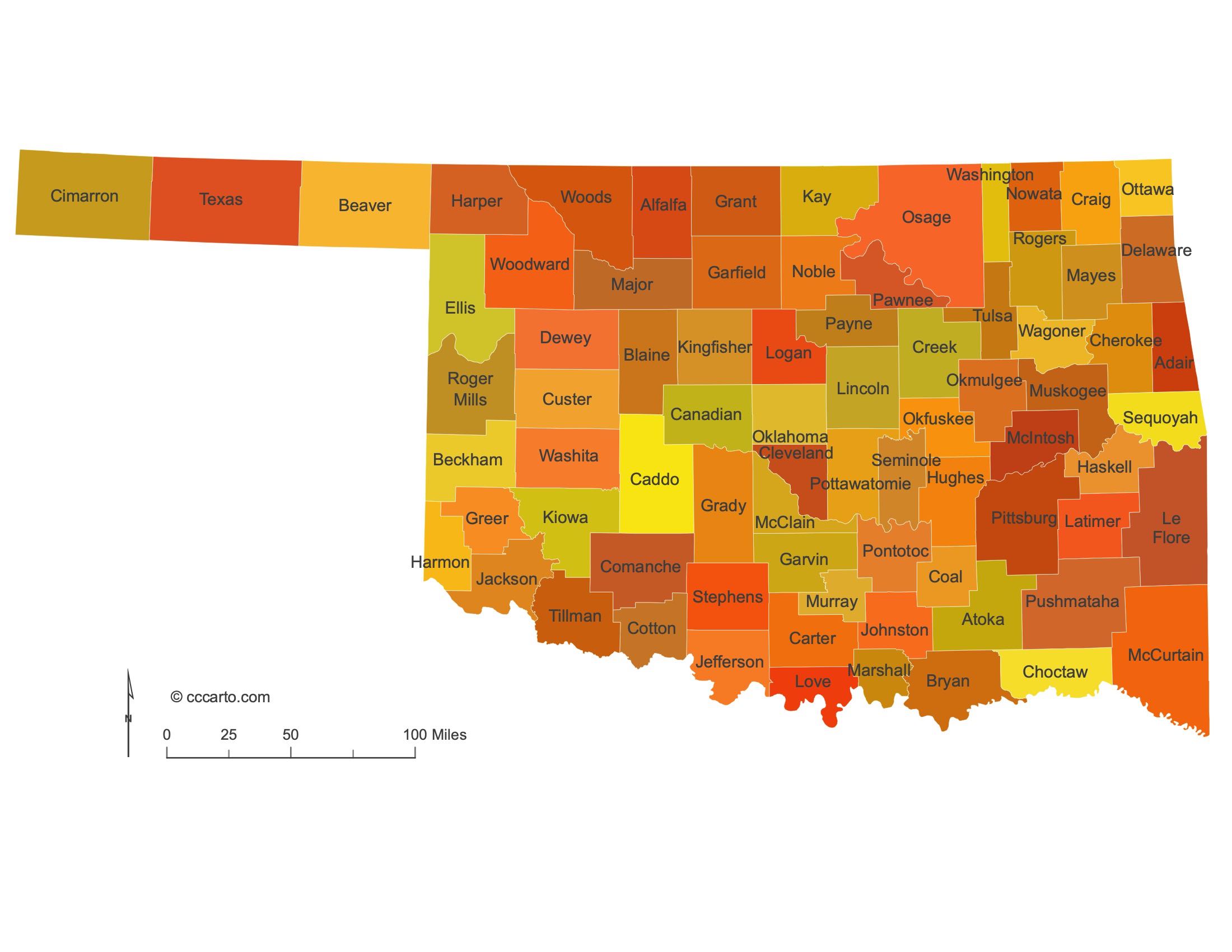
Oklahoma Counties
Oklahoma’s 77 counties span from the Red River to the high plains of the Panhandle; Oklahoma County and Tulsa County anchor most of the population, while far-western and southeastern counties remain rural.
- Number of counties: 77 — Oklahoma Historical Society
- First & last established: First territorial counties were created on (e.g., County No. 1 → Logan); the last new county was Cotton County (1912) — Newberry Atlas
- Highest & lowest county: Highest point: Black Mesa in Cimarron County (4,973 ft); Lowest point: Little River in McCurtain County (289 ft) — USGS
- Most & least populated county: Most: Oklahoma County; Least: Cimarron County
- Least & most developed (proxy by density/urbanization): Most: Oklahoma County (OKC metro); Least: Cimarron County (~1.2 people/mi²)
- Most geographically diverse county: Osage County (tallgrass prairie, Osage Hills/cross timbers, major reservoirs, rolling ranchlands) — see Tallgrass Prairie Preserve
- Strangest-shaped county: Cimarron County — the Panhandle’s west end; the only U.S. county touching four states (NM, CO, KS, TX)
- State’s Biggest Commodity: Cattle & calves — USDA NASS; ODAFF
- Largest Private Employer: Walmart
- Top 3 Non-English Languages: Spanish, Vietnamese, Other Native North American — DataUSA (ACS)

Oklahoma State County Sizes Map
Smallest County in Oklahoma State
County: Washington County – 420 sq miles
Largest County in Oklahoma State
County: Osage County – 2,315 sq miles
Mean and Median Area of Counties in Oklahoma State
Mean Area: Approximately 760 sq miles
Median Area: 621 sq miles

Major Cities of Oklahoma State and Their Locations
In Oklahoma State, most major cities are strategically located near rivers, oil fields, or historic transportation routes. Below are examples of each type:
1. Cities along Rivers
Tulsa: Located on the Arkansas River, Tulsa has a rich history linked to oil and transportation.
Oklahoma City: The capital, located near the North Canadian River, is an important economic and cultural hub in the state.
2. Cities near Oil Fields
Norman: Close to important oil reserves, Norman has become a key location for the energy industry.
Ardmore: This city is near the Healdton Oil Field, contributing to its growth during the oil boom.
3. Historic Routes
Lawton: Situated near the historic Fort Sill, Lawton has grown as a key military and economic hub in southwestern Oklahoma.
Enid: Positioned along historic cattle trails and railroads, Enid is known for its agricultural production and trade.

Topographic Tour of Oklahoma
Oklahoma State offers a range of terrains, shaped by its unique geology and natural features. From the prairies of the Great Plains to the forested regions of the Ouachita Mountains, Oklahoma’s landscape is diverse and varied.
1. Great Plains
The western part of the state, including the Panhandle, is part of the Great Plains. This area features flat to gently rolling terrain, with vast expanses of grasslands, making it ideal for agriculture and cattle ranching.
2. Osage Plains
The north-central region of Oklahoma is part of the Osage Plains, known for its open prairies and oak savannahs. The region is rich in oil reserves and agriculture, contributing to its economic importance.
3. Ouachita Mountains
Located in southeastern Oklahoma, the Ouachita Mountains are the state’s most rugged region, featuring steep, forested hills and deep valleys. The area is known for its biodiversity and offers recreational opportunities, including hiking, camping, and fishing.
4. Red River Valley
Along the southern border of the state, the Red River Valley offers a more rolling and varied landscape, with rich soils ideal for farming. The region also features important transportation routes and is known for its historical significance.

Physiographic Regions of Oklahoma
Central Lowland, Osage Plains
The Osage Plains region dominates north-central Oklahoma, characterized by its flat to rolling plains, ideal for agriculture and ranching. The region is also known for its rich oil fields.
Coastal Plain, West Gulf Coastal Plain
The southeastern part of the state lies within the West Gulf Coastal Plain. This area is marked by rolling hills and forests, with fertile soils that support agriculture and timber production.
Great Plains, High Plains
The High Plains section of the Great Plains covers the Panhandle and northwestern Oklahoma. It is known for its vast, open grasslands and is one of the state’s primary agricultural regions.
Great Plains, Plains Border
This region lies along the western boundary of Oklahoma, transitioning from the Great Plains to more rugged terrain. It is an area of significant ranching and farming activity, with rich soils and open spaces.
Great Plains, Raton
The Raton section includes parts of the Panhandle and is characterized by mesas and plateaus, remnants of volcanic activity. The region’s unique landscape is ideal for cattle ranching and outdoor recreation.
Ouachita, Arkansas Valley
The Arkansas Valley lies in eastern Oklahoma, serving as a transition zone between the Ouachita Mountains and the plains. It features rolling hills and fertile valleys, ideal for farming and small-scale industry.
Ouachita, Ouachita Mountains
This region is located in southeastern Oklahoma and is marked by rugged, forested mountains. The area is known for its biodiversity and offers numerous recreational opportunities.
Ozark Plateaus, Boston Mountains
The Boston Mountains are a high, rugged section of the Ozark Plateaus located in northeastern Oklahoma. Known for their scenic beauty, these mountains support a range of outdoor activities, from hiking to rock climbing.
Ozark Plateaus, Springfield-Salem Plateaus
The Springfield-Salem Plateaus cover the northeastern corner of the state and are characterized by rolling hills, limestone bluffs, and caves. The region is rich in biodiversity and offers recreational opportunities.

Notable Federal Lands: Some of the Largest and Most Fascinating Destinations in Oklahoma
1. Ouachita National Forest
Spanning southeastern Oklahoma and into Arkansas, Ouachita National Forest covers over 1.8 million acres. The forest features rugged terrain, scenic vistas, and diverse ecosystems. It offers numerous recreational opportunities, including camping, hiking, fishing, and off-road vehicle trails.
2. Chickasaw National Recreation Area
Chickasaw National Recreation Area is located in south-central Oklahoma and encompasses over 9,000 acres of lakes, streams, and forests. The park offers visitors opportunities for swimming, boating, camping, and hiking. The area is known for its freshwater springs and diverse wildlife.
3. Rita Blanca National Grasslands
Rita Blanca National Grasslands, located in the Oklahoma Panhandle, covers over 92,000 acres of mixed-grass prairie. It offers a unique landscape of open grasslands, ideal for birdwatching, hiking, and wildlife viewing. The grasslands also support cattle grazing and provide a natural habitat for pronghorn antelope and other native species.
4. Black Kettle National Grasslands
Black Kettle National Grasslands, situated in western Oklahoma, spans over 31,000 acres of prairie and woodlands. The area is home to diverse wildlife, including wild turkeys, deer, and migratory birds. Visitors can explore hiking trails, fishing spots, and camping areas while learning about the region’s natural history and its connection to the Southern Plains.
5. Deep Fork National Wildlife Refuge
Located along the Deep Fork River in eastern Oklahoma, Deep Fork National Wildlife Refuge covers approximately 9,000 acres. It is known for its bottomland hardwood forests, wetlands, and rich biodiversity. The refuge offers birdwatching, hiking, and wildlife observation opportunities, making it a great destination for nature enthusiasts.
6. Lake Altus-Lugert
Lake Altus-Lugert, located in southwestern Oklahoma, is part of the Quartz Mountain Nature Park. The lake offers a variety of recreational activities such as boating, fishing, swimming, and camping. The surrounding Quartz Mountains provide scenic views and hiking opportunities, making the area a popular destination for outdoor recreation.

Ecoregions of Oklahoma
Arkansas Tablelands Section
This ecoregion is characterized by rolling hills, plateaus, and deep valleys. The area supports a mix of forests and grasslands, contributing to its biodiversity and agricultural potential.
Arkansas Valley Section
The Arkansas Valley is a transitional ecoregion between the Ozarks and the plains, featuring fertile valleys, agriculture, and patches of forest. It is a significant farming region in Oklahoma.
Boston Mountains Section
The Boston Mountains are a rugged section of the Ozarks known for their forested peaks and scenic vistas. The region supports a diverse range of wildlife and offers recreational activities like hiking and rock climbing.
Cross Timbers and Prairie Section
This section of central Oklahoma is known for its mosaic of forests and prairies, with diverse ecosystems that support both farming and cattle ranching. It is a transition zone between the eastern forests and the western plains.
Flint Hills Section
The Flint Hills region is characterized by rolling hills and tallgrass prairies, offering some of the most well-preserved grasslands in the state. The area is important for cattle ranching and is home to diverse wildlife.
Mid Coastal Plains, Western Section
This region, located in southeastern Oklahoma, features rolling hills, mixed forests, and a warm, humid climate. The area supports timber production and agriculture, along with recreational activities.
Oak Woods and Prairies Section
This ecoregion is a mix of woodlands and prairies, located in south-central Oklahoma. The region’s biodiversity and fertile soils support agriculture and cattle grazing.
Osage Plains Section
The Osage Plains are a vast area of tallgrass prairie located in northeastern Oklahoma, known for their rich soils and agricultural potential. The area is vital for cattle ranching and farming.
Ouachita Mountains Section
The Ouachita Mountains in southeastern Oklahoma are known for their rugged terrain, dense forests, and abundant wildlife. The area offers numerous recreational opportunities, from hiking to camping.
Ozark Highlands Section
This section of northeastern Oklahoma is characterized by forested hills, limestone bluffs, and streams. The region supports a mix of agriculture, forestry, and outdoor recreation.
Pecos Valley Section
The Pecos Valley, in the far western part of the state, is a semi-arid region known for its rugged terrain and sparse vegetation. The area is used primarily for cattle ranching.
Redbed Plains Section
The Redbed Plains are located in central and western Oklahoma, characterized by their distinctive red soils and flat terrain. The region supports a mix of agriculture and cattle ranching.
Rolling Plains Section
The Rolling Plains cover a large portion of western Oklahoma, featuring expansive prairies, gently rolling hills, and flat plateaus. The area is a key agricultural and ranching region in the state.
South-Central Great Plains Section
This section encompasses much of central Oklahoma, featuring open grasslands, rolling hills, and fertile soils. The region is known for its agricultural productivity and oil production.
Southern High Plains Section
The Southern High Plains cover parts of the Oklahoma Panhandle, featuring flat to gently rolling terrain and extensive grasslands. The region is a key area for cattle ranching and agriculture.
Texas High Plains Section
This section includes parts of the Panhandle and is characterized by its flat terrain, deep canyons, and high plateaus. The area supports cattle ranching and farming, with a semi-arid climate.