

Michigan State Maps | Complete Map Collection
Michigan State Maps: Detailed Maps for Counties, Cities, Federal Areas, Physiographic & Ecoregions
Welcome to our comprehensive collection of Michigan State Maps, meticulously curated to provide detailed, high-resolution visualizations of the state’s geography, political boundaries, and natural regions. These maps are designed for students, researchers, planners, and anyone seeking an in-depth visual reference.
- Counties and Cities: Clearly defined county boundaries and major cities for planning, education, and demographic reference.
- Federal Areas: National parks, forests, monuments, wildlife refuges, military installations, and other federally managed lands.
- Physiographic Regions: Major landforms and terrain features such as mountains, plains, valleys, plateaus, and coastal areas.
- Ecoregions: Ecological zones representing forests, grasslands, deserts, wetlands, and other biodiversity regions.
Map Profile
- Format: JPEG
- Color: RGB
- Resolution: ~72 DPI
- Typical image size: ~1300 × 1700 px
- Paper size: Letter (8.5 × 11 inches)
- Layouts: Portrait and Landscape
- File size: ~100–500 KB
Print tip: In your print dialog select Letter (8.5×11), choose Portrait or Landscape, and use Fit to Page (or Scale - to fit).
Michigan Counties Interesting Facts
Michigan’s 83 counties split between an industrial, populous Lower Peninsula and a wild, lake-rimmed Upper Peninsula.
- Number of counties: 83 — Michigan.gov
- First & last established: Early counties from 1790s; last created Dickinson (1891) — Newberry Atlas
- Highest & lowest county: Highest Mount Arvon in Baraga County; lowest at Great Lakes shoreline (e.g., Monroe County) — USGS
- Most & least populated: Most: Wayne; Least: Keweenaw
- Least & most developed: Most: Wayne / Oakland; Least: Keweenaw
- Most geographically diverse: Marquette County (Huron Mountains, Lake Superior shore, forests)
- Strangest-shaped county: Keweenaw County — a skinny peninsula plus many Lake Superior islands
- State’s Biggest Commodity: Dairy (milk). MSU (2025) · MDARD
- Largest Private Employer: General Motors (in-state headcount)
- Top 3 Non-English Languages: Spanish, Arabic, Chinese — DataUSA (ACS)
About CCCarto – Michigan State Maps Creator
CCCarto has been producing professional digital and GIS maps for large companies, government agencies, and educational institutions since 1988. With over 35 years of cartographic experience, our Michigan state maps are designed to the highest standards of accuracy, clarity, and usability.
Our map collection spans counties, cities, federal lands, ecoregions, physiographic regions, topographic relief, and more — giving students, researchers, educators, planners, and curious explorers the best Michigan state map resources available online. Every map is optimized for both screen viewing and letter-size printing.
Explore our full U.S. State Maps collection, or browse our Geology Maps, Travel Maps, and Energy Maps.

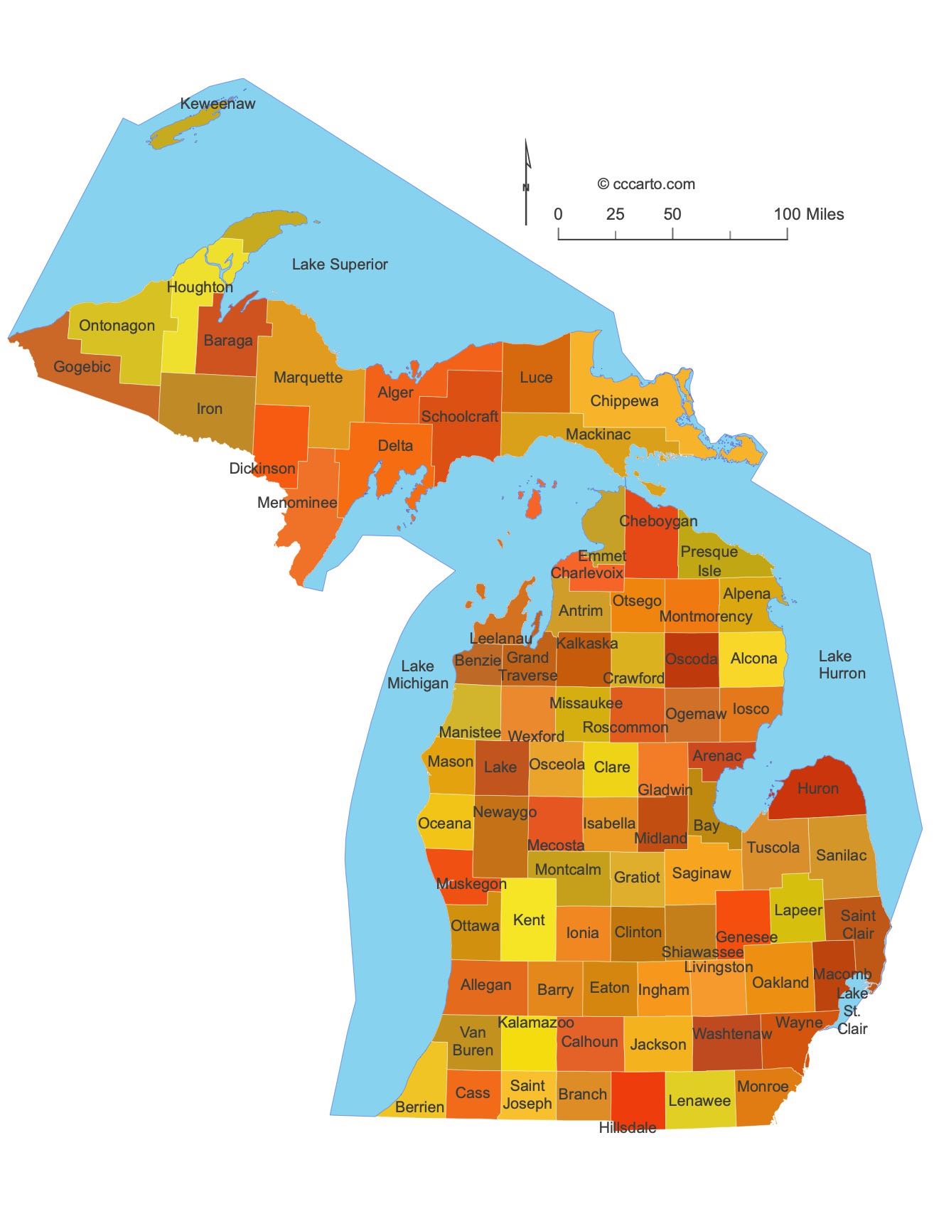
Michigan County Sizes State Map
Smallest County in Michigan State
Arenac County: 366 sq miles
Largest County in Michigan State
Marquette County: 1868 sq miles
Mean and Median Area of Counties in Michigan State
Mean Area: 595.75 sq miles
Median Area: 632.34 sq miles
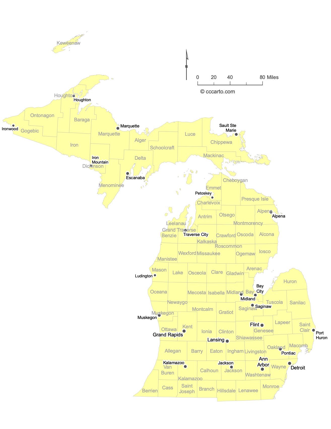
Major Cities of Michigan | Michigan Cities State Map
In Michigan State, most major cities are strategically located near the Great Lakes, rivers, or along historic transportation routes. Below are examples of each type:
1. Lakeside Cities
Detroit: The largest city in Michigan, located on the Detroit River, a major connection between the Great Lakes and international waters. Detroit is known as the center of the U.S. automobile industry and has a rich cultural and musical history, including Motown.
Grand Rapids: Located inland but along the Grand River, an important historic transportation route for trade. Known for its furniture manufacturing, Grand Rapids is now a major center for medical research, education, and cultural attractions.
Traverse City: Situated on the shores of Lake Michigan’s Grand Traverse Bay, this city is known for its picturesque setting, cherry orchards, and as a popular tourist destination, especially for its wineries and outdoor activities.
Muskegon: A historic port city located along the eastern shore of Lake Michigan. Muskegon has long been an important hub for lumber and shipping industries and is now a center for tourism and recreation, with its beautiful sandy beaches.
Holland: Positioned along the shores of Lake Michigan and Lake Macatawa, Holland is known for its Dutch heritage, its annual Tulip Time Festival, and its lakeside beaches and dunes.
2. River Cities
Lansing: The capital city of Michigan, located along the Grand River. Lansing serves as the political hub of the state and is also home to Michigan State University and a variety of cultural and economic activities.
Flint: Located along the Flint River, Flint was historically a major center for the auto industry, specifically for General Motors. While the city has faced challenges in recent years, efforts to revitalize its downtown and institutions continue.
Port Huron: A city on the St. Clair River, connecting Lake Huron and the Great Lakes system to the St. Lawrence Seaway. Port Huron is known for its role in shipping and as a gateway to Canada via the Blue Water Bridge.
Saginaw: Located on the Saginaw River, Saginaw was once a key center for the lumber and automotive industries. Today, the city is diversifying with new efforts in healthcare and education.
3. Historic Inland Routes
Ann Arbor: Situated along the Huron River, Ann Arbor is best known as the home of the University of Michigan, one of the top public research universities in the U.S. It has a vibrant arts, music, and academic scene, making it one of Michigan's most dynamic cities.
Kalamazoo: Located along historic rail lines and the Kalamazoo River, the city has a strong educational and cultural foundation, with Western Michigan University playing a major role in the local economy.
Battle Creek: Known as the "Cereal City," Battle Creek is home to Kellogg's and has a rich history tied to the early health food movement. It lies along the Kalamazoo and Battle Creek Rivers.
Jackson: Located along historic rail routes, Jackson was once a major center of industry, particularly in manufacturing and transportation. It is also notable for its role in the early automotive industry and the abolitionist movement.
Midland: Situated along the Tittabawassee River, Midland is the headquarters for Dow Chemical and has evolved into a hub for research and development, chemical engineering, and biotechnology.
Marquette: The largest city in the Upper Peninsula, located on the shore of Lake Superior. Marquette is known for its deep-water port and is a center for iron ore shipping. It also attracts visitors for its scenic beauty and outdoor activities.
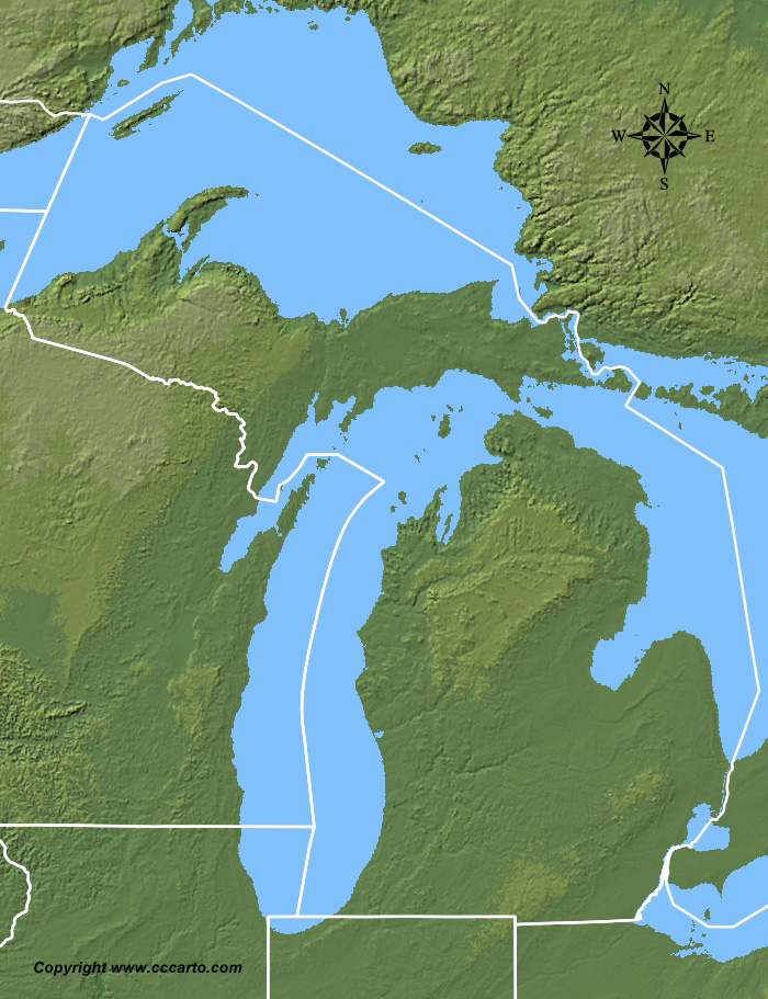
Michigan Topographic State Map | Shaded Relief
Michigan State offers a diverse range of terrains, shaped by its unique geology, climate, and natural features. From the rugged Upper Peninsula to the Great Lakes shores, the state presents a rich tapestry of landforms.
1. Coastal Plains
The western edge of Michigan features low-lying coastal areas along Lake Michigan. The Great Lakes provide rolling dunes and flatlands, with vast stretches of sandy beaches and coastal wetlands. Sleeping Bear Dunes National Lakeshore is one of the most famous dune formations, with towering sand dunes that rise over 400 feet above Lake Michigan.
2. Upper Peninsula Mountains
Running through the Upper Peninsula, the Porcupine Mountains, also known as the "Porkies," are among the most notable elevations, offering rugged and scenic landscapes. This area is heavily forested, with old-growth forests and waterfalls. The Keweenaw Peninsula, known for its ancient copper deposits, also features hilly terrain and dramatic cliffs along Lake Superior's shores.
3. Great Lakes Shorelines
Michigan is unique for its extensive shorelines along four of the five Great Lakes—Lake Michigan, Lake Huron, Lake Superior, and Lake Erie. The shorelines are diverse, featuring everything from steep bluffs to sandy beaches and extensive wetlands. The Straits of Mackinac, where Lake Michigan and Lake Huron meet, is another notable area, famous for the iconic Mackinac Bridge and the turbulent waters that flow beneath it.
4. Glacial Moraines
Much of Michigan’s landscape was shaped by glacial activity during the last Ice Age. The Lower Peninsula features numerous glacial moraines—hilly ridges formed by the accumulation of glacial debris. The Irish Hills region and the Waterloo State Recreation Area are well-known for their rolling terrain, a product of this glacial history. These areas are dotted with lakes, ponds, and wetlands created by glacial retreat.
5. Interior Lowlands
The central and southern regions of Michigan's Lower Peninsula are part of the interior lowlands, characterized by flat to gently rolling terrain. These areas are dominated by agricultural fields, forests, and large inland lakes such as Lake St. Clair and Lake Houghton. The Saginaw Valley is one of the most fertile agricultural regions in the state, known for its extensive production of crops like sugar beets, corn, and soybeans.
6. River Valleys
Michigan's major rivers, including the Grand, Kalamazoo, and Saginaw Rivers, flow through broad valleys that cut across the interior lowlands. These river valleys provide vital water resources and fertile soils for agriculture. They also serve as important natural corridors for wildlife and recreation, with many areas along these rivers protected as parks and natural reserves.
7. The Thumb Region
The Thumb Region, located in Michigan's Lower Peninsula, is a distinct landform that juts out into Lake Huron. This region is relatively flat, with extensive agricultural fields and long stretches of coastline. Port Austin and Caseville are popular coastal towns in this region, known for their beaches and proximity to the scenic Pointe Aux Barques Lighthouse.
8. Islands and Archipelagos
Michigan is home to numerous islands, the most famous of which is Mackinac Island, located in Lake Huron. This island is known for its historic landmarks, scenic views, and the absence of motor vehicles. Other notable islands include Isle Royale in Lake Superior, a remote national park known for its wilderness and wildlife, including wolves and moose, and the Beaver Island archipelago in Lake Michigan.
9. Wetlands and Marshes
Michigan has a wealth of wetland ecosystems, particularly in the Saginaw Bay and along the coastal areas of the Great Lakes. These wetlands provide essential habitat for migratory birds and other wildlife, and they play a crucial role in maintaining the health of the Great Lakes. The Shiawassee National Wildlife Refuge is a prime example of a wetland area that supports diverse bird populations, including bald eagles and sandhill cranes.
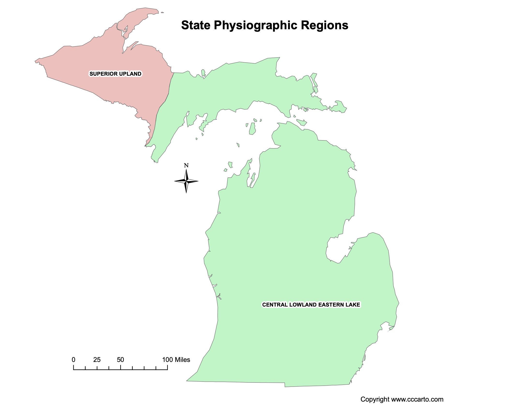
Michigan Physiographic Regions State Map
Central Lowland - Eastern Lake
This region covers much of Michigan's Lower Peninsula, with rolling plains, forested areas, and significant agriculture.
Superior Upland
In Michigan’s Upper Peninsula, the Superior Upland is a rugged, forested region with ancient rock formations and numerous lakes and rivers.
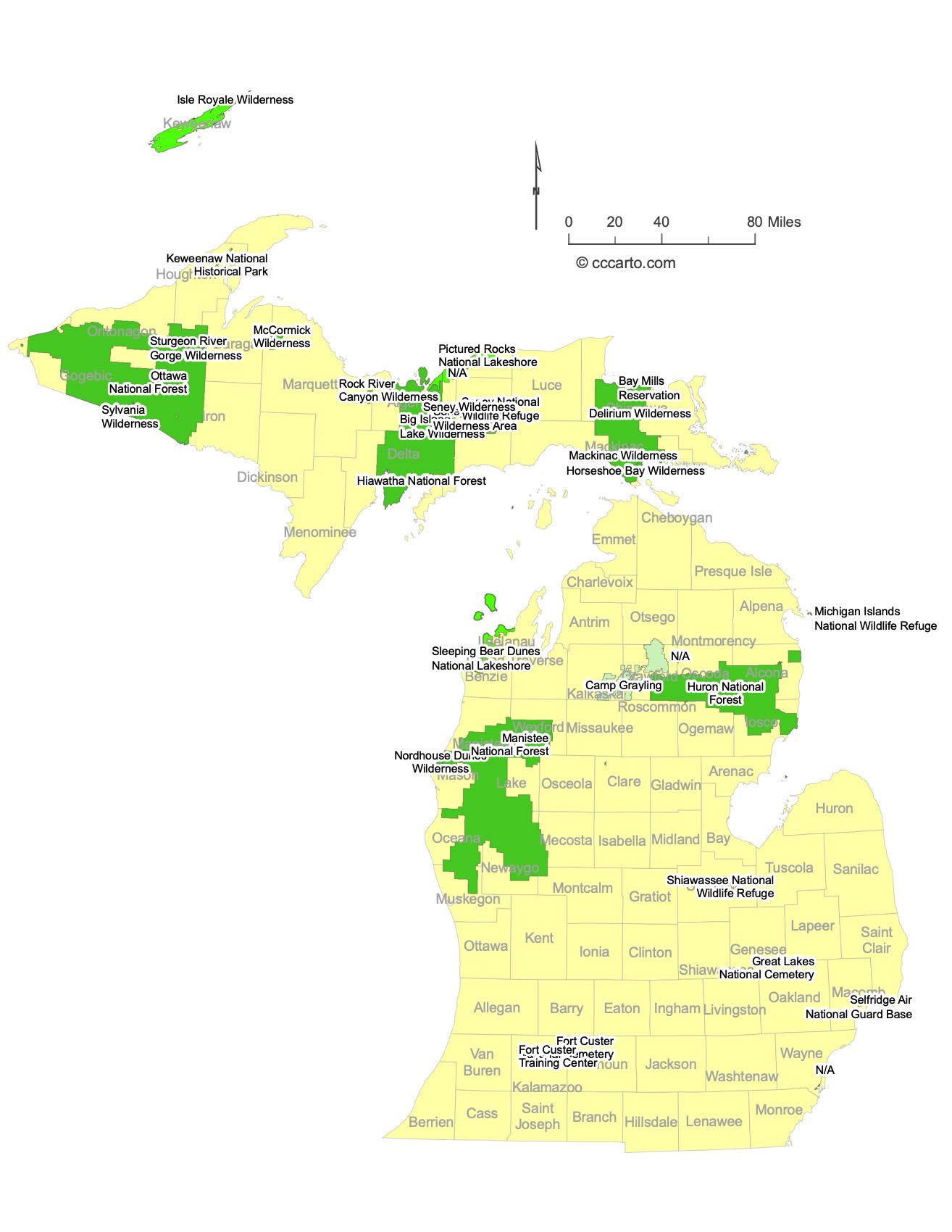
Largest an Most Interesting Federal Lands in Michigan
1. Isle Royale National Park
Isle Royale National Park encompasses a large wilderness island in Lake Superior, known for its unique ecosystem, hiking trails, and isolation. The park is home to diverse wildlife, including wolves and moose, and offers visitors an experience of solitude and untouched wilderness.
2. Sleeping Bear Dunes National Lakeshore
This lakeshore is known for its massive sand dunes, scenic views, and historic maritime culture. The towering dunes along Lake Michigan offer stunning vistas, and visitors can explore the area's forests, beaches, and the historic Glen Haven Village.
3. Ottawa National Forest
Located in the western Upper Peninsula, Ottawa National Forest spans nearly one million acres and offers a variety of outdoor activities, including hiking, fishing, and camping. The forest is also home to numerous lakes and rivers, as well as old-growth forests, providing a sanctuary for wildlife.
4. Hiawatha National Forest
Hiawatha National Forest covers large portions of both the eastern and western Upper Peninsula. It features diverse landscapes, including wetlands, dunes, and rugged shorelines. The forest is known for its extensive recreational opportunities, including boating, fishing, hiking, and snowmobiling.
5. Sylvania Wilderness
The Sylvania Wilderness is part of the Ottawa National Forest and spans over 18,000 acres. This pristine wilderness area is renowned for its clear, undeveloped lakes and old-growth forests. It is a popular destination for canoeing, fishing, and backcountry camping.
6. Manistee National Forest
Manistee National Forest is located in the Lower Peninsula and offers a wide variety of recreational activities, including hiking, mountain biking, fishing, and camping. The forest features the scenic Manistee River, known for its excellent trout fishing and picturesque views.
7. Mackinac Wilderness
Mackinac Wilderness, part of the Hiawatha National Forest, is a designated wilderness area located on Michigan’s Upper Peninsula. It offers a remote and rugged landscape of forests, lakes, and wetlands, providing excellent opportunities for backcountry camping, hiking, and wildlife observation.
8. Huron National Forest
Huron National Forest is located in northeastern Michigan’s Lower Peninsula. It is known for its sand dunes, river systems, and dense forests. The forest offers hiking, off-road vehicle trails, and camping, and is a popular destination for wildlife enthusiasts and bird watchers.
9. Nordhouse Dunes Wilderness
The Nordhouse Dunes Wilderness is part of the Manistee National Forest, situated along the eastern shore of Lake Michigan. It is known for its rolling sand dunes and remote beaches. Visitors can explore the wilderness through hiking and camping, enjoying the scenic beauty and solitude of this area.
10. Delirium Wilderness
Located within the Ottawa National Forest, Delirium Wilderness is a relatively remote and undeveloped area. It is known for its rugged terrain, old-growth forests, and numerous lakes, making it a great location for hiking, canoeing, and experiencing Michigan’s natural beauty.
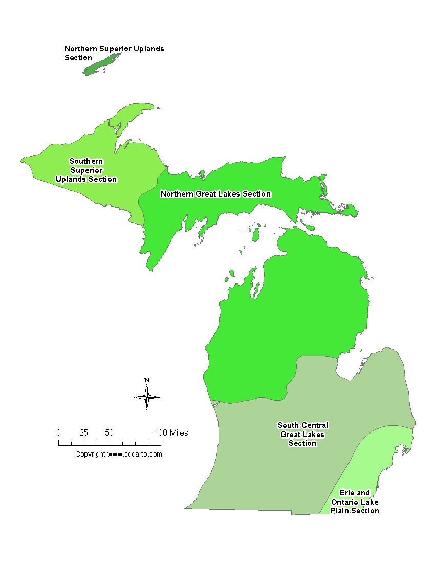
Michigan Ecoregions State Map | EPA Ecological Zones
Erie and Ontario Lake Plain Section
This region in southern Michigan consists of low plains near the Great Lakes, supporting agricultural activities and urban areas.
Northern Great Lakes Section
Covering the northern part of the Lower Peninsula, this section includes forests, lakes, and rivers, making it an important ecological area.
Southern Superior Uplands Section
This section in the Upper Peninsula is characterized by its rugged terrain, forests, and proximity to Lake Superior.
Northern Superior Uplands Section
Also located in the Upper Peninsula, this section is noted for its rocky landscapes and forested ecosystems.
South Central Great Lakes Section
This ecoregion encompasses parts of Michigan’s southern Lower Peninsula and is known for its rich soils and agricultural production.