

Minnesota State Maps | Complete Map Collection
Minnesota State Maps: Detailed Maps for Counties, Cities, Federal Areas, Physiographic & Ecoregions
Welcome to our comprehensive collection of Minnesota State Maps, meticulously curated to provide detailed, high-resolution visualizations of the state’s geography, political boundaries, and natural regions. These maps are designed for students, researchers, planners, and anyone seeking an in-depth visual reference.
- Counties and Cities: Clearly defined county boundaries and major cities for planning, education, and demographic reference.
- Federal Areas: National parks, forests, monuments, wildlife refuges, military installations, and other federally managed lands.
- Physiographic Regions: Major landforms and terrain features such as mountains, plains, valleys, plateaus, and coastal areas.
- Ecoregions: Ecological zones representing forests, grasslands, deserts, wetlands, and other biodiversity regions.
Map Profile
- Format: JPEG
- Color: RGB
- Resolution: ~72 DPI
- Typical image size: ~1300 × 1700 px
- Paper size: Letter (8.5 × 11 inches)
- Layouts: Portrait and Landscape
- File size: ~100–500 KB
Print tip: In your print dialog select Letter (8.5×11), choose Portrait or Landscape, and use Fit to Page (or Scale - to fit).
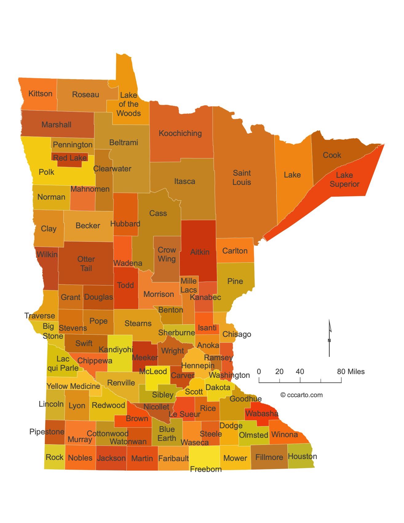
Minnesota Counties Interesting Facts
Minnesota’s 87 counties stretch from prairie to Boundary Waters; Twin Cities counties dominate population.
- Number of counties: 87 — MN House Research
- First & last established: Territorial counties (1849+); last created Lake of the Woods (1923) — Newberry Atlas
- Highest & lowest county: Highest Eagle Mountain; lowest Lake Superior shore — both in Cook County — USGS
- Most & least populated: Most: Hennepin; Least: Traverse
- Least & most developed: Most: Hennepin; Least: Traverse
- Most geographically diverse: St. Louis County (BWCAW, North Shore, Iron Range)
- Strangest-shaped county: Lake of the Woods County — includes the famous “Northwest Angle”
- State’s Biggest Commodity: Corn (with soybeans & hogs also high). MN DEED · MDA 2023
- Largest Private Employer: Mayo Clinic
- Top 3 Non-English Languages: Spanish, Somali, Hmong — DataUSA (ACS)
About CCCarto – Minnesota State Maps Creator
CCCarto has been producing professional digital and GIS maps for large companies, government agencies, and educational institutions since 1988. With over 35 years of cartographic experience, our Minnesota state maps are designed to the highest standards of accuracy, clarity, and usability.
Our map collection spans counties, cities, federal lands, ecoregions, physiographic regions, topographic relief, and more — giving students, researchers, educators, planners, and curious explorers the best Minnesota state map resources available online. Every map is optimized for both screen viewing and letter-size printing.
Explore our full U.S. State Maps collection, or browse our Geology Maps, Travel Maps, and Energy Maps.
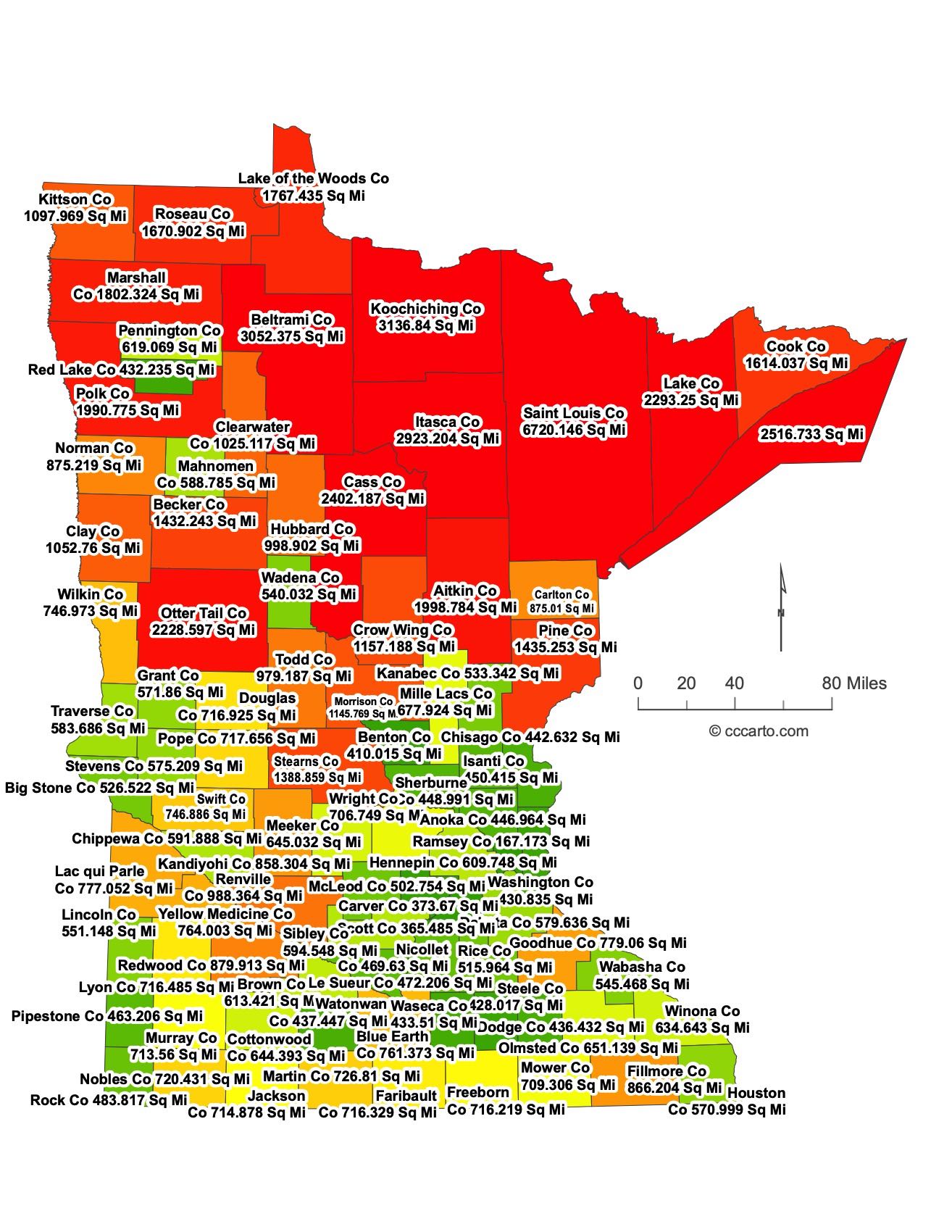
Minnesota County Sizes State Map
Smallest County in Minnesota State
Ramsey County: 167 sq miles
Largest County in Minnesota State
St. Louis County: 6,720 sq miles
Mean and Median Area of Counties in Minnesota State
Mean Area: 771 sq miles
Median Area: 614 sq miles
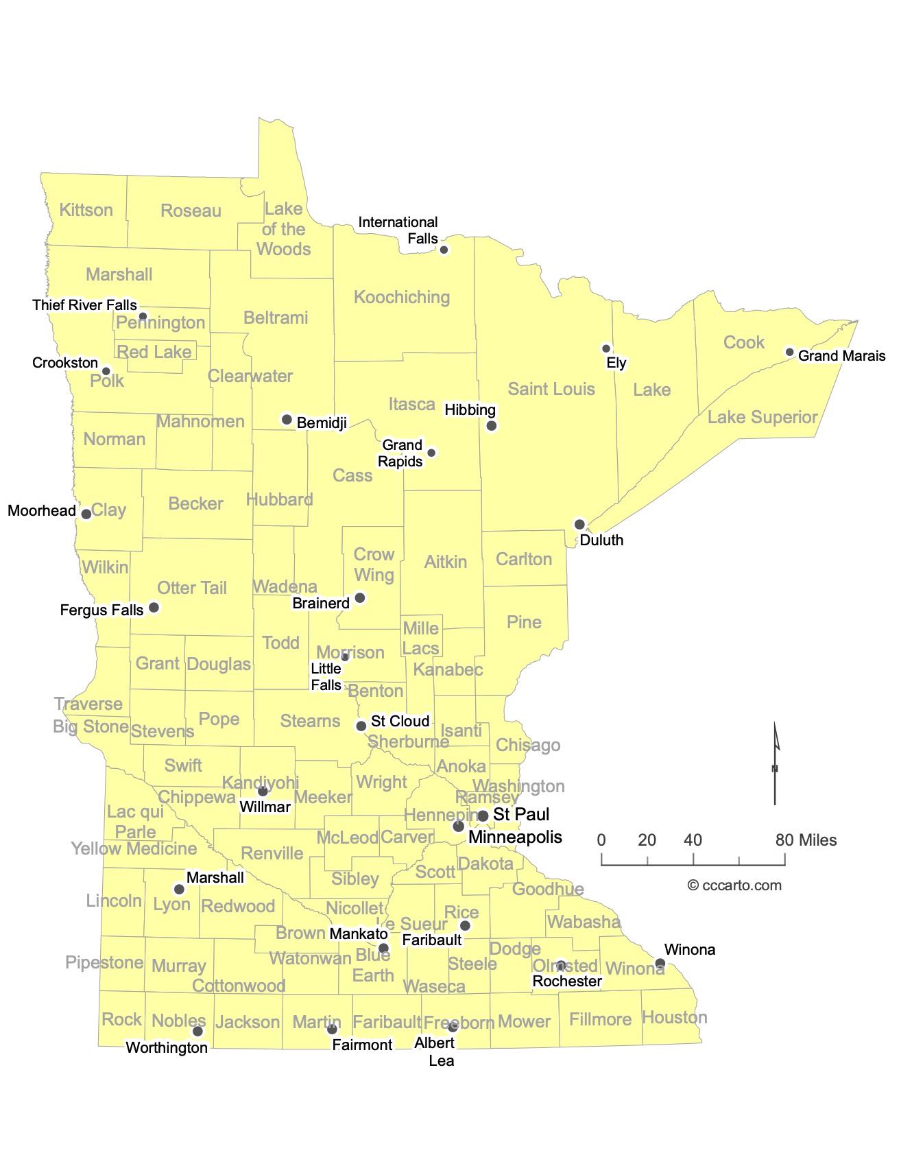
Major Cities of Minnesota | Minnesota Cities State Map
Minnesota’s major cities are distributed across the state, with many located along rivers or historical transportation routes. The state is known for its vibrant urban centers, cultural hubs, and proximity to natural landscapes. Below are examples of Minnesota's largest and most significant cities:
1. Minneapolis
Minneapolis, the largest city in Minnesota, is located along the Mississippi River. Known for its thriving arts scene, vibrant neighborhoods, and numerous lakes, Minneapolis is an economic and cultural hub. It is part of the Twin Cities metropolitan area along with St. Paul, the state capital, and is home to Fortune 500 companies, major sports teams, and world-class theaters and museums.
2. St. Paul
St. Paul, Minnesota’s capital city, lies east of Minneapolis along the Mississippi River. It is known for its historic architecture, government buildings, and vibrant cultural institutions. St. Paul is home to the Minnesota State Capitol, the Science Museum of Minnesota, and the Xcel Energy Center, where major concerts and sporting events are held. The city's historic charm and connection to the river make it a popular tourist destination.
3. Rochester
Rochester is located in southeastern Minnesota and is internationally known as the home of the Mayo Clinic, one of the top medical research and healthcare institutions in the world. As a result, the city has a strong healthcare industry and a vibrant economy. Rochester also offers parks, riverside trails, and a growing arts and cultural scene, making it one of Minnesota’s fastest-growing cities.
4. Duluth
Duluth, located on the shores of Lake Superior in northeastern Minnesota, is a major port city. It serves as a gateway for shipping and industry, particularly for iron ore and grain shipments. The city is also a popular tourist destination, known for its scenic lake views, the historic Aerial Lift Bridge, and access to outdoor recreation like hiking, skiing, and boating along the North Shore.
5. Bloomington
Located just south of Minneapolis, Bloomington is home to the Mall of America, the largest shopping mall in the United States. The city is a major retail and entertainment hub, drawing millions of visitors annually. It is also known for its proximity to the Minneapolis-Saint Paul International Airport and the Minnesota Valley National Wildlife Refuge, offering a mix of urban and natural attractions.
6. St. Cloud
St. Cloud is situated along the Mississippi River in central Minnesota. It serves as a regional hub for education, healthcare, and commerce in the area. The city is home to St. Cloud State University, one of Minnesota’s largest public universities. St. Cloud offers access to scenic river views, parks, and cultural events, making it an important center for the surrounding region.
7. Mankato
Mankato is located in southern Minnesota along the Minnesota River. It is known for its regional university, Minnesota State University, Mankato, which brings a youthful and academic atmosphere to the city. Mankato is also a center for agriculture and manufacturing and offers recreational activities like hiking, biking, and kayaking in nearby parks and along the river.
8. Moorhead
Moorhead is situated in western Minnesota, directly across the Red River from Fargo, North Dakota. It is an agricultural hub and a key gateway to the Great Plains. Moorhead is home to Concordia College and offers a mix of suburban living, access to outdoor recreation, and cultural institutions, benefiting from its proximity to Fargo’s amenities and industries.
9. Burnsville
Burnsville, a suburb of Minneapolis, is located along the Minnesota River and is known for its suburban neighborhoods and access to nature. The city features parks, lakes, and the Buck Hill ski area. Burnsville serves as a residential and commercial hub within the Twin Cities metropolitan area and offers easy access to urban amenities while maintaining a suburban character.
10. Eden Prairie
Located southwest of Minneapolis, Eden Prairie is a prosperous suburb known for its high quality of life, excellent schools, and strong business community. The city is home to numerous corporate headquarters and offers parks, lakes, and recreational opportunities, making it a popular place for families and professionals.
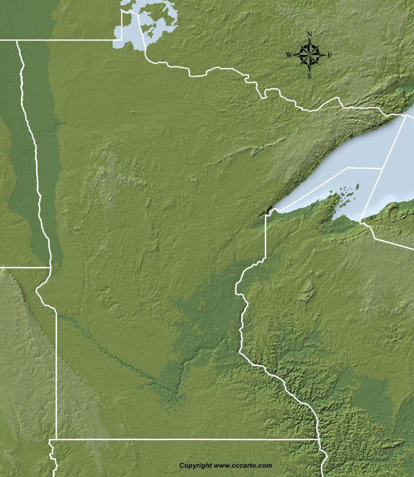
Minnesota Topographic State Map | Shaded Relief
Minnesota features varied topography, shaped by glaciers and its location in the northern part of the Central Lowland. From the lowland plains to the Superior Upland, the state boasts a range of landscapes that include lakes, forests, rolling hills, and fertile farmland. The diversity of landforms provides a range of natural habitats and resources.
1. Central Lowland
The Central Lowland region dominates much of southern and central Minnesota. It consists of flat to gently rolling plains, including rich farmlands that contribute to the state’s agricultural output.
2. Superior Upland
Northern Minnesota is part of the Superior Upland, an ancient landscape of forests, lakes, and rocky terrain formed by glaciation. This area includes the state's highest elevations and the iconic Boundary Waters Canoe Area Wilderness.
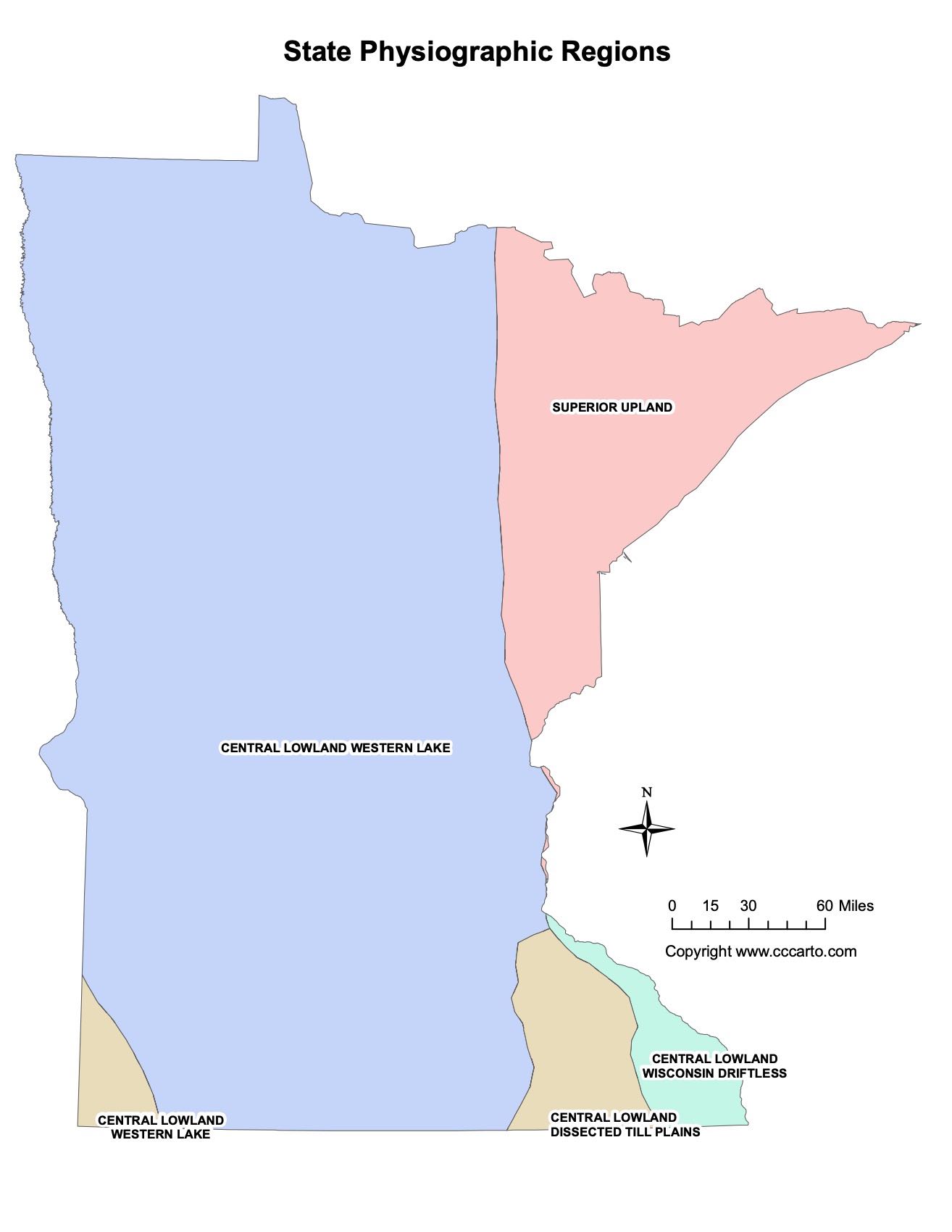
Minnesota Physiographic Regions State Map
Central Lowland, Dissected Till Plains
This region covers much of the southern part of Minnesota. It features a landscape shaped by glaciation and later erosion, leading to rolling hills and valleys. The fertile soils in this area make it ideal for agriculture, especially for growing crops like corn and soybeans.
Central Lowland, Western Lake
Western Lake, part of the Central Lowland, encompasses the western and central regions of Minnesota. This area is known for its large number of lakes and wetlands, as well as gently rolling terrain that provides fertile farmland.
Central Lowland, Wisconsin Driftless
The Wisconsin Driftless area, located in the southeastern part of Minnesota, is unique in that it was not glaciated during the last Ice Age. This has resulted in a landscape of steep bluffs, deep valleys, and rolling hills. The area is known for its scenic beauty and is popular for outdoor activities like hiking and fishing.
Superior Upland
The Superior Upland region encompasses the northeastern part of Minnesota, including areas near Lake Superior. This region is characterized by rugged, rocky terrain formed by ancient volcanic activity and shaped by glaciation. It is covered in dense forests and is home to many lakes and rivers, including the iconic Boundary Waters Canoe Area Wilderness.
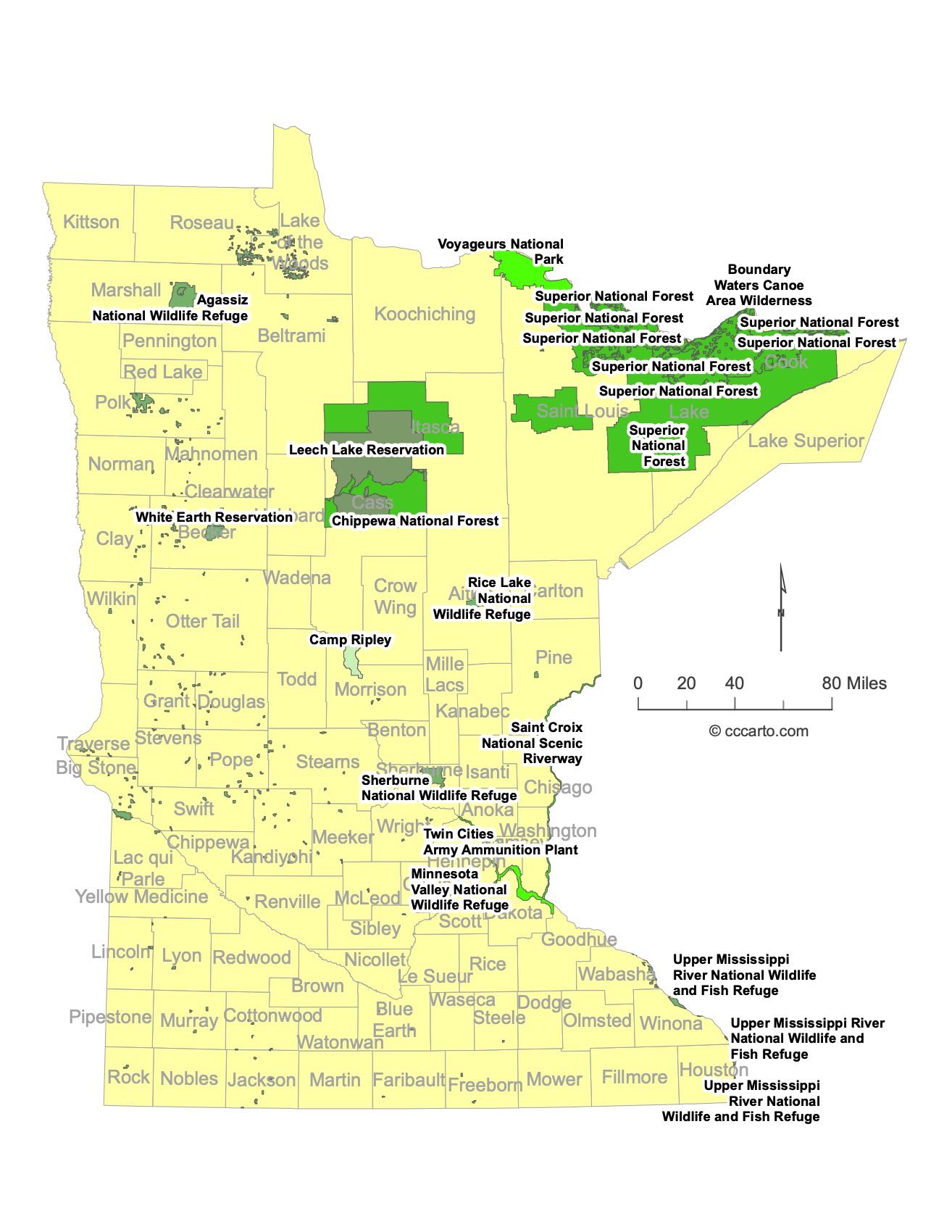
Minnesota Federal Lands State Map | National Parks & Protected Areas
1. Voyageurs National Park
Voyageurs National Park, located in northern Minnesota, is named after the French-Canadian fur traders who once paddled its waterways. The park covers over 218,000 acres and is dominated by interconnected lakes, including Rainy, Kabetogama, and Namakan Lakes. It is a haven for boating, canoeing, fishing, and wildlife watching. The park's remote location and vast water networks make it a popular destination for backcountry camping and stargazing.
2. Boundary Waters Canoe Area Wilderness (BWCAW)
The Boundary Waters Canoe Area Wilderness is a vast, federally protected wilderness area located within the Superior National Forest in northeastern Minnesota. Covering over 1 million acres, it contains over 1,000 lakes and rivers, making it one of the best canoeing and kayaking destinations in the country. The BWCAW is known for its pristine wilderness, rich biodiversity, and opportunities for solitude, with only minimal human impact allowed. The area also provides excellent fishing, camping, and hiking opportunities.
3. Superior National Forest
Superior National Forest spans 3.9 million acres in northeastern Minnesota, encompassing the Boundary Waters and vast tracts of boreal forest. The forest is home to hundreds of lakes, rivers, and streams, and it offers a wide range of outdoor recreational activities such as hiking, fishing, canoeing, and snowmobiling. Visitors can also enjoy exploring the scenic byways that pass through the forest, offering breathtaking views of Minnesota's rugged northern landscapes.
4. Mississippi National River and Recreation Area
This 72-mile-long river corridor runs through the heart of the Twin Cities, following the path of the Mississippi River. The Mississippi National River and Recreation Area encompasses over 54,000 acres and protects both natural and historic sites along the river, including the St. Anthony Falls, Fort Snelling, and Minnehaha Park. It provides urban recreational opportunities such as hiking, biking, fishing, and birdwatching, while preserving important cultural and historical landmarks.
5. Chippewa National Forest
Located in north-central Minnesota, Chippewa National Forest covers over 1.6 million acres and is named after the Ojibwe (Chippewa) people who have lived in the area for centuries. The forest is known for its extensive lakes, wetlands, and pine forests, offering a variety of recreational opportunities, including camping, hiking, boating, and wildlife viewing. The forest is home to one of the largest populations of bald eagles in the lower 48 states.
6. Minnesota Valley National Wildlife Refuge
This urban wildlife refuge stretches along the Minnesota River and covers over 14,000 acres near the Twin Cities. The Minnesota Valley National Wildlife Refuge protects important habitats for migratory birds, waterfowl, and other wildlife species, offering a unique blend of nature and urban environments. The refuge has several visitor centers, hiking trails, and opportunities for wildlife observation and environmental education.
7. Agassiz National Wildlife Refuge
Located in northwestern Minnesota, Agassiz National Wildlife Refuge covers over 61,000 acres of marshes, lakes, and grasslands. It is named after the prehistoric Lake Agassiz, which once covered much of the region. The refuge is home to a wide variety of wildlife, including moose, wolves, and migratory birds, making it a prime destination for birdwatching, wildlife photography, and hiking.
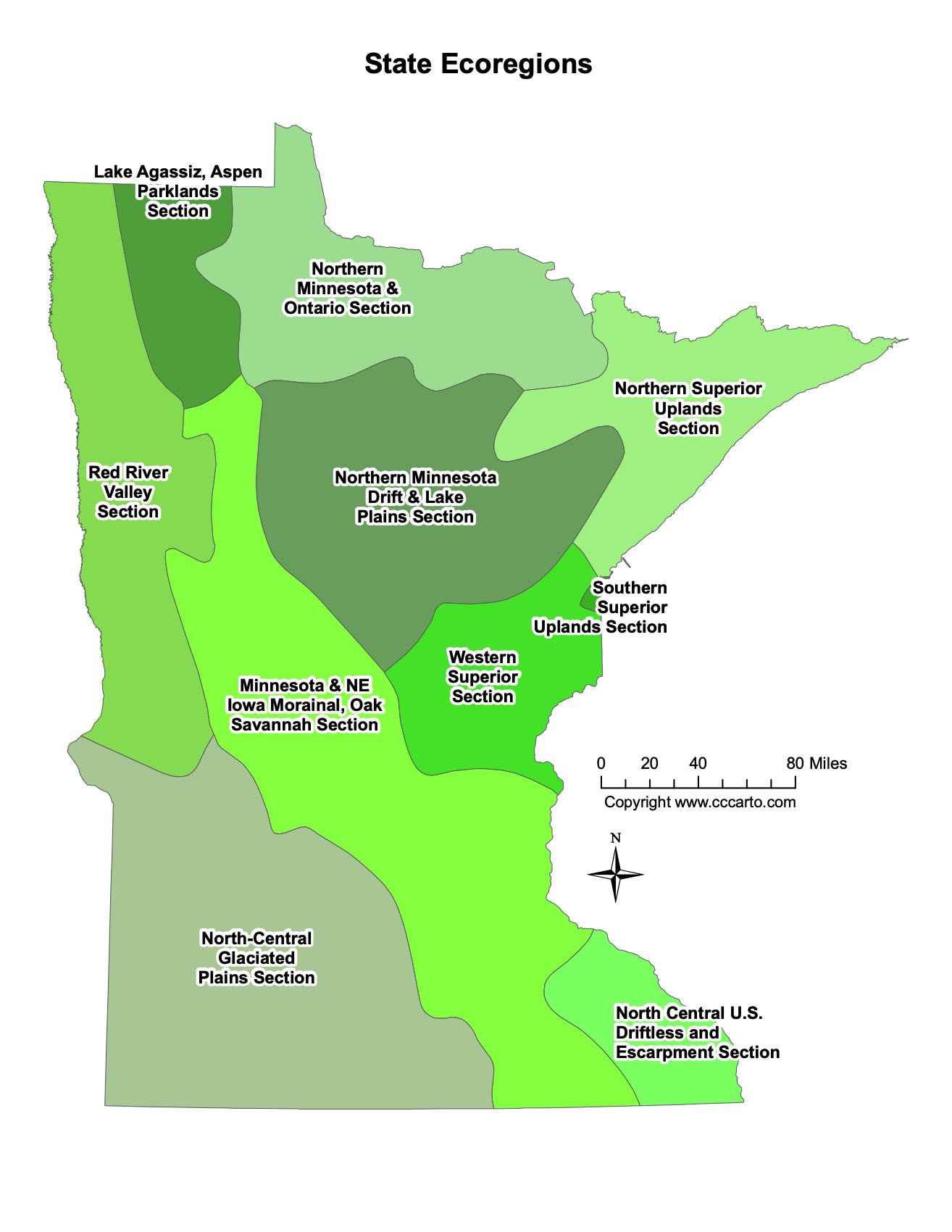
Minnesota Ecoregions State Map | EPA Ecological Zones
Lake Agassiz, Aspen Parklands Section
The Lake Agassiz, Aspen Parklands Section is located in the northwestern part of Minnesota. It is characterized by a mix of grasslands and aspen forests, shaped by the remnants of glacial Lake Agassiz. This area supports a variety of wildlife, including elk, deer, and waterfowl, and is known for its flat terrain, wetlands, and scattered groves of trees. The region also provides important migratory habitats for birds, making it a key area for conservation and wildlife observation.
North-Central Glaciated Plains Section
This ecoregion covers central Minnesota, where the landscape was heavily shaped by glacial activity. It is marked by rolling plains, lakes, and wetlands, with soils that support a mix of agricultural lands and forests. The glaciated plains are known for their diverse habitats, including prairies, woodlands, and wetlands, and are important for farming, particularly crops like corn and soybeans.
Northern Minnesota & Ontario Section
This section spans the northern part of Minnesota and extends into Canada. It is dominated by boreal forests, including spruce, pine, and fir, and features numerous lakes and rivers. The area is home to the Boundary Waters Canoe Area Wilderness and offers critical habitats for species like moose, wolves, and black bears. The rugged, forested terrain is ideal for outdoor activities such as canoeing, hiking, and wildlife observation.
Northern Minnesota Drift & Lake Plains Section
The Northern Minnesota Drift & Lake Plains Section covers much of the north-central region of the state, characterized by glacial deposits and numerous lakes. This ecoregion is a transition zone between forested areas and agricultural lands, with mixed hardwood forests, wetlands, and open fields. The area supports diverse plant and animal species, and recreational activities such as fishing, boating, and camping are popular here.
Northern Superior Uplands Section
This section encompasses the northeastern part of Minnesota, where the landscape is dominated by rugged terrain and large bodies of water like Lake Superior. The area is known for its boreal forests, rocky outcrops, and numerous lakes and rivers. The Northern Superior Uplands support timber production and offer excellent opportunities for outdoor recreation, including camping, hiking, and fishing.
Red River Valley Section
The Red River Valley Section, located in western Minnesota, is part of the broader floodplain of the Red River of the North. This region is characterized by flat, fertile plains that are ideal for agriculture, particularly for crops like wheat and sugar beets. The rich soils are a result of the historic glacial Lake Agassiz, and the valley plays a crucial role in the state's agricultural output.
Southern Superior Uplands Section
The Southern Superior Uplands Section, located in the northeastern part of the state, features rugged, forested terrain with high elevations. This region is dominated by rocky outcrops, dense forests, and numerous lakes. It supports a diverse range of wildlife and provides important timber resources. The area is also a popular destination for outdoor enthusiasts seeking hiking, fishing, and camping opportunities.
Western Superior Section
This section is located along the western shores of Lake Superior, where the landscape is shaped by glacial activity and features rocky coastlines, forests, and wetlands. The Western Superior Section is home to diverse ecosystems, including boreal forests and freshwater habitats. It is a key region for conservation and recreation, with many protected areas offering opportunities for boating, hiking, and wildlife observation.
North Central U.S. Driftless and Escarpment Section
The Driftless and Escarpment Section, found in southeastern Minnesota, is unique for its lack of glaciation, which has resulted in a rugged landscape of bluffs, valleys, and escarpments. The area is known for its karst topography, with numerous caves and sinkholes. The region supports oak savannas, prairies, and hardwood forests, and is a popular area for outdoor activities such as hiking, birdwatching, and trout fishing in its cold-water streams.
Minnesota & NE Iowa Morainal, Oak Savannah Section
This section covers parts of southern Minnesota and extends into northeastern Iowa. It is characterized by rolling hills, moraines (glacially formed ridges), and oak savannas. The mix of prairie and oak woodlands creates a diverse ecosystem that supports a wide range of wildlife. Historically, this area was shaped by fire and grazing, which maintained the savanna landscapes. Today, conservation efforts focus on preserving these unique habitats.