

Georgia State Maps | Complete Map Collection
Georgia State Maps: Detailed Maps for Counties, Cities, Federal Areas, Physiographic & Ecoregions
Welcome to our comprehensive collection of Georgia State Maps, meticulously curated to provide detailed, high-resolution visualizations of the state’s geography, political boundaries, and natural regions. These maps are designed for students, researchers, planners, and anyone seeking an in-depth visual reference.
- Counties and Cities: Clearly defined county boundaries and major cities for planning, education, and demographic reference.
- Federal Areas: National parks, forests, monuments, wildlife refuges, military installations, and other federally managed lands.
- Physiographic Regions: Major landforms and terrain features such as mountains, plains, valleys, plateaus, and coastal areas.
- Ecoregions: Ecological zones representing forests, grasslands, deserts, wetlands, and other biodiversity regions.
Map Profile
- Format: JPEG
- Color: RGB
- Resolution: ~72 DPI
- Typical image size: ~1300 × 1700 px
- Paper size: Letter (8.5 × 11 inches)
- Layouts: Portrait and Landscape
- File size: ~100–500 KB
Print tip: In your print dialog select Letter (8.5×11), choose Portrait or Landscape, and use Fit to Page (or Scale - to fit).

Georgia State Counties Interesting Facts
Georgia State's 159 counties are the most east of the Mississippi; Atlanta core counties hold the plurality.
- Number of counties: 159 — List
- First & last established: 1777 originals; last created Peach (1924) — Newberry Atlas
- Highest & lowest county: Highest at Brasstown Bald (Towns); lowest sea level on coast (e.g., Chatham) — USGS
- Most & least populated: Most: Fulton; Least: Taliaferro
- Least & most developed (proxy): Most: Fulton; Least: Taliaferro
- Most geographically diverse: Rabun County (Blue Ridge peaks, lakes, gorges)
- Strangest-shaped county: Fulton County (long, skinny north-south corridor)
- State’s Biggest Commodity: Poultry/broilers. GA DoA
- Largest Private Employer: Walmart (statewide). State list
- Top 3 Non-English Languages: Spanish, Vietnamese, Chinese — DataUSA
About CCCarto – Georgia State Maps Creator
CCCarto has been producing professional digital and GIS maps for large companies, government agencies, and educational institutions since 1988. With over 35 years of cartographic experience, our Georgia state maps are designed to the highest standards of accuracy, clarity, and usability.
Our map collection spans counties, cities, federal lands, ecoregions, physiographic regions, topographic relief, and more — giving students, researchers, educators, planners, and curious explorers the best Georgia state map resources available online. Every map is optimized for both screen viewing and letter-size printing.
Explore our full U.S. State Maps collection, or browse our Geology Maps, Travel Maps, and Energy Maps.

Georgia County Sizes State Map
Smallest County in Georgia State
Clarke County: 121 sq miles
Largest County in Georgia State
Ware County: 907 sq miles
Mean and Median Area of Counties in Georgia State
Mean Area: 374 sq miles
Median Area: 347 sq miles

Major Cities of Georgia | Georgia Cities State Map
In Georgia State, major cities are located near coastal ports, transportation routes, or historic regions. Below are some key examples:
1. Coastal Ports
Savannah: Georgia’s historic coastal city and major Atlantic seaport, known for its cobblestone streets, antebellum architecture, and the bustling Savannah Riverfront. Savannah is an important hub for international shipping and tourism.
Brunswick: A significant port city located on the southeastern coast of Georgia. Brunswick is known for its deep-water port, vital for Georgia’s seafood and automobile industries, and its proximity to the Golden Isles, a group of barrier islands popular with tourists.
St. Marys: A smaller coastal town near the Florida border, St. Marys serves as the gateway to Cumberland Island National Seashore. It has historical significance dating back to colonial times and is a popular destination for nature tourism.
2. Inland Routes
Atlanta: The capital city and a major transportation hub, located in north Georgia. Atlanta is the most populous city in the state and serves as the economic and cultural center, with major industries in transportation, telecommunications, and media. Hartsfield-Jackson Atlanta International Airport is one of the busiest airports in the world, connecting Atlanta to international destinations.
Augusta: A key inland city located along the Savannah River. Augusta is known for the annual Masters Golf Tournament, as well as its historical importance during the American Revolution. It is also a hub for medical and military industries.
Macon: Located in central Georgia, Macon sits at the fall line, where the rolling Piedmont region meets the flatter Coastal Plain. Known as the "Heart of Georgia," Macon has a rich musical history and serves as an economic center for the region. It is also home to several historical sites and universities.
Columbus: Situated on the Chattahoochee River in western Georgia, Columbus is a major manufacturing and military hub, home to Fort Moore (formerly Fort Benning). Its riverfront has been revitalized for tourism and recreation, including white-water rafting and historic landmarks.
Albany: Located in southwest Georgia, Albany is an agricultural and transportation center for the region. It has a strong connection to the peanut farming industry and is home to historical landmarks and museums celebrating the area’s civil rights heritage.
3. Historic and Cultural Cities
Athens: Home to the University of Georgia, Athens is a vibrant college town located northeast of Atlanta. Known for its music scene, historic architecture, and cultural festivals, Athens has a unique blend of academic and artistic communities.
Milledgeville: Once the capital of Georgia, Milledgeville is steeped in history and located in the central part of the state. The city is known for its well-preserved antebellum architecture and historic landmarks, including the Old Governor’s Mansion.
Rome: Situated in the foothills of the Appalachian Mountains, Rome is known for its historic downtown, beautiful river views, and educational institutions. The city has a rich history, reflected in its architecture and cultural events, and serves as an economic center for northwestern Georgia.
4. Industrial and Economic Centers
Dalton: Known as the "Carpet Capital of the World," Dalton is located in northwest Georgia and is a major center for the carpet and flooring industry. It is one of the key manufacturing cities in the state, with a significant portion of U.S. carpet production taking place in this region.
Valdosta: Situated in southern Georgia near the Florida border, Valdosta is an agricultural and industrial hub, with significant contributions to the production of tobacco, cotton, and timber. It is also home to Valdosta State University and has a growing tourist industry.
5. Smaller but Notable Cities
Gainesville: Often called the "Poultry Capital of the World," Gainesville is located northeast of Atlanta and serves as a center for poultry processing and agribusiness. Its proximity to Lake Lanier also makes it a popular destination for water recreation and tourism.
Hinesville: Located in coastal Georgia, near Fort Stewart, Hinesville is closely tied to the U.S. Army base, making it an important military community. It has experienced growth due to its connection to the base and serves as a regional economic center.
Newnan: A growing city located southwest of Atlanta, Newnan is known for its well-preserved antebellum homes and rapidly expanding suburban communities. It serves as a residential and commercial center for the Atlanta metropolitan area.


Georgia Topographic State Map | Shaded Relief
Georgia features a variety of terrains, from the Appalachian Plateaus to coastal plains. Key regions include:
1. Appalachian Plateaus
The northwest region features rugged hills and valleys of the Cumberland Plateau.
2. Coastal Plain
The southern and eastern part of Georgia, characterized by flat land and fertile soils.
3. Piedmont
The central region of Georgia, known for rolling hills and major urban centers like Atlanta.

Georgia Physiographic Regions State Map
Appalachian Plateaus, Cumberland Plateau
The Appalachian Plateaus region includes the Cumberland Plateau in northwest Georgia. This area is characterized by flat-topped mountains and deep valleys, offering rugged terrain and scenic landscapes. It's known for its coal deposits and forested areas.
Blue Ridge, Southern
The Blue Ridge region lies in the northeastern part of Georgia. It consists of high mountains and ridges, including some of the state's tallest peaks. This region is part of the larger Blue Ridge Mountain range and is known for its diverse forests, waterfalls, and mountainous beauty.
Coastal Plain, East Gulf Coastal Plain
The East Gulf Coastal Plain occupies the southern part of Georgia. It consists of flat, low-lying terrain with fertile soils, making it ideal for agriculture. This region is also known for its swamps, wetlands, and pine forests.
Coastal Plain, Sea Island
The Sea Island Coastal Plain encompasses Georgia's barrier islands and the adjacent coastal areas. This region features sandy beaches, marshes, and dunes. The Sea Islands are home to unique ecosystems and are a significant tourist attraction.
Piedmont, Piedmont Upland
The Piedmont region is located in central Georgia. It is characterized by rolling hills and is home to Georgia's most populous cities, including Atlanta. The Piedmont Upland includes areas of higher elevation and is known for its red clay soils.
Valley and Ridge, Tennessee
The Valley and Ridge region is situated in northwest Georgia. It consists of alternating ridges and valleys formed by folding and faulting of sedimentary rock. This region is known for its agricultural productivity and scenic landscapes, as well as its proximity to the Appalachian Mountains.
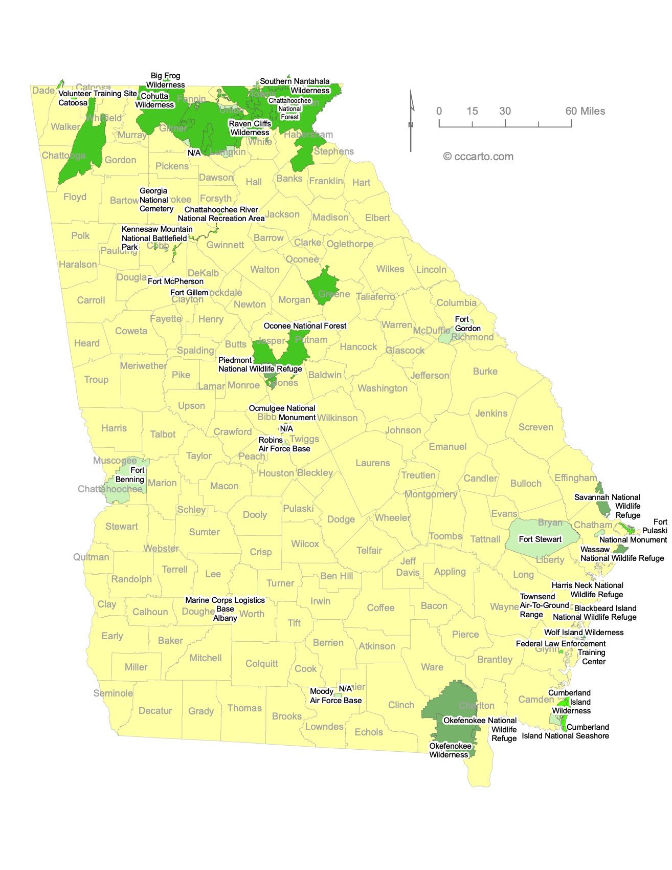
Georgia Federal Lands State Map | National Parks & Protected Areas
1. Chattahoochee National Forest
The Chattahoochee National Forest is a vast forest in northern Georgia, spanning nearly 750,000 acres across the Appalachian Mountains. It is renowned for its diverse landscapes, including rolling hills, towering hardwood forests, and clear mountain streams. Popular activities include hiking, camping, fishing, and hunting. The forest is also home to part of the Appalachian Trail, offering stunning panoramic views and scenic routes for backpackers and day hikers alike. Wildlife in the area is abundant, featuring black bears, white-tailed deer, and a variety of bird species, making it a great destination for nature lovers and outdoor enthusiasts.
2. Okefenokee National Wildlife Refuge
Okefenokee National Wildlife Refuge, located in southeastern Georgia, protects one of the largest intact freshwater ecosystems in the country, covering over 400,000 acres of the Okefenokee Swamp. The swamp is a rich ecological habitat, home to alligators, black bears, sandhill cranes, and a wide array of plant species, including cypress trees and carnivorous plants. The refuge is popular for its canoeing and kayaking routes through dark, reflective waters, offering a glimpse into the swamp’s fascinating flora and fauna. It also has historic significance, with evidence of Native American and early European settler presence. Visitors can explore its scenic drives, walking trails, and boardwalks.
3. Cumberland Island National Seashore
Cumberland Island National Seashore, the largest and southernmost barrier island in Georgia, offers a pristine and undeveloped coastline, with over 17 miles of secluded beaches, wild dunes, and dense maritime forests. The island is famous for its historical landmarks, including the ruins of Dungeness, a mansion built by the Carnegie family in the 1880s, as well as the Plum Orchard mansion, another Carnegie-era estate. Cumberland Island is also known for its population of wild horses, which roam freely across the island. The seashore offers a wide range of activities, including hiking, biking, camping, and birdwatching, while its remote location and limited visitor access preserve its tranquility and natural beauty.

Georgia Ecoregions State Map | EPA Ecological Zones
Atlantic Coastal Flatlands Section
The Atlantic Coastal Flatlands section covers the southeastern corner of Georgia and extends along the coastal areas. This ecoregion is characterized by flat, low-lying terrain with sandy soils, salt marshes, and tidal rivers. The region supports a variety of ecosystems, including maritime forests, freshwater wetlands, and estuaries that are important for migratory bird species and marine life. The climate is humid and subtropical, with warm summers and mild winters. Coastal tourism, shrimping, and fishing are key activities here, while the barrier islands in this section provide important wildlife habitats.
Blue Ridge Mountains Section
The Blue Ridge Mountains section lies in northeastern Georgia and is part of the larger Appalachian Mountain range. It is the most rugged and elevated ecoregion in the state, with dense forests, clear streams, and waterfalls. The Blue Ridge Mountains contain Georgia's highest peaks, such as Brasstown Bald, and are known for their biodiversity, including a wide variety of plant and animal species. This region experiences cooler temperatures than the rest of Georgia State due to its elevation, and it is a popular area for outdoor activities like hiking, camping, and wildlife watching. The region also plays an important role in water resource management, as it is a major source of clean drinking water for the state.
Central Ridge and Valley Section
The Central Ridge and Valley section, located in northwest Georgia, is marked by long, parallel ridges and broad valleys that were shaped by ancient geological processes. This ecoregion consists of a mix of forests, pastures, and farmlands, making it a productive agricultural area. The valleys are rich in limestone and support the growth of crops like corn and soybeans, while the ridges are typically forested. This region also has important historical and cultural significance, as it was once inhabited by Native American tribes and later became a battleground during the Civil War. The Ridge and Valley section is also known for its caves, springs, and mineral deposits.
Coastal Plains and Flatwoods, Lower Section
The Lower Coastal Plains and Flatwoods section stretches across southern Georgia State and is distinguished by its flat, sandy terrain, interspersed with pine forests and wetlands. This region is home to the iconic longleaf pine ecosystem, which once covered much of the southeastern United States but has since become rare due to logging and land conversion. The Lower Coastal Plain is a hotspot for biodiversity, supporting species like the gopher tortoise and the red-cockaded woodpecker. The region’s forests are used for timber production, while its wetlands play a crucial role in water filtration and flood control.
Coastal Plains, Middle Section
The Middle Coastal Plains region is located slightly inland from Georgia’s coastline and features gently rolling hills and broad river valleys. This ecoregion is known for its agricultural productivity, with large areas dedicated to crops like peanuts, cotton, and tobacco. The fertile soils in this region support a range of farming activities, while the natural habitats, including pine flatwoods and hardwood swamps, support a variety of wildlife. Rivers that flow through this region, such as the Ogeechee and Altamaha, provide important water sources for irrigation and transportation.
Florida Coastal Lowlands (Eastern) Section
The Florida Coastal Lowlands (Eastern) section extends into the southernmost part of Georgia State, characterized by flat, low-lying landscapes with sandy soils and a warm, humid climate. This region is largely covered by pine forests, wetlands, and small lakes, supporting industries like timber and paper production. The region’s proximity to the Gulf of Mexico and the Atlantic Ocean influences its climate and ecosystems, with large amounts of rainfall and high humidity fostering lush vegetation. Additionally, this area is important for wildlife conservation, particularly for waterfowl and other wetland species.
Northern Cumberland Plateau Section
The Northern Cumberland Plateau section occupies the far northwestern corner of Georgia State, sharing characteristics with the Appalachian Plateau. This region is composed of high ridges and steep valleys formed by erosion and tectonic activity over millions of years. The terrain is rugged, with a mix of hardwood and coniferous forests, and is known for its biodiversity. The Cumberland Plateau is home to numerous caves, rivers, and waterfalls, and the landscape supports outdoor activities such as hiking, rock climbing, and caving. It also has significant coal deposits, although mining activity in the region has decreased in recent years.
Southern Appalachian Piedmont Section
The Southern Appalachian Piedmont covers a broad swath of central Georgia State, including the state’s most populous areas such as Atlanta. This region is characterized by rolling hills, granite outcrops, and red clay soils. Historically, the Piedmont was covered by forests, but much of the land has been cleared for agriculture and urban development. Despite this, the region still supports a variety of plant and animal life, particularly in remaining forested areas and protected parks. The Piedmont is also known for its rivers, which have shaped the landscape and provide important resources for human settlement, including the Chattahoochee River and its reservoirs.
Southern Cumberland Plateau Section
The Southern Cumberland Plateau lies in the northwestern part of Georgia State and is part of the Appalachian Plateaus. This region features flat-topped mountains and deep valleys, with significant forest cover that provides habitats for various wildlife species. The Southern Cumberland Plateau is rich in biodiversity, with species adapted to the cool, moist conditions of the plateau’s forests and streams. The region is also known for its scenic landscapes, including waterfalls and caves, which attract visitors for outdoor recreation such as hiking and caving.
Southern Ridge and Valley Section
The Southern Ridge and Valley section, located in northwest Georgia State, is part of the larger Ridge and Valley province that extends through the Appalachian Mountains. This region is characterized by long, narrow ridges separated by broad valleys. The area is rich in limestone and other sedimentary rock, making it an important location for quarrying and mining. The valleys support fertile farmlands, while the ridges are often forested and provide habitat for a range of wildlife. The Ridge and Valley region also has historical significance, with many archaeological sites and Civil War battlefields scattered throughout the area.