

Arkansas State Maps | Complete Map Collection
Arkansas State Maps: Detailed Maps for Counties, Cities, Federal Areas, Physiographic & Ecoregions
Welcome to our comprehensive collection of Arkansas State Maps, meticulously curated to provide detailed, high-resolution visualizations of the state’s geography, political boundaries, and natural regions. These maps are designed for students, researchers, planners, and anyone seeking an in-depth visual reference.
- Counties and Cities: Clearly defined county boundaries and major cities for planning, education, and demographic reference.
- Federal Areas: National parks, forests, monuments, wildlife refuges, military installations, and other federally managed lands.
- Physiographic Regions: Major landforms and terrain features such as mountains, plains, valleys, plateaus, and coastal areas.
- Ecoregions: Ecological zones representing forests, grasslands, deserts, wetlands, and other biodiversity regions.

Arkansas Counties Interesting Facts
Arkansas has 75 counties, from Ozark highlands to Delta lowlands; Pulaski & Benton dominate growth.
- Number of counties: 75 — List
- First & last established: Early territorial counties; last created Cleburne (1883) — Newberry Atlas
- Highest & lowest county: Highest at Mt. Magazine (Logan); lowest Ouachita R. at LA line (Ashley) — USGS
- Most & least populated: Most: Pulaski; Least: Calhoun
- Least & most developed (proxy): Most: Pulaski; Least: Calhoun
- Most geographically diverse: Garland County (Ouachita Mtns, lakes, Hot Springs)
- Strangest-shaped county: Arkansas County (two noncontiguous lobes)
- State’s Biggest Commodity: Broilers (with rice & soybeans major). FarmFlavor 2024
- Largest Private Employer: Walmart (HQ in Bentonville)
- Top 3 Non-English Languages: Spanish, Marshallese (Austronesian), Vietnamese — DataUSA
About CCCarto – Arkansas State Maps Creator
CCCarto has been producing professional digital and GIS maps for large companies, government agencies, and educational institutions since 1988. With over 35 years of cartographic experience, our Arkansas state maps are designed to the highest standards of accuracy, clarity, and usability.
Our map collection spans counties, cities, federal lands, ecoregions, physiographic regions, topographic relief, and more — giving students, researchers, educators, planners, and curious explorers the best Arkansas state map resources available online. Every map is optimized for both screen viewing and letter-size printing.
Explore our full U.S. State Maps collection, or browse our Geology Maps, Travel Maps, and Energy Maps.
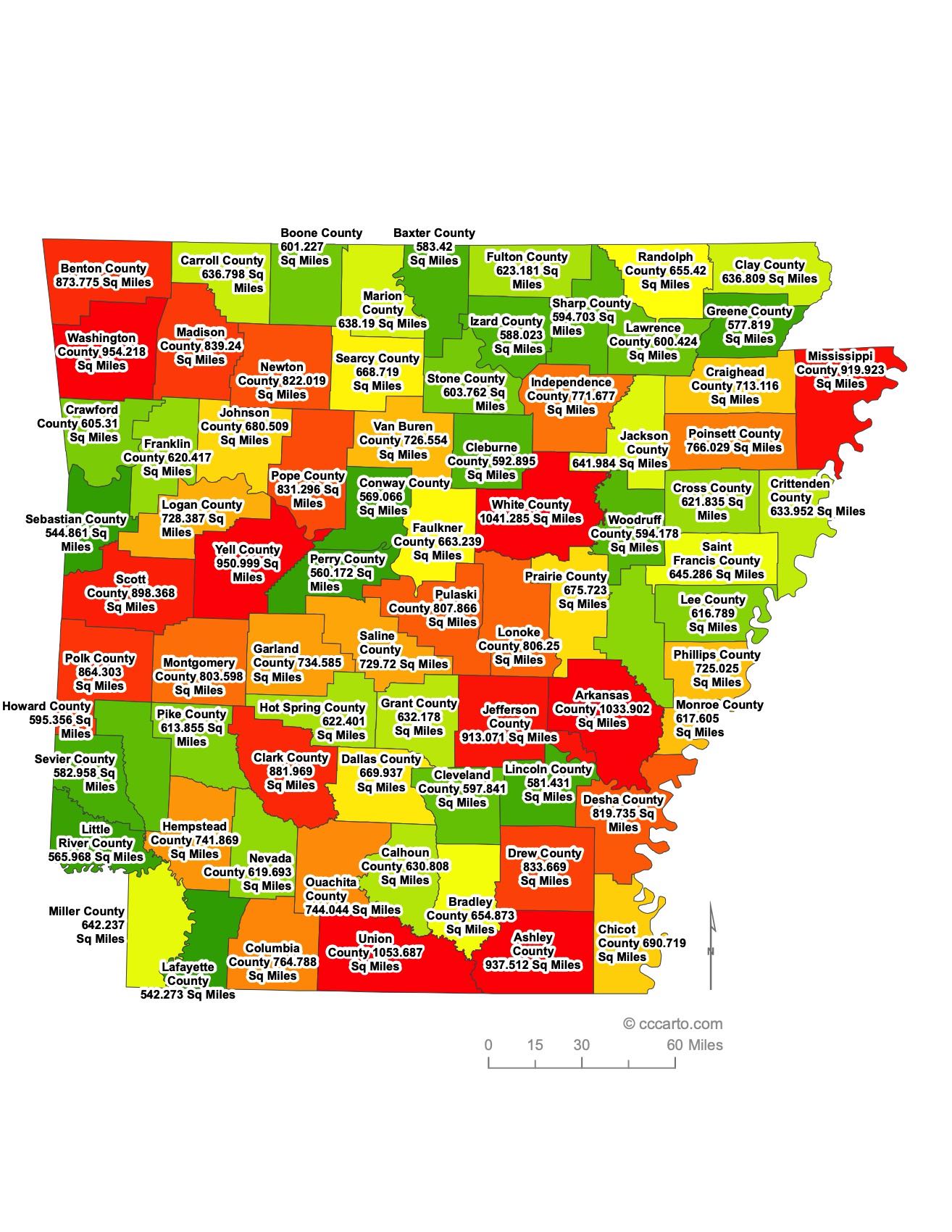
Arkansas County Sizes State Map
Smallest County in Arkansas State
Calhoun County: 629 sq miles
Largest County in Arkansas State
Union County: 1,039 sq miles
Mean and Median Area of Counties in Arkansas State
Mean Area: 664.23 sq miles
Median Area: 631 sq miles

Major Cities of Arkansas | Arkansas Cities State Map
In Arkansas State, most major cities are strategically located near rivers or historic transportation routes. These cities have historically developed as centers of commerce, transportation, and cultural exchange. Below are examples of key cities and their unique geographical and economic features:
1. River Cities
Little Rock: The largest city in Arkansas and its state capital, Little Rock is located on the Arkansas River. This central location has historically facilitated trade and transportation. Today, Little Rock is a major hub for business, government, and education. Its downtown area, with River Market District, is a popular destination for shopping, dining, and entertainment. The William J. Clinton Presidential Library and Museum is one of its most notable landmarks.
Fort Smith: Situated along the Arkansas River on the state's western border with Oklahoma, Fort Smith has been a historic gateway to the American West. Fort Smith played a crucial role during the era of westward expansion and the enforcement of law and order on the frontier. Today, Fort Smith is known for its cultural heritage, military history, and proximity to outdoor recreational areas like the Ozark National Forest.
Pine Bluff: Located along the Arkansas River in the southeastern part of the state, Pine Bluff has long been a center for agriculture, industry, and transportation. The city is known for its rich African American heritage, its contributions to the blues and jazz music scenes, and the Delta Rivers Nature Center, which showcases the area's diverse wildlife and ecosystems.
2. Historic Transportation Routes
Fayetteville: Situated in the Ozark Mountains in northwestern Arkansas, Fayetteville is known for its historical ties to the Butterfield Overland Mail route and its central role in the development of northwest Arkansas. As the home of the University of Arkansas, Fayetteville has become a center of education and culture in the state. The city has a vibrant arts scene, and the historic downtown area is a hub for dining, entertainment, and community events.
Jonesboro: Located in northeastern Arkansas, Jonesboro has historically been a transportation hub for railroads and agriculture. The city is known for its role in the Arkansas Delta region, providing a gateway to the rich farmland of the Mississippi Alluvial Plain. Jonesboro is home to Arkansas State University, which brings a youthful energy and educational focus to the area.
Texarkana: Straddling the border between Arkansas and Texas, Texarkana has long been a vital stop on important trade routes. With one part of the city in Arkansas and the other in Texas, Texarkana plays a unique role in fostering interstate commerce. Its location along major railroad lines and highways has made it a critical point for logistics and trade in the region.
3. Other Key Cities
Springdale: Springdale is located in the northwest corner of Arkansas and is part of the larger Fayetteville-Springdale-Rogers metropolitan area. The city is a major center for the poultry industry, with Tyson Foods headquartered here. Springdale is also known for its cultural diversity and rapidly growing population, thanks in part to the region's booming economy.
Bentonville: Best known as the headquarters of Walmart, the world's largest retailer, Bentonville has grown from a small town to an internationally recognized city. The presence of Walmart has spurred economic development, bringing in other businesses and cultural institutions like the Crystal Bridges Museum of American Art. Bentonville's historic downtown and its surrounding areas are experiencing a renaissance, with upscale dining, shopping, and cultural events.
Conway: Located just north of Little Rock, Conway is known as the "City of Colleges," home to three institutions of higher education: the University of Central Arkansas, Hendrix College, and Central Baptist College. Conway has experienced rapid growth due to its focus on education, technology, and healthcare. The city's thriving downtown and emphasis on community events have made it a popular place to live and work.
Rogers: Also part of the fast-growing northwest Arkansas region, Rogers is known for its scenic views of the Ozark Mountains and proximity to Beaver Lake. The city's economy is closely tied to the retail and service industries due to its proximity to Walmart's headquarters in Bentonville. Rogers has a bustling historic downtown area and offers many outdoor recreational opportunities, including hiking, fishing, and boating.
Hot Springs: Nestled in the Ouachita Mountains, Hot Springs is famous for its natural thermal springs, which have been attracting visitors for centuries. The city was one of the first federally protected areas in the U.S. and later became Hot Springs National Park. Hot Springs has a rich history as a health resort and later as a gambling and entertainment destination. Today, it is a popular tourist spot with attractions like Bathhouse Row, Oaklawn Racing Casino Resort, and its proximity to lakes and forests.
North Little Rock: Situated directly across the Arkansas River from Little Rock, North Little Rock is a key part of the Little Rock metropolitan area. The city is home to the Verizon Arena, a major venue for concerts and sporting events, as well as the Arkansas Inland Maritime Museum. North Little Rock offers a mix of suburban life and access to the vibrant city culture of Little Rock, while also having its own distinct parks, historic districts, and shopping areas.
Arkansas Topographic State Map | Shaded Relief


Arkansas offers a diverse range of terrains, shaped by its unique geology and natural features. From the Ouachita Mountains to the fertile plains, the state provides a rich tapestry of landscapes, each contributing to its natural beauty and recreational opportunities. Whether you're exploring mountains, forests, rivers, or plains, Arkansas has a wide variety of topographic features to discover.
1. Ouachita Mountains
The Ouachita Mountains, located in the western part of the state, are one of the few mountain ranges in North America that run east to west rather than north to south. This region features rolling hills, steep valleys, and some of the highest elevations in Arkansas, including Rich Mountain and Mount Magazine. The mountains are known for their dense forests, scenic drives, and recreational opportunities like hiking, mountain biking, and camping. The Ouachitas also contain many rivers and lakes, including Lake Ouachita, one of the cleanest lakes in the U.S.
2. Mississippi Alluvial Plain
Stretching along the eastern border of Arkansas, the Mississippi Alluvial Plain, also known as the Delta, is characterized by flat, fertile soils that have supported agriculture for centuries. This region is shaped by the meandering Mississippi River and its tributaries, creating a landscape of wetlands, floodplains, and rich farmland. The Delta is a significant area for row crop farming, especially rice, soybeans, and cotton. The wetlands also serve as critical habitats for migratory birds and other wildlife.
3. Arkansas River Valley
The Arkansas River Valley separates the Ouachita and Ozark Mountains and runs through the central part of the state. This region features flatlands mixed with rolling hills and rugged terrain. The Arkansas River itself is a defining feature, providing opportunities for fishing, boating, and other water-based recreation. Mount Nebo, Petit Jean Mountain, and Mount Magazine (the highest point in Arkansas at 2,753 feet) are prominent landmarks in the valley, offering panoramic views, hiking trails, and camping spots.
4. Ozark Mountains
The Ozark Mountains, also called the Ozark Plateaus, cover much of northern Arkansas and are known for their steep, forested hills, deep valleys, and fast-flowing rivers. The Ozarks offer a rugged landscape with limestone bluffs, caves, springs, and waterfalls. Popular destinations include the Buffalo National River, which flows through the heart of the Ozarks and offers some of the most scenic canoeing and hiking in the region. The Ozarks are also home to the Ozark National Forest, which provides opportunities for hiking, camping, and wildlife observation.
5. Crowley’s Ridge
Crowley’s Ridge is a unique geological formation that rises dramatically above the surrounding flat plains of the Mississippi Delta. This narrow, low ridge runs from southeastern Missouri into northeastern Arkansas and is characterized by its rich, loess (wind-blown) soils. Crowley’s Ridge is heavily forested with hardwoods, making it a striking contrast to the surrounding farmland. Several state parks, such as Village Creek State Park, are located along the ridge, offering hiking trails and scenic views.
6. Gulf Coastal Plain
Covering much of southern Arkansas, the Gulf Coastal Plain is a region of gently rolling hills and flatlands. This area is known for its extensive pine forests, which are a major part of the state's timber industry. The Gulf Coastal Plain also contains rich oil and gas deposits, which have been economically significant for the region. Recreational opportunities in the region include fishing, hunting, and camping in areas such as Millwood Lake and White Oak Lake.
7. Spring River and White River Valleys
These river valleys, located in the northeastern and north-central parts of the state, are known for their clear, spring-fed waters and scenic landscapes. The White River, in particular, is famous for its trout fishing, especially in the tailwaters below Bull Shoals Dam. The Spring River, with its swift current and cold, clear water, is a popular destination for floating and fishing. These river valleys provide lush, green scenery and are surrounded by the rugged hills of the Ozarks.

Arkansas Federal Lands State Map | National Parks & Protected Areas
1. Hot Springs National Park
Hot Springs National Park is Arkansas' most visited national park, known for its thermal springs and historical bathhouses. Located in the Ouachita Mountains, the park offers a combination of health tourism and scenic beauty. Visitors can enjoy hiking trails, scenic drives, and explore the historic Bathhouse Row, a symbol of the park's long history of spa tourism.
2. Buffalo National River
The Buffalo National River, one of the first national rivers to be designated in the United States, stretches for 135 miles through the Ozark Mountains. The river offers pristine waters, dramatic bluffs, and diverse ecosystems. Visitors can enjoy canoeing, kayaking, fishing, hiking, and camping along the riverbanks. The area is also home to elk herds and a variety of bird species.
3. Ouachita National Forest
Spanning over 1.8 million acres in western Arkansas and eastern Oklahoma, the Ouachita National Forest is one of the oldest national forests in the southern U.S. It is known for its rugged beauty, diverse wildlife, and vast recreational opportunities. Popular activities include hiking, mountain biking, horseback riding, and camping. The forest also contains the Ouachita National Recreation Trail, a 223-mile-long trail that provides stunning views of the region’s mountains and valleys.
4. Ozark-St. Francis National Forest
The Ozark-St. Francis National Forest is split into two separate areas in Arkansas. The Ozark National Forest covers much of the Ozark Mountains, offering trails, scenic overlooks, and camping opportunities. Highlights include the Mulberry River, Blanchard Springs Caverns, and Mount Magazine, the highest point in Arkansas. The St. Francis National Forest, though smaller, features wetlands, hardwood forests, and opportunities for fishing and hunting along the Mississippi River.
5. Pea Ridge National Military Park
Pea Ridge National Military Park preserves the site of the Civil War Battle of Pea Ridge, which was a pivotal battle in the control of Missouri. This 4,300-acre park offers historical interpretation, driving tours of the battlefield, and walking trails that take visitors through significant locations where the battle took place. It's a key historical site for Civil War enthusiasts and history buffs.
6. White River National Wildlife Refuge
The White River National Wildlife Refuge is located along the lower White River in eastern Arkansas. It is one of the largest remaining bottomland hardwood forests in the Mississippi River Valley and provides critical habitat for migratory birds, black bears, and other wildlife. The refuge offers opportunities for hunting, fishing, boating, and wildlife observation, making it a popular destination for outdoor enthusiasts.
7. Fort Smith National Historic Site
Fort Smith National Historic Site preserves the remains of two frontier forts and a federal court that was essential in the development of law and order in the Old West. Visitors can explore the historic courthouse, jail, and the gallows where federal executions took place. The site also tells the story of the U.S. Marshals and their role in taming the western frontier.

Arkansas Ecoregions State Map | EPA Ecological Zones
Arkansas Valley Section
The Arkansas Valley ecoregion lies between the Ouachita Mountains and the Ozark Plateaus, featuring a mixture of forests, prairies, and agricultural land. This region is known for its fertile soils and is home to a variety of crops, as well as livestock farming. The Arkansas River flows through this area, providing vital water resources for agriculture and industry. The valley also supports diverse wildlife, including deer, turkey, and migratory birds.
Boston Mountains Section
The Boston Mountains, part of the Ozark Plateaus, are characterized by steep, rugged terrain with deep valleys and forested hills. The area is known for its hardwood forests, including oak, hickory, and pine trees. The region provides habitat for a variety of wildlife, including black bears, white-tailed deer, and bobcats. The Boston Mountains are a popular destination for outdoor recreation, offering hiking, camping, and scenic vistas, especially along the Ozark Highlands Trail.
Mississippi Alluvial Plain (Delta) Section
Also known as the Arkansas Delta, the Mississippi Alluvial Plain is a flat, fertile region that stretches along the eastern border of the state. This ecoregion is shaped by centuries of river flooding and is home to some of the most productive agricultural land in the United States. Crops like rice, soybeans, cotton, and corn dominate the landscape. The region also contains significant wetlands and bottomland hardwood forests, providing critical habitat for waterfowl and other wildlife. Wildlife refuges and conservation areas preserve some of the remaining natural landscapes.
Ouachita Mountains Section
The Ouachita Mountains ecoregion spans much of western Arkansas and is one of the only major mountain ranges in the U.S. that runs east to west. The rugged terrain consists of steep ridges, valleys, and densely forested areas. The Ouachita National Forest covers a large portion of this region, offering recreational opportunities such as hiking, fishing, and camping. Pine and oak trees dominate the forests, and the region is home to a variety of wildlife, including black bears, elk, and a range of bird species.
Ozark Highlands Section
The Ozark Highlands, part of the larger Ozark Plateau, are located in the northern part of Arkansas. This region is marked by its rolling hills, clear streams, and karst topography, which includes caves, sinkholes, and springs. The area is known for its scenic beauty, with the Buffalo National River being a major draw for canoeing, fishing, and hiking. The forests in this region are dominated by oak and hickory trees, and the region is home to diverse wildlife, including bats, deer, and wild turkeys.
Springfield-Salem Plateaus Section
The Springfield-Salem Plateaus are part of the Ozark Plateaus ecoregion in north-central Arkansas. This area is characterized by relatively flat to gently rolling hills, interspersed with steep valleys and ridges. The region's geology is largely limestone and dolomite, leading to the formation of caves, sinkholes, and underground streams. Agriculture, particularly livestock grazing, plays a significant role in this ecoregion, along with forestry and outdoor recreation. The karst topography provides habitats for rare species and a diversity of plant life.
West Gulf Coastal Plain Section
The West Gulf Coastal Plain covers much of southern Arkansas and is characterized by gently rolling hills, flat plains, and extensive pine forests. This ecoregion is part of a larger area that extends into Texas and Louisiana. The timber industry is a major economic activity here, with pine plantations covering large swaths of land. The region also contains wetlands and bottomland hardwood forests, which provide critical habitats for wildlife, particularly migratory birds and waterfowl. The area supports agriculture, including crops like soybeans, cotton, and timber production.
East Gulf Coastal Plain Section
Located in the southeastern part of the state, the East Gulf Coastal Plain is a low-lying area that transitions into the Mississippi Alluvial Plain. The region is characterized by its forests, swamps, and agricultural lands. The soil in this area is fertile and supports agriculture, with rice and soybeans being dominant crops. The wetlands and swamps in this ecoregion are home to various species of waterfowl, alligators, and other wildlife, making it a significant area for biodiversity conservation and outdoor recreation like hunting and birdwatching.

Arkansas Physiographic Regions State Map
1. Coastal Plain - East Gulf Coastal Plain
The East Gulf Coastal Plain, located in southeastern Arkansas, is a flat, low-lying region that is primarily composed of river valleys, wetlands, and swamps. This area is known for its fertile soils, which support a thriving agricultural economy, particularly in the production of rice, soybeans, and cotton. The East Gulf Coastal Plain also contains important wetland habitats that are critical for wildlife, particularly waterfowl and migratory birds.
2. Coastal Plain - Mississippi Alluvial Plain
The Mississippi Alluvial Plain, also known as the Arkansas Delta, is one of the most significant physiographic regions in Arkansas. Stretching along the eastern part of the state, this flat plain is shaped by centuries of flooding from the Mississippi River. It is a major agricultural hub, known for the production of rice, soybeans, corn, and cotton. The region also supports wetland habitats and is critical for both biodiversity and waterfowl migration, with large areas designated as wildlife refuges.
3. Coastal Plain - West Gulf Coastal Plain
The West Gulf Coastal Plain covers the southern and southwestern portions of Arkansas. It is characterized by gently rolling hills and extensive pine forests, which are important for the timber industry. This region has rich natural resources, including oil and gas reserves, and is known for its timber and agricultural production. The West Gulf Coastal Plain is also home to many lakes and rivers that offer recreational opportunities such as fishing, boating, and hunting.
4. Ouachita Province - Arkansas Valley
The Arkansas Valley lies between the Ouachita Mountains and the Ozark Plateaus and features a combination of rolling plains, steep ridges, and broad valleys. This region has a diverse landscape with forests, agricultural land, and small mountain ranges. The Arkansas River runs through the valley, providing an important waterway for transportation and irrigation. The Arkansas Valley is also known for its rich biodiversity and is home to Mount Magazine, the highest point in Arkansas.
5. Ouachita Province - Ouachita Mountains
The Ouachita Mountains are one of the most prominent physiographic regions in Arkansas, stretching across the western part of the state. This east-to-west running mountain range is characterized by rugged terrain, deep valleys, and forested hills. The Ouachitas are part of the larger U.S. Interior Highlands and are known for their unique geological formations, which include folded mountains and ancient rock strata. The region is heavily forested, with pine and hardwood trees, and is popular for outdoor activities such as hiking, camping, and fishing in the many rivers and lakes found here.
6. Ozark Plateaus - Boston Mountains
The Boston Mountains are the highest and most rugged part of the Ozark Plateaus, located in the northern portion of Arkansas. This area features steep ridges, deep valleys, and heavily forested terrain. The Boston Mountains are known for their scenic beauty, clear streams, and natural springs. They are a key destination for outdoor recreation, with numerous hiking trails, including the Ozark Highlands Trail. The region is also home to the Buffalo National River, one of the first national rivers designated in the United States.
7. Ozark Plateaus - Springfield-Salem Plateaus
The Springfield-Salem Plateaus are part of the larger Ozark Plateaus region, located in north-central Arkansas. This area features gently rolling hills, interspersed with steep ridges and valleys. The region is characterized by its karst topography, which includes caves, sinkholes, and underground streams. The Springfield-Salem Plateaus are a mix of agricultural land and forests, with cattle farming and timber production playing significant roles in the economy. The region also offers outdoor recreational activities like spelunking, hiking, and fishing in the numerous rivers and streams.