

Utah State Maps | Complete Map Collection
Utah State Maps: Detailed Maps for Counties, Cities, Federal Areas, Physiographic & Ecoregions
Welcome to our comprehensive collection of Utah State Maps, meticulously curated to provide detailed, high-resolution visualizations of the state’s geography, political boundaries, and natural regions. These maps are designed for students, researchers, planners, and anyone seeking an in-depth visual reference.
- Counties and Cities: Clearly defined county boundaries and major cities for planning, education, and demographic reference.
- Federal Areas: National parks, forests, monuments, wildlife refuges, military installations, and other federally managed lands.
- Physiographic Regions: Major landforms and terrain features such as mountains, plains, valleys, plateaus, and coastal areas.
- Ecoregions: Ecological zones representing forests, grasslands, deserts, wetlands, and other biodiversity regions.
Map Profile
- Format: JPEG
- Color: RGB
- Resolution: ~72 DPI
- Typical image size: ~1300 × 1700 px
- Paper size: Letter (8.5 × 11 inches)
- Layouts: Portrait and Landscape
- File size: ~100–500 KB
Print tip: In your print dialog select Letter (8.5×11), choose Portrait or Landscape, and use Fit to Page (or Scale - to fit).

Utah Counties Interesting Facts
Utah’s counties combine PLSS-aligned lines with edges on the Great Salt Lake, high Uinta & Wasatch ranges, and canyonlands of the Colorado Plateau.
- Number of counties: 29. Utah counties map · Utah Association of Counties
- First & last established county: Territorial counties began in 1850; newest is Daggett (1918). Source: Newberry Atlas
- How borders are set: PLSS grid prevails; major natural edges include the Great Salt Lake & Uinta/Wasatch divides. See BLM PLSS.
- Highest & lowest county (elev.): Highest at Kings Peak in Duchesne County; lowest at Beaver Dam Wash in Washington County. Source: Utah.gov Quick Facts.
- Most & least populated county: Most: Salt Lake County. Least: Daggett County.
- Least & most developed (proxy): Most developed: Salt Lake; least: Daggett.
- Most geographically diverse county: Salt Lake County (Wasatch peaks, Jordan River valley, Great Salt Lake shoreline; see lake overview).
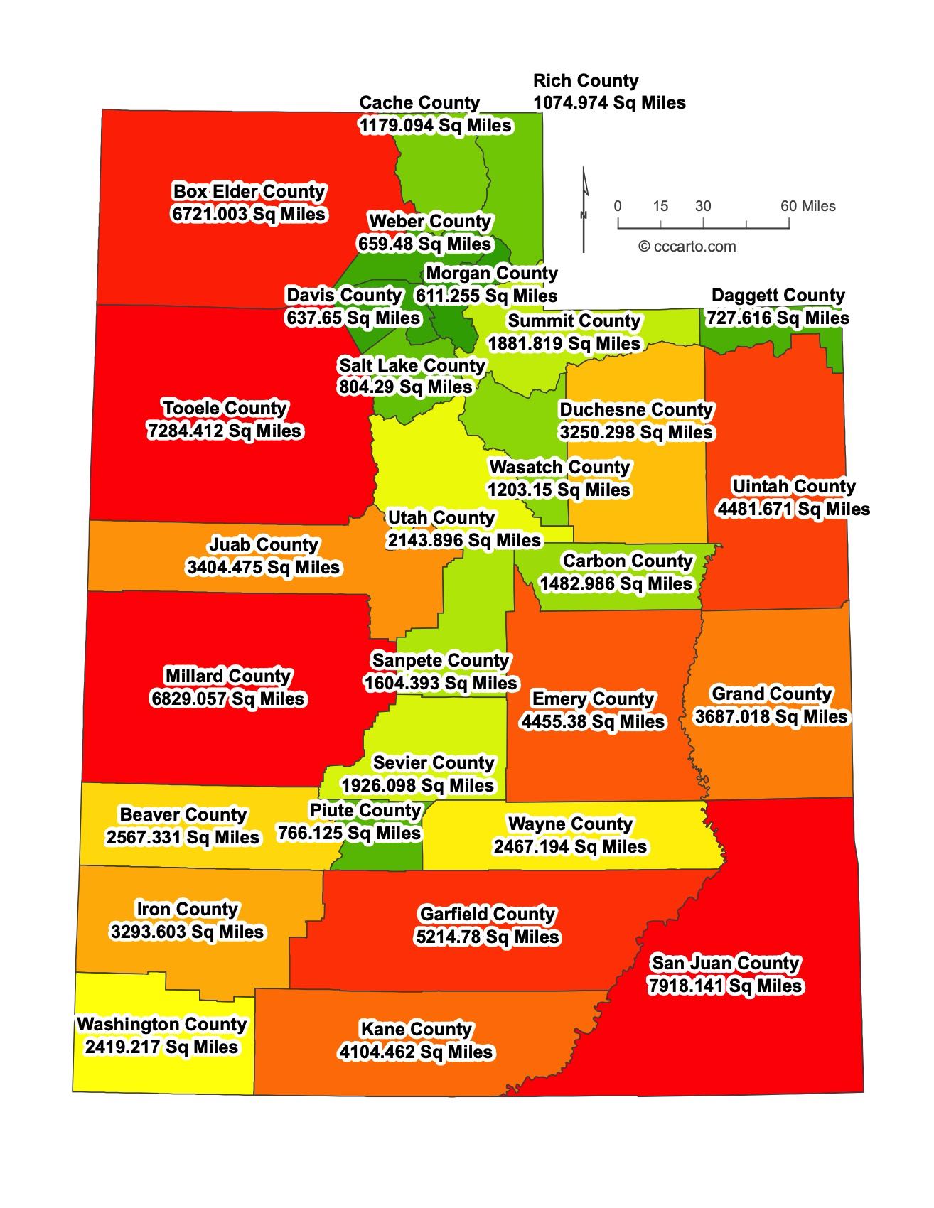
Utah County Sizes State Map
Smallest County in Utah State
Daggett County: 728 sq miles
Largest County in Utah State
San Juan County: 7,918 sq miles
Mean and Median Area of Counties in Utah State
Mean Area: 2,221.64 sq miles
Median Area: 1,969.00 sq miles

Major Cities of Utah | Utah Cities State Map
In Utah, most major cities are located near water sources or along historic transportation routes.
1. Salt Lake City:
The capital and largest city, Salt Lake City, is located near the Great Salt Lake and was a major settlement for Mormon pioneers. It is the economic and cultural hub of Utah.
2. Provo:
Located along the Wasatch Front, Provo is known for its proximity to the mountains, Brigham Young University, and its role in Utah’s economy and education.
3. St. George:
A southern Utah city near the Arizona border, St. George is famous for its red rock landscapes, outdoor recreation, and proximity to Zion National Park.
4. Moab:
Moab, located in southeastern Utah, is a gateway to Arches and Canyonlands National Parks and is renowned for its stunning desert landscapes and adventure tourism.
5. Logan:
Logan is a northern Utah city, home to Utah State University. It is known for its agricultural roots and picturesque setting in Cache Valley.
6. Brigham City:
Brigham City is located at the mouth of Box Elder Canyon and is known for its peach orchards and the Bear River Migratory Bird Refuge.
7. Ogden:
Ogden, located north of Salt Lake City, is historically known as a major railway hub and is now a center for outdoor recreation with access to the Wasatch Mountains.
8. Orem:
Orem, located just north of Provo, is a rapidly growing city along the Wasatch Front, known for its family-friendly atmosphere and proximity to Utah Valley University.
9. Monticello:
Monticello, located in southeastern Utah, serves as a gateway to Canyonlands National Park and the nearby Abajo Mountains.
10. Cedar City:
Cedar City is known for its proximity to Cedar Breaks National Monument and its renowned Shakespeare Festival, held annually at Southern Utah University.
11. Richfield:
Richfield, located in central Utah, serves as a regional hub for the agricultural community and is a gateway to several national parks and recreational areas.
12. Wendover:
Wendover, located on the Utah-Nevada border, is known for its casinos and its proximity to the Bonneville Salt Flats, a famous site for land speed records.
13. Nephi:
Nephi, located along Interstate 15 in central Utah, is known for its small-town charm and is a stopping point for travelers heading through the state.
14. Green River:
Green River is situated along the Green River in eastern Utah and is known for its melons and as a gateway to the surrounding canyons and wilderness areas.
15. Vernal:
Vernal, located in northeastern Utah, is known for its proximity to Dinosaur National Monument and as a center for the state's energy industry.
16. Panguitch:
Panguitch is a small town in southern Utah known for its historic downtown and proximity to Bryce Canyon National Park and other scenic areas.

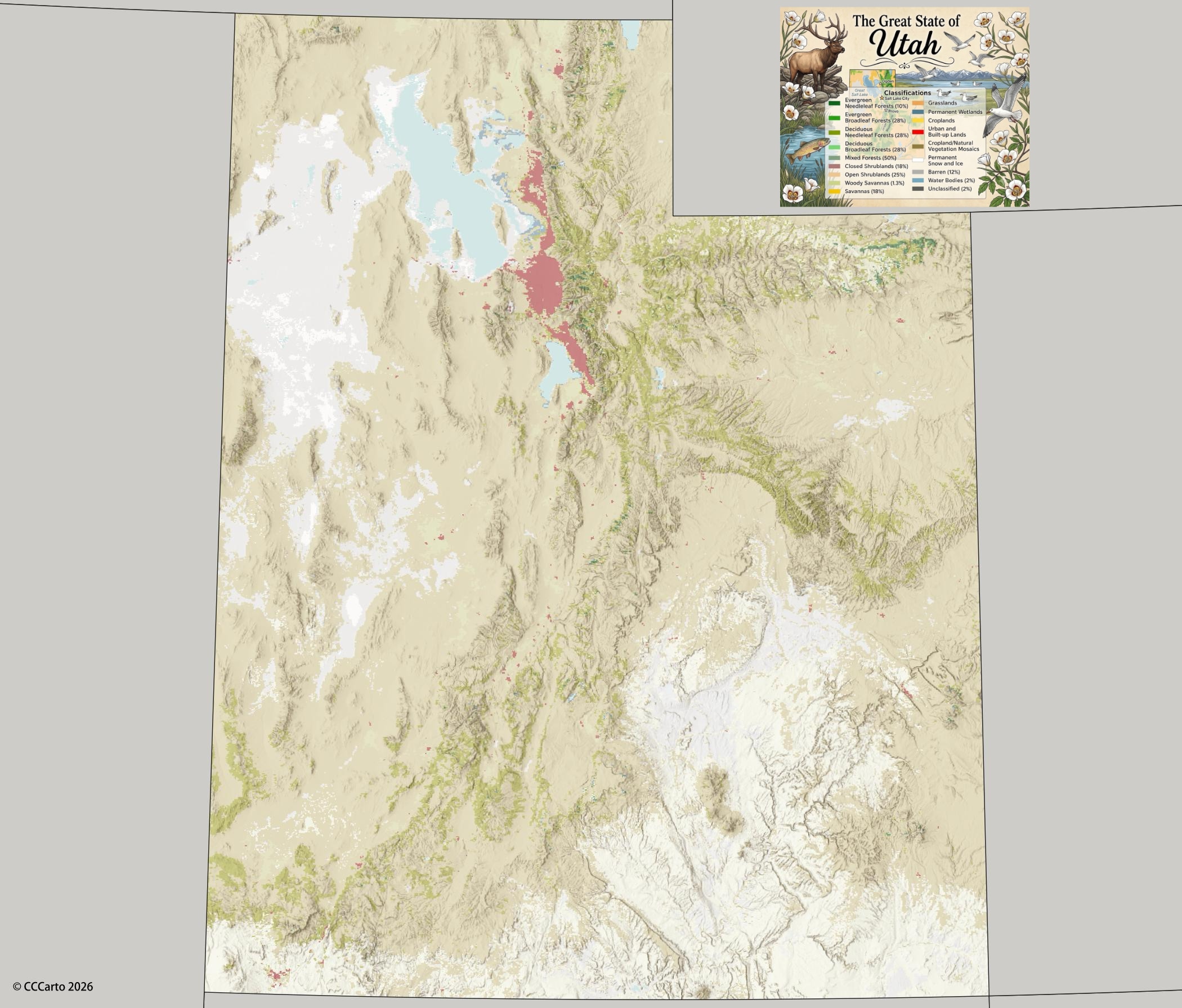
Utah Topographic State Map | Shaded Relief
Utah is a land of stunning geographical diversity, featuring rugged mountains, deep canyons, and expansive desert basins.
1. Colorado Plateau:
This region includes world-renowned landscapes such as Arches National Park, Bryce Canyon, and Zion National Park. It is a high desert area that features dramatic rock formations, deep canyons, and towering mesas.
2. Basin and Range:
Characterized by its alternating mountain ranges and desert valleys, the Basin and Range Province covers much of western Utah. Notable landscapes include the Great Salt Lake Desert and the Bonneville Salt Flats.
3. Middle Rocky Mountains:
This region includes the Wasatch Range, which offers some of the best skiing and hiking in the state. The mountains are known for their sharp peaks, alpine lakes, and significant snowfall.
4. Uinta Mountains:
The Uinta Mountains, located in northeastern Utah, are the highest east-west trending mountain range in the contiguous United States. Kings Peak, Utah's highest point, is located here at 13,528 feet.
5. Great Salt Lake:
The Great Salt Lake is the largest saltwater lake in the Western Hemisphere. Its shallow waters are a remnant of the ancient Lake Bonneville and create a unique ecosystem for migratory birds and other wildlife.
6. Escalante Grand Staircase:
The Escalante Grand Staircase is a geological marvel that showcases a series of massive, colorful cliffs that rise in steps from the Grand Canyon up through Bryce Canyon. This region features rugged terrain, slot canyons, and striking desert landscapes.
7. San Rafael Swell:
The San Rafael Swell is a large, uplifted area of desert terrain featuring a mix of deep canyons, towering mesas, and sheer cliffs. It is a popular area for hiking, off-roading, and exploring ancient rock art.
8. Utah Valley:
Utah Valley, located in the central part of the state, is a fertile lowland surrounded by the Wasatch Mountains to the east. The valley is home to Utah Lake, one of the largest freshwater lakes in the state.
9. Parowan Gap:
Parowan Gap is a natural passageway through the mountains of southern Utah, famous for its well-preserved petroglyphs. The unique geology of this area has created fascinating rock formations and cultural significance.
10. Bonneville Salt Flats:
These expansive salt flats, located in western Utah near the Nevada border, are a remnant of ancient Lake Bonneville. The Bonneville Salt Flats are famous for land speed records and provide a surreal, flat landscape that stretches for miles.
11. Bear River Range:
Part of the Middle Rocky Mountains, the Bear River Range in northern Utah features densely forested slopes, alpine meadows, and lakes. It is popular for both winter sports and summer hiking and camping.
12. Monument Valley:
Monument Valley, located on the Utah-Arizona border, is known for its towering sandstone buttes and dramatic desert landscapes. It is one of the most iconic locations in the American West and a popular filming location for movies.

Utah Federal Lands State Map | National Parks & Protected Areas
1. Zion National Park
Zion is known for its towering cliffs, narrow slot canyons, and unique desert flora and fauna. It is Utah’s first national park and offers breathtaking landscapes and diverse hiking opportunities, including the famous Angels Landing and The Narrows.
2. Arches National Park
Featuring over 2,000 natural sandstone arches, Arches National Park is a geological wonder. Delicate Arch is one of the most iconic natural landmarks in the United States, and the park offers numerous trails to explore its otherworldly rock formations.
3. Canyonlands National Park
Canyonlands preserves a vast landscape of canyons, mesas, and buttes formed by the Colorado River. The park is divided into four districts: Island in the Sky, The Needles, The Maze, and the rivers, each offering unique landscapes and outdoor activities.
4. Glen Canyon National Recreation Area
Glen Canyon NRA is home to Lake Powell, a large reservoir that offers boating, fishing, and hiking opportunities. The surrounding red rock canyons make it a visually stunning area, and it also features Rainbow Bridge, one of the world’s largest natural bridges.
5. Natural Bridges National Monument
Natural Bridges NM features three large natural stone bridges formed by the erosive forces of water over millions of years. The park offers scenic drives, hiking trails, and excellent stargazing opportunities, as it is one of the world’s designated Dark Sky Parks.
6. Hovenweep National Monument
Hovenweep NM is home to six groups of Ancestral Puebloan villages, featuring stone towers built between A.D. 1200 and 1300. It offers a glimpse into the history and culture of the ancient inhabitants of the Four Corners region.
7. Manti-La Sal National Forest
Manti-La Sal NF covers a large area in central and southeastern Utah, offering a mix of alpine and desert environments. It is popular for camping, hiking, and off-roading, with scenic drives through forested mountains and red rock deserts.
8. Grand Staircase-Escalante National Monument
Grand Staircase-Escalante NM is a vast, rugged region of slot canyons, cliffs, and plateaus. It is one of the most remote areas in Utah, making it perfect for exploration and discovery. The monument is known for its rich paleontological resources and dramatic landscapes.
9. Dugway Proving Ground
Dugway Proving Ground is a U.S. Army facility in western Utah used for testing biological and chemical weapons. While it is not a public recreational area, it is notable for its size and history related to defense research and testing.
10. Wasatch National Forest
Wasatch NF, part of the Uinta-Wasatch-Cache National Forest, stretches along the Wasatch Range, offering numerous recreational opportunities, including hiking, camping, and skiing. The forest provides scenic drives and access to wilderness areas.
11. Uinta National Forest
Also part of the Uinta-Wasatch-Cache NF, Uinta NF is known for its lush forests, high mountain lakes, and extensive trail systems. It is popular for both summer and winter activities, including fishing, hiking, and snowmobiling.
12. Dinosaur National Monument
Dinosaur NM straddles the Utah-Colorado border and is famous for its dinosaur fossils, many of which are visible at the Quarry Exhibit Hall. In addition to paleontological attractions, the park offers dramatic canyon scenery and river rafting on the Green and Yampa Rivers.
13. Ouray National Wildlife Refuge
Ouray NWR is located along the Green River and serves as a critical habitat for migratory birds and other wildlife. It provides opportunities for birdwatching, wildlife observation, and nature photography.
14. Fishlake National Forest
Fishlake NF is known for its beautiful aspen forests and high mountain terrain, including Fish Lake, Utah’s largest natural mountain lake. The forest is a haven for camping, fishing, hiking, and exploring the stunning fall foliage.
15. Bryce Canyon National Park
Bryce Canyon NP is famous for its distinctive red rock hoodoos, spire-shaped rock formations. The park’s natural amphitheaters, scenic overlooks, and hiking trails provide some of the most unique landscapes in the world.
16. Dixie National Forest
Dixie NF spans southern Utah and features dramatic red rock cliffs, alpine forests, and desert landscapes. The forest offers numerous recreational opportunities, including hiking, camping, and scenic drives through diverse ecosystems.
17. Manti National Forest
Part of Manti-La Sal NF, Manti NF is known for its rugged terrain, deep canyons, and forested mountain landscapes. The forest is a popular destination for hunting, camping, and off-road vehicle use.
18. Flaming Gorge National Recreation Area
Flaming Gorge NRA, centered around Flaming Gorge Reservoir, offers boating, fishing, and hiking in an area surrounded by colorful cliffs and rugged landscapes. The area is also known for its excellent trout fishing and scenic drives.
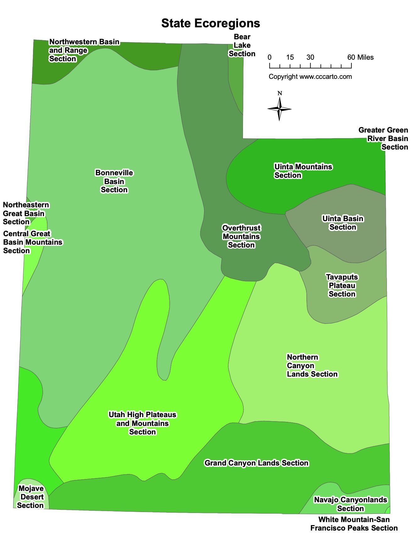
Utah Ecoregions State Map | EPA Ecological Zones
Basin And Range, Great Basin
This ecoregion covers the western part of the state and features arid valleys, low mountain ranges, and salt flats. It includes the Bonneville Salt Flats and the Great Salt Lake Desert, with sparse vegetation and unique desert wildlife.
Colorado Plateaus, Canyon Lands
Famous for its colorful cliffs, deep canyons, and unique desert ecosystems, the Canyon Lands region is home to iconic national parks like Arches, Canyonlands, and Capitol Reef. The region's red rock formations, slot canyons, and high desert plateaus define its landscape.
Colorado Plateaus, High Plateaus Of Utah
The high plateaus, including the Aquarius Plateau, are the highest plateaus in North America. This region contains forests, grasslands, and volcanic formations, offering diverse ecosystems and important habitats for wildlife.
Colorado Plateaus, Grand Canyon
This section includes the southern tip of Utah, bordering the Grand Canyon. It is characterized by its dramatic cliffs and canyons, similar to those found in nearby Zion and Bryce Canyon National Parks.
Colorado Plateaus, Navajo
The Navajo section is located in southeastern Utah, stretching into Arizona. It is known for its sandstone formations, including Monument Valley, and is home to significant cultural and archaeological sites.
Colorado Plateaus, Uinta Basin
The Uinta Basin in northeastern Utah is a semi-arid region known for its oil and gas reserves. The region is also famous for its dinosaur fossils, especially in Dinosaur National Monument.
Columbia Plateau, Snake River Plain
This region covers part of the far northern part of Utah and extends into Idaho. The Snake River Plain is characterized by volcanic features, fertile soils, and vast agricultural landscapes.
Middle Rocky Mountains
The Middle Rocky Mountains ecoregion includes the Wasatch and Uinta Mountain ranges. It is home to alpine meadows, forested slopes, and Utah's highest peaks. This area is important for outdoor recreation, including skiing, hiking, and wildlife conservation.
Wyoming Basin
The Wyoming Basin extends into northeastern Utah and is characterized by its high plains, sagebrush steppe, and rolling hills. It is a key region for livestock grazing and energy development, with unique plant and animal species adapted to the arid environment.
Bear Lake Section
This section straddles the Utah-Idaho border and includes Bear Lake, a large natural lake known for its turquoise blue water. The region supports diverse aquatic ecosystems and is popular for fishing and recreation.
Bonneville Basin Section
The Bonneville Basin is the remnant of ancient Lake Bonneville, a vast prehistoric lake. The region now includes the Great Salt Lake and surrounding salt flats, with unique ecosystems adapted to the saline environment.
Central Great Basin Mountains Section
Located in western Utah, this section features mountain ranges that rise above the desert valleys. The region supports a variety of plant communities, including sagebrush, pinyon-juniper woodlands, and isolated alpine environments.
Greater Green River Basin Section
This section extends into northeastern Utah and is part of the larger Green River Basin, an area known for its fossil deposits and energy resources. The basin supports sagebrush ecosystems and critical habitats for desert wildlife.
Mojave Desert Section
The southwestern corner of Utah is part of the Mojave Desert, a hot and arid region characterized by its desert vegetation, including Joshua trees and creosote bush. This region is home to unique plant and animal species adapted to the harsh environment.
Navajo Canyonlands Section
This section, located in southern Utah, includes rugged canyon landscapes, mesas, and plateaus. The Navajo Canyonlands are known for their stark beauty and serve as an important cultural area for Native American history.
Northeastern Great Basin Section
Covering parts of northern Utah, this section consists of dry valleys and isolated mountain ranges. It includes habitats that are important for migratory birds and other desert wildlife.
Northern Canyon Lands Section
The Northern Canyon Lands feature deep canyons and rocky plateaus, including sections of the Green River and Colorado River. This region is known for its spectacular landscapes and recreational opportunities such as river rafting and hiking.
Northwestern Basin and Range Section
This section of Utah is dominated by desert basins and low mountain ranges. The arid environment is home to sagebrush, juniper, and salt-tolerant plants, and is a critical habitat for desert wildlife.
Overthrust Mountains Section
This section covers parts of northeastern Utah and southwestern Wyoming. The region is known for its folded and faulted mountain ranges, rich in geological history, and is important for energy extraction and grazing.
Southeastern Great Basin Section
Located in southwestern Utah, this section includes arid valleys, rugged mountains, and important ecological zones for desert plants and animals. The region's desert environments provide habitat for species such as desert tortoises and coyotes.
Tavaputs Plateau Section
The Tavaputs Plateau in eastern Utah is a rugged, remote area that features deep canyons and expansive plateaus. This region is rich in natural resources, including coal, oil, and natural gas, and is also known for its dramatic landscapes.
Uinta Basin Section
Part of the larger Colorado Plateau, the Uinta Basin is a semi-arid region in northeastern Utah. The basin is important for energy production, particularly oil and gas, and also contains paleontological sites such as those at Dinosaur National Monument.
Uinta Mountains Section
The Uinta Mountains are a high-elevation range that runs east to west across northeastern Utah. The area is known for its alpine environments, extensive forests, and outdoor recreation opportunities, including hiking, fishing, and camping.
Utah High Plateaus and Mountains Section
This section includes some of Utah’s highest mountain ranges and plateaus, such as the Wasatch Range and the Aquarius Plateau. It is characterized by lush forests, meadows, and diverse wildlife, offering significant opportunities for outdoor recreation.
White Mountain-San Francisco Peaks Section
This section covers a volcanic field that includes the San Francisco Peaks in northern Arizona and extends into southern Utah. It features rugged landscapes, volcanic rock formations, and high-altitude forests.
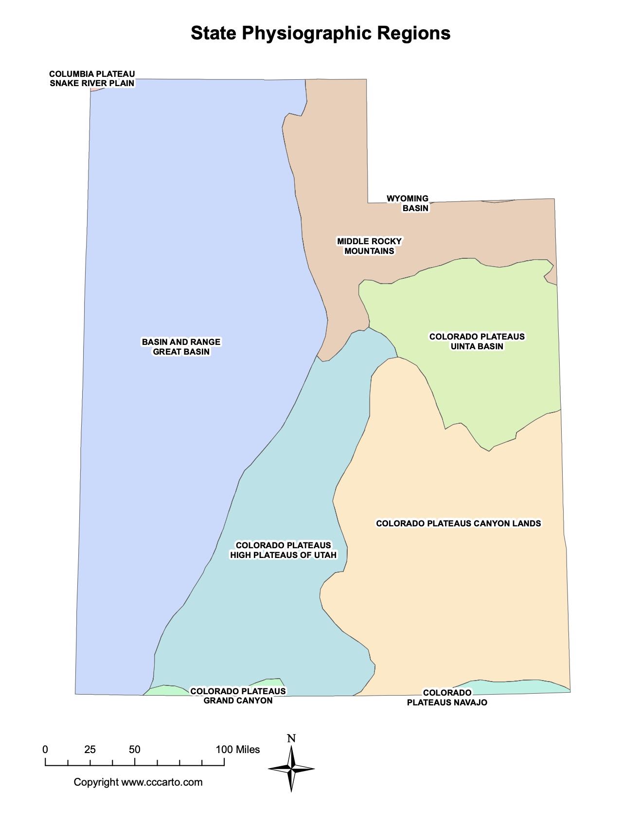
Physiographic Sections of Utah
1. Basin and Range, Great Basin
This section covers western Utah and is characterized by alternating mountain ranges and desert basins. Notable features include the Great Salt Lake, the Bonneville Salt Flats, and a variety of arid, sparsely vegetated valleys. This region represents the northern extension of the larger Great Basin, one of the driest regions in North America.
2. Colorado Plateaus, Canyon Lands
The Canyon Lands section of the Colorado Plateau in southeastern Utah is famous for its deeply eroded landscapes, which include vast mesas, buttes, and canyons. This region includes some of Utah’s most iconic national parks, such as Canyonlands and Arches, known for their stunning red rock formations and desert vistas.
3. Colorado Plateaus, Grand Canyon
Although primarily associated with northern Arizona, the Grand Canyon section of the Colorado Plateau extends into southern Utah. This region features dramatic cliffs, colorful sedimentary rock layers, and deep canyons that are closely related to the geological processes that shaped the Grand Canyon.
4. Colorado Plateaus, High Plateaus of Utah
The High Plateaus of Utah include some of the highest elevations on the Colorado Plateau, such as the Aquarius Plateau, Markagunt Plateau, and Paunsaugunt Plateau. These elevated areas are known for their dramatic cliffs, forested mountains, and expansive plateaus, providing diverse ecosystems and recreational opportunities.
5. Colorado Plateaus, Navajo Section
The Navajo Section extends across southeastern Utah and into Arizona, marked by its characteristic Navajo sandstone formations, including sweeping dunes of red rock. Monument Valley, with its iconic sandstone buttes, is a part of this physiographic region and is one of the most recognized landscapes in the American Southwest.
6. Colorado Plateaus, Uinta Basin
The Uinta Basin in northeastern Utah is a large depression in the Colorado Plateau, bordered by the Uinta Mountains. It is known for its natural gas and oil reserves, as well as its significant paleontological sites, including Dinosaur National Monument. The basin is semi-arid and covered in sagebrush steppe.
7. Columbia Plateau, Snake River Plain
The Snake River Plain, part of the larger Columbia Plateau, extends into northern Utah. It is a volcanic region shaped by ancient lava flows and more recent geologic activity. This region is largely flat and arid, with scattered agricultural areas made fertile through irrigation from the Snake River and its tributaries.
8. Middle Rocky Mountains
The Middle Rocky Mountains section includes the Wasatch and Uinta Ranges, which are part of the larger Rocky Mountains chain. These mountains dominate the landscape of northern and northeastern Utah, providing high peaks, alpine meadows, and glacial valleys. The Wasatch Range is particularly well-known for its ski resorts and outdoor recreation opportunities.
9. Wyoming Basin
The Wyoming Basin covers parts of northeastern Utah and is characterized by its wide, open plains and rolling hills. The region has a semi-arid climate and is primarily used for grazing and energy production. The Green River runs through this basin, creating important riparian habitats in an otherwise dry landscape.
About CCCarto – Utah State Maps Creator
CCCarto has been producing professional digital and GIS maps for large companies, government agencies, and educational institutions since 1988. With over 35 years of cartographic experience, our Utah state maps are designed to the highest standards of accuracy, clarity, and usability.
Our map collection spans counties, cities, federal lands, ecoregions, physiographic regions, topographic relief, and more — giving students, researchers, educators, planners, and curious explorers the best Utah state map resources available online. Every map is optimized for both screen viewing and letter-size printing.
Explore our full U.S. State Maps collection, or browse our Geology Maps, Travel Maps, and Energy Maps.