

Kansas State Maps | Complete Map Collection
Kansas State Maps: Detailed Maps for Counties, Cities, Federal Areas, Physiographic & Ecoregions
Welcome to our comprehensive collection of Kansas State Maps, meticulously curated to provide detailed, high-resolution visualizations of the state’s geography, political boundaries, and natural regions. These maps are designed for students, researchers, planners, and anyone seeking an in-depth visual reference.
- Counties and Cities: Clearly defined county boundaries and major cities for planning, education, and demographic reference.
- Federal Areas: National parks, forests, monuments, wildlife refuges, military installations, and other federally managed lands.
- Physiographic Regions: Major landforms and terrain features such as mountains, plains, valleys, plateaus, and coastal areas.
- Ecoregions: Ecological zones representing forests, grasslands, deserts, wetlands, and other biodiversity regions.
Map Profile
- Format: JPEG
- Color: RGB
- Resolution: ~72 DPI
- Typical image size: ~1300 × 1700 px
- Paper size: Letter (8.5 × 11 inches)
- Layouts: Portrait and Landscape
- File size: ~100–500 KB
Print tip: In your print dialog select Letter (8.5×11), choose Portrait or Landscape, and use Fit to Page (or Scale - to fit).

Kansas Counties
Kansas has 105 counties, largely rectilinear; Johnson & Sedgwick dominate population.
- Number of counties: 105 — List
- First & last established: Territorial 1850s; late 1880s finalizations — Newberry Atlas
- Highest & lowest county: Highest at Mt. Sunflower (Wallace); lowest Verdigris R. (Montgomery) — USGS
- Most & least populated: Most: Johnson; Least: Greeley
- Least & most developed (proxy): Most: Johnson; Least: Greeley
- Most geographically diverse: Geary County (Flint Hills & Milford Lake)
- Strangest-shaped county: Doniphan County (Missouri River scallops)
- State’s Biggest Commodity: Cattle & calves (by cash receipts). USDA ERS
- Largest Private Employer: Walmart. State list
- Top 3 Non-English Languages: Spanish, Vietnamese, German — DataUSA
About CCCarto – Kansas State Maps Creator
CCCarto has been producing professional digital and GIS maps for large companies, government agencies, and educational institutions since 1988. With over 35 years of cartographic experience, our Kansas state maps are designed to the highest standards of accuracy, clarity, and usability.
Our map collection spans counties, cities, federal lands, ecoregions, physiographic regions, topographic relief, and more — giving students, researchers, educators, planners, and curious explorers the best Kansas state map resources available online. Every map is optimized for both screen viewing and letter-size printing.
Explore our full U.S. State Maps collection, or browse our Geology Maps, Travel Maps, and Energy Maps.
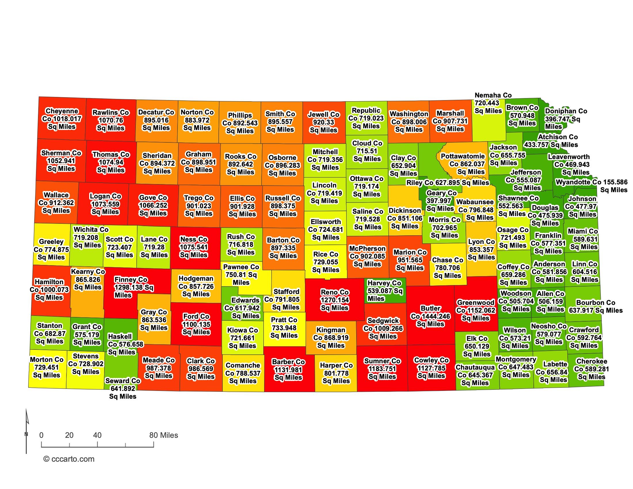
Kansas County Sizes State Map
Smallest County in Kansas State
Wyandotte County: 155 sq miles
Largest County in Kansas State
Butler County: 1,444 sq miles
Mean and Median Area of Counties in Kansas State
Mean Area: Approximately 900 sq miles
Median Area: Approximately 900 sq miles
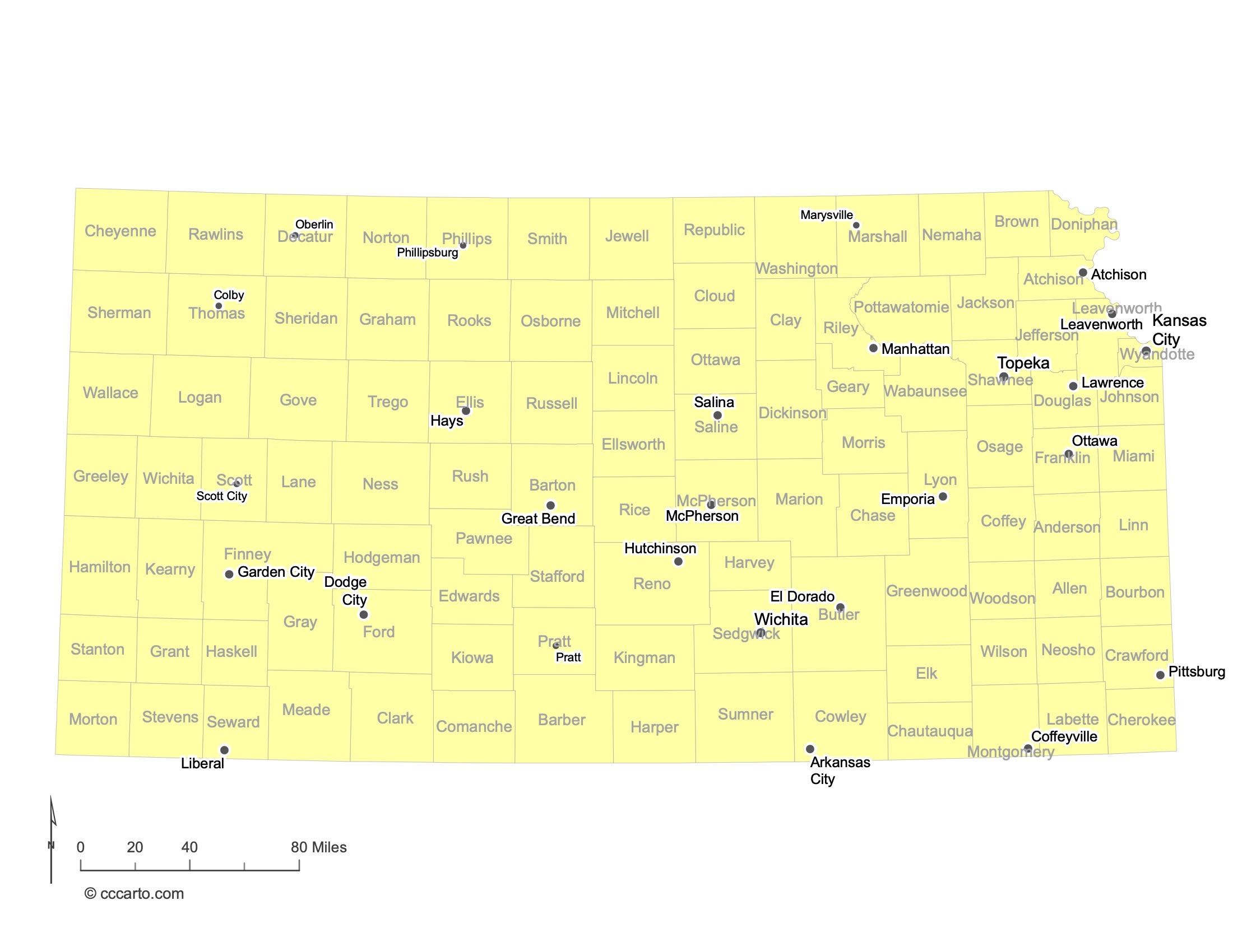
Major Cities of Kansas | Kansas Cities State Map
In Kansas State, major cities are often located along historic transportation routes, near rivers, or in regions significant for trade and agriculture. Below are examples:
1. Cities Along Historic Paths or Routes
Wichita: The largest city in Kansas, Wichita developed as a trading post along the Chisholm Trail. Its central location made it a significant hub for cattle drives in the 19th century and later for aviation, earning it the nickname "Air Capital of the World."
Topeka: The state capital, Topeka is located along the Kansas River and was a key stop on the Oregon Trail. Its location made it an important site for westward expansion and trade.
2. Cities Near Rivers
Kansas City: Situated at the confluence of the Kansas and Missouri Rivers, Kansas City is a major metropolitan area that benefits from river transportation and commerce. The city's location has historically made it a gateway for trade and migration.
Lawrence: Located along the Kansas River, Lawrence was founded by anti-slavery settlers and played a significant role in the state's early history. Its river access facilitated trade and transportation.
3. Agricultural Centers
Dodge City: Known for its rich history as a frontier town, Dodge City is located in southwestern Kansas. It became a major cattle-shipping point on the Great Western Cattle Trail, supporting the agricultural economy.
Salina: Positioned near the Smoky Hill River, Salina serves as a regional trade center for north-central Kansas. Its location has made it a hub for agriculture and manufacturing.
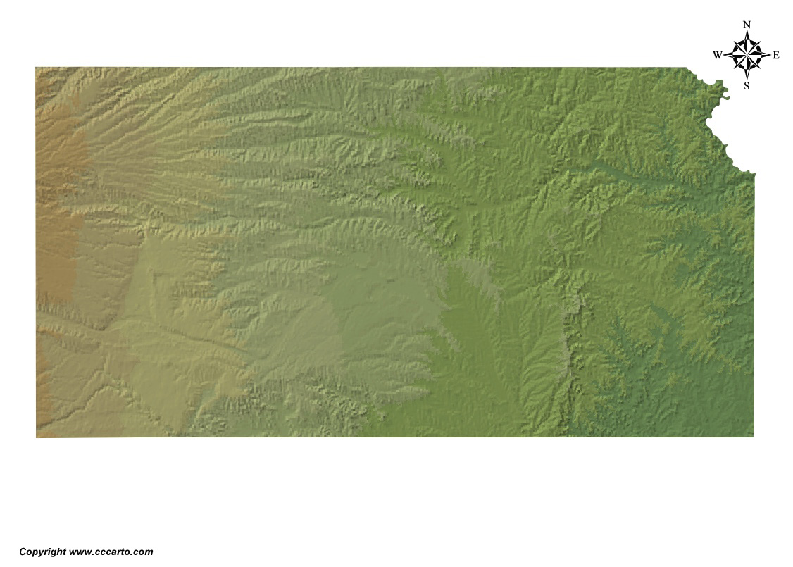
Kansas Topographic State Map | Shaded Relief
Often perceived as flat, Kansas State actually features a variety of terrains that gently rise from east to west. The state's topography includes rolling hills, river valleys, and high plains, reflecting its geological history and influencing its climate and agriculture.
1. Eastern Lowlands
The eastern part of Kansas is characterized by rolling hills, forests, and river valleys. This area includes the Osage Plains and is more humid, supporting hardwood forests and fertile soils ideal for agriculture. The Flint Hills, a region of tallgrass prairie, offer unique landscapes with limestone and flint rock formations.
2. Central Plains
Moving westward, the Central Plains consist of gently rolling terrain and open prairies. This area is part of the larger Great Plains and features fertile soils that are extensively used for farming, particularly wheat and corn. The Smoky Hills region, with its sandstone bluffs and buttes, adds to the varied landscape.
3. Western High Plains
The western third of Kansas rises to higher elevations and is characterized by the High Plains. This region is flatter and drier, with shortgrass prairies dominating the landscape. The climate is more arid, and the area relies heavily on irrigation for agriculture. Notable features include the Chalk Pyramids (Monument Rocks), impressive chalk formations that stand out in the plains.
4. River Systems
Kansas has several significant rivers that traverse the state from west to east, including the Arkansas, Kansas, and Missouri Rivers. These rivers have carved valleys and provide essential water resources for agriculture, wildlife, and human consumption. The river valleys often feature more lush vegetation compared to the surrounding prairies.
5. Flint Hills
The Flint Hills region in east-central Kansas is one of the last remaining tallgrass prairie ecosystems in North America. The area is named for the flint (chert) found in the limestone layers. The rolling hills and rich biodiversity make it a unique landscape, supporting ranching and conservation efforts.
6. Red Hills
Located in south-central Kansas, the Red Hills (also known as the Gyp Hills) are characterized by their reddish soil and gypsum rock formations. The area features canyons, mesas, and buttes, providing a stark contrast to the surrounding plains. The unique geology supports specialized plant and animal life.
7. Glaciated Region
The northeastern corner of Kansas was influenced by glacial activity during the Ice Ages. The glaciated region features hills, ridges, and deposits left by retreating glaciers, contributing to the area's fertile soils and diverse terrain.
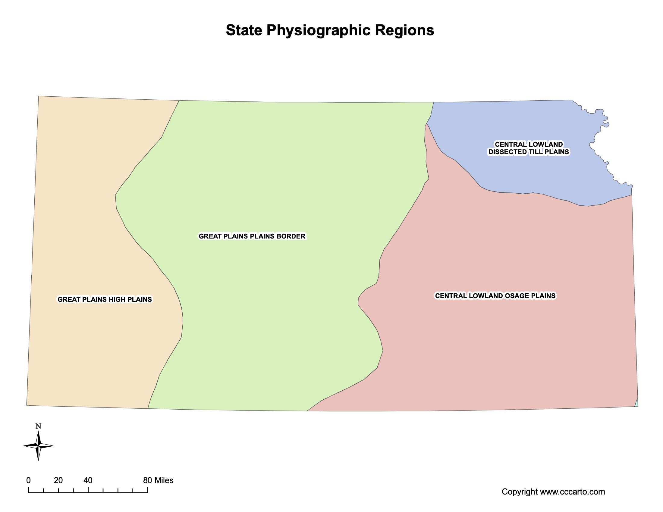
Kansas Physiographic Regions State Map
Central Lowland - Dissected Till Plains
The Dissected Till Plains in northeastern Kansas are characterized by gently rolling hills and fertile soils resulting from glacial deposits. This region was shaped by glaciers during the Pleistocene epoch, leaving behind rich till and loess soils that support extensive agriculture, particularly corn and soybeans.
Central Lowland - Osage Plains
The Osage Plains cover southeastern Kansas and consist of open prairie lands with gentle slopes. The region features sedimentary rocks such as limestone and shale, and the soils are well-suited for grasslands and pasture. The Osage Plains transition into the Ozark Plateau to the east and are important for cattle ranching.
Great Plains - High Plains
The High Plains occupy western Kansas and are characterized by flat to gently rolling terrain at higher elevations. This area is part of the larger High Plains that extend into neighboring states. The region has a semi-arid climate and relies on irrigation from the Ogallala Aquifer for agriculture, primarily wheat and sorghum production.
Great Plains - Plains Border
The Plains Border region is located between the Central Lowland and the High Plains, featuring a mix of rolling hills and flat plains. This transitional zone includes the Smoky Hills and the Red Hills, with rock formations composed of chalk, limestone, and sandstone. The area supports a mix of agriculture and grazing.
Ozark Plateaus - Springfield-Salem Plateaus
The southeastern edge of Kansas touches the Ozark Plateaus, specifically the Springfield-Salem Plateaus. This region is characterized by forested hills, karst topography with caves and sinkholes, and diverse ecosystems. The geology consists mainly of Mississippian-age limestone and chert, and the area supports hardwood forests and some mining activities.
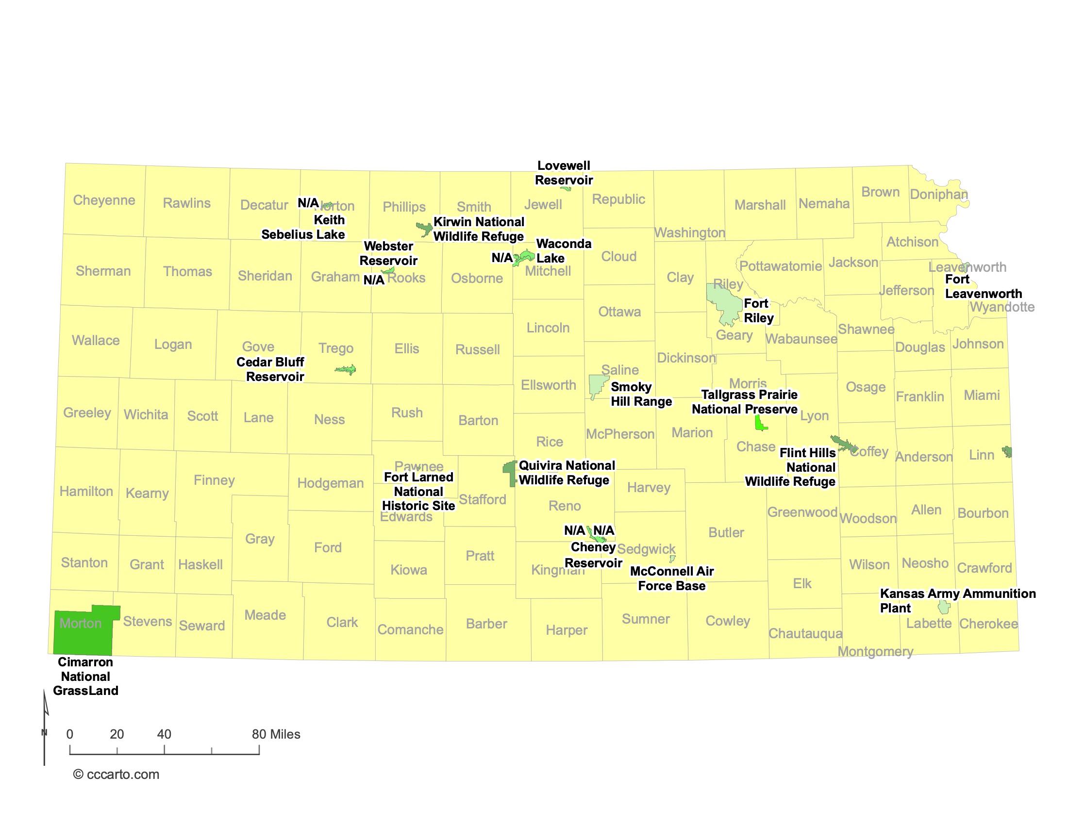
Kansas Federal Lands State Map | National Parks & Protected Areas
1. Tallgrass Prairie National Preserve
The Tallgrass Prairie National Preserve, located in the Flint Hills region, protects a rare remnant of the tallgrass prairie ecosystem that once covered vast areas of North America. Established in 1996, the preserve encompasses nearly 11,000 acres of rolling hills, wildflowers, and diverse wildlife. Visitors can enjoy hiking trails, guided tours, and educational programs that highlight the importance of prairie conservation.
2. Fort Larned National Historic Site
Fort Larned National Historic Site preserves an authentically restored 1860s military fort that played a crucial role in protecting travelers and commerce along the Santa Fe Trail. The site offers a glimpse into frontier life, with original buildings, museum exhibits, and living history demonstrations. It provides valuable insights into military history and Native American relations during the westward expansion.
3. Brown v. Board of Education National Historic Site
Located in Topeka, this historic site commemorates the landmark 1954 Supreme Court decision that declared racial segregation in public schools unconstitutional. The site is housed in the Monroe Elementary School, one of the segregated schools involved in the case. Exhibits and programs educate visitors about the civil rights movement and the ongoing struggle for equality.
4. Nicodemus National Historic Site
Nicodemus National Historic Site preserves the only remaining western town established by African Americans during the Reconstruction Period following the Civil War. Founded in 1877, Nicodemus represents the pioneer spirit of formerly enslaved people seeking freedom and self-determination. Visitors can explore historic buildings and learn about the community's history and cultural heritage.
5. Quivira National Wildlife Refuge
Situated in central Kansas, Quivira National Wildlife Refuge encompasses over 22,000 acres of prairie grasslands, salt marshes, and wetlands. The refuge is a critical stopover for migratory birds along the Central Flyway, attracting birdwatchers and nature enthusiasts. It provides habitat for diverse wildlife, including waterfowl, shorebirds, and whooping cranes.
6. Cimarron National Grassland
Covering more than 108,000 acres in southwestern Kansas, Cimarron National Grassland is the largest area of public land in the state. The grassland offers recreational opportunities such as hiking, camping, fishing, and wildlife viewing. It features a variety of landscapes, including prairie, woodlands, and the Point of Rocks landmark along the historic Santa Fe Trail.
7. Kansas Army Ammunition Plant (now Great Plains Industrial Park)
While not open to the public, the former Kansas Army Ammunition Plant near Parsons has been repurposed into the Great Plains Industrial Park. The site's transformation represents efforts to convert federal lands for community and economic development while addressing environmental concerns from its past military use.
8. Santa Fe National Historic Trail
The Santa Fe National Historic Trail passes through Kansas, marking the historic trade route that connected Missouri to Santa Fe, New Mexico. Various sites along the trail in Kansas offer insights into the state's role in westward expansion, including trail ruts, landmarks, and interpretive centers that highlight the cultural exchanges and challenges of the journey.
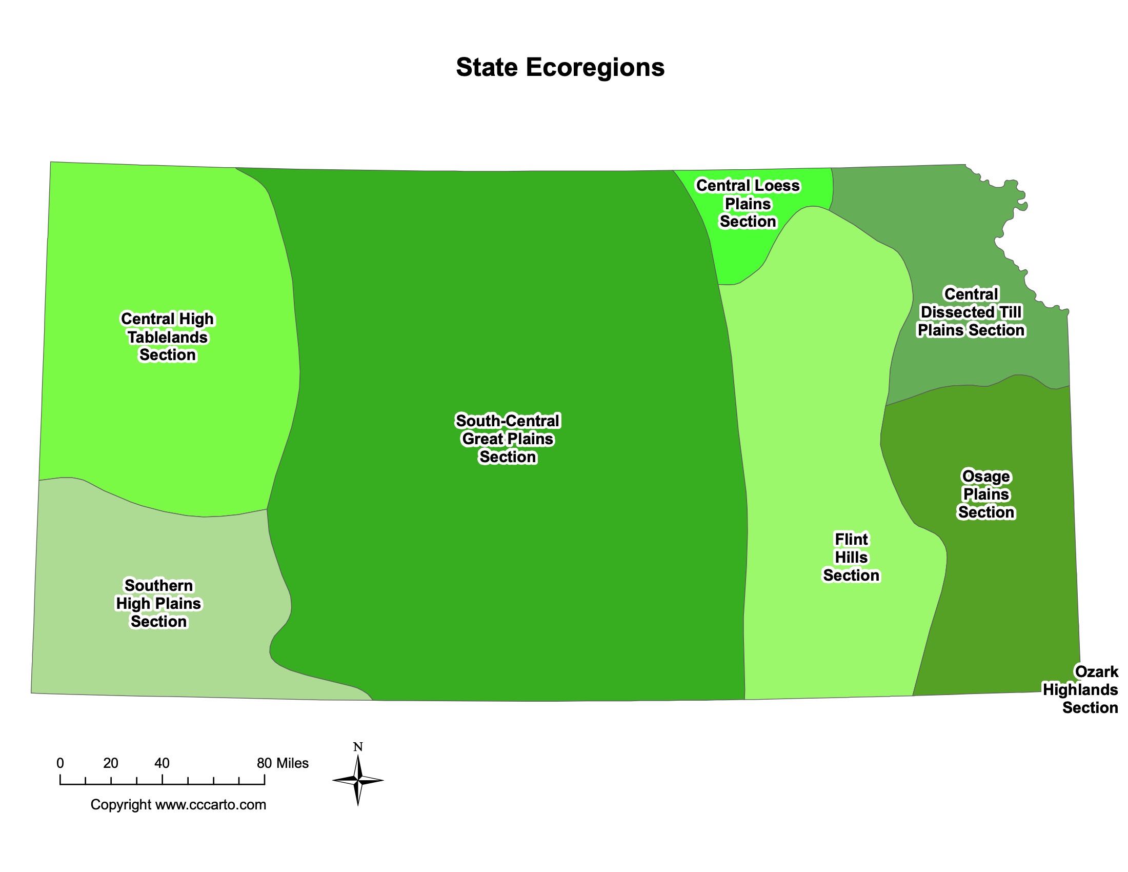
Kansas Ecoregions State Map | EPA Ecological Zones
Central Dissected Till Plains Section
This ecoregion is located in the northeastern corner of Kansas and is characterized by rolling hills and fertile soils derived from glacial till. The area supports a mix of cropland and deciduous forests. The natural vegetation includes oak-hickory forests, but much of the land has been converted to agriculture due to the rich soils.
Central High Tablelands Section
Situated in the northwestern part of the state, the Central High Tablelands are part of the High Plains. This ecoregion features flat to gently rolling terrain with shortgrass prairie vegetation. The semi-arid climate and high elevation make it suitable for grazing and dryland farming, primarily wheat and sorghum.
Central Loess Plains Section
The Central Loess Plains run through central Kansas and are characterized by loess soils deposited by wind. The fertile soils support extensive agriculture, including corn, soybeans, and wheat. The original tallgrass prairie has largely been replaced by cropland, but some remnants remain in protected areas.
Flint Hills Section
The Flint Hills are a unique ecoregion known for their tallgrass prairie and rolling hills composed of flint-rich limestone and shale. This area has shallow soils unsuitable for cultivation, which has helped preserve the native prairie grasses. The region supports cattle ranching and is important for grassland conservation.
Osage Plains Section
Extending into southeastern Kansas, the Osage Plains are characterized by gently rolling prairies and savannas. The ecoregion features a mix of tallgrass and mixed-grass prairies, with soils that support both grazing and some agriculture. The area provides important habitat for grassland birds and other wildlife.
Ozark Highlands Section
The Ozark Highlands occupy a small area in southeastern Kansas. This ecoregion is marked by forested hills, karst topography, and clear streams. The natural vegetation consists of oak-hickory forests, and the area supports diverse plant and animal life. Limestone and chert formations contribute to the region's unique geology.
South-Central Great Plains Section
Located in south-central Kansas, this ecoregion features a mix of prairies and cropland. The terrain is generally flat to gently rolling, with soils derived from ancient sea beds. The area supports agriculture, including wheat and cattle ranching, and contains important wetlands and rivers that provide habitat for wildlife.
Southern High Plains Section
The Southern High Plains in southwestern Kansas are characterized by flat tablelands and a semi-arid climate. This ecoregion features shortgrass prairie vegetation adapted to dry conditions. Agriculture relies heavily on irrigation from the Ogallala Aquifer. The area is important for grain production and supports prairie wildlife.