

Wyoming State Maps Collections
Wyoming State Maps: Detailed Maps for Counties, Cities, Federal Areas, Physiographic & Ecoregions
Welcome to our comprehensive collection of Wyoming State Maps, meticulously curated to provide detailed, high-resolution visualizations of the state’s geography, political boundaries, and natural regions. These maps are designed for students, researchers, planners, and anyone seeking an in-depth visual reference.
- Counties and Cities: Clearly defined county boundaries and major cities for planning, education, and demographic reference.
- Federal Areas: National parks, forests, monuments, wildlife refuges, military installations, and other federally managed lands.
- Physiographic Regions: Major landforms and terrain features such as mountains, plains, valleys, plateaus, and coastal areas.
- Ecoregions: Ecological zones representing forests, grasslands, deserts, wetlands, and other biodiversity regions.
Map Profile
- Format: JPEG
- Color: RGB
- Resolution: ~72 DPI
- Typical image size: ~1300 × 1700 px
- Paper size: Letter (8.5 × 11 inches)
- Layouts: Portrait and Landscape
- File size: ~100–500 KB
Print tip: In your print dialog select Letter (8.5×11), choose Portrait or Landscape, and use Fit to Page (or Scale - to fit).

Wyoming Counties Interesting Facts
Wyoming’s 23 counties (in a state itself bounded by straight lines) are PLSS-aligned with dramatic mountain/divide edges in the west and plains in the east.
- Number of counties: 23. State of Wyoming · List
- First & last established county: First was Laramie (1867); last created were Sublette and Teton (both 1921). Source: Newberry Atlas · WY History
- How borders are set: PLSS grid predominates; major natural edges in the Absarokas/Wind Rivers and river basins. See BLM PLSS.
- Highest & lowest county (elev.): Highest at Gannett Peak on the Fremont/Sublette line; lowest at the Belle Fourche River in Crook County. Source: USGS, Gannett Peak, WY Facts.
- Most & least populated county: Most: Laramie County. Least: Niobrara County.
- Least & most developed (proxy): Most developed: Laramie; least: very low-density Niobrara.
- Most geographically diverse county: Park County (Yellowstone edge, Absaroka peaks, Shoshone River canyons & basins).
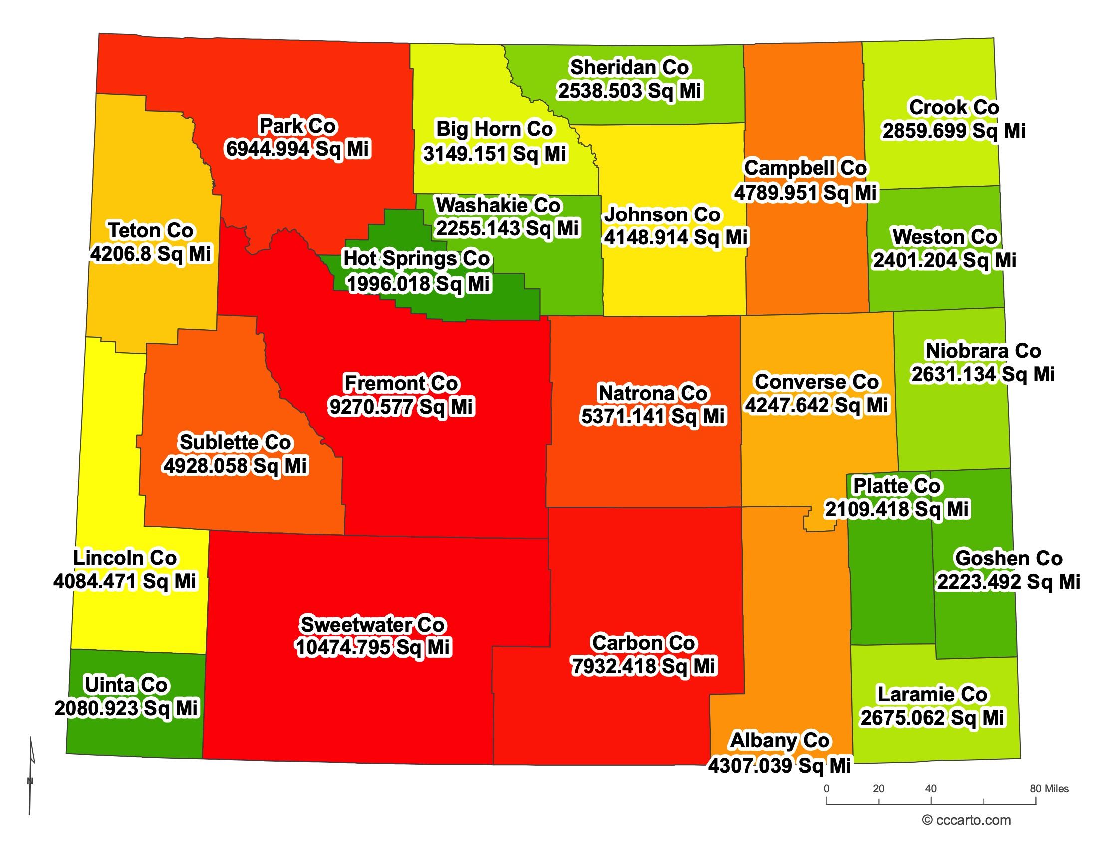
Wyoming County Sizes State Map
Smallest County in Wyoming State
Hot Springs County: 1996 sq miles
Largest County in Wyoming State
Sweetwater County: 10,475 sq miles
Mean and Median Area of Counties in Wyoming State
Mean Area: 6,778 sq miles
Median Area: 4,760 sq miles
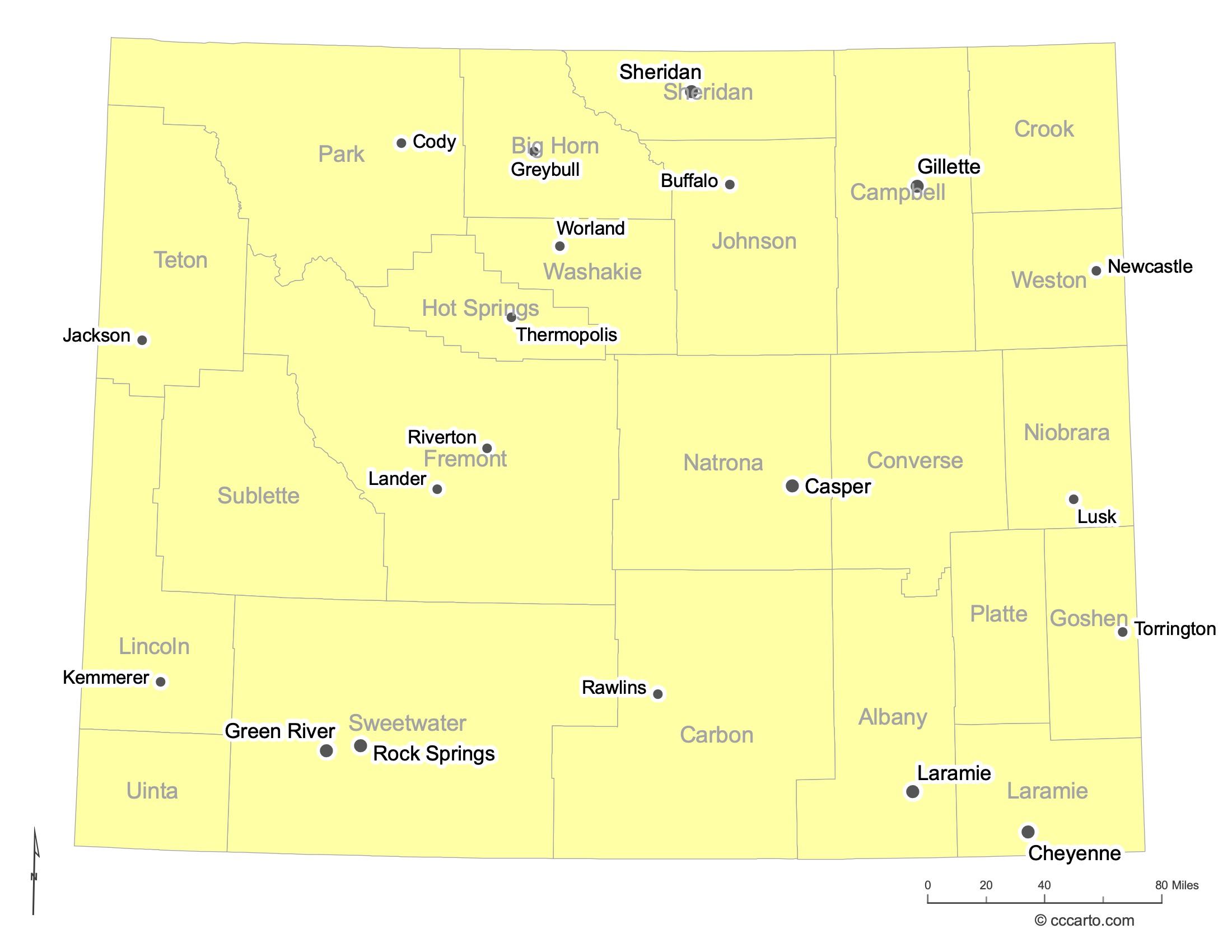
Major Cities of Wyoming | Wyoming Cities State Map
In Wyoming State, major cities are often located in regions with access to resources, transportation routes, or historical significance. Examples include:
1. Resource-Rich Regions
Casper: Known for its historical significance in the oil and energy industry, Casper is a key city in central Wyoming. Its location makes it a central hub for commerce and transportation.
Cheyenne: The capital of Wyoming and a major railroad hub, Cheyenne has long been significant for its role in the expansion of the West.
Rock Springs: Historically important due to coal mining and the railroad, Rock Springs is now known for its natural resources, including oil and gas development.
Gillette: A major center for coal, oil, and natural gas production, Gillette is often called the "Energy Capital of the Nation" due to its vast energy resources.
2. Historic Trails or Routes
Jackson: Jackson's proximity to national parks like Grand Teton and Yellowstone has made it a significant hub for tourism, particularly for those traveling through western Wyoming.
Rawlins: Located along the historic Union Pacific Railroad and on the transcontinental highway, Rawlins played an important role in the development of the western transportation network.
Green River: This city was an essential stop for settlers and explorers, located on the Overland Trail. Today, it's known for its access to outdoor recreation and natural beauty along the Green River.
Laramie: As a center for education and innovation due to the University of Wyoming, Laramie serves as a key city in southern Wyoming along historic travel routes.
3. Strategic Location
Lander: A gateway to the Wind River Range, Lander has long been a strategic location for exploration and outdoor recreation in central Wyoming.
Cody: Named after "Buffalo Bill" Cody, the city serves as a major tourist gateway to Yellowstone National Park and features a strong western heritage.
Lusk: Located near the eastern border of Wyoming, Lusk has historically served as a hub for travelers moving through the region and has ties to the cattle and ranching industries.
Buffalo: Nestled at the foot of the Bighorn Mountains, Buffalo has long been a stop for travelers and is known for its historical sites from the cattle ranching era.
Thermopolis: Famous for its natural hot springs, Thermopolis is a small town with a significant tourist draw due to its location in Hot Springs State Park.
Torrington: Located near the eastern border, Torrington is a key agricultural hub in the state, known for its farming and livestock production.
Newcastle: Newcastle is situated in northeastern Wyoming near the Black Hills and has historically served as a coal mining center.
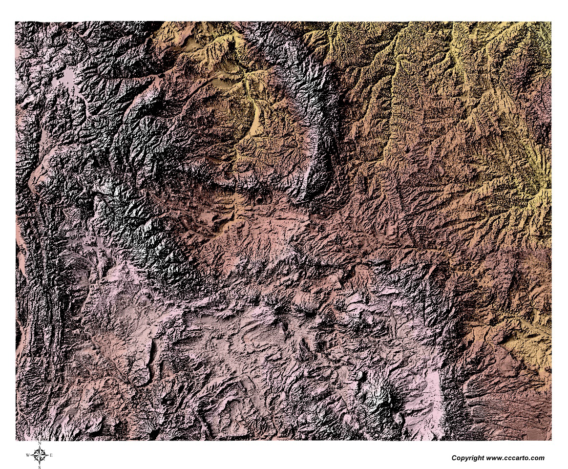
Wyoming Topographic State Map | Shaded Relief
Wyoming State features a range of terrains, from its mountainous regions in the Rockies to the wide-open plains. Below are some key topographic regions:
1. Great Plains
The eastern portion of Wyoming is part of the Great Plains, characterized by rolling hills and wide-open spaces. These plains are known for their agricultural use and serve as a transition between the Rocky Mountains and the Midwest.
2. Rocky Mountains
The Rocky Mountains stretch across Wyoming, offering some of the most dramatic landscapes in the state. Notable mountain ranges include the Wind River Range, Absaroka Range, and the Laramie Range.
3. Wyoming Basin
Between the mountain ranges, Wyoming’s basins are areas of low relief that feature extensive flatlands and plateaus, such as the Green River and Bighorn Basins. These regions are critical for both natural resources and agriculture.
4. High Plains
The southeastern portion of Wyoming, part of the High Plains, is characterized by gently rolling terrain and higher elevations compared to the Great Plains. This area includes grasslands and agricultural regions and is often used for ranching and farming.
5. Salt River Range
The Salt River Range is a small mountain range in the western part of Wyoming, known for its rugged peaks and deep valleys. This area is popular for outdoor activities like hiking, fishing, and camping, with stunning vistas of the surrounding landscape.
6. Tetons
The Teton Range, located in northwestern Wyoming, is one of the most iconic landscapes in the state. Known for its sharp, dramatic peaks, the Tetons rise steeply from the valley floor. This area is famous for Grand Teton National Park and its spectacular alpine scenery, offering numerous opportunities for recreation and wildlife viewing.
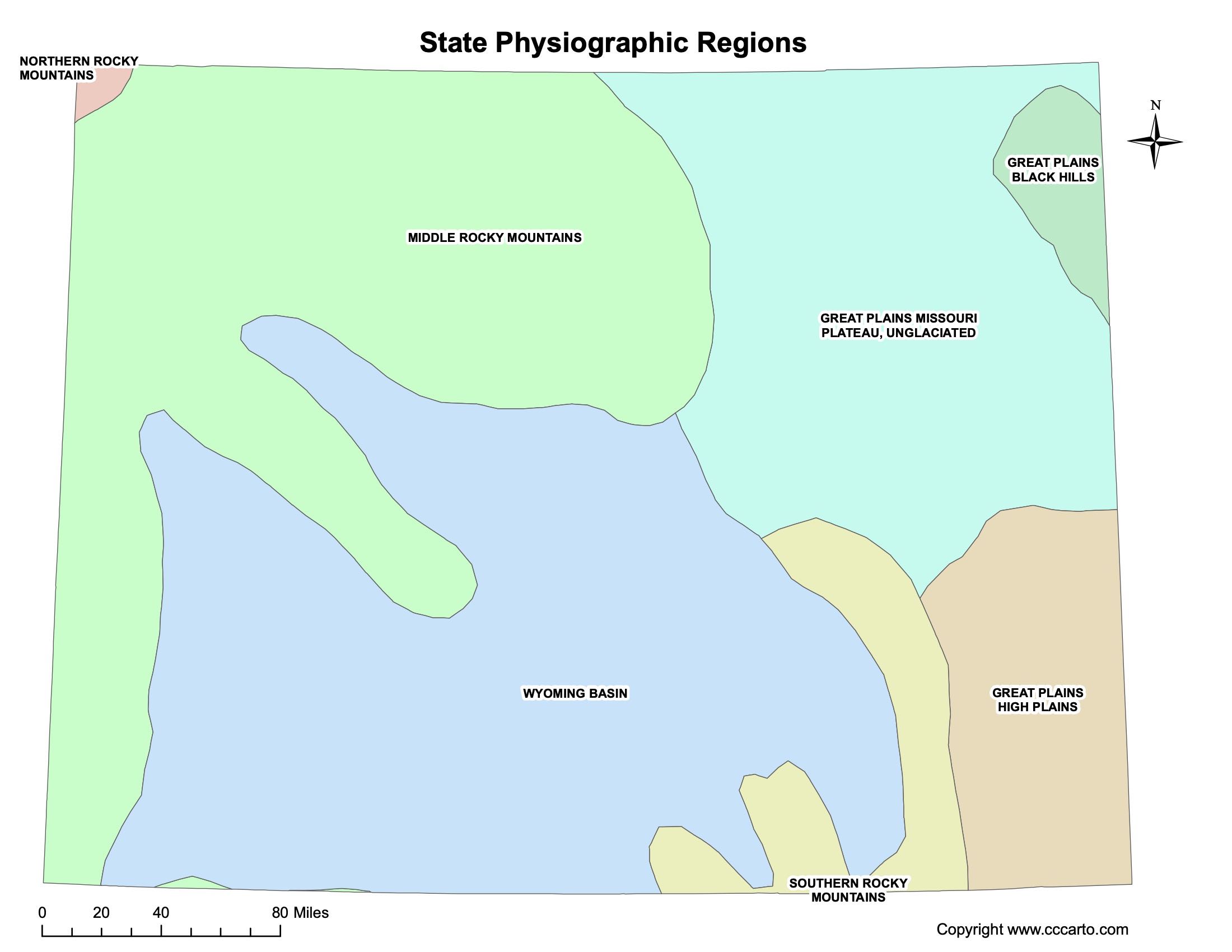
Wyoming Physiographic Regions State Map
Great Plains, Black Hills
The Black Hills section of the Great Plains is found in the northeastern part of Wyoming, with steep hills and valleys that are distinct from the flat plains that surround them.
Great Plains, High Plains
The High Plains of Wyoming stretch across the southeastern region, characterized by open grasslands and occasional river valleys.
Great Plains, Missouri Plateau, Unglaciated
Part of the Great Plains, the Missouri Plateau in Wyoming remains largely unglaciated, featuring rolling terrain with few dramatic changes in elevation.
Middle Rocky Mountains
This region includes the Wind River Range and the Absaroka Range, home to some of Wyoming’s highest peaks, glaciers, and rugged terrain.
Northern Rocky Mountains
Located in the northwestern part of the state, the Northern Rocky Mountains region includes portions of Yellowstone National Park and the Teton Range. This area is characterized by sharp peaks, deep valleys, and extensive forested landscapes. Glacial activity has significantly shaped this rugged region, leaving behind dramatic mountain vistas and large lakes.
Southern Rocky Mountains
The Southern Rocky Mountains region covers areas such as the Medicine Bow Range, featuring steep slopes and alpine meadows.
Wyoming Basin
This lowland area between the mountain ranges features a wide variety of landforms, from plateaus to rolling hills.
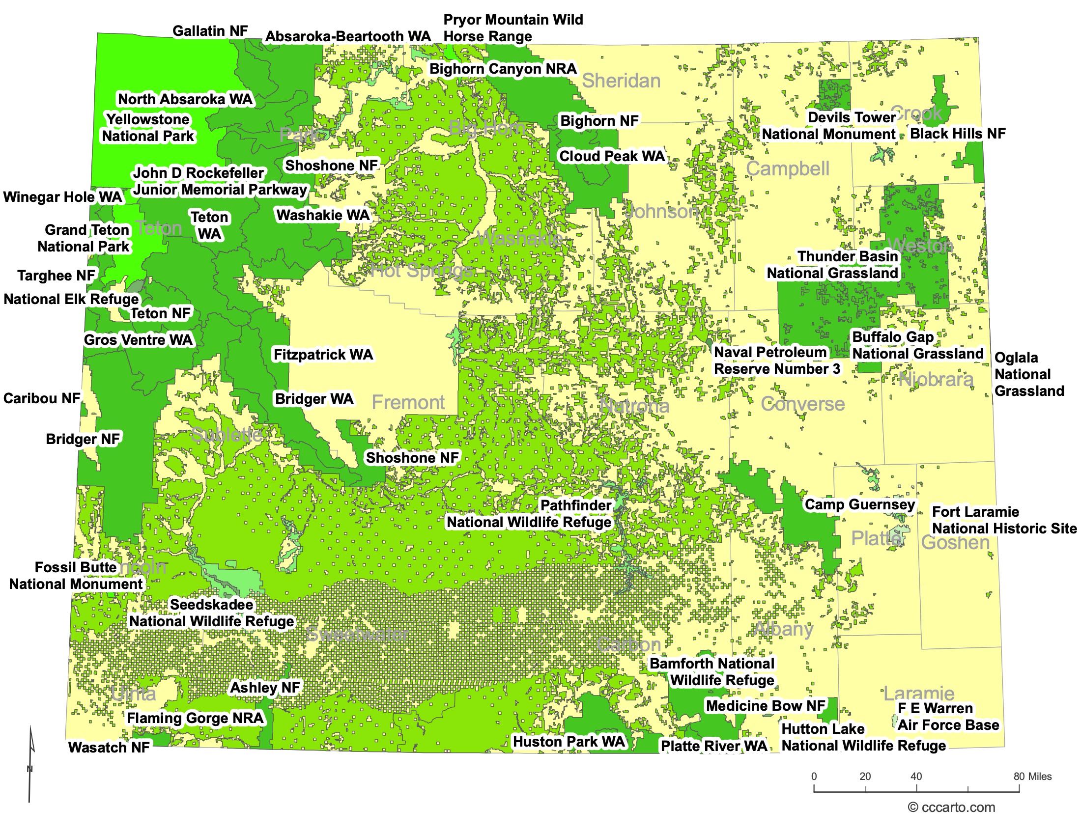
Wyoming Federal Lands State Map | National Parks & Protected Areas
1. Yellowstone National Park
As one of the world’s first national parks, Yellowstone is a renowned destination, famous for its geothermal features, wildlife, and stunning scenery. The park spans both Wyoming and neighboring states but is mostly located in northwestern Wyoming.
2. Grand Teton National Park
Located just south of Yellowstone, Grand Teton National Park is known for its dramatic mountain scenery, with the Teton Range rising sharply above the surrounding landscape.
3. Bighorn National Forest
Bighorn National Forest encompasses portions of the Bighorn Mountains, providing a variety of outdoor activities, including camping, hiking, and fishing. It is home to diverse wildlife and stunning landscapes.
4. Shoshone National Forest
This forest lies along the eastern edge of Yellowstone and contains some of Wyoming’s most remote and wild terrain. It is a popular destination for backpacking and wildlife watching.
5. Medicine Bow National Forest
Covering parts of southeastern Wyoming, Medicine Bow National Forest offers diverse landscapes, including alpine environments and wide expanses of forested areas.
6. John D. Rockefeller, Jr. Memorial Parkway
This parkway connects Yellowstone National Park to Grand Teton National Park and provides a scenic route through one of the most beautiful areas in Wyoming. The area is rich in wildlife, and the parkway offers a variety of recreational opportunities, including hiking and camping.
7. Targhee National Forest
Though mostly located in Idaho, the Targhee National Forest extends into Wyoming and offers stunning views of the Tetons, along with recreational activities such as hiking, horseback riding, and fishing. It is known for its dense forests and rich wildlife habitats.
8. Fossil Butte National Monument
Located in southwestern Wyoming, Fossil Butte National Monument is one of the richest fossil deposits in the world. Visitors can explore the remnants of an ancient lake environment where fossils of fish, plants, and other prehistoric species have been remarkably well-preserved.
9. Flaming Gorge National Recreation Area
Flaming Gorge NRA, located on the Wyoming-Utah border, is known for its dramatic red rock cliffs and the Flaming Gorge Reservoir. The area offers boating, fishing, hiking, and camping, as well as stunning scenic views along its shores.
10. Thunder Basin National Grassland
Located in northeastern Wyoming, Thunder Basin National Grassland features rolling prairies and is home to a variety of wildlife, including prairie dogs, elk, and pronghorn. The area is also important for grazing and offers opportunities for hunting and hiking.
11. Buffalo Gap National Grassland
This grassland spans the border between South Dakota and Wyoming. Known for its scenic beauty and wide-open spaces, Buffalo Gap offers habitat for native species and is used for both conservation and recreation.
12. Oglala National Grassland
Located in Nebraska and stretching into Wyoming, Oglala National Grassland is characterized by its rugged terrain, open prairies, and fossil-rich badlands. The area offers opportunities for hiking, wildlife viewing, and photography.
13. Fort Laramie National Historic Site
This site preserves one of the most important military outposts of the American West. Fort Laramie was a vital stopping point for pioneers traveling the Oregon, Mormon, and California Trails. Today, the site offers historical tours and exhibits about its role in western expansion and relations with Native American tribes.
14. National Wildlife Refuges (NWRs) in Wyoming
- Seedskadee National Wildlife Refuge: Located along the Green River, this refuge protects riparian habitats and provides opportunities to view waterfowl, moose, and other wildlife.
- National Elk Refuge: Situated near Jackson, this refuge is famous for its large wintering elk population. It offers sleigh rides during the winter months to view the herds up close.
- Hutton Lake National Wildlife Refuge: A smaller refuge near Laramie, Hutton Lake is an important habitat for migratory birds, offering birdwatching opportunities in a serene setting.
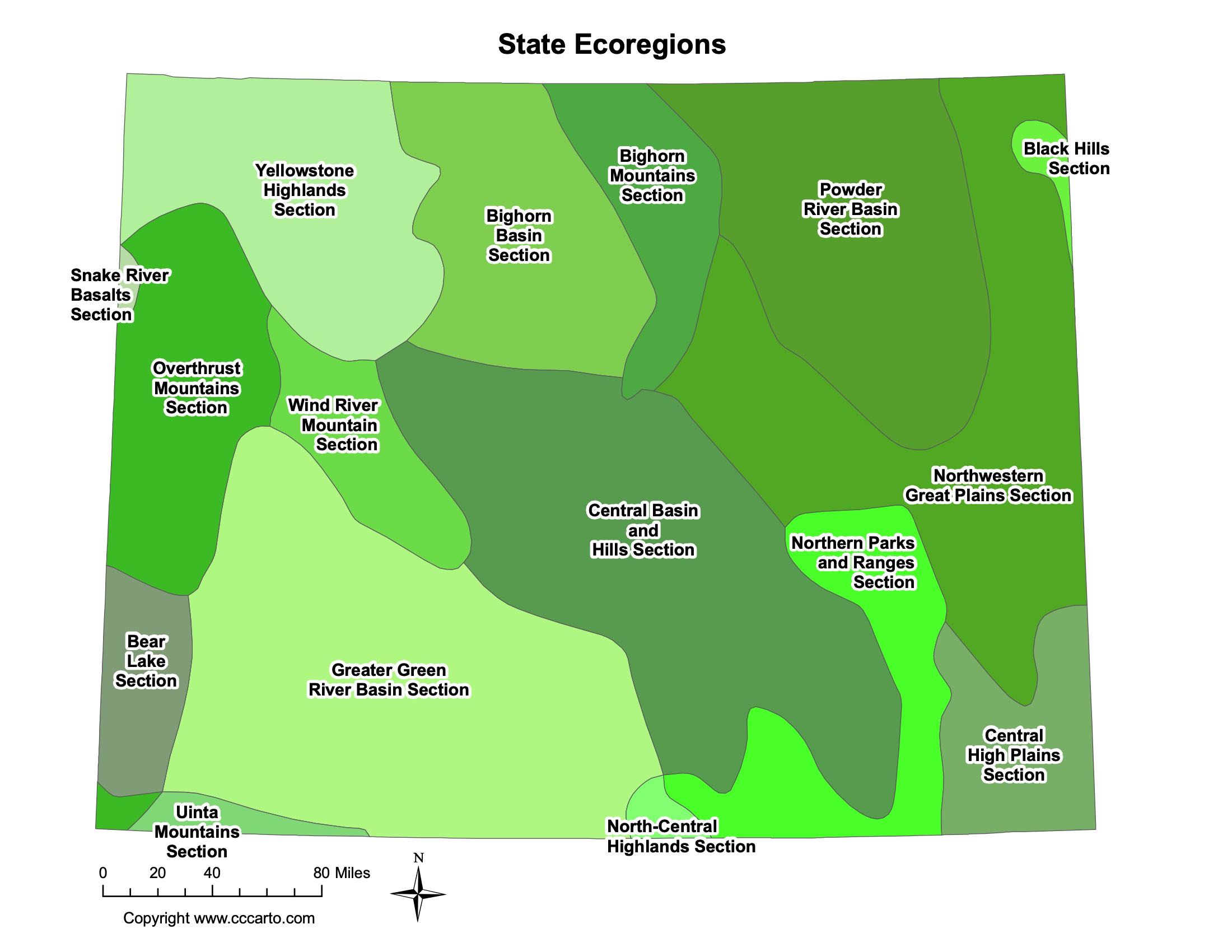
Wyoming Ecoregions State Map | EPA Ecological Zones
Bear Lake Section
This ecoregion in the southwestern corner of Wyoming includes wetlands and lakes, with a rich variety of wildlife habitats.
Bighorn Basin Section
The Bighorn Basin is a dry, semi-arid region that features unique rock formations and provides important grazing lands for livestock.
Bighorn Mountains Section
This ecoregion contains the rugged Bighorn Mountains, an area known for its steep canyons, alpine environments, and diverse wildlife.
Black Hills Section
Located in northeastern Wyoming, the Black Hills feature rugged terrain with forested hills and deep valleys, offering habitats for species like elk and mountain lions.
Central Basin and Hills Section
This semi-arid ecoregion includes rolling hills and flat basins, providing important grazing areas and habitats for species like pronghorn and mule deer.
Central High Plains Section
The Central High Plains section covers southeastern Wyoming and features open grasslands, river valleys, and a mix of agriculture and natural prairies.
Greater Green River Basin Section
This ecoregion covers southwestern Wyoming and includes the Green River and its surrounding dry basins. It is known for its rich fossil deposits and supports species like sage grouse and pronghorn.
North-Central Highlands Section
This region includes a mix of forested highlands and valleys in north-central Wyoming, featuring important habitats for elk, moose, and other large mammals.
Northern Parks and Ranges Section
This ecoregion, located in northwestern Wyoming, includes areas of high elevation, forests, and open meadows, providing vital habitats for wildlife such as grizzly bears and bighorn sheep.
Northwestern Great Plains Section
Stretching across parts of northeastern Wyoming, this ecoregion is characterized by rolling plains, grasslands, and scattered buttes. It supports large populations of pronghorn and other grassland species.
Overthrust Mountains Section
This section includes the western part of Wyoming, where the Overthrust Belt features dramatic ridges and valleys formed by tectonic activity. It offers important habitats for wildlife and opportunities for outdoor recreation.
Powder River Basin Section
Located in northeastern Wyoming, this basin is known for its energy resources, including coal and natural gas. The landscape is a mix of grasslands and low, rolling hills.
Snake River Basalts Section
The Snake River Basalts ecoregion, located in the northwestern part of the state, features volcanic rock formations and fertile valleys, providing important agricultural areas and habitats for wildlife.
Uinta Mountains Section
The Uinta Mountains in southwestern Wyoming are characterized by high peaks, alpine environments, and dense forests, offering excellent opportunities for outdoor recreation and wildlife conservation.
Wind River Mountain Section
The Wind River Mountains include some of Wyoming's tallest peaks, glaciers, and alpine ecosystems, offering prime destinations for mountaineering and hiking.
Yellowstone Highlands Section
This ecoregion includes the highlands of Yellowstone National Park, with its unique geothermal features, forests, and wildlife.
About CCCarto – Wyoming State Maps Creator
CCCarto has been producing professional digital and GIS maps for large companies, government agencies, and educational institutions since 1988. With over 35 years of cartographic experience, our Wyoming state maps are designed to the highest standards of accuracy, clarity, and usability.
Our map collection spans counties, cities, federal lands, ecoregions, physiographic regions, topographic relief, and more — giving students, researchers, educators, planners, and curious explorers the best Wyoming state map resources available online. Every map is optimized for both screen viewing and letter-size printing.
Explore our full U.S. State Maps collection, or browse our Geology Maps, Travel Maps, and Energy Maps.