

Wisconsin State Maps | Complete Map Collection
Wisconsin State Maps: Detailed Maps for Counties, Cities, Federal Areas, Physiographic & Ecoregions
Welcome to our comprehensive collection of Wisconsin State Maps, meticulously curated to provide detailed, high-resolution visualizations of the state’s geography, political boundaries, and natural regions. These maps are designed for students, researchers, planners, and anyone seeking an in-depth visual reference.
- Counties and Cities: Clearly defined county boundaries and major cities for planning, education, and demographic reference.
- Federal Areas: National parks, forests, monuments, wildlife refuges, military installations, and other federally managed lands.
- Physiographic Regions: Major landforms and terrain features such as mountains, plains, valleys, plateaus, and coastal areas.
- Ecoregions: Ecological zones representing forests, grasslands, deserts, wetlands, and other biodiversity regions.
Map Profile
- Format: JPEG
- Color: RGB
- Resolution: ~72 DPI
- Typical image size: ~1300 × 1700 px
- Paper size: Letter (8.5 × 11 inches)
- Layouts: Portrait and Landscape
- File size: ~100–500 KB
Print tip: In your print dialog select Letter (8.5×11), choose Portrait or Landscape, and use Fit to Page (or Scale - to fit).
Wisconsin Counties Interesting Facts
About CCCarto – Wisconsin State Maps Creator
CCCarto has been producing professional digital and GIS maps for large companies, government agencies, and educational institutions since 1988. With over 35 years of cartographic experience, our Wisconsin state maps are designed to the highest standards of accuracy, clarity, and usability.
Our map collection spans counties, cities, federal lands, ecoregions, physiographic regions, topographic relief, and more — giving students, researchers, educators, planners, and curious explorers the best Wisconsin state map resources available online. Every map is optimized for both screen viewing and letter-size printing.
Explore our full U.S. State Maps collection, or browse our Geology Maps, Travel Maps, and Energy Maps.
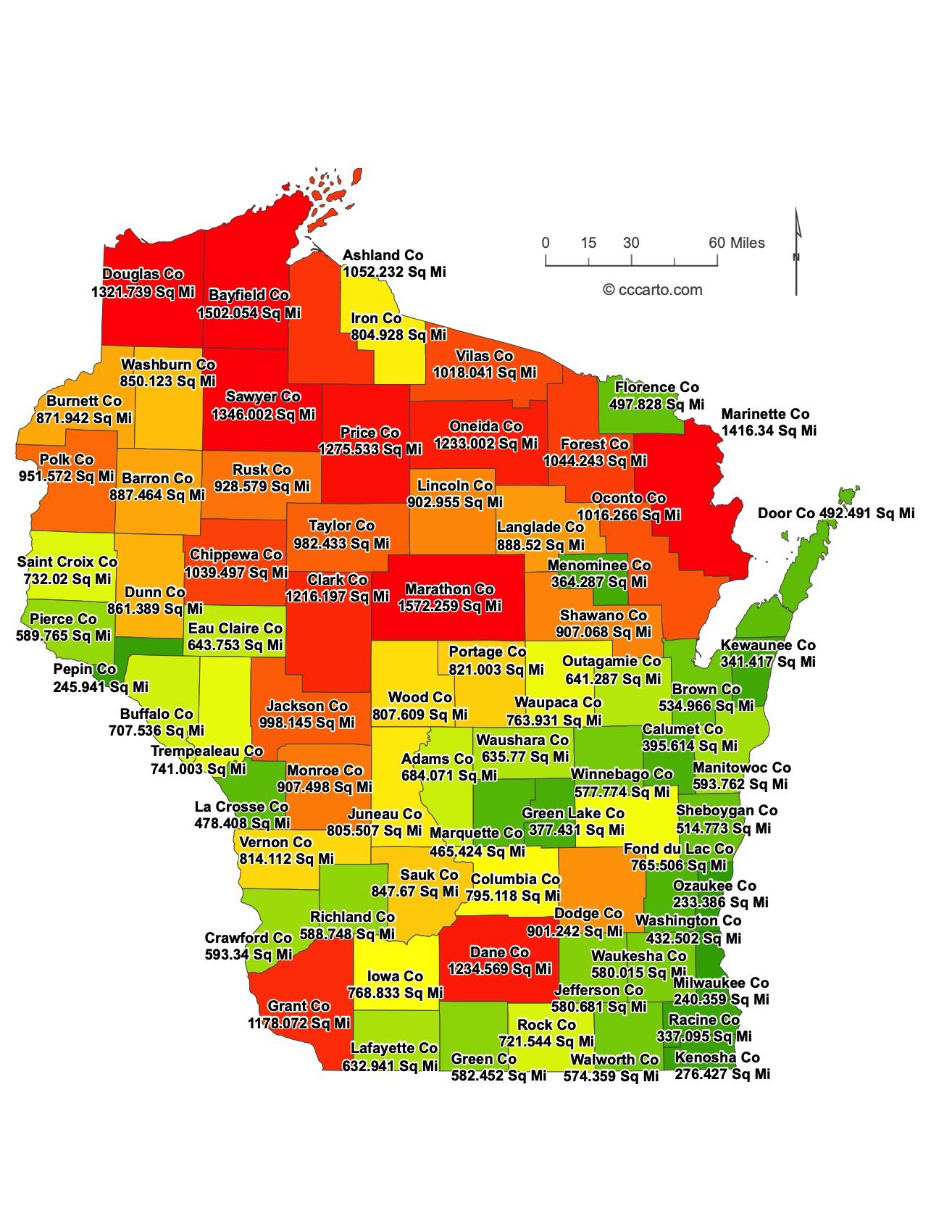
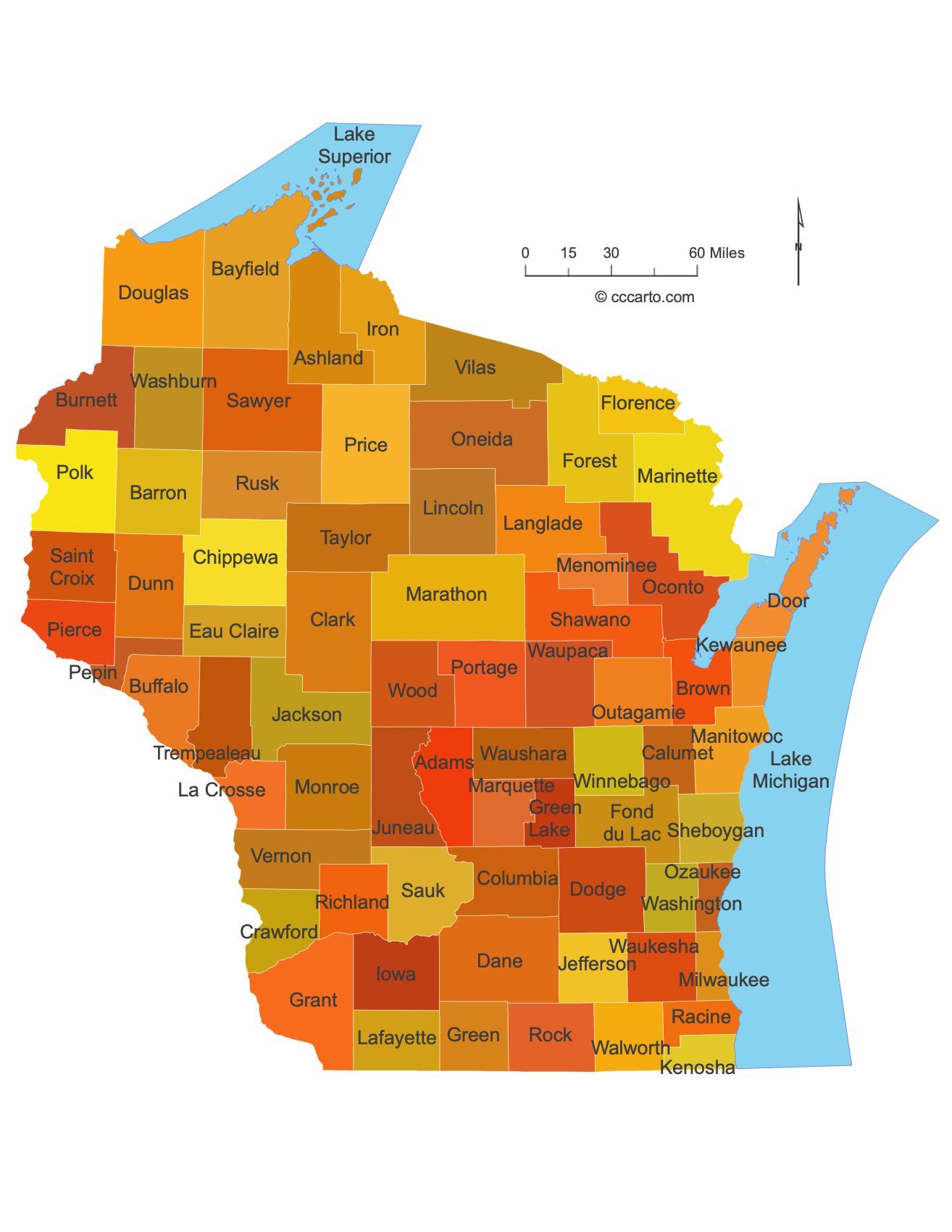
Wisconsin County Sizes State Map
Smallest County in Wisconsin State
Ozaukee County: 233 sq miles
Largest County in Wisconsin State
Marathon County: 1,572 sq miles
Mean and Median Area of Counties in Wisconsin State
Mean Area: 745.79 sq miles
Median Area: 727 sq miles
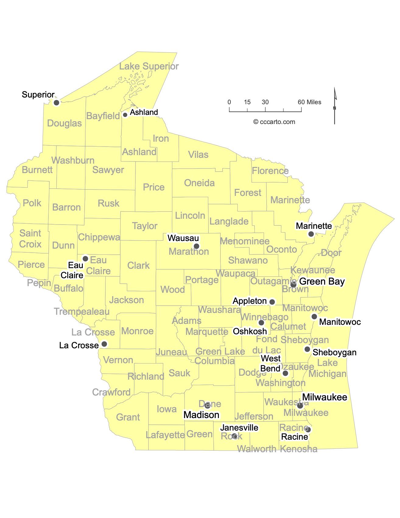
Major Cities of Wisconsin | Wisconsin Cities State Map
In Wisconsin State, most major cities are strategically located near lakes, rivers, or along major transportation routes. Below are examples of each type:
1. Lakeside Cities
Milwaukee: Wisconsin's largest city, located on Lake Michigan, is a hub for commerce and culture. Its location along the lake has made it an important industrial and trading center.
Green Bay: A city located on the western shore of Lake Michigan's Green Bay. Its port has been significant for shipping and trade.
2. River Cities
La Crosse: Located along the Mississippi River, La Crosse serves as a critical hub for transportation and industry in western Wisconsin.
Wausau: Situated along the Wisconsin River, Wausau has historically been a center for the timber and paper industries.
3. Central and Interior Cities
Madison: Wisconsin's capital, located near lakes Mendota and Monona, is a center for government and education. The city is also known for its historic architecture and cultural institutions.
Eau Claire: Located at the confluence of the Eau Claire and Chippewa Rivers, Eau Claire is a center for industry, education, and healthcare in western Wisconsin.
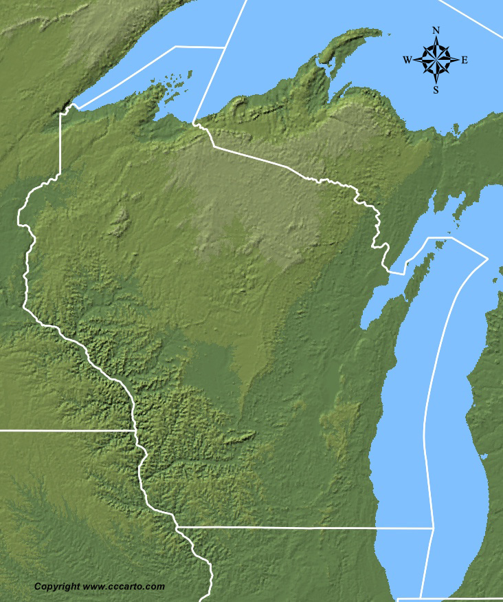
Wisconsin Topographic State Map | Shaded Relief
Wisconsin's terrain is shaped by its unique geology, climate, and natural features. From the rolling hills of the Driftless Area to the lake shorelines and the forested uplands, Wisconsin offers a diverse landscape.
1. Central Lowland, Eastern Lake Section
This area covers the eastern portion of Wisconsin, bordering Lake Michigan. It includes sandy beaches, coastal wetlands, and fertile plains. This region's moderate climate and lake access support agriculture and industry.
2. Central Lowland, Till Plains Section
The Till Plains are known for their gently rolling hills and fertile soils. This area was shaped by glacial activity, leaving behind rich farmland and prairies.
3. Central Lowland, Western Lake Section
Located in the northwestern part of the state, this region contains forested hills, glacial lakes, and rivers. It is an important area for outdoor recreation, including fishing, camping, and boating.
4. Central Lowland, Wisconsin Driftless Section
The Driftless Area of southwestern Wisconsin was not covered by glaciers, resulting in unique landforms such as steep hills, ridges, and deep valleys. This region is renowned for its picturesque landscapes and outdoor recreational activities like hiking and canoeing.
5. Superior Upland
This region encompasses the northern part of Wisconsin and is characterized by its rugged terrain, dense forests, and mineral-rich soils. The area is known for its natural beauty and resources, including iron and copper deposits.
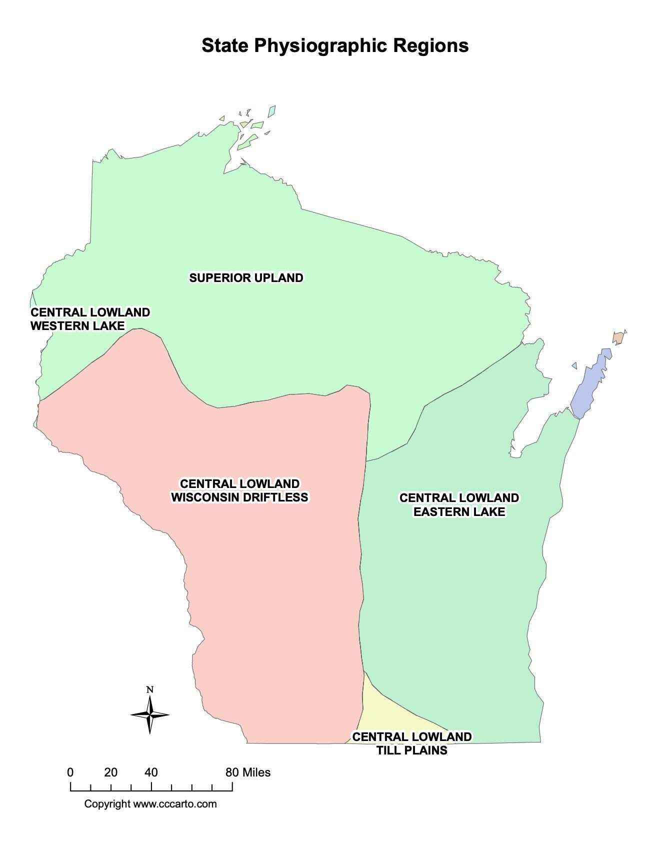
Wisconsin Physiographic Regions State Map
Central Lowland, Eastern Lake Section
This region includes coastal plains and wetlands along Lake Michigan, with gently rolling hills, sandy shores, and extensive agricultural lands.
Central Lowland, Till Plains Section
The Till Plains feature gently undulating hills, fertile soils, and numerous small rivers and lakes. This section was shaped by glaciers, leaving behind some of the state's best farmland.
Central Lowland, Western Lake Section
This section is marked by numerous lakes, rivers, and forested areas, making it a popular destination for outdoor enthusiasts. The region includes the Apostle Islands National Lakeshore on Lake Superior.
Central Lowland, Wisconsin Driftless Section
The Driftless Area is known for its steep hills and valleys, shaped by rivers and erosion rather than glaciers. It is one of the most scenic regions in the Midwest.
Superior Upland
The Superior Upland is a forested region known for its rugged landscapes and mineral deposits. The area includes part of the Chequamegon-Nicolet National Forest and is important for timber production and outdoor recreation.
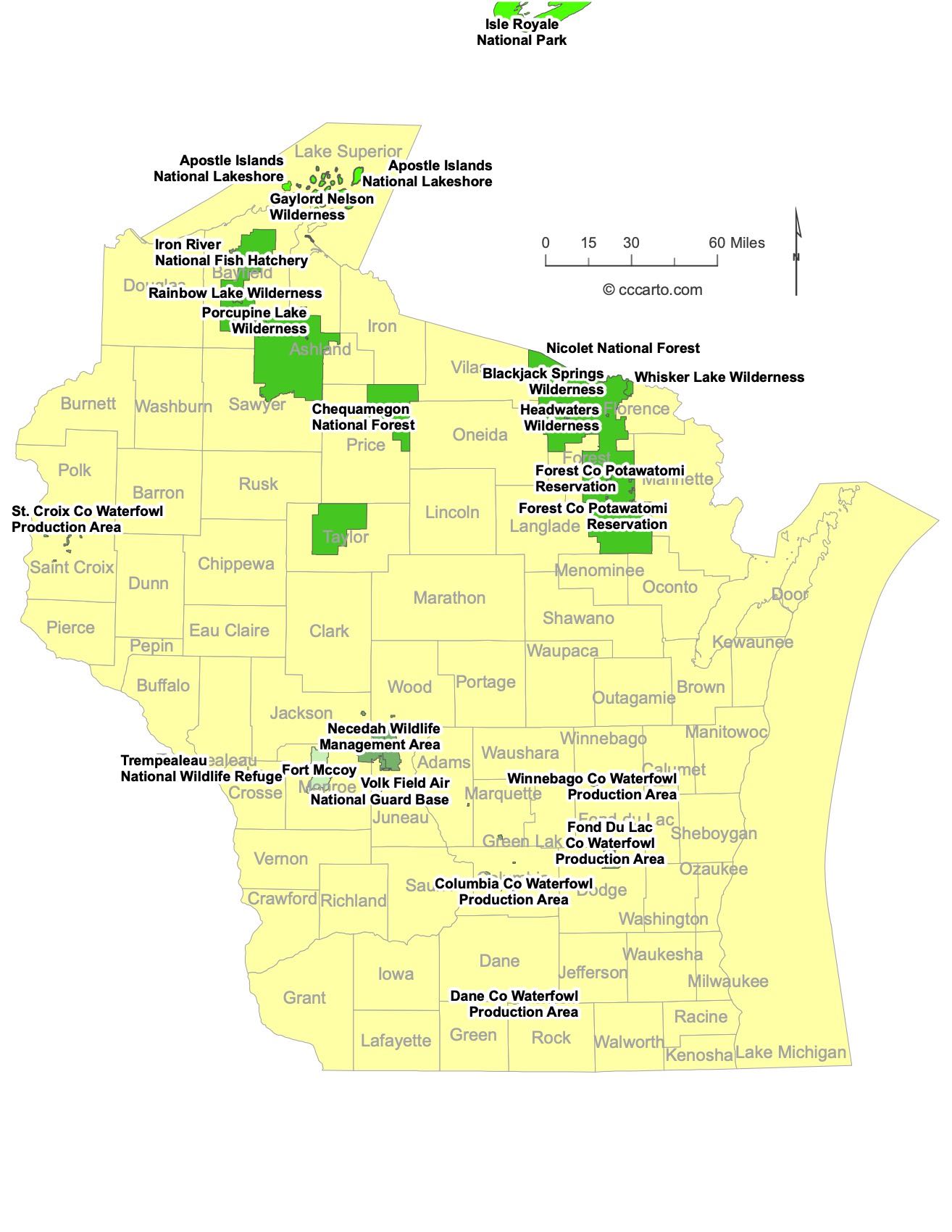
Wisconsin Federal Lands State Map | National Parks & Protected Areas
1. Apostle Islands National Lakeshore
Located on Lake Superior, Apostle Islands National Lakeshore encompasses 21 islands and a beautiful shoreline. It is famous for its sea caves, historic lighthouses, and diverse ecosystems, making it a popular destination for kayaking, hiking, and camping.
2. Chequamegon-Nicolet National Forest
This vast forest covers over 1.5 million acres in northern Wisconsin. Known for its biodiversity, the forest offers countless opportunities for hiking, camping, fishing, and winter sports. The forest also contains historic logging camps and scenic byways.
3. St. Croix National Scenic Riverway
The St. Croix and Namekagon rivers form the heart of this national scenic riverway, offering 252 miles of pristine, protected waterways. Popular activities include paddling, fishing, and camping along the rivers.
4. Gaylord Nelson Wilderness
This wilderness area, named after the former Wisconsin governor and U.S. senator who founded Earth Day, is part of the Apostle Islands National Lakeshore. It protects much of the islands’ natural beauty and ecosystems, offering opportunities for primitive camping and exploring undisturbed landscapes.
5. Headwaters Wilderness
Located within the Chequamegon-Nicolet National Forest, the Headwaters Wilderness covers nearly 22,000 acres of forested land, protecting streams and wetlands that form the headwaters of several rivers. It is a popular destination for hiking, fishing, and wildlife watching.
6. Rainbow Lake Wilderness
This wilderness area within the Chequamegon National Forest covers approximately 6,500 acres of forest, lakes, and streams. It offers excellent opportunities for solitude, hiking, and canoeing, as well as wildlife viewing and fishing.
7. Porcupine Lake Wilderness
Covering over 8,000 acres within the Chequamegon National Forest, Porcupine Lake Wilderness is a scenic area featuring numerous lakes, streams, and old-growth forests. Visitors can enjoy fishing, hiking, and backcountry camping in a remote and serene setting.
8. Whisker Lake Wilderness
Encompassing nearly 7,500 acres, Whisker Lake Wilderness is located in the Nicolet National Forest. It is a pristine area of hardwood and pine forests, offering solitude and opportunities for backcountry hiking, camping, and exploring untouched natural landscapes.
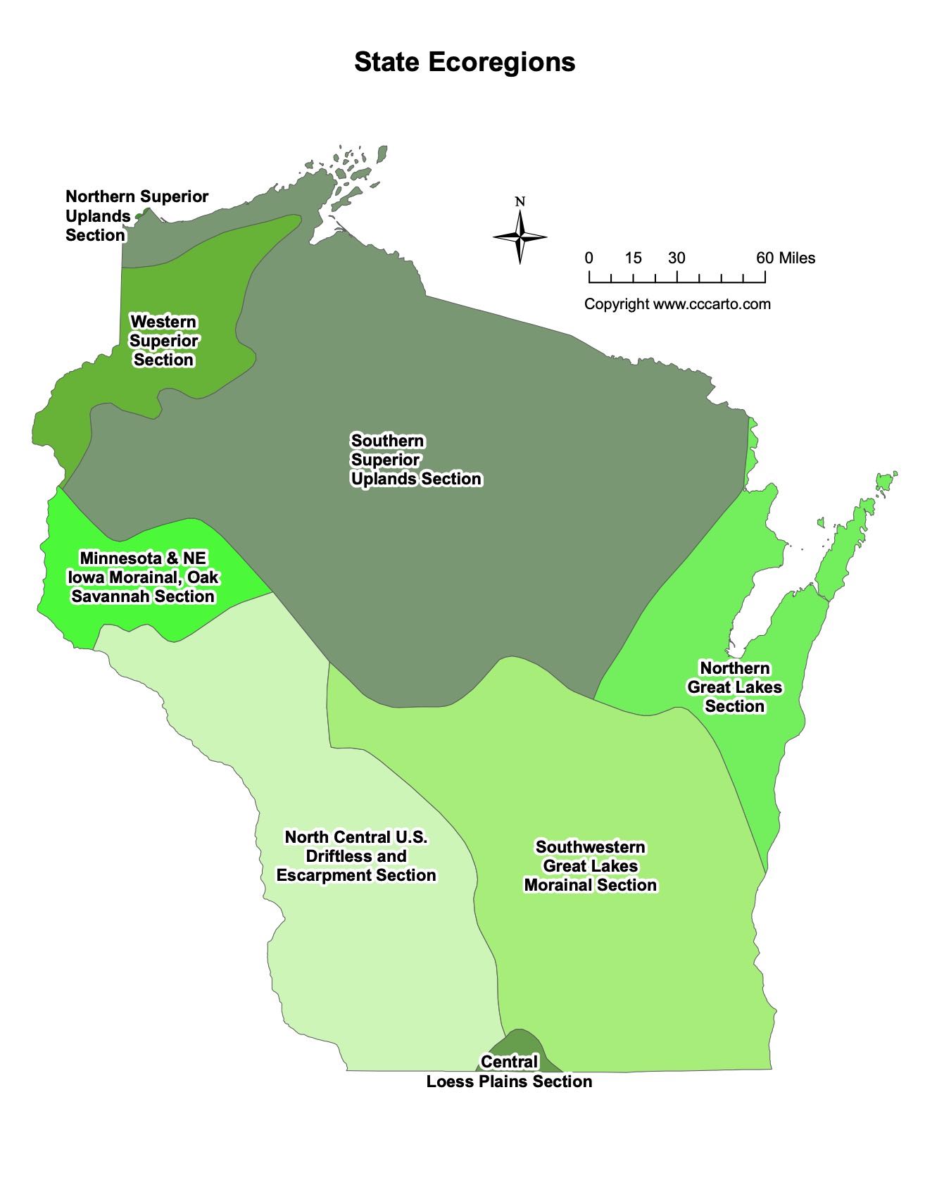
Wisconsin Ecoregions State Map | EPA Ecological Zones
Central Loess Plains Section
The Central Loess Plains Section is marked by fertile soils, loess deposits, and productive farmland. It is an important agricultural region in the state.
Northern Great Lakes Section
This section includes the forests and wetlands of northern Wisconsin. The region is home to a variety of wildlife and supports timber production, outdoor recreation, and conservation efforts.
Northern Superior Uplands Section
This area features rugged terrain, rich forests, and numerous lakes. It is a popular destination for outdoor enthusiasts, offering opportunities for hiking, fishing, and camping.
Southern Superior Uplands Section
Known for its forested hills and mineral deposits, the Southern Superior Uplands Section is a diverse region that supports forestry, mining, and outdoor recreation.
Southwestern Great Lakes Morainal Section
This region includes moraines, drumlins, and rolling hills formed by glacial activity. The landscape is characterized by small lakes, rivers, and fertile farmland.
Western Superior Section
The Western Superior Section encompasses part of the Lake Superior shoreline and is known for its scenic beauty, forests, and outdoor recreational activities. The Apostle Islands National Lakeshore is located in this section.