

Mississippi State Maps | Complete Map Collection
Mississippi State Maps: Detailed Maps for Counties, Cities, Federal Areas, Physiographic & Ecoregions
Welcome to our comprehensive collection of Mississippi State Maps, meticulously curated to provide detailed, high-resolution visualizations of the state’s geography, political boundaries, and natural regions. These maps are designed for students, researchers, planners, and anyone seeking an in-depth visual reference.
- Counties and Cities: Clearly defined county boundaries and major cities for planning, education, and demographic reference.
- Federal Areas: National parks, forests, monuments, wildlife refuges, military installations, and other federally managed lands.
- Physiographic Regions: Major landforms and terrain features such as mountains, plains, valleys, plateaus, and coastal areas.
- Ecoregions: Ecological zones representing forests, grasslands, deserts, wetlands, and other biodiversity regions.
Map Profile
- Format: JPEG
- Color: RGB
- Resolution: ~72 DPI
- Typical image size: ~1300 × 1700 px
- Paper size: Letter (8.5 × 11 inches)
- Layouts: Portrait and Landscape
- File size: ~100–500 KB
Print tip: In your print dialog select Letter (8.5×11), choose Portrait or Landscape, and use Fit to Page (or Scale - to fit).

Mississippi Counties Interesting Facts
Mississippi’s 82 counties stretch from hills to Gulf Coast; Hinds & DeSoto lead counts.
- Number of counties: 82 — List
- First & last established: Territorial (1799+); last Humphreys (1918) — Newberry Atlas
- Highest & lowest county: Highest at Woodall Mtn (Tishomingo); lowest sea level on Gulf (Harrison) — USGS
- Most & least populated: Most: Hinds; Least: Issaquena
- Least & most developed (proxy): Most: Hinds; Least: Issaquena
- Most geographically diverse: Harrison County (beaches, bays, pine flatwoods)
- Strangest-shaped county: Issaquena County (serpentine river strip)
- State’s Biggest Commodity: Broilers. MSU Extension
- Largest Private Employer: Walmart (statewide). State list
- Top 3 Non-English Languages: Spanish, Vietnamese, Chinese — DataUSA
About CCCarto – Mississippi State Maps Creator
CCCarto has been producing professional digital and GIS maps for large companies, government agencies, and educational institutions since 1988. With over 35 years of cartographic experience, our Mississippi state maps are designed to the highest standards of accuracy, clarity, and usability.
Our map collection spans counties, cities, federal lands, ecoregions, physiographic regions, topographic relief, and more — giving students, researchers, educators, planners, and curious explorers the best Mississippi state map resources available online. Every map is optimized for both screen viewing and letter-size printing.
Explore our full U.S. State Maps collection, or browse our Geology Maps, Travel Maps, and Energy Maps.

Mississippi County Sizes State Map
Smallest County in Mississippi State
Alcorn County: 400 sq miles
Largest County in Mississippi State
Yazoo County: 928 sq miles
Mean and Median Area of Counties in Mississippi State
Mean Area: 645 sq miles
Median Area: 598 sq miles

Major Cities of Mississippi | Mississippi Cities State Map
In Mississippi State, major cities often lie along river systems or historic transportation routes. Below are examples:
1. River Cities
Jackson: The capital city is located along the Pearl River and serves as a political and economic hub.
Vicksburg: Historically significant as a port city along the Mississippi River.
Natchez: One of the oldest cities in the state, situated along the Mississippi River, known for its antebellum homes and historical significance.
Gulfport: A major port city on the Gulf Coast, known for its shipping and tourism industries.
Biloxi: Another key coastal city along the Gulf of Mexico, famous for its casinos and seafood industry.
Tupelo: Located near the Tombigbee River, Tupelo is known as the birthplace of Elvis Presley and serves as a regional economic hub.
Corinth: A city near the Tennessee border, known for its Civil War history and its proximity to the Tennessee and Mississippi rivers.
Oxford: A cultural and academic center, home to the University of Mississippi, located near the Tallahatchie River.
2. Transportation Hubs
Hattiesburg: Located along historic rail routes, Hattiesburg is an economic and education center, home to the University of Southern Mississippi.
Meridian: Another city located along key transportation routes, serving as a vital railroad junction and historically important for the timber industry.


Mississippi Topographic State Map | Shaded Relief
Mississippi State features diverse landscapes, from coastal plains to river valleys. Below are highlights:
1. Coastal Plains
The southern part of the state features low-lying coastal plains, with marshes, estuaries, and tidal flats. This area is critical for fishing and trade.
2. Mississippi Alluvial Plain
This fertile region lies along the western part of the state, where the Mississippi River has carved deep valleys and deposited rich soil over time.
3. Interior Hills
Central Mississippi is characterized by rolling hills, forests, and farmland. It includes areas like the Pine Belt and Black Belt, known for their distinct geography and ecosystems.

Mississippi Physiographic Regions State Map
Coastal Plain, East Gulf Coastal Plain
The Coastal Plain extends across southern Mississippi, including beaches, marshlands, and estuaries, supporting tourism, fishing, and agriculture.
Coastal Plain, Mississippi Alluvial Plain
This region is characterized by flat floodplains and rich soils along the Mississippi River. The area is important for agriculture, especially cotton farming.

Mississippi Federal Lands State Map | National Parks & Protected Areas
1. Natchez Trace Parkway
The Natchez Trace Parkway is a scenic road stretching through the state, offering history and nature enthusiasts a chance to explore Mississippi's landscapes, from rolling hills to dense forests, and historical landmarks along the route.
2. Mississippi Sandhill Crane National Wildlife Refuge
Located along the Gulf Coast, this refuge protects the endangered Mississippi Sandhill Crane and its wet pine savannah habitat, providing critical conservation for this rare bird species.
3. De Soto National Forest
De Soto National Forest offers recreation, hiking, and camping opportunities in Mississippi's Pine Belt, featuring longleaf pine ecosystems and abundant wildlife. It's a popular destination for outdoor activities.
4. Black Creek Wilderness
Located within De Soto National Forest, Black Creek Wilderness is a federally designated wilderness area known for its unspoiled beauty, hiking, canoeing, and wildlife viewing along Black Creek, a National Wild and Scenic River.
5. Vicksburg National Military Park
This park preserves the site of the Civil War’s Siege of Vicksburg. Visitors can explore the battlefield, restored fortifications, and monuments, making it an essential destination for history enthusiasts.
6. Holly Springs National Forest
Located in the northern part of the state, Holly Springs National Forest offers scenic beauty, hiking, fishing, and hunting. Its rolling hills and hardwood forests are a favorite for outdoor recreation.
7. Bienville National Forest
This national forest provides opportunities for hiking, camping, fishing, and wildlife viewing. Its lush forests and numerous lakes and streams attract visitors year-round.
8. Gulf Islands National Seashore
Located along the Gulf Coast, Gulf Islands National Seashore offers beautiful beaches, historic forts, and rich marine life, providing visitors with opportunities for swimming, boating, and exploring coastal habitats.
9. Grand Bay National Wildlife Refuge
Situated on the Mississippi-Alabama border, this refuge protects valuable coastal habitats, including marshes and wetlands, and is a crucial area for migratory birds and other wildlife.
10. Tombigbee National Forest
This forest, located in northeastern Mississippi, is known for its mixed hardwood and pine forests, offering recreational opportunities such as hiking, horseback riding, and hunting.
11. Homochitto National Forest
Located in southwestern Mississippi, Homochitto National Forest features extensive pine forests and is popular for camping, hiking, and birdwatching.
12. Panther Swamp National Wildlife Refuge
This refuge, located in the Mississippi Delta, is known for its wetland habitats, supporting waterfowl and a variety of wildlife species. It is a popular destination for birdwatching and hunting.
13. Yazoo National Wildlife Refuge
Located in the Mississippi Delta, Yazoo National Wildlife Refuge is the oldest national wildlife refuge in the state, offering wetland habitats for waterfowl and providing excellent opportunities for wildlife observation and hunting.
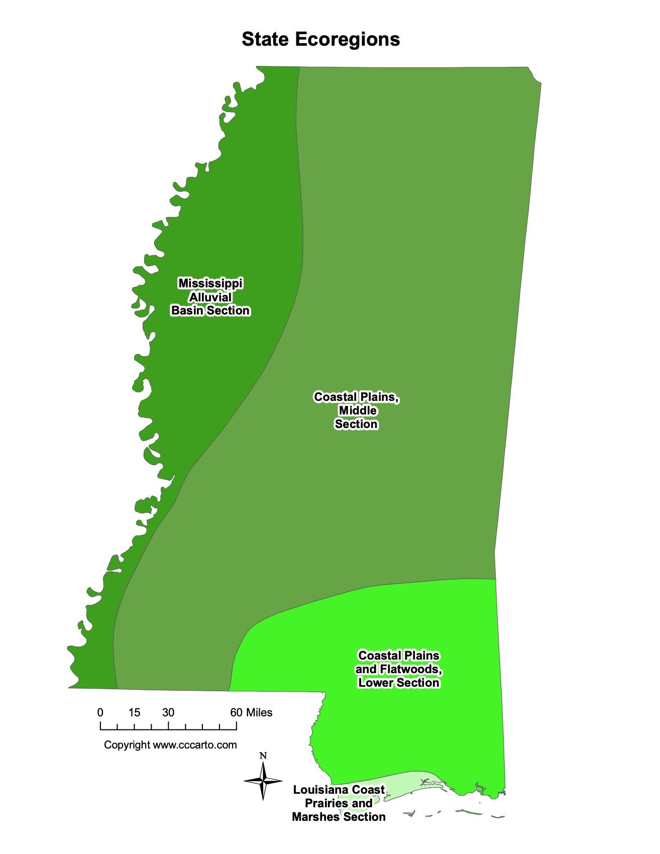
Mississippi Ecoregions State Map | EPA Ecological Zones
Coastal Plains and Flatwoods, Lower Section
This region includes the flatwoods along the Gulf Coast, with wetland forests and wildlife-rich areas, crucial for biodiversity conservation.
Coastal Plains, Middle Section
This inland section of the coastal plains features a mix of forests, wetlands, and agriculture, with important timber and farming industries.
Louisiana Coast Prairies and Marshes Section
This area along the southern border with Louisiana includes marshlands and prairies that support fishing, shrimping, and bird habitats.
Mississippi Alluvial Basin Section
The fertile floodplains along the Mississippi River, known for agriculture, particularly cotton and soybean farming, are part of this region.