

Texas State Maps | Complete Map Collection
Texas State Maps: Detailed Maps for Counties, Cities, Federal Areas, Physiographic & Ecoregions
Welcome to our comprehensive collection of Texas State Maps, meticulously curated to provide detailed, high-resolution visualizations of the state’s geography, political boundaries, and natural regions. These maps are designed for students, researchers, planners, and anyone seeking an in-depth visual reference.
- Counties and Cities: Clearly defined county boundaries and major cities for planning, education, and demographic reference.
- Federal Areas: National parks, forests, monuments, wildlife refuges, military installations, and other federally managed lands.
- Physiographic Regions: Major landforms and terrain features such as mountains, plains, valleys, plateaus, and coastal areas.
- Ecoregions: Ecological zones representing forests, grasslands, deserts, wetlands, and other biodiversity regions.
Map Profile
- Format: JPEG
- Color: RGB
- Resolution: ~72 DPI
- Typical image size: ~1300 × 1700 px
- Paper size: Letter (8.5 × 11 inches)
- Layouts: Portrait and Landscape
- File size: ~100–500 KB
Print tip: In your print dialog select Letter (8.5×11), choose Portrait or Landscape, and use Fit to Page (or Scale - to fit).
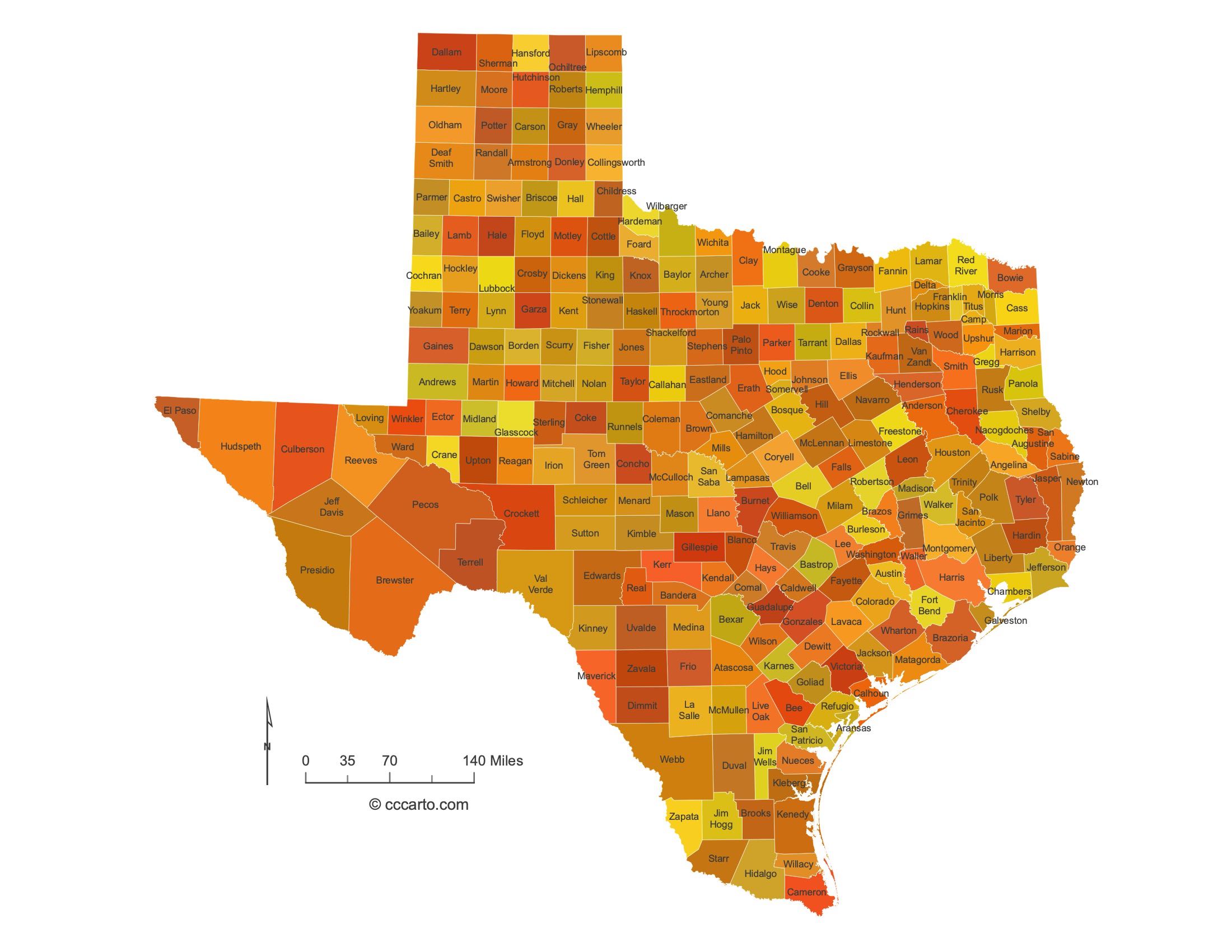
Texas Counties
Texas has 254 counties—more than any other state. Boundaries reflect Spanish/Mexican-era metes-and-bounds surveys and later rectilinear layouts in the Panhandle; Texas is not a PLSS state. See Texas Association of Counties and the Texas GLO’s overview of land survey systems.
- Number of counties: 254 (TAC)
- First & last established: Last county created: Kenedy (1921); last to organize its government: Loving (1931)
- Highest & lowest county (elevation): Highest point at Guadalupe Peak in Culberson County; lowest is sea level along Gulf Coast counties (USGS)
- Most & least populated county: Most: Harris County; Least: Loving County
- Least & most developed (proxy = population density): Most dense: Dallas County; Least dense: Loving County
- Most geographically diverse county (reasoned pick): Culberson County (includes the state’s highest ranges in Guadalupe Mountains NP and Chihuahuan Desert lowlands)
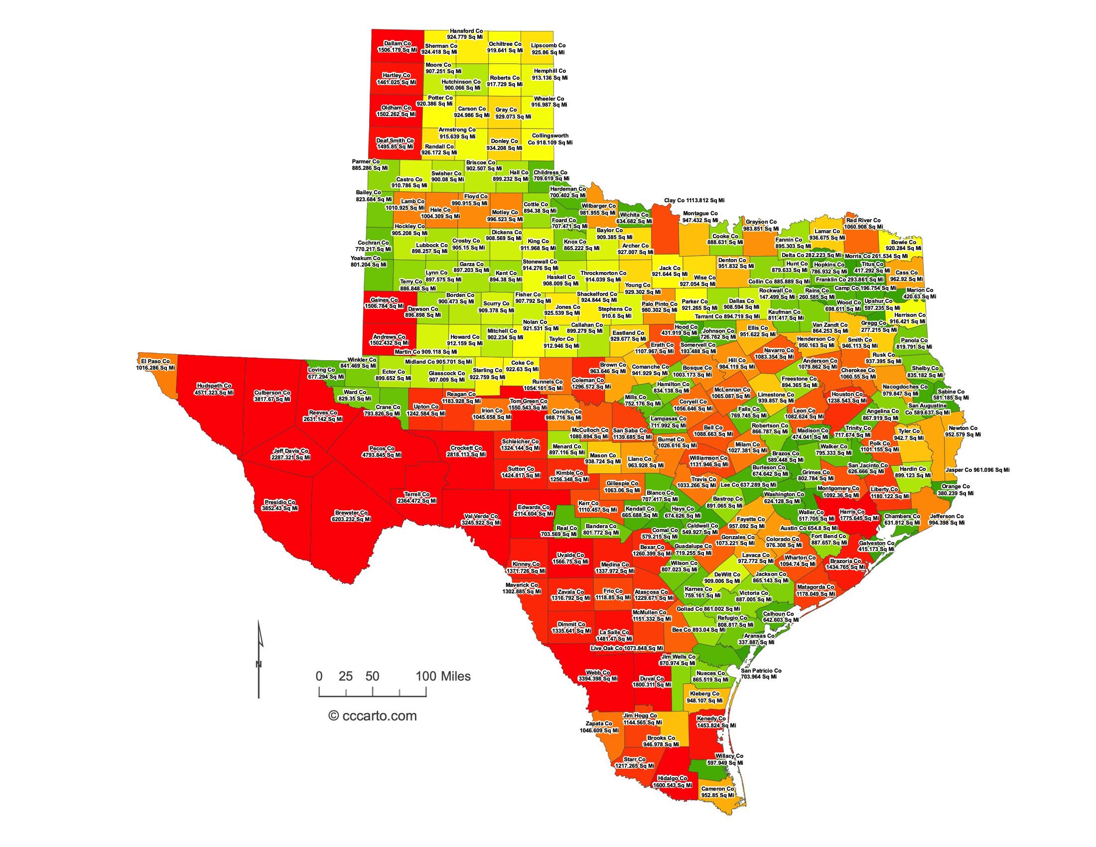
Texas County Sizes State Map
Smallest County in Texas State
Rockwall County: 147 sq miles
Largest County in Texas State
Brewster County: 6,203 sq miles
Mean and Median Area of Counties in Texas State
Mean Area: 1006.4 sq miles
Median Area: 905.2 sq miles
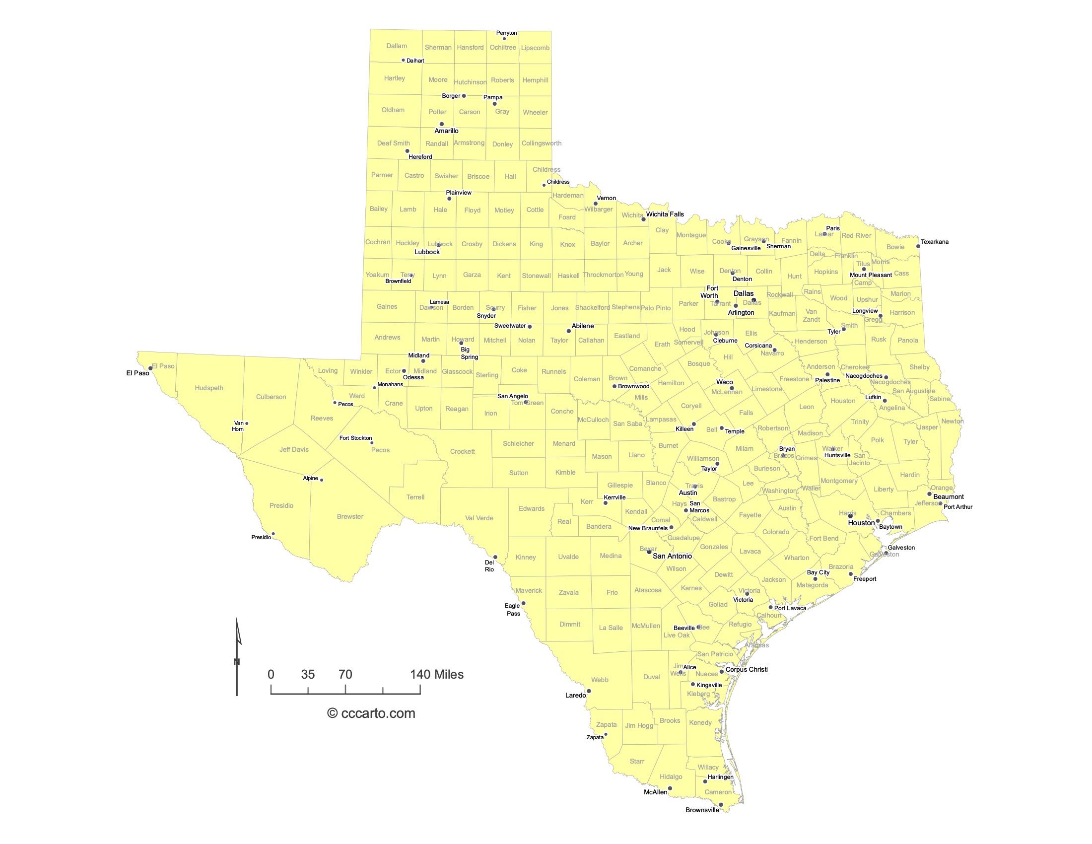
Major Cities of Texas | Texas Cities State Map
In Texas State, most major cities are strategically located near coastal ports, river ports, or along historic transportation routes. Below are examples of each type:
1. Coastal Ports
Houston: The largest city in Texas, Houston is located near the Gulf of Mexico, a major coastal port that has historically facilitated trade and shipping.
Corpus Christi: Located on the Gulf of Mexico, Corpus Christi is a key port city known for its shipyards, fishing industry, and tourism. The Port of Corpus Christi is one of the largest in the U.S., handling significant energy exports.
Galveston: A historic coastal city, Galveston was once the largest port in Texas. Today, it remains important for tourism, shipping, and its deep-water port facilities, as well as its role in the cruise industry.
2. River Ports
San Antonio: Located along the San Antonio River, this historic city is known for its central role in Texas' cultural heritage, including the Alamo and the famous River Walk.
Beaumont: Situated along the Neches River, Beaumont has long been a center for the petroleum and shipping industries. It plays a significant role in oil refining and petrochemical production.
3. Historic Paths or Routes
Dallas: Located at a crossroads of major highways and transportation routes, Dallas has grown into a major economic hub, known for its finance, tech, and commercial industries.
Austin: The capital city of Texas, Austin lies at the intersection of several historic trails and has grown into a major cultural and tech hub. Known for its music festivals and innovation sector, it is also home to many government institutions.
Fort Worth: Originally established as an Army outpost, Fort Worth became a major cattle trading center and now shares a large metropolitan area with Dallas. Its economy is driven by manufacturing, aerospace, and defense industries.
El Paso: Located along the Rio Grande and historic trade routes, El Paso serves as a key point of commerce and trade between the U.S. and Mexico, with a strong military presence and a growing manufacturing sector.
Amarillo: Situated along historic cattle trails and railroads, Amarillo became an important center for ranching, agriculture, and transportation. Today, it plays a significant role in energy, particularly in wind energy development.
Laredo: Positioned on the border with Mexico along the Rio Grande, Laredo is one of the most important inland ports in the United States, with extensive cross-border trade and logistics operations.
Texas Topographic State Map | Shaded Relief
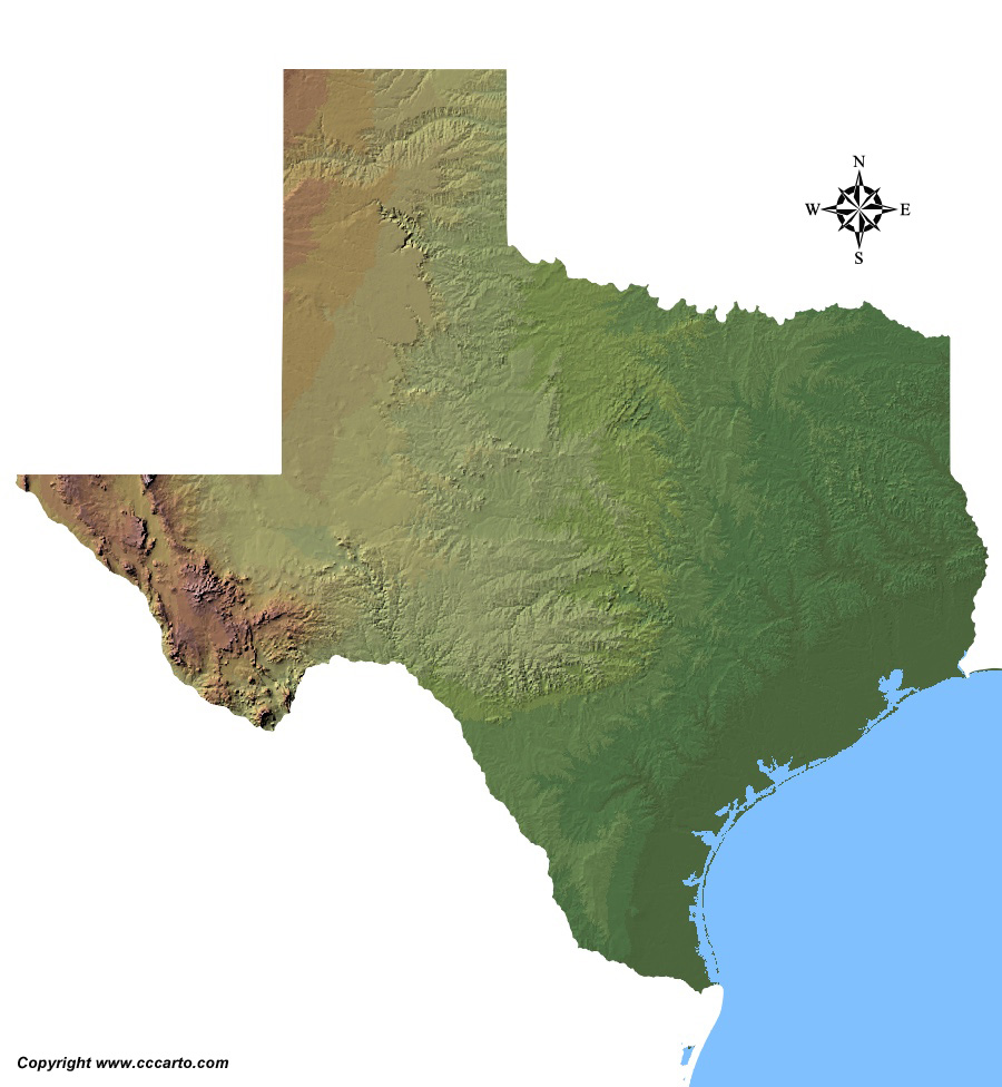
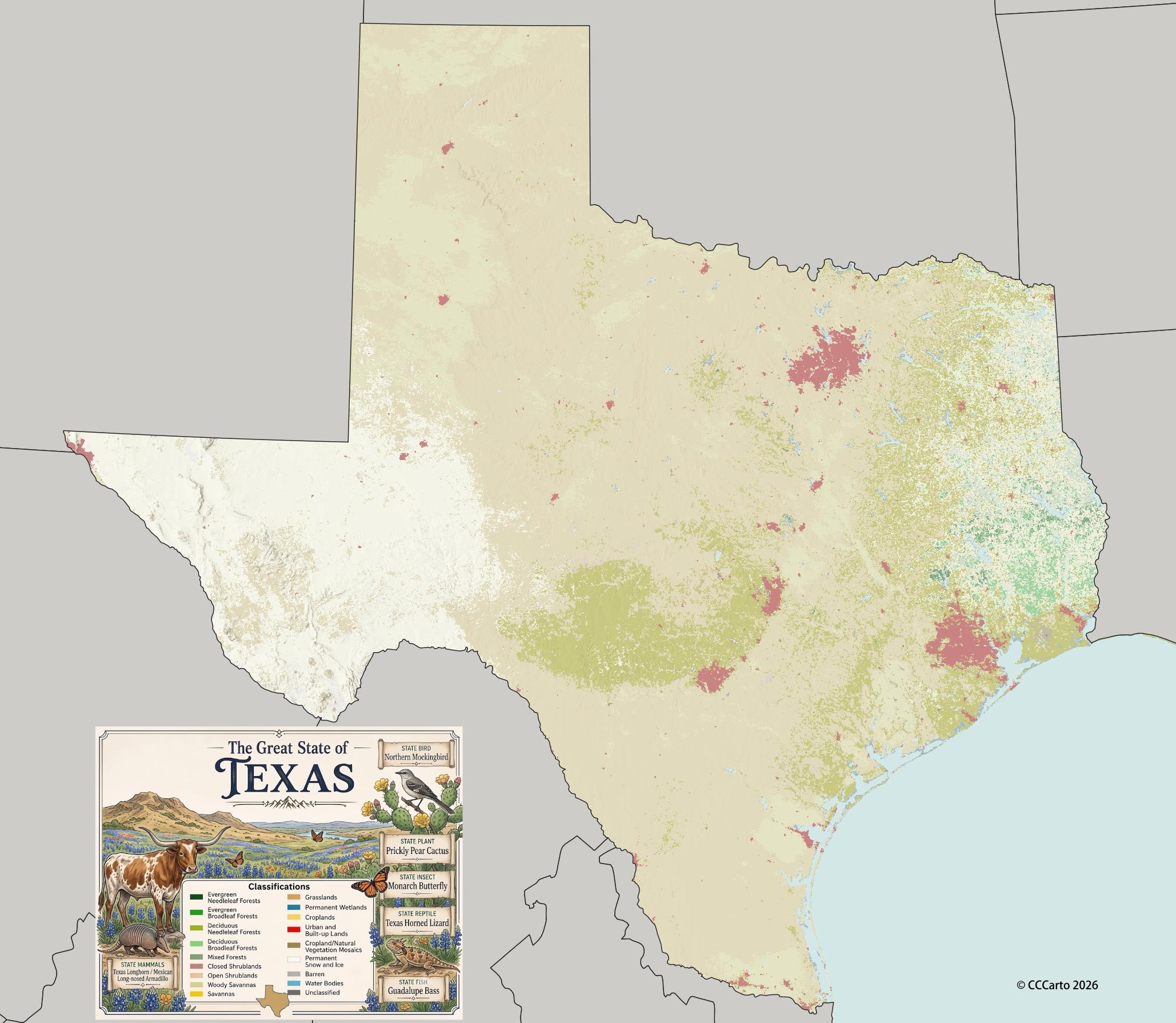
Texas State offers a diverse range of terrains, shaped by its unique geology, climate, and natural features. From the wide open plains to the rugged hill country, and from deserts to coastal regions, the state presents a rich tapestry of landforms.
1. Coastal Lowlands
The eastern edge of Texas features low-lying coastal areas along the Gulf of Mexico. This region includes tidal flats, estuaries, and wetlands. The region is known for its moderate climate and rich soils that support agriculture and oil production.
2. Hill Country
Central Texas is known for the Hill Country, a rugged area with limestone hills, streams, and springs. It is a popular destination for outdoor activities and has a distinct landscape compared to the surrounding plains.
3. Great Plains
The northern region of Texas, known as the Panhandle, is part of the Great Plains. This area is known for its flat, arid landscape, which supports agriculture and wind energy production.
4. Edwards Plateau
Situated in central and west-central Texas, the Edwards Plateau is a region of flat terrain marked by canyons, caves, and limestone formations. This area supports cattle ranching, wildlife habitats, and vineyards due to its dry climate and rugged topography.
5. Piney Woods
The Piney Woods, located in the eastern part of Texas, is a forested region characterized by its dense pine and hardwood forests. This region is home to numerous lakes, rivers, and wetlands, and it supports a thriving timber and forestry industry.
6. Chihuahuan Desert
Stretching across far West Texas, the Chihuahuan Desert is characterized by arid conditions, mountain ranges, and desert vegetation such as yucca and cactus. This area includes Big Bend National Park, which is known for its rugged terrain, deep canyons, and dramatic landscapes.
7. Llano Estacado
The Llano Estacado, also known as the Staked Plains, is a high mesa located in the northwestern part of Texas. It is known for its flat, semi-arid landscape that supports cattle ranching, oil production, and agriculture. This area is part of the Southern Great Plains.
8. Trans-Pecos Region
The Trans-Pecos is a mountainous and desert region located in far West Texas, bordered by the Rio Grande. This region is home to the Davis Mountains, the Guadalupe Mountains, and Big Bend National Park, featuring some of the most rugged and remote landscapes in the state.
9. Balcones Escarpment
This geological fault line runs through Central Texas, separating the coastal plains from the Hill Country and Edwards Plateau. The escarpment features steep cliffs, rolling hills, and numerous springs, rivers, and caves. Cities such as Austin and San Antonio are located near this escarpment.
10. South Texas Plains
Stretching from San Antonio to the Mexican border, this region is characterized by flat terrain, brushlands, and the Rio Grande. The area supports cattle ranching and oil production, and it has a semi-arid climate that transitions into the Chihuahuan Desert.
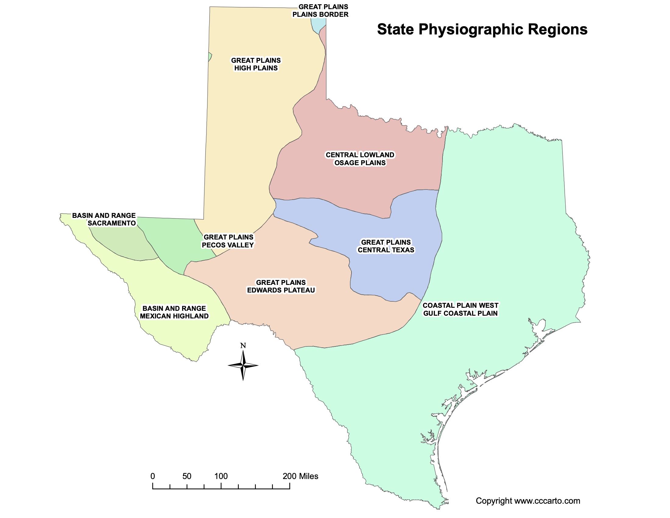
Texas Physiographic Regions State Map
Basin and Range, Mexican Highland
This region in western Texas is characterized by its rugged mountain ranges and arid climate. Known for its desert landscapes and sharp peaks, the area includes parts of the Chihuahuan Desert.
Basin and Range, Sacramento
The Sacramento section of the Basin and Range extends into the far western part of Texas, near the border with New Mexico. It features rugged, isolated mountain ranges and broad valleys, with an arid climate that supports desert vegetation.
Great Plains, Edwards Plateau
The Edwards Plateau is a limestone region located in central Texas, known for its rugged terrain, springs, and canyons. It is part of the Great Plains physiographic region and supports cattle ranching and agriculture, along with numerous vineyards.
Great Plains, Central Texas
Central Texas falls within the southern extension of the Great Plains. This area features rolling hills, fertile soils, and grasslands that support agriculture, particularly cattle ranching and farming. The region also includes the Balcones Escarpment, which divides the plains from the Hill Country.
Great Plains, High Plains
Also known as the Llano Estacado, the High Plains stretch across the Panhandle of Texas. This region is characterized by a flat, semi-arid landscape that supports cattle ranching, agriculture, and oil production. It is part of the southern Great Plains.
Great Plains, Pecos Valley
Located in far West Texas, the Pecos Valley is a lowland area adjacent to the Pecos River. It features flat desert plains and supports agriculture through irrigation from the river. This area is arid and forms part of the larger Chihuahuan Desert.
Great Plains, Plains Border
The Plains Border region is a transitional area between the Central Lowland and the Great Plains. It includes rolling hills, mesas, and dissected plateaus, providing a mix of grasslands and agricultural lands.
Coastal Plain, West Gulf Coastal Plain
The West Gulf Coastal Plain extends along the Gulf Coast of Texas, featuring low-lying flatlands, wetlands, and marshes. This area supports agriculture, oil production, and important ecological habitats for wildlife. It includes major cities like Houston and Corpus Christi.
Central Lowland, Osage Plains
The Osage Plains, part of the Central Lowland, extend into North Texas. This area features rolling plains, fertile soils, and is known for its agricultural output, particularly grain and cattle farming. The region transitions into the Great Plains to the west.
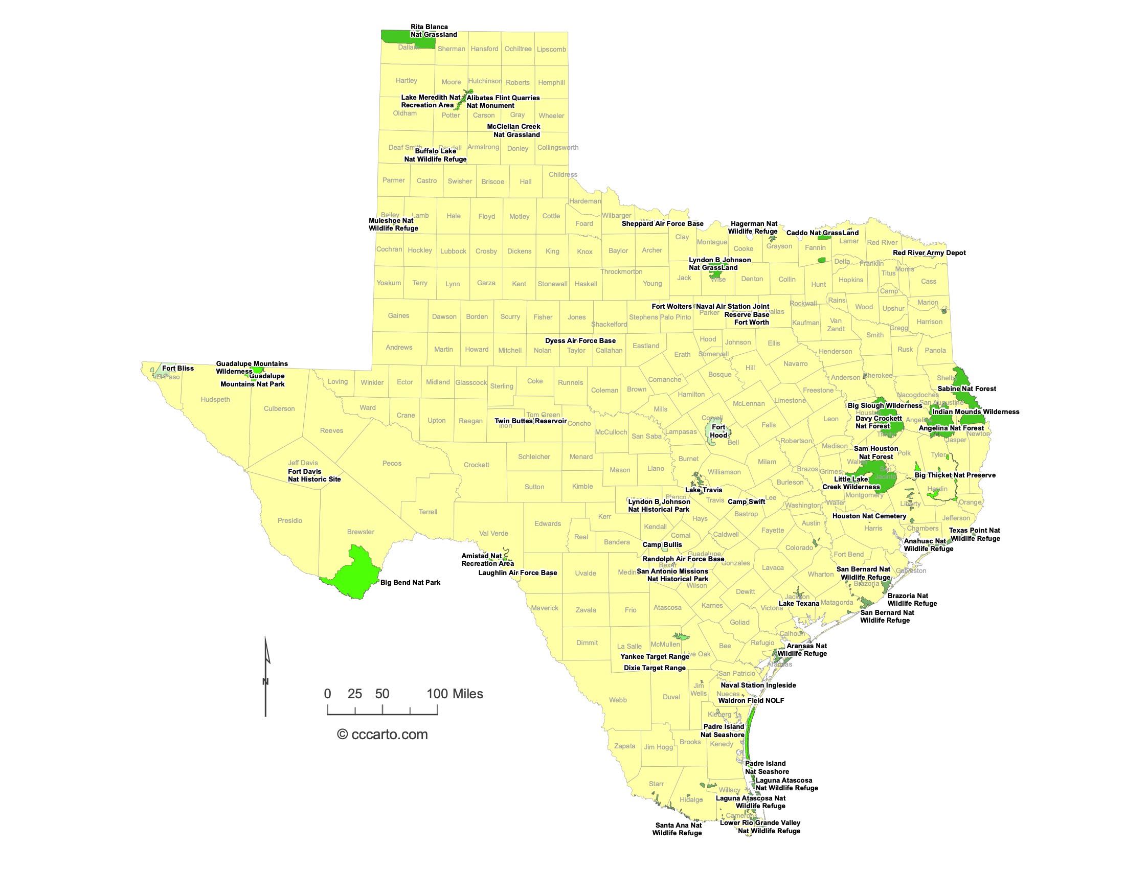
Texas Federal Lands State Map | National Parks & Protected Areas
1. Big Bend National Park
Big Bend National Park is one of the largest protected areas in Texas, encompassing dramatic desert landscapes, mountains, and the Rio Grande River. It is popular for hiking, camping, and stargazing.
2. Davy Crockett National Forest
Located in East Texas, Davy Crockett National Forest spans over 160,000 acres of pine and hardwood forests. It is named after the legendary frontiersman and offers opportunities for hiking, hunting, and camping, with the Big Slough Wilderness as a prominent feature.
3. Sabine National Forest
Sabine National Forest, located along the Texas-Louisiana border, covers 160,000 acres. It features the Toledo Bend Reservoir and is known for its fishing, boating, and wildlife viewing, particularly for birdwatchers.
4. Angelina National Forest
Angelina National Forest is home to the Sam Rayburn Reservoir, one of Texas' largest lakes. Covering 153,000 acres, it offers excellent opportunities for fishing, camping, and hiking. The area also contains the endangered red-cockaded woodpecker habitat.
5. Indian Mounds Wilderness
Located within the Sabine National Forest, the Indian Mounds Wilderness is a 12,369-acre area that offers a more primitive and secluded experience. It is ideal for backcountry hiking and camping, with no developed trails or facilities.
6. Padre Island National Seashore
Padre Island National Seashore stretches along 70 miles of coastline, protecting the longest undeveloped barrier island in the world. It offers beach camping, birdwatching, fishing, and is a nesting ground for endangered Kemp's ridley sea turtles.
7. Aransas National Wildlife Refuge
Aransas National Wildlife Refuge, located on the Texas Gulf Coast, is a critical habitat for the endangered whooping crane. The refuge also supports diverse wildlife, including alligators and migratory birds, making it a popular spot for birdwatching and nature photography.
8. Hagerman National Wildlife Refuge
Hagerman National Wildlife Refuge, located on the shores of Lake Texoma in North Texas, provides habitat for migratory waterfowl, songbirds, and other wildlife. The refuge is popular for birdwatching, hiking, and fishing.
9. Lyndon B. Johnson National Grassland
Located in North Texas, the Lyndon B. Johnson National Grassland covers nearly 20,000 acres. The area offers opportunities for horseback riding, hiking, and camping. It is known for its diverse plant life and grassland ecosystems.
10. Guadalupe Mountains National Park
Guadalupe Mountains National Park is home to the highest point in Texas, Guadalupe Peak, at 8,749 feet. This rugged, mountainous area is popular for hiking and backcountry camping, offering scenic vistas and diverse ecosystems.
11. Amistad National Recreation Area
Located along the U.S.-Mexico border, Amistad National Recreation Area centers around the Amistad Reservoir. It is known for water-based activities like boating, fishing, and scuba diving, as well as ancient Native American rock art sites.
12. Caddo National Grassland
Caddo National Grassland, located in North Texas, covers nearly 18,000 acres and includes the scenic Lake Crockett and Lake Coffee. The area is popular for camping, fishing, and wildlife observation, particularly for birdwatchers.
13. Big Slough Wilderness
Big Slough Wilderness is a 3,455-acre protected area within Davy Crockett National Forest. It offers primitive wilderness experiences, including hiking and wildlife observation, without developed trails or campsites.
14. Sam Houston National Forest
Located north of Houston, Sam Houston National Forest spans over 163,000 acres of pine and hardwood forests. It is a popular destination for hiking, fishing, and camping, with several lakes and the Lone Star Hiking Trail passing through the forest.
15. Big Thicket National Preserve
Big Thicket National Preserve is an ecologically diverse area in East Texas, known for its rich biodiversity and dense forests. Visitors can explore the area's hiking trails, waterways, and unique ecosystems, which include pine forests, swamps, and prairies.
16. San Bernard National Wildlife Refuge
San Bernard National Wildlife Refuge, located along the Texas Gulf Coast, protects wetlands, prairies, and forests. It is an important habitat for migratory birds and is popular for birdwatching and wildlife observation.
17. Brazoria National Wildlife Refuge
Brazoria National Wildlife Refuge, also located on the Gulf Coast, provides a crucial habitat for migratory birds and other wildlife. It features freshwater and saltwater marshes, as well as prairies, and is popular for wildlife viewing and fishing.
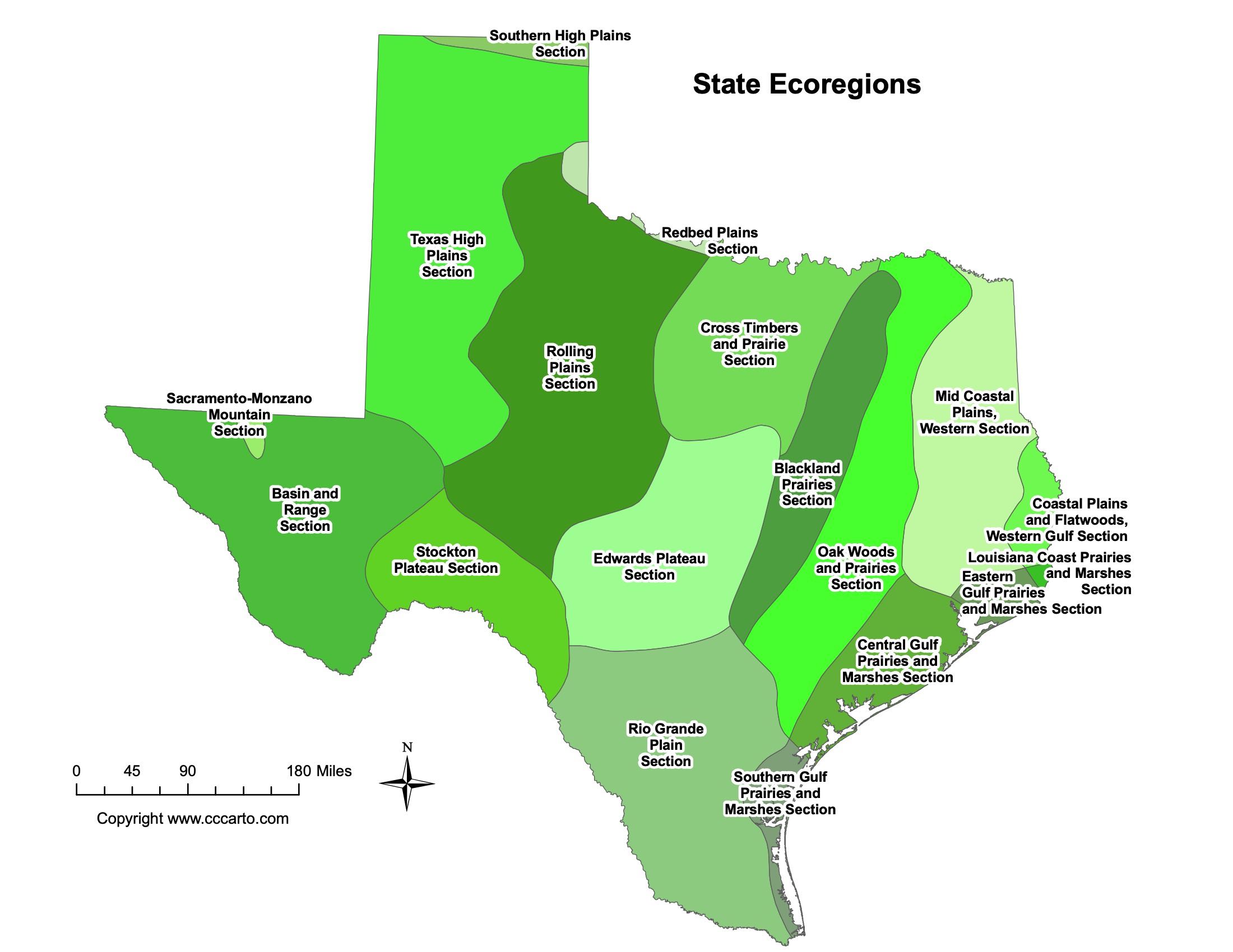
Texas Ecoregions State Map | EPA Ecological Zones
Cross Timbers and Prairie Section
This ecoregion covers part of northern Texas and is characterized by its mix of forests and prairies, with oak woodlands being the dominant vegetation type.
Stockton Plateau Section
This region lies west of the Edwards Plateau and features a rugged landscape with limestone outcrops, canyons, and springs. Vegetation includes juniper-oak woodlands and grasslands.
Basin and Range Section
The Basin and Range section is located in far western Texas. It consists of desert valleys separated by isolated mountain ranges. Vegetation is sparse and adapted to arid conditions, with species such as creosote bush, yucca, and ocotillo.
Sacramento-Monzano Mountain Section
This section includes part of the Trans-Pecos region, extending into New Mexico. It features mountain ranges and valleys, with pine-oak forests and grasslands at higher elevations and desert scrub at lower elevations.
Mid Coastal Plains, Western Section
This section covers the western part of Texas's coastal plains and is characterized by prairies, oak savannas, and wetlands. It supports diverse wildlife, including migratory birds and coastal species.
Louisiana Coast Prairies and Marshes Section
Located along the eastern coast of Texas, this section features extensive marshlands, coastal prairies, and estuaries. It is important for waterfowl and marine life and is vulnerable to coastal erosion and storm surge.
Old Woods and Prairies Section
This region, situated in central and northeastern Texas, is characterized by a mix of wooded areas and prairies. Dominant vegetation includes hardwood forests and native grasses. It has a humid climate and fertile soils.
Rio Grande Plain Section
The Rio Grande Plain, in southern Texas, is a flat to gently rolling region that supports thorny shrublands, mesquite, and grasses. It is an important agricultural area, with irrigated crops along the Rio Grande.
Southern Gulf Prairies and Marshes Section
This section lies along the Gulf Coast and includes coastal wetlands, salt marshes, and prairies. It supports diverse wildlife, including waterfowl and fish, and plays a key role in the region's fisheries and tourism.
Rolling Plains Section
The Rolling Plains section covers north-central Texas and features gently rolling hills, grasslands, and scattered woodlands. This area is used primarily for agriculture, including cotton, wheat, and livestock production.
About CCCarto – Texas State Maps Creator
CCCarto has been producing professional digital and GIS maps for large companies, government agencies, and educational institutions since 1988. With over 35 years of cartographic experience, our Texas state maps are designed to the highest standards of accuracy, clarity, and usability.
Our map collection spans counties, cities, federal lands, ecoregions, physiographic regions, topographic relief, and more — giving students, researchers, educators, planners, and curious explorers the best Texas state map resources available online. Every map is optimized for both screen viewing and letter-size printing.
Explore our full U.S. State Maps collection, or browse our Geology Maps, Travel Maps, and Energy Maps.