

Hawaii State Maps | Complete Map Collection
These maps show Hawaii's Counties, Cities, Federal Areas, NOAA Refuges, and Ecoregions. These high-resolution Hawaii maps are and available for download.
Map Profile
- Format: JPEG
- Color: RGB
- Resolution: ~72 DPI
- Typical image size: ~1300 1700 px
- Paper size: Letter (8.5 11 inches)
- Layouts: Portrait and Landscape
- File size: ~100500 KB
Print tip: In your print dialog select Letter (8.511), choose Portrait or Landscape, and use Fit to Page (or Scale - to fit).

Hawaii County Facts
Hawaii has 5 counties (including Kalawao). Counties were established by the 1905 County Act; the City & County of Honolulu (covering Oahu) was organized in 1907.
- Number of counties: 5 State of Hawaii (counties) overview
- First & last established: County Act (1905) created Hawaii, Maui, Kauai, Oahu; City & County of Honolulu formed 1907; Kalawao remains separate
- How borders are set: Island-based county lines (coastlines, district histories) rather than PLSS State portal
- Highest & lowest county (elev.): Highest point Mauna Kea in Hawaii County; lowest is sea level across coastal counties USGS
- Most & least populated: Most: City & County of Honolulu; Least: Kalawao County
- Least & most developed (proxy = density): Most dense: Honolulu; least dense: Kalawao
- Most geographically diverse county (reasoned pick): Hawaii County (snowy Mauna Kea, Mauna Loa lava deserts, rainforests, beaches)

Hawaii County Sizes State Map
Smallest County in Hawaii State
Kalawao County: 16 sq miles
Largest County in Hawaii State
Hawaii County: 4050 sq miles
Mean and Median Area of Counties in Hawaii State
Mean Area: 2247.5 sq miles
Median Area: 2325.0 sq miles


Major Cities/Towns of Hawaii State and Their Locations
In Hawaii, major cities and towns are typically located along the coasts or in significant valleys. Below are examples of each:
1. Coastal Cities
Honolulu: The largest city and state capital, Honolulu is located on Oahu and is a major hub for trade, tourism, and government.
Kahului: A major city on Maui, Kahului is a central location for tourism and local industry.
Kaneohe: A town on the windward side of Oahu, Kaneohe is known for its lush scenery and proximity to Kaneohe Bay.
Kailua (Oahu): Located on the windward side of Oahu, Kailua is a popular destination for beaches and local culture.
Pearl City: Situated near Pearl Harbor on Oahu, Pearl City is a significant residential and commercial area.
Waialua: A small, quiet town on Oahu's North Shore, Waialua is known for its rural landscape and proximity to beaches.
Haleiwa: The surfing capital of the North Shore of Oahu, Haleiwa is famous for its laid-back atmosphere and surf culture.
Makaha: A town on the leeward side of Oahu, Makaha is known for its beautiful beach and great surf spots.
Kapolei: Located on Oahus west side, Kapolei is a rapidly growing city known as the "Second City" of Oahu.
Lahaina: A historic town on Maui, Lahaina is a major tourism hub with shops, galleries, and restaurants.
Kaanapali: Located on Maui, Kaanapali is famous for its resorts, beaches, and luxury shopping.
Kualapuu: A small town on Molokai, Kualapuu is known for its rural setting and agricultural roots.
Wailea: A luxury resort community on Maui, Wailea is known for its high-end resorts, golf courses, and beaches.
Poipu: A major resort area on Kauai's south shore, Poipu is known for its sunny weather and beautiful beaches.
Koloa: A historic sugar town on Kauai, Koloa is a popular destination for exploring local history and nearby Poipu Beach.
Hanalei: Located on Kauais North Shore, Hanalei is famous for its scenic beauty and nearby Hanalei Bay.
Princeville: A luxury resort community on Kauais North Shore, Princeville is known for its golf courses and stunning views of the Pacific.
Lihue: The county seat of Kauai, Lihue is the commercial and transportation hub of the island, home to the main airport and seaport.
2. Inland and Coastal Cities
Kailua (Hawaii Island): Also known as Kailua-Kona, this town on the west coast of Hawaii Island is famous for its beaches and Ironman Triathlon.
Hilo: Located on the east coast of Hawaii Island, Hilo is known for its lush environment, waterfalls, and proximity to Hawaii Volcanoes National Park.
Waimea: Also known as Kamuela, this town on Hawaii Island is renowned for its paniolo (Hawaiian cowboy) culture and proximity to ranchlands.
Kahaluu-Keauhou: A coastal community on the west coast of Hawaii Island, known for its historical significance and beautiful snorkeling spots.
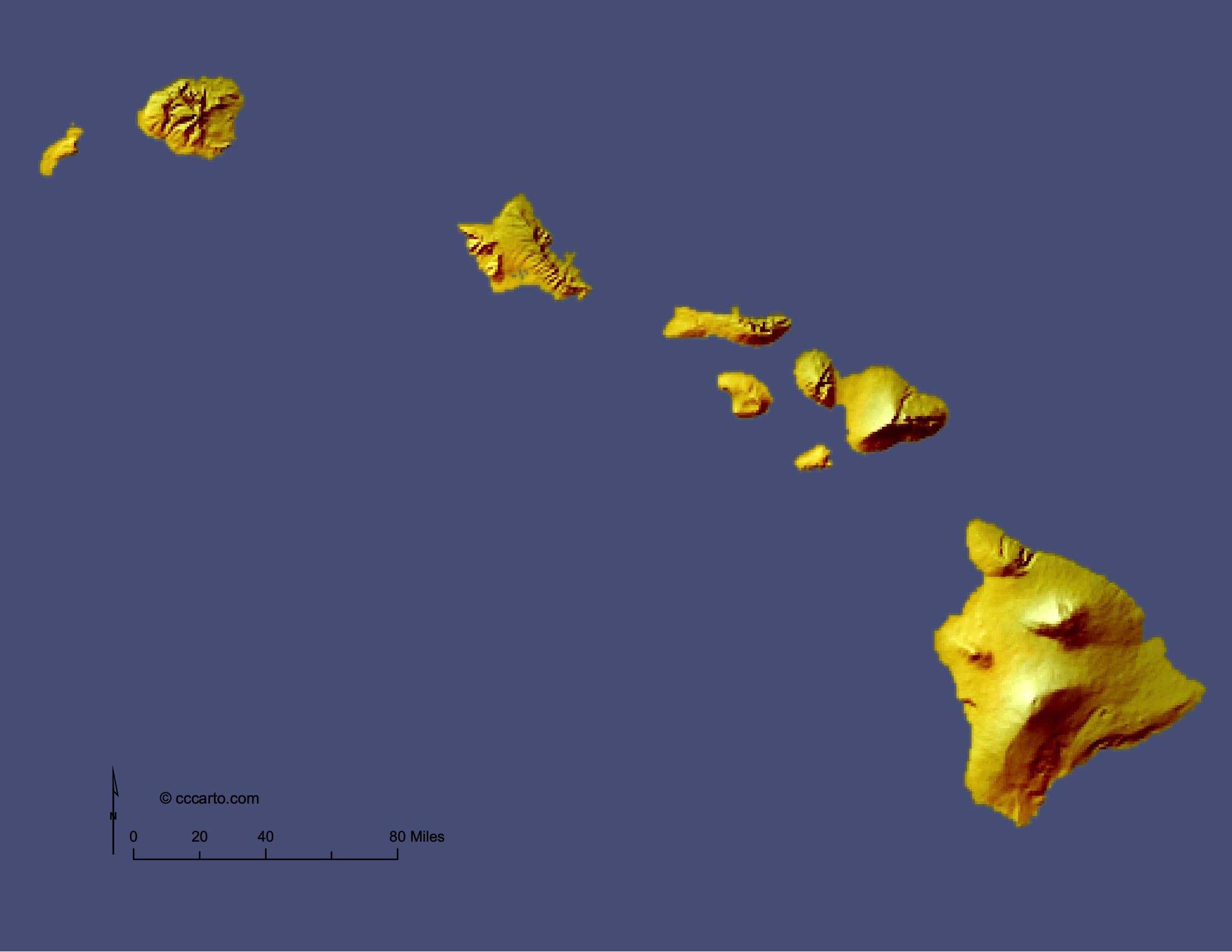

Hawaii Topographic State Map | Shaded Relief State
Hawaiis topography is one of the most unique and diverse in the world, shaped by millions of years of volcanic activity. The state's islands each have distinct landforms, ranging from towering volcanic peaks to lush valleys and expansive coastal plains. Below is a topographic overview of Hawaiis key geographic regions:
1. Volcanic Peaks
The Hawaiian Islands are volcanic in origin, with some of the most famous volcanoes in the world. On the Big Island (Hawaii Island), Mauna Loa and Mauna Kea are two of the tallest mountains on Earth when measured from their base on the ocean floor. Mauna Loa remains an active volcano, while Mauna Kea is dormant and home to world-renowned astronomical observatories. On Maui, Haleakal is another towering volcanic peak that offers stunning views of the sunrise and is a popular destination for hiking and stargazing.
2. Coastal Lowlands
All of the Hawaiian Islands feature low-lying coastal areas, often characterized by sandy beaches, coral reefs, and bays. The islands' coastlines are dotted with picturesque beaches like Waikiki Beach on Oahu, Kaanapali Beach on Maui, and Poipu Beach on Kauai. These coastal lowlands are key to Hawaiis tourism industry and are home to the majority of its cities and towns. The coastal areas are also fringed with lava fields on the Big Island, where recent volcanic activity has dramatically altered the landscape.
3. Valleys and Canyons
The islands' interior regions often feature deep, lush valleys formed by erosion. On Kauai, the Waimea Canyon, often called the "Grand Canyon of the Pacific," is a stunning 10-mile long canyon with depths of up to 3,000 feet. It showcases multicolored layers of rock, waterfalls, and verdant vegetation. The windward sides of the islands, such as Oahus Koolau Range, also feature dramatic valleys carved by rain and streams, like the scenic Nu'uanu Valley near Honolulu.
4. Shield Volcanoes
Hawaii's shield volcanoes are massive, gently sloping landforms created by successive lava flows. The Big Island is home to Kilauea, one of the most active volcanoes on Earth. This shield volcano has created large lava plains and altered the island's topography through frequent eruptions. The gradual slopes of the volcanoes give the islands their characteristic shape and create a broad diversity of habitats from sea level to high altitudes.
5. Cliffs and Sea Cliffs
Hawaii features some of the tallest sea cliffs in the world. On Molokai, the northern coastline is marked by dramatic cliffs that plunge up to 3,900 feet into the ocean. These cliffs are the result of volcanic activity and erosion over millions of years. On the island of Kauai, the N Pali Coast is another striking example, with steep, green cliffs that rise from the ocean and are accessible by boat or hiking.
6. Lava Fields
The Big Islands southeast region is dominated by recent lava flows, particularly around the Hawaii Volcanoes National Park area. These rugged, black lava fields are continually shaped by eruptions from Kilauea, covering vast areas of land and reaching the ocean to create new landmass. The Kalapana region is a notable area that has been repeatedly reshaped by lava over recent decades.
7. Rainforests and Wetlands
Hawaiis tropical rainforests are primarily found on the windward sides of the islands, where the moist trade winds deposit rainfall. The Big Islands Hmkua Coast and Kauais Alakai Swamp are examples of lush, wet ecosystems. These regions are known for their biodiversity, hosting many native plants and animals. The rainforest regions also feature waterfalls, such as the famous Akaka Falls on the Big Island and Wailua Falls on Kauai.
8. Coral Reefs and Coastal Ecosystems
The coastal waters of Hawaii are home to vibrant coral reefs that support a rich array of marine life. The reefs form a barrier along many shorelines, creating calm lagoons that are ideal for swimming, snorkeling, and fishing. Notable reef ecosystems include the Molokini Crater off the coast of Maui, a popular diving and snorkeling spot, and the protected reefs of Hanauma Bay on Oahu.


NOAA Refuges, National Monuments, and Reserves of Hawaii State
This section includes protected areas that are managed for conservation, scientific research, and preservation of Hawaiis natural and cultural resources. These areas often have restrictions, including no-fishing zones, to protect fragile ecosystems and marine life:
- Johnston Island National Wildlife Refuge: Located about 750 nautical miles southwest of Hawaii, Johnston Island is a remote atoll with significant importance as a refuge for migratory seabirds and marine life. Access to the area is restricted, and fishing is prohibited to protect the reef ecosystems and the breeding grounds of seabirds.
- Pacific Remote Islands Marine National Monument: Encompassing some of the most remote U.S. islands in the Pacific, this marine national monument includes seven islands and atolls. It covers nearly 495,000 square miles of marine environment, making it one of the largest marine conservation areas in the world. Fishing is prohibited within this monument to preserve coral reefs, seabird colonies, and endangered marine species like sea turtles and sharks.
- Papahnaumokukea Marine National Monument: One of the largest marine conservation areas globally, Papahnaumokukea spans 582,578 square miles in the Northwestern Hawaiian Islands. This UNESCO World Heritage site protects an array of marine habitats, coral reefs, and endangered species such as the Hawaiian monk seal and green sea turtles. Fishing is banned in the area to maintain the ecological integrity of this pristine marine environment.
- Midway Atoll National Wildlife Refuge: Located within the Papahnaumokukea Marine National Monument, Midway Atoll serves as a critical habitat for over three million seabirds, including the endangered Laysan albatross. The atoll is a no-fishing zone, and access is heavily restricted to scientific and conservation purposes to protect the surrounding coral reefs and bird populations.
- Pearl Harbor National Wildlife Refuge: Established in 1972, this refuge protects wetland habitats around Pearl Harbor on Oahu. The wetlands are vital for endangered Hawaiian waterbirds such as the Hawaiian coot and Hawaiian stilt. Although not a marine monument, this area contributes to the protection of wetland ecosystems and is essential for Hawaii's avian wildlife. Fishing is not allowed in these sensitive areas to ensure the preservation of the wetland habitats.
- Pukohol Heiau National Historic Site: Located on the Big Island, this site is culturally significant as the location of one of the last major temples built in Hawaii. Although it is not a wildlife refuge, the surrounding waters are part of the protected Puukohol Heiau Marine Life Conservation District, where fishing is regulated to maintain the health of the coral reef ecosystems and marine species.
No-Fishing Areas Around the Hawaiian Islands
In addition to these national monuments and refuges, several designated no-fishing areas (Marine Protected Areas) exist around Hawaii to conserve marine biodiversity and protect vulnerable ecosystems:
- Hanauma Bay Marine Life Conservation District (Oahu): One of the most popular snorkeling destinations in Hawaii, Hanauma Bay is a no-fishing zone established to protect its coral reefs and abundant marine life. The bay's marine ecosystem is home to a variety of fish species, including parrotfish, triggerfish, and butterflyfish, all of which benefit from the conservation measures.
- Molokini Shoal Marine Life Conservation District (Maui): Molokini Crater, a partially submerged volcanic caldera, is a no-fishing area that draws snorkelers and divers from around the world. The waters around the crater are home to vibrant coral reefs and an array of marine species, including manta rays, moray eels, and sharks, all of which thrive under the no-fishing restrictions.
- Kealakekua Bay Marine Life Conservation District (Big Island): Kealakekua Bay, famous for its clear waters and historical significance, is also a no-fishing zone. The bay's underwater ecosystem, including coral gardens and tropical fish, is protected to preserve its biodiversity and to support sustainable tourism.
- Honolua Bay Marine Life Conservation District (Maui): Honolua Bay, a favorite spot for surfers and snorkelers, is a no-fishing zone that helps protect the coral reefs and marine life along Maui's northwest coast. The protection of the bay ensures a healthy ecosystem for species like green sea turtles and the endemic Hawaiian spinner dolphin.
These protected areas and no-fishing zones play a crucial role in maintaining the biodiversity and ecological health of Hawaiis marine and terrestrial environments. By preserving fragile ecosystems, they ensure that future generations can continue to experience the natural beauty of the Hawaiian Islands.

Federal Lands in Hawaii State
1. Hawaii Volcanoes National Park
This park, located on the Big Island, is home to two of the worlds most active volcanoes: Kilauea and Mauna Loa. It offers visitors the chance to witness ongoing volcanic activity and explore diverse ecosystems, from lava deserts to lush rainforests. The park also includes petroglyph fields, lava tubes, and scenic drives through volcanic landscapes.
2. Haleakal National Park
Located on Maui, Haleakal National Park is centered around the massive Haleakal Crater, offering visitors breathtaking views, especially at sunrise. The park protects a variety of unique habitats, from tropical rainforests to alpine deserts, and is home to the endangered Hawaiian goose (nn) and the silversword plant. Visitors can explore hiking trails, campgrounds, and the scenic drive to the summit.
3. South Kona Forest Reserve
The South Kona Forest Reserve, located on the Big Island, is a critical area for the conservation of native Hawaiian flora and fauna, particularly in its high-elevation cloud forests. The reserve supports endangered species like the Hawaiian honeycreeper and offers opportunities for birdwatching and hiking while protecting some of the state's most pristine forests.
4. Pearl Harbor National Memorial
Pearl Harbor is not only a historical site but also a National Memorial that commemorates the attack on December 7, 1941, and honors the lives lost. The site includes the USS Arizona Memorial, visitor center, and museums. While not a traditional wilderness area, Pearl Harbor is one of the most visited federal landmarks in Hawaii, offering an important historical perspective.
5. Kalaupapa National Historical Park
Located on the remote Kalaupapa Peninsula on Molokai, Kalaupapa National Historical Park preserves the history of the leprosy (Hansens disease) settlement that was established in the 19th century. Accessible by hiking, mule ride, or plane, the park provides a unique historical experience while showcasing stunning sea cliffs and natural beauty.
6. Hanalei National Wildlife Refuge
Hanalei National Wildlife Refuge, situated on the north shore of Kauai, protects important wetland habitats critical to the survival of endangered Hawaiian birds like the Hawaiian stilt and coot. The refuge is located in the Hanalei Valley and provides visitors with scenic views of taro fields, wetlands, and surrounding mountains.

Hawaii Ecoregions State Map | EPA Ecological Zones State
Hawaiian Islands Section
The Hawaiian Islands ecoregion includes diverse landscapes, from dry coastal areas to wet, mountainous regions. Each island supports unique ecosystems found nowhere else on Earth, including tropical rainforests, grasslands, and coral reefs. Conservation efforts across the islands are critical, as many species and ecosystems are endangered. Significant areas have been set aside as national parks, wildlife refuges, and reserves to protect these fragile environments. Below is a closer look at the ecological features of each major island:
Hawaii (Big Island)
The Big Island is home to a wide range of ecosystems due to its sheer size and varying elevations. The island features everything from dry lava deserts along its coasts to tropical rainforests in places like the Hmkua Coast. The Big Island is also known for its active volcanoes, particularly in Hawaii Volcanoes National Park, which hosts Kilauea and Mauna Loa. The island's volcanic landscapes are home to unique lava tube ecosystems and provide critical habitat for native species like the Hawaiian hawk ('io) and Hawaiian goose (nn). The South Kona Forest Reserve protects high-elevation cloud forests, while coral reefs around the island, particularly at Kealakekua Bay, support a variety of marine life, including dolphins, manta rays, and tropical fish.
Maui
Maui's diverse landscapes include the lush rainforests of East Maui, the arid lava fields of the Haleakal Crater, and the scenic coastal lowlands. Haleakal National Park, which includes the massive dormant volcano of the same name, is home to the endangered silversword plant and native birds like the nn. Maui's coral reefs, such as those found at Molokini Shoal Marine Life Conservation District, support vibrant marine ecosystems. The western part of the island, including areas like the Honolua Bay Marine Life Conservation District, offers excellent snorkeling and critical reef conservation areas. Additionally, the islands diverse habitats include dry forests and unique shrubland ecosystems found along its leeward coastlines.
Oahu
Oahu, home to the state capital of Honolulu, is the most populated island but still boasts a wealth of natural ecosystems. The island features wet mountain ranges, including the Koolau Range, which is covered in lush rainforest and home to waterfalls such as those in the Nuuanu Valley. Oahu's coral reefs, especially around Hanauma Bay, are some of the most visited and protected in the state. These reefs are part of the Hanauma Bay Marine Life Conservation District, which helps preserve marine biodiversity. The Waianae Range on the west side of the island provides habitat for native species and offers stunning views of the dry valleys and coastal plains. Pearl Harbor and the adjacent wetlands, managed as part of the Pearl Harbor National Wildlife Refuge, are essential for the conservation of native waterbirds.
Kauai
Kauai, often called the "Garden Island," is renowned for its lush rainforests, waterfalls, and dramatic landscapes. The island is home to the wettest spot on Earth, Mount Waialeale, which feeds the island's rivers and waterfalls. Waimea Canyon, known as the "Grand Canyon of the Pacific," offers stunning views of deep gorges and multicolored cliffs. The Na Pali Coast is another iconic feature, with its steep sea cliffs and isolated beaches. Kauais wetlands, such as the Hanalei National Wildlife Refuge, play a critical role in protecting endangered Hawaiian birds like the Hawaiian stilt and coot. The coral reefs around Poipu and Hanalei Bay are important ecosystems for marine life, providing habitat for fish, sea turtles, and monk seals.
Molokai
Molokai is one of the least developed islands in Hawaii, known for its rich Hawaiian culture and dramatic landscapes. The island's northern coastline is dominated by some of the tallest sea cliffs in the world, rising up to 3,900 feet above the ocean. Kalaupapa National Historical Park, located on a remote peninsula, preserves the history of the leprosy (Hansen's disease) settlement and offers spectacular views of the cliffs and coastline. The islands wetlands, particularly at Kakahaia National Wildlife Refuge, provide important habitats for endangered waterbirds. Molokais coral reefs, stretching along its south shore, are some of the most extensive in Hawaii, offering vital habitats for marine species while supporting sustainable fishing practices.
Lanai
Lanai, once known for its pineapple plantations, is now famous for its luxury resorts and outdoor adventures. The islands landscape is a mix of dry forests, grasslands, and coastal areas. Lanais coastline features important marine environments, including tide pools and coral reefs that support species such as the Hawaiian green sea turtle and spinner dolphins. Lanaihale, the islands highest peak, is surrounded by a dry forest that is home to native plants and birds.
Kahoolawe
Kahoolawe, the smallest of the main Hawaiian Islands, has a unique history as a former military training ground. Efforts are underway to restore the islands degraded ecosystems, particularly its native dryland forests and coastal habitats. The island is surrounded by vibrant coral reefs that support marine life, though access is restricted due to ongoing restoration and unexploded ordnance. Kahoolawe is a sacred site for Native Hawaiian cultural practices, and conservation efforts aim to restore both its ecological and cultural heritage.
Efforts to conserve the ecosystems across the Hawaiian Islands are ongoing, with national parks, wildlife refuges, and marine reserves protecting unique species and habitats. Each islands diverse landscape contributes to Hawaiis global ecological importance, making it a vital region for conservation and environmental stewardship.
About CCCarto – Hawaii State Maps Creator
CCCarto has been producing professional digital and GIS maps for large companies, government agencies, and educational institutions since 1988. With over 35 years of cartographic experience, our Hawaii state maps are designed to the highest standards of accuracy, clarity, and usability.
Our map collection spans counties, cities, federal lands, ecoregions, physiographic regions, topographic relief, and more — giving students, researchers, educators, planners, and curious explorers the best Hawaii state map resources available online. Every map is optimized for both screen viewing and letter-size printing.
Explore our full U.S. State Maps collection, or browse our Geology Maps, Travel Maps, and Energy Maps.