

Virginia State Maps | Complete Map Collection
Virginia State Maps: Detailed Maps for Counties, Cities, Federal Areas, Physiographic & Ecoregions
Welcome to our comprehensive collection of Virginia State Maps, meticulously curated to provide detailed, high-resolution visualizations of the state’s geography, political boundaries, and natural regions. These maps are designed for students, researchers, planners, and anyone seeking an in-depth visual reference.
- Counties and Cities: Clearly defined county boundaries and major cities for planning, education, and demographic reference.
- Federal Areas: National parks, forests, monuments, wildlife refuges, military installations, and other federally managed lands.
- Physiographic Regions: Major landforms and terrain features such as mountains, plains, valleys, plateaus, and coastal areas.
- Ecoregions: Ecological zones representing forests, grasslands, deserts, wetlands, and other biodiversity regions.
Map Profile
- Format: JPEG
- Color: RGB
- Resolution: ~72 DPI
- Typical image size: ~1300 × 1700 px
- Paper size: Letter (8.5 × 11 inches)
- Layouts: Portrait and Landscape
- File size: ~100–500 KB
Print tip: In your print dialog select Letter (8.5×11), choose Portrait or Landscape, and use Fit to Page (or Scale - to fit).
Virginia Counties Interesting Facts
Virginia has 95 counties + 38 independent cities; Northern Virginia counties dominate population.
- Number of counties: 95 + independent cities — List
- First & last established: Shires (1634); last created Dickenson (1880) — Newberry Atlas
- Highest & lowest county: Highest at Mt. Rogers (Grayson); lowest sea level (Accomack) — USGS
- Most & least populated: Most: Fairfax; Least: Highland (profile)
- Least & most developed (proxy): Most: Fairfax; Least: Highland (links above)
- Most geographically diverse: Augusta County (Blue Ridge, Shenandoah Valley)
- Strangest-shaped county: Accomack County (long Eastern Shore)
- State’s Biggest Commodity: Broilers & turkeys lead. USDA ERS
- Largest Private Employer: Walmart (statewide compendium). Patch/24/7 Wall St.
- Top 3 Non-English Languages: Spanish, Korean, Chinese — DataUSA
About CCCarto – Virginia State Maps Creator
CCCarto has been producing professional digital and GIS maps for large companies, government agencies, and educational institutions since 1988. With over 35 years of cartographic experience, our Virginia state maps are designed to the highest standards of accuracy, clarity, and usability.
Our map collection spans counties, cities, federal lands, ecoregions, physiographic regions, topographic relief, and more — giving students, researchers, educators, planners, and curious explorers the best Virginia state map resources available online. Every map is optimized for both screen viewing and letter-size printing.
Explore our full U.S. State Maps collection, or browse our Geology Maps, Travel Maps, and Energy Maps.
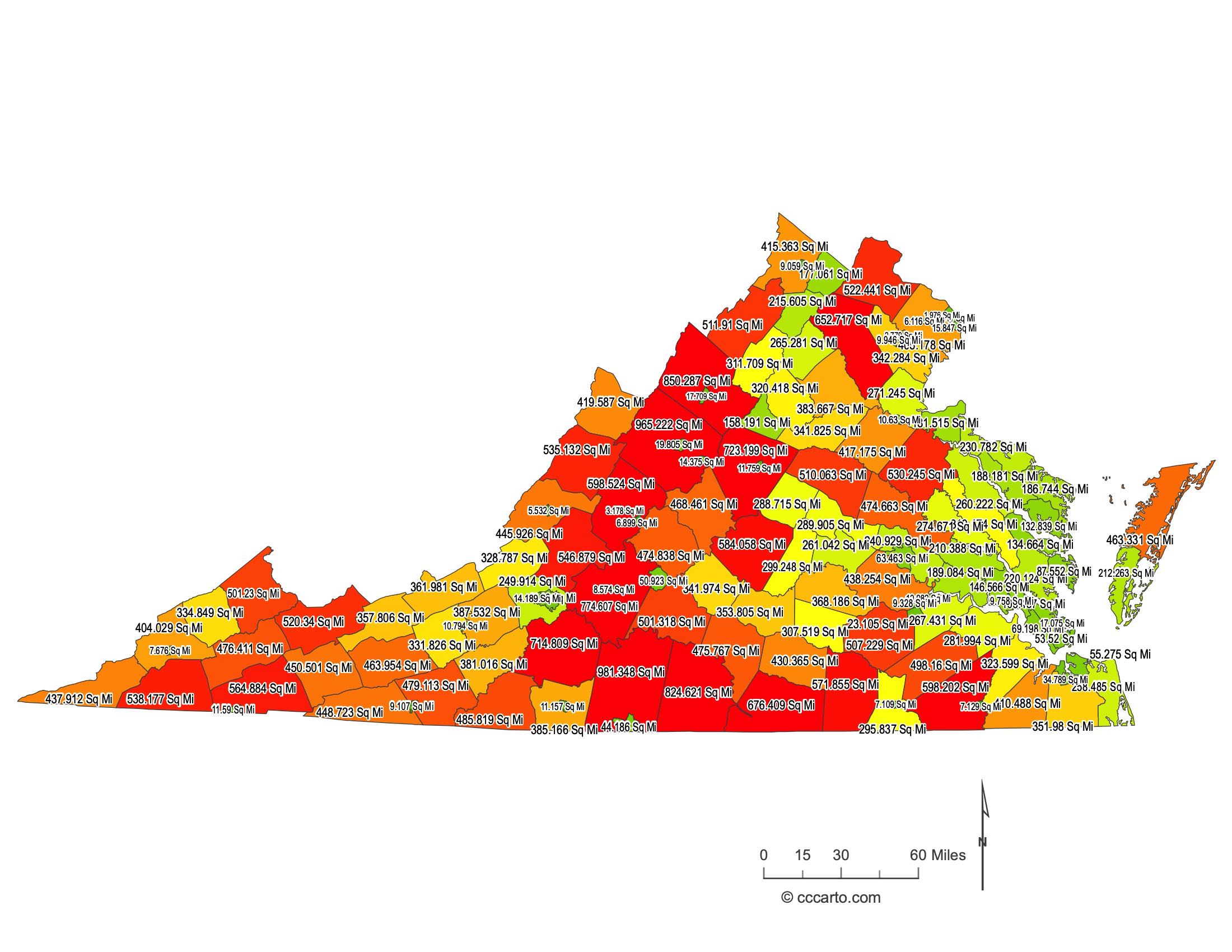
Virginia County Sizes State Map
Smallest County in Virginia State
Arlington County: 26 sq miles
Largest County in Virginia State
Pittsylvania County: 981 sq miles
Mean and Median Area of Counties in Virginia State
Mean Area: 310 sq miles
Median Area: 345 sq miles
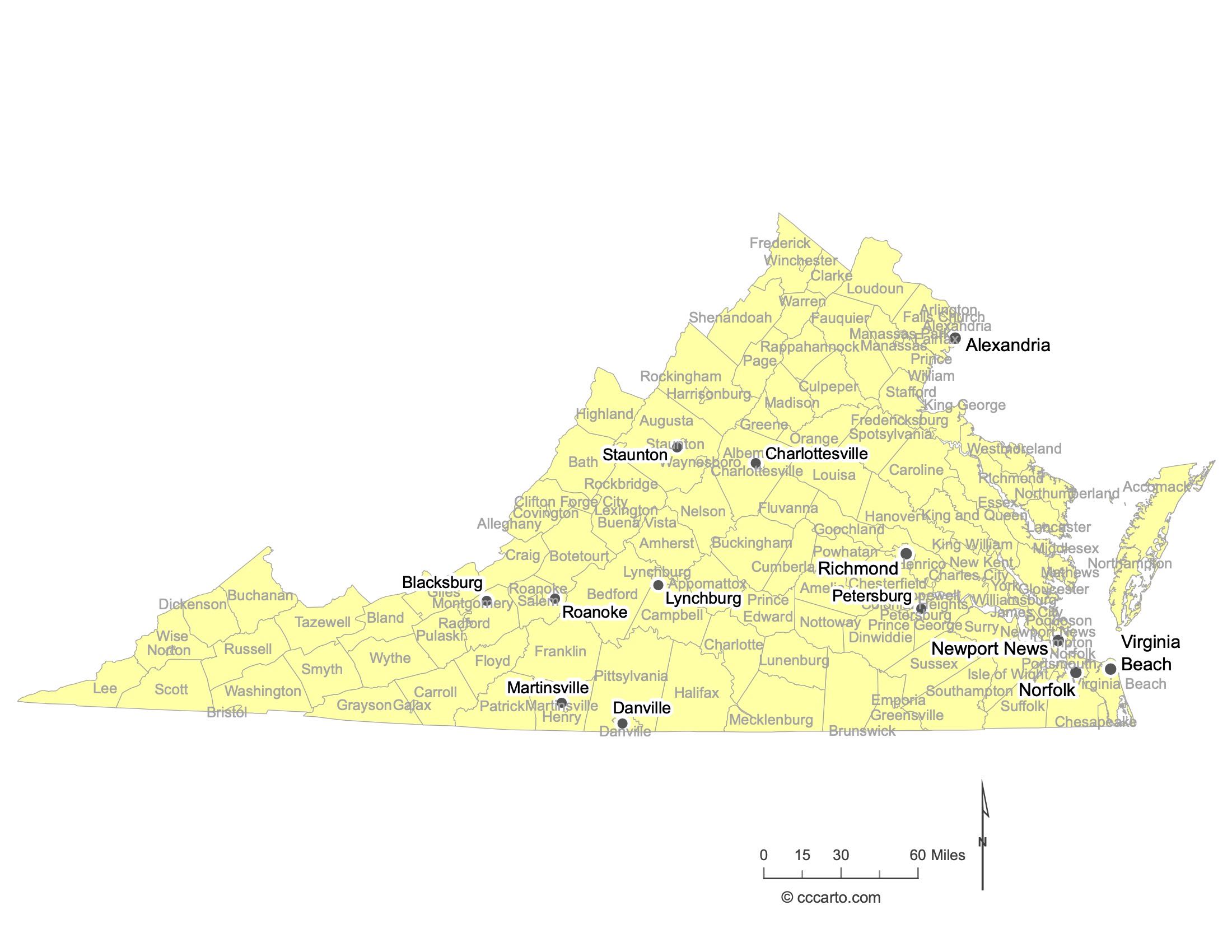
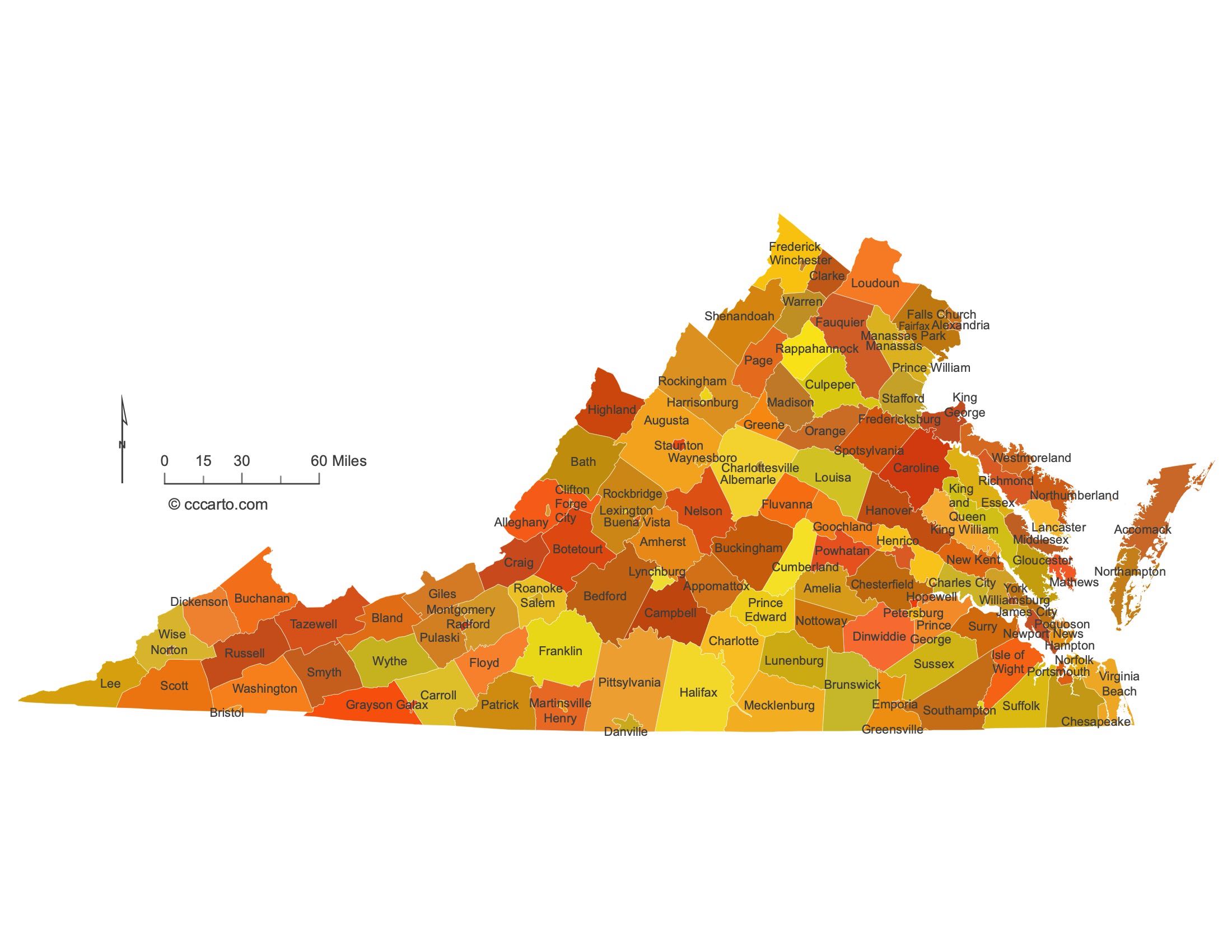
Major Cities of Virginia | Virginia Cities State Map
1. Richmond
As the capital of Virginia, Richmond is located in the eastern part of the state, along the James River. It is one of the oldest major cities in the U.S., playing a significant role in both the American Revolution and the Civil War as the capital of the Confederacy. Today, Richmond is known for its historical landmarks, vibrant arts scene, and economic sectors such as law, finance, and government services.
2. Virginia Beach
Located on the Atlantic coast, Virginia Beach is the most populous city in Virginia. It is a popular tourist destination, known for its long oceanfront, boardwalk, and vibrant beach community. The city also has a strong military presence due to the nearby Naval Air Station Oceana and other military installations. The economy is driven by tourism, the military, and agriculture.
3. Norfolk
Norfolk is located along the Chesapeake Bay and is home to the largest naval base in the world, Naval Station Norfolk. The city is an important hub for military operations and shipbuilding. It is also known for its cultural attractions, such as the Chrysler Museum of Art, and its revitalized downtown area, featuring waterfront parks and the Waterside District.
4. Alexandria
Alexandria is located just across the Potomac River from Washington, D.C., and is known for its well-preserved Old Town district, which features cobblestone streets, colonial-era buildings, and waterfront parks. Alexandria has a strong economy centered around government-related work, given its proximity to the nation’s capital, and is home to numerous federal agencies and defense contractors.
5. Lynchburg
Lynchburg, located in the foothills of the Blue Ridge Mountains along the James River, is known as the "City of Seven Hills." Historically, it was a major tobacco trading and manufacturing hub, but today its economy is more diversified, with sectors such as education, healthcare, and nuclear technology. The city is home to several colleges, including Liberty University and the University of Lynchburg.
6. Danville
Danville is located along the Dan River in southern Virginia, near the North Carolina border. Historically an important center for tobacco and textile manufacturing, Danville has worked to revitalize its economy, focusing on technology, education, and manufacturing. The city is known for its historical architecture and riverfront parks, and it played a key role during the Civil War as the last capital of the Confederacy.
7. Charlottesville
Charlottesville, located in central Virginia at the foothills of the Blue Ridge Mountains, is best known for being the home of the University of Virginia, founded by Thomas Jefferson. The city has a rich historical legacy, with Monticello, Jefferson’s home, nearby. Its economy is driven by education, research, and tourism. Charlottesville is also known for its vibrant arts and music scene, as well as its beautiful natural surroundings.
8. Petersburg
Petersburg is located south of Richmond, along the Appomattox River. The city played a critical role during the Civil War, particularly during the Siege of Petersburg, which led to the fall of the Confederate capital of Richmond. Today, Petersburg has a rich collection of historic sites, including Civil War battlefields and preserved 19th-century architecture. The economy is largely based on government services, healthcare, and tourism.
9. Blacksburg
Blacksburg is located in the southwestern part of the state and is home to Virginia Tech, one of the state's largest universities and a major center for research and innovation. The university drives much of the town’s economy and culture, contributing to its reputation as a hub for technology and higher education. Blacksburg is also known for its proximity to the Blue Ridge Mountains, offering ample opportunities for outdoor activities.
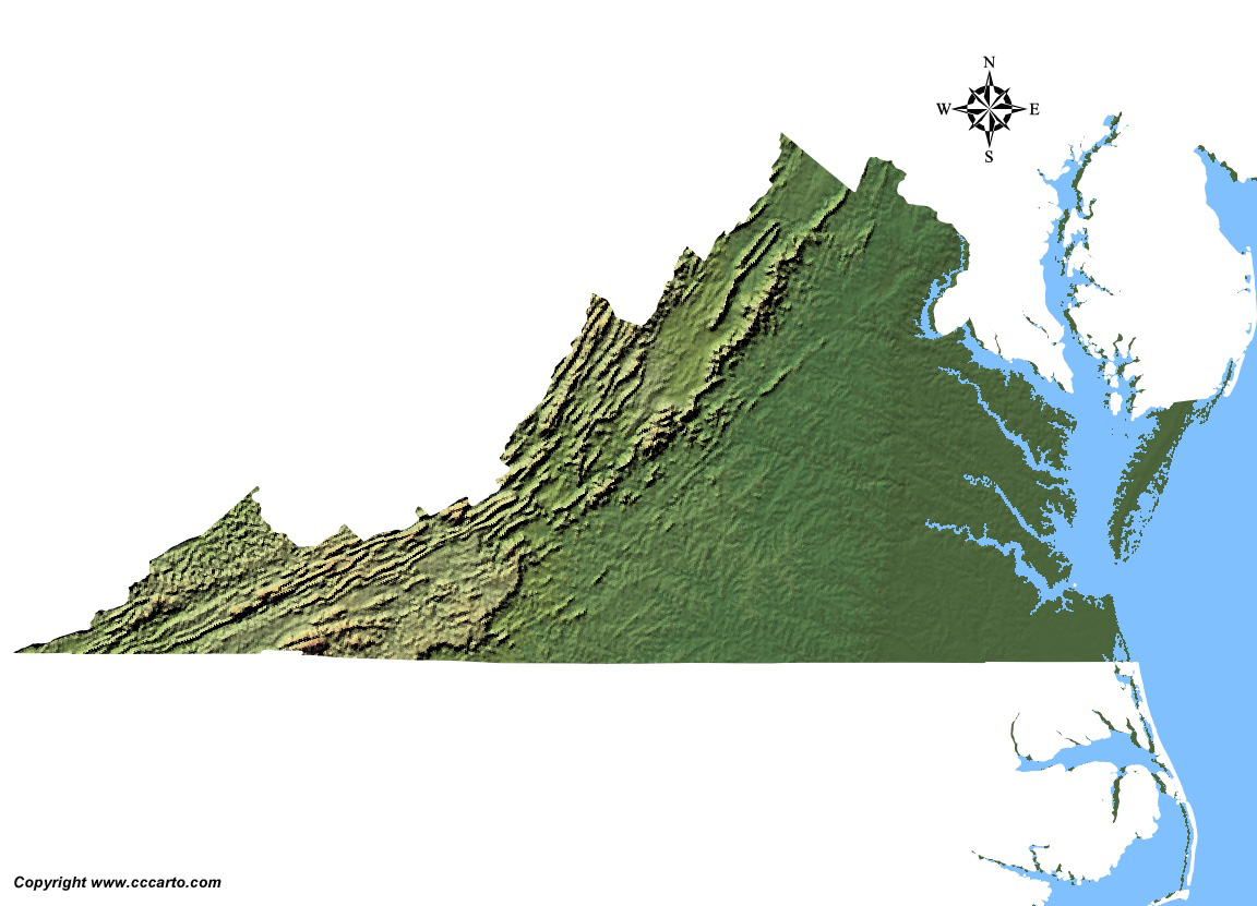
Virginia Topographic State Map | Shaded Relief
1. Blue Ridge Mountains
The Blue Ridge Mountains, part of the larger Appalachian Mountain range, run through the western part of Virginia. This area is known for its rolling peaks and rugged terrain. The Blue Ridge Parkway, a scenic drive through this region, offers breathtaking views of the lush forests and valleys below. The highest point in Virginia, Mount Rogers, is located in this region at an elevation of 5,729 feet.
2. Shenandoah Valley
The Shenandoah Valley lies between the Blue Ridge Mountains to the east and the Allegheny Mountains to the west. This fertile valley is one of the most picturesque regions in Virginia, known for its farmland, rivers, and the Shenandoah National Park. The valley is also home to the famous Skyline Drive, offering stunning views of the surrounding mountains and the valley below.
3. Piedmont
The Piedmont is a plateau region located between the Coastal Plain and the Blue Ridge Mountains. This region features gently rolling hills, forested areas, and many of Virginia’s historic sites, including plantations and battlefields. The terrain gradually rises as you move west toward the mountains, and the Piedmont is known for its significant role in agriculture and winemaking in the state.
4. Coastal Plain (Tidewater)
Virginia’s Coastal Plain, often referred to as the Tidewater region, is characterized by its flat, low-lying terrain. This area includes major cities like Norfolk and Virginia Beach and is home to several large rivers, estuaries, and wetlands. The Atlantic coastline and Chesapeake Bay define this region, which features sandy beaches and extensive maritime activities. The terrain here is mostly flat, with tidal influences shaping the landscape.
5. Allegheny Mountains
The Allegheny Mountains form part of the Appalachian Mountain range, located in the far western portion of Virginia. This area is known for its steep ridges, valleys, and dense forests. It is a popular destination for hiking, camping, and exploring, with trails such as the Appalachian Trail running through it. The region also experiences significant snowfall, making it suitable for winter activities like skiing and snowboarding.
6. Great Dismal Swamp
The Great Dismal Swamp, located in southeastern Virginia, is a vast, forested wetland that was once one of the largest swamps in the eastern United States. Today, it is part of the Great Dismal Swamp National Wildlife Refuge. The area is characterized by its marshy terrain, dense vegetation, and diverse wildlife, including black bears, migratory birds, and various amphibians. The swamp is a unique ecosystem that contrasts with the more mountainous regions of the state.
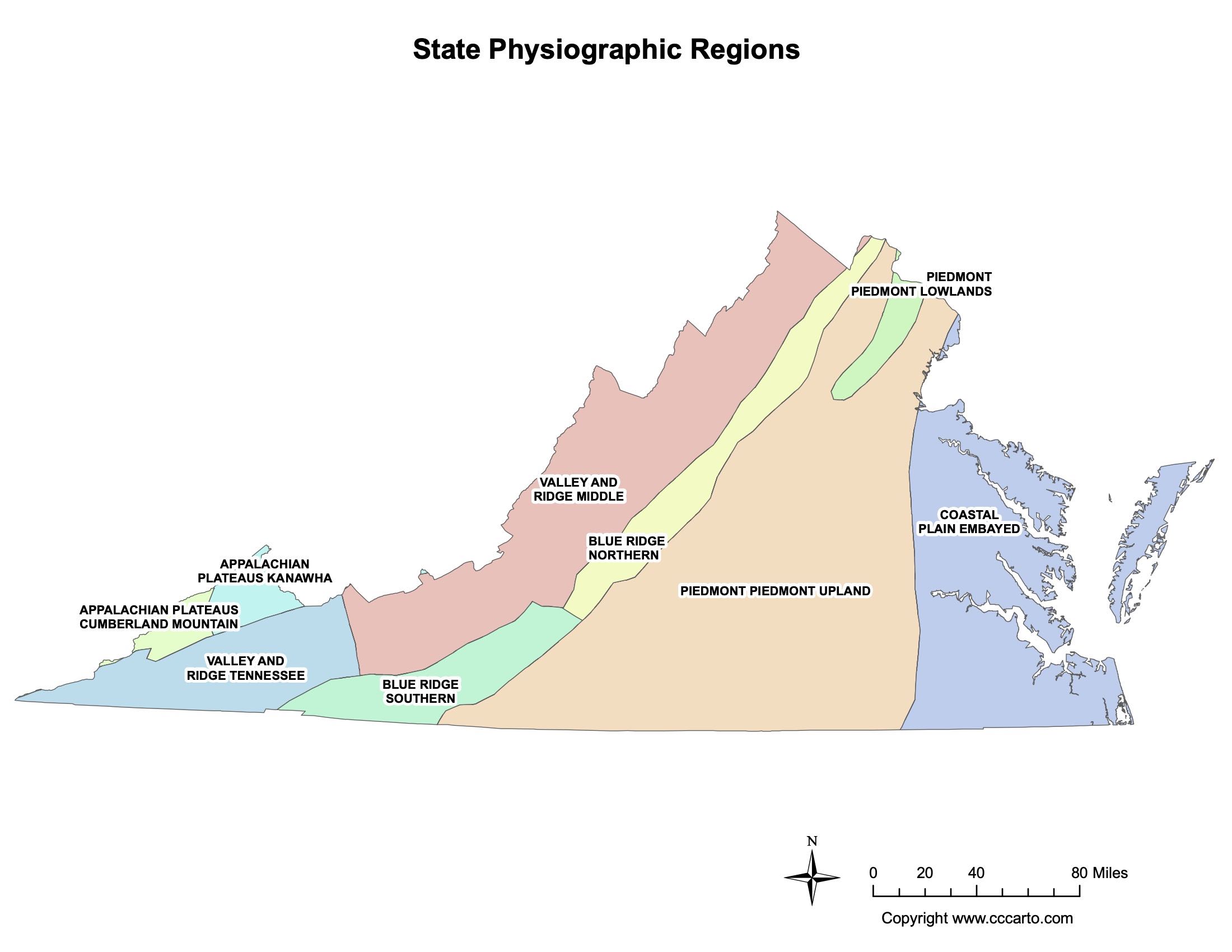
Virginia Physiographic Regions State Map
Appalachian Plateaus, Cumberland Mountain
The Appalachian Plateaus, specifically the Cumberland Mountain region, are located in the far southwestern corner of Virginia. This area is characterized by rugged, dissected plateaus with steep ridges and valleys. The Cumberland Mountain region is part of the Appalachian Coalfields, making it rich in coal deposits and historically important for mining. The terrain here is forested, with narrow, winding valleys, and small, rural communities. Elevations range from 2,000 to 4,000 feet, creating a dramatic landscape.
Appalachian Plateaus, Kanawha
The Kanawha section of the Appalachian Plateaus extends into Virginia from West Virginia. It is defined by flat-topped plateaus and deeply carved river valleys. The region is heavily forested, with a mix of deciduous and evergreen trees. Much of this area is drained by the New River, one of the oldest rivers in North America, which has cut deep gorges through the plateau. The region is sparsely populated and known for its natural beauty, as well as its historical significance in coal mining and timber industries.
Blue Ridge, Northern
The Northern Blue Ridge is part of the larger Blue Ridge Mountains that run through Virginia. This region features steep, rugged mountains with prominent peaks, such as Old Rag Mountain and the Peaks of Otter. The northern section is home to Shenandoah National Park and the famous Skyline Drive, offering scenic views of both the Shenandoah Valley and the Piedmont region. The Blue Ridge in this area is densely forested, with elevations reaching over 4,000 feet. The region’s geology is marked by ancient, weathered rock formations.
Blue Ridge, Southern
The Southern Blue Ridge extends into the southwestern part of Virginia and is known for its higher elevations and more dramatic terrain compared to the northern section. Mount Rogers, the highest peak in Virginia, is located here, reaching 5,729 feet. The Southern Blue Ridge features rugged mountains, deep valleys, and rolling hills. The region is popular for outdoor activities such as hiking, camping, and birdwatching. Its biodiversity is notable, with a variety of plant and animal species found in its forests and streams.
Coastal Plain, Embayed
The Coastal Plain, or Tidewater, region of Virginia is characterized by flat, low-lying terrain and is influenced by the Chesapeake Bay and Atlantic Ocean. The Embayed section of the Coastal Plain is marked by extensive estuaries, tidal wetlands, and river valleys that widen as they approach the coast. This area includes major cities like Norfolk and Virginia Beach and is home to important natural habitats such as the Great Dismal Swamp. The Coastal Plain is heavily influenced by its proximity to the sea, with sandy soils and frequent flooding.
Piedmont, Piedmont Lowlands
The Piedmont Lowlands form the eastern part of the Piedmont region of Virginia, where the terrain begins to level out as it approaches the Coastal Plain. This area features gently rolling hills and wide valleys with elevations ranging from 200 to 800 feet. The Piedmont Lowlands are known for their fertile soils, which support agriculture, including the state’s renowned wine industry. This region also includes historic towns and landmarks, playing a significant role in Virginia’s colonial and Civil War history.
Piedmont, Piedmont Upland
The Piedmont Upland region is located west of the Piedmont Lowlands and is characterized by higher elevations and more rugged terrain. The rolling hills become steeper as they approach the Blue Ridge Mountains, with elevations reaching up to 1,000 feet. This region is less densely populated and more rural, with forests, farms, and small towns dotting the landscape. The geology of the Piedmont Upland includes older, harder rocks that contribute to its more rugged topography compared to the lowlands.
Valley and Ridge, Middle
The Middle Valley and Ridge region is part of the larger Valley and Ridge Province, which stretches across western Virginia. This area is characterized by long, parallel ridges and valleys, formed by the folding and faulting of ancient rock layers. The Shenandoah Valley is one of the most prominent features in this region. The fertile valley floors are used for farming, while the forested ridges are popular for hiking and outdoor recreation. This region also has significant karst topography, including caves and sinkholes, formed by the dissolution of limestone.
Valley and Ridge, Tennessee
The Valley and Ridge, Tennessee section represents the southern extension of the Valley and Ridge region, stretching into the southwestern part of Virginia. Like the Middle section, this area is characterized by alternating ridges and valleys, but the terrain becomes more rugged and mountainous as it approaches the Tennessee border. This region is known for its scenic beauty, with forested ridges and fertile valleys. It is sparsely populated, with small towns and rural communities, and is a hub for outdoor activities like hiking, fishing, and camping.
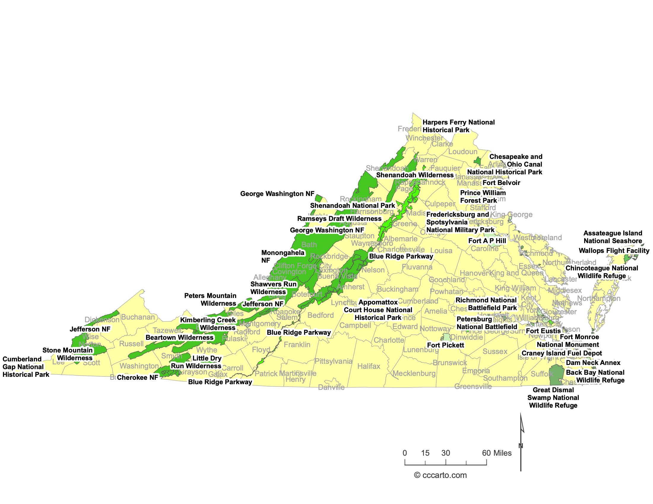
Virginia Federal Lands State Map | National Parks & Protected Areas
Historic Parks
Virginia is home to several historic parks that preserve important parts of U.S. history. Among them is **Colonial National Historical Park**, which links Jamestown, the first permanent English settlement, to Yorktown, where the American Revolution effectively ended. The park includes the Colonial Parkway, a scenic route connecting these two historic sites and Williamsburg.
Another significant site is **Appomattox Court House National Historical Park**, where General Robert E. Lee surrendered to Ulysses S. Grant, effectively ending the American Civil War. Visitors can explore restored buildings and learn about the events surrounding the Confederacy’s surrender.
Military Parks
**Fredericksburg and Spotsylvania National Military Park** is one of the most notable military parks in Virginia, preserving the battlefields of four major Civil War battles: Fredericksburg, Chancellorsville, Wilderness, and Spotsylvania Court House. These battles were among the bloodiest of the war, and the park includes monuments, visitor centers, and walking trails that interpret the events that took place there.
**Petersburg National Battlefield** is another significant military park, protecting the site of the Civil War's longest siege. The siege of Petersburg lasted nearly 10 months and ultimately led to the fall of Richmond, the Confederate capital.
National Park
**Shenandoah National Park** is Virginia's premier national park, located in the Blue Ridge Mountains. Famous for the **Skyline Drive**, the park offers stunning views, over 500 miles of hiking trails, waterfalls, and abundant wildlife. It is also part of the larger Appalachian Trail, making it a popular destination for hikers and nature enthusiasts. The park’s forests are home to black bears, deer, and numerous bird species.
National Forests
**George Washington National Forest** and **Jefferson National Forest** cover vast areas of western Virginia. These forests are known for their rugged mountain terrain, scenic vistas, and recreational opportunities, including hiking, camping, and fishing. They contain significant portions of the Appalachian Trail and feature diverse ecosystems, from hardwood forests to mountain streams.
**Croatan National Forest** also extends into parts of Virginia, offering similar landscapes of thick forests, streams, and wildlife habitat.
Wilderness Areas
**Ramsey’s Draft Wilderness** is a remote, rugged area within the George Washington National Forest. It features dense forests, rocky streams, and a rich variety of plant and animal life. The area is known for its old-growth hemlock trees and is a popular spot for backcountry hiking and camping.
**Shenandoah Wilderness** is part of Shenandoah National Park, preserving a pristine section of the Blue Ridge Mountains. The wilderness area offers solitude and the chance to experience unspoiled forests, wildlife, and trails that are less crowded than the more developed parts of the park.
Battlefields
**Manassas National Battlefield Park** preserves the site of two major Civil War battles, the First and Second Battles of Manassas (Bull Run). The park includes historic structures, monuments, and walking trails that bring visitors to key points on the battlefield.
**Richmond National Battlefield Park** is a collection of battle sites around Richmond, the capital of the Confederacy. The park preserves areas associated with the Seven Days Battles, the 1864 Overland Campaign, and the defenses of the city.
National Wildlife Refuges
**Great Dismal Swamp National Wildlife Refuge** is one of the largest wilderness areas in the eastern United States. This swampy habitat is home to black bears, bobcats, and over 200 species of birds. It is also historically significant, as the Great Dismal Swamp was once a refuge for Native Americans and runaway slaves.
**Eastern Shore of Virginia National Wildlife Refuge** protects critical habitat for migratory birds along the Atlantic Flyway. This refuge includes beaches, wetlands, and forests that support a wide variety of wildlife, particularly during the spring and fall migrations.
**Mason Neck National Wildlife Refuge** is located on the Potomac River and is a haven for bald eagles. The refuge protects wetlands and forested areas, providing vital habitat for the eagles and other wildlife species.
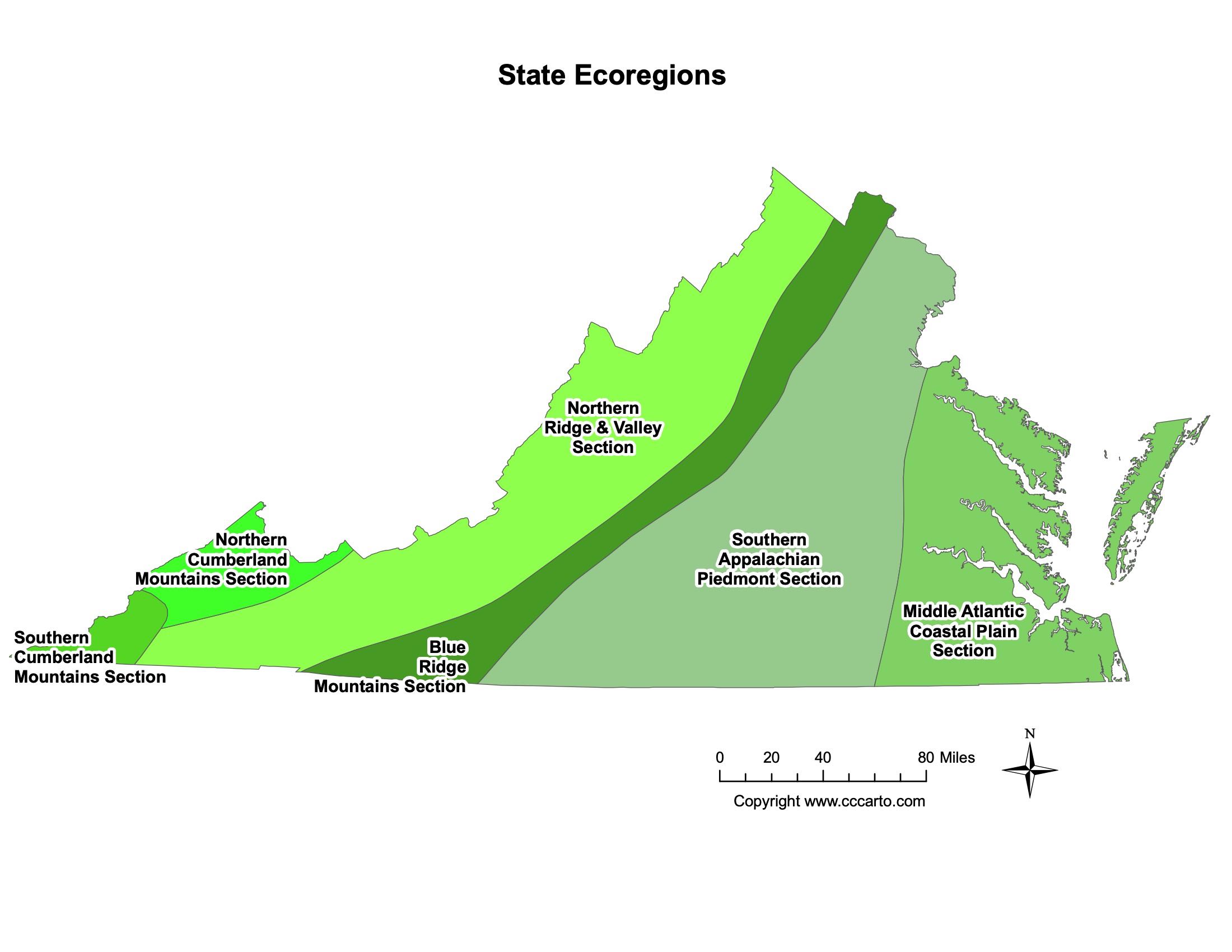
Virginia Ecoregions State Map | EPA Ecological Zones
Blue Ridge Mountains Section
The Blue Ridge Mountains section is part of the larger Appalachian Mountain chain and runs along the western part of Virginia. This ecoregion is known for its rugged terrain, high elevations, and rich biodiversity. The climate in this region is cooler and wetter than the surrounding areas, supporting a mix of hardwood and coniferous forests. It is home to species like black bears, white-tailed deer, and various birds and amphibians. The Blue Ridge Mountains also house important recreational areas like Shenandoah National Park and sections of the Appalachian Trail.
Middle Atlantic Coastal Plain Section
The Middle Atlantic Coastal Plain section covers the low-lying areas along Virginia's eastern coastline, including the Chesapeake Bay and parts of the Atlantic coast. This ecoregion features sandy soils, marshes, estuaries, and tidal wetlands. It is influenced by the proximity of saltwater and freshwater systems, which creates diverse habitats for species like waterfowl, fish, and amphibians. The Coastal Plain is also important for agriculture and urban development, with cities such as Norfolk and Virginia Beach located in this ecoregion. The region is prone to flooding and is heavily impacted by sea-level rise.
Northern Cumberland Mountains Section
The Northern Cumberland Mountains section is part of the Appalachian Plateau in the far southwestern part of Virginia. This ecoregion is characterized by steep, forested ridges and valleys, and it is one of the most rugged areas in the state. The forests here consist mainly of oak, hickory, and pine, providing habitat for a variety of wildlife including black bears, bobcats, and wild turkeys. The area has a history of coal mining, but much of the region remains forested and relatively undeveloped. Its remoteness and rough terrain make it ideal for outdoor activities like hiking and wildlife observation.
Northern Ridge & Valley Section
The Northern Ridge & Valley section is located in western Virginia, covering the northern part of the Appalachian Ridge and Valley Province. This ecoregion is defined by long, parallel ridges separated by fertile valleys, which are ideal for agriculture. The limestone-rich valleys have created karst landscapes, with caves, sinkholes, and underground streams. The region supports a variety of ecosystems, including mixed hardwood forests on the ridges and agricultural land in the valleys. It is home to many species of birds, mammals, and reptiles, and offers numerous recreational opportunities in areas like the George Washington National Forest.
Southern Appalachian Piedmont Section
The Southern Appalachian Piedmont section extends across the central part of Virginia and is characterized by rolling hills and low ridges. The soils here are more weathered and less fertile than those of the valleys, but the region is still used for agriculture, forestry, and urban development. The Piedmont is covered with a mix of hardwood and pine forests, and is home to species such as white-tailed deer, foxes, and songbirds. The region has experienced significant human impact, particularly around cities like Richmond and Charlottesville, but it retains large areas of natural habitat, especially in the foothills of the Blue Ridge Mountains.
Southern Cumberland Mountains Section
The Southern Cumberland Mountains section covers part of southwestern Virginia, extending into neighboring states. This ecoregion is part of the larger Appalachian Plateau and is characterized by rugged terrain with forested ridges, deep gorges, and narrow valleys. The area is known for its biological diversity, particularly in its hardwood forests, which support a variety of wildlife including salamanders, bats, and migratory birds. The region is also home to rare plant species that thrive in its unique habitats. The Southern Cumberland Mountains have been heavily affected by logging and mining, but efforts to conserve its natural areas have preserved much of its ecological integrity.