

Oregon State Maps | Complete Map Collection
Oregon State Maps: Detailed Maps for Counties, Cities, Federal Areas, Physiographic & Ecoregions
Welcome to our comprehensive collection of Oregon State Maps, meticulously curated to provide detailed, high-resolution visualizations of the state’s geography, political boundaries, and natural regions. These maps are designed for students, researchers, planners, and anyone seeking an in-depth visual reference.
- Counties and Cities: Clearly defined county boundaries and major cities for planning, education, and demographic reference.
- Federal Areas: National parks, forests, monuments, wildlife refuges, military installations, and other federally managed lands.
- Physiographic Regions: Major landforms and terrain features such as mountains, plains, valleys, plateaus, and coastal areas.
- Ecoregions: Ecological zones representing forests, grasslands, deserts, wetlands, and other biodiversity regions.
Map Profile
- Format: JPEG
- Color: RGB
- Resolution: ~72 DPI
- Typical image size: ~1300 × 1700 px
- Paper size: Letter (8.5 × 11 inches)
- Layouts: Portrait and Landscape
- File size: ~100–500 KB
Print tip: In your print dialog select Letter (8.5×11), choose Portrait or Landscape, and use Fit to Page (or Scale - to fit).
Oregon Counties Interesting Facts
Oregon’s 36 counties span Coast Range to high desert; Portland-area counties dominate population.
- Number of counties: 36 — List
- First & last established: Early 1843 counties; last created Deschutes (1916) — Newberry Atlas
- Highest & lowest county: Highest at Mt. Hood (Clackamas/Hood River); lowest sea level along the coast (e.g., Clatsop) — USGS
- Most & least populated: Most: Multnomah; Least: Wheeler
- Least & most developed (proxy): Most: Multnomah; Least: Wheeler
- Most geographically diverse: Deschutes County (Cascades, lava fields, rivers, high desert)
- Strangest-shaped county: Wallowa County (Hells Canyon prongs)
- State’s Biggest Commodity: Greenhouse & nursery. USDA NASS 2024
- Largest Private Employer: Providence Health & Services (statewide)
- Top 3 Non-English Languages: Spanish, Chinese, Vietnamese — DataUSA (ACS)
About CCCarto – Oregon State Maps Creator
CCCarto has been producing professional digital and GIS maps for large companies, government agencies, and educational institutions since 1988. With over 35 years of cartographic experience, our Oregon state maps are designed to the highest standards of accuracy, clarity, and usability.
Our map collection spans counties, cities, federal lands, ecoregions, physiographic regions, topographic relief, and more — giving students, researchers, educators, planners, and curious explorers the best Oregon state map resources available online. Every map is optimized for both screen viewing and letter-size printing.
Explore our full U.S. State Maps collection, or browse our Geology Maps, Travel Maps, and Energy Maps.
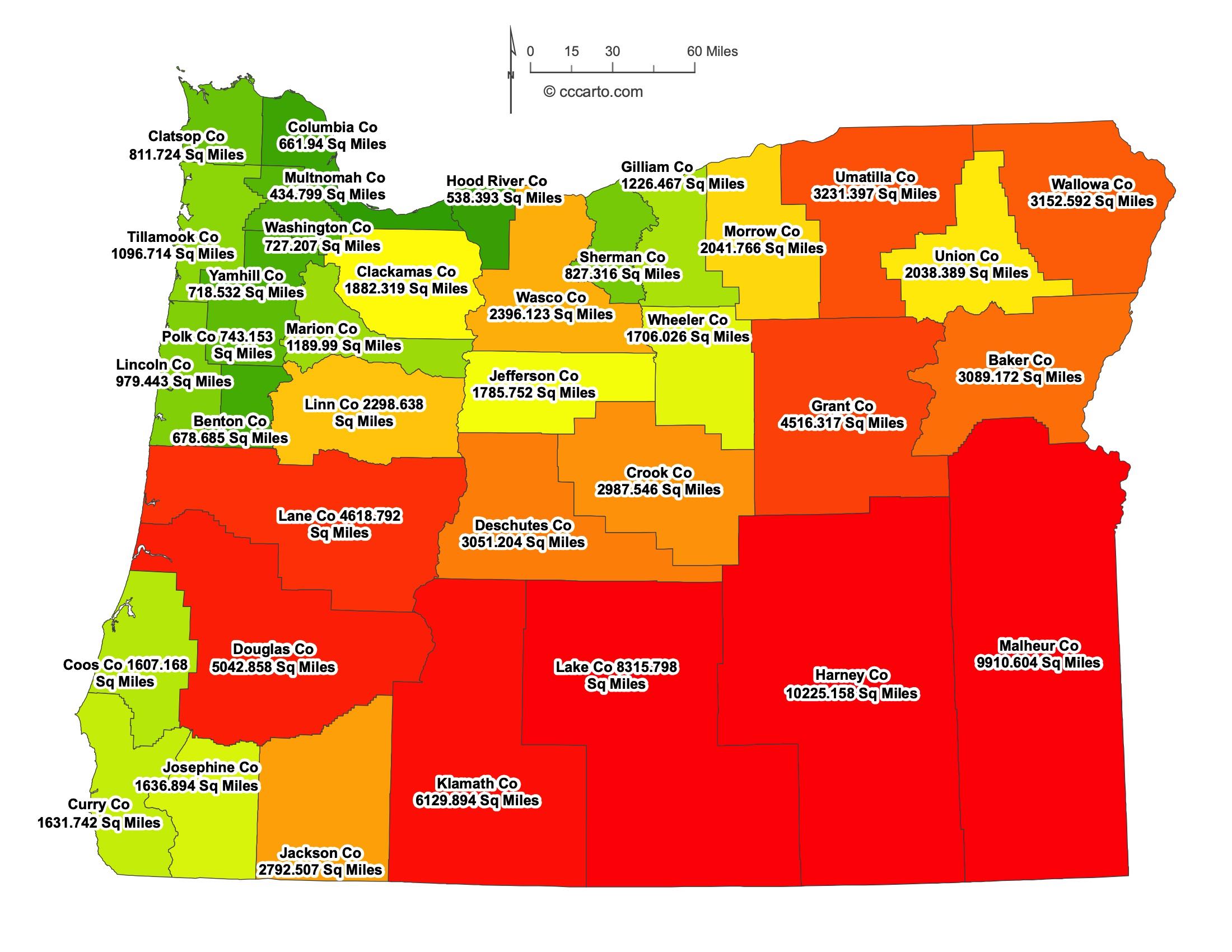
Oregon County Sizes State Map
Smallest County in Oregon State
Multnomah County: 435 sq miles
Largest County in Oregon State
Harney County: 10,225 sq miles
Mean and Median Area of Counties in Oregon State
Mean Area: 3,244 sq miles
Median Area: 1,722 sq miles

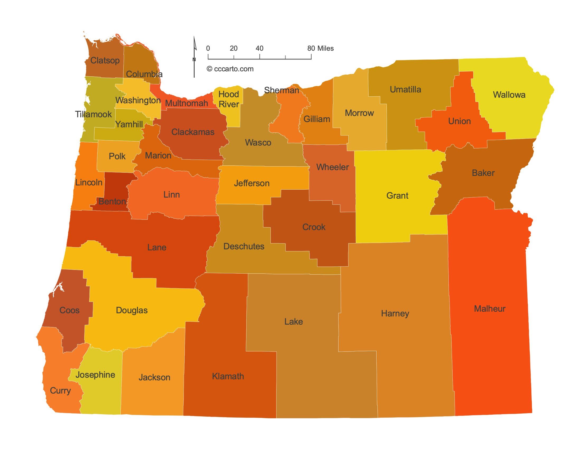
Major Cities of Oregon | Oregon Cities State Map
In Oregon State, major cities are often located near rivers or along historic transportation routes. Below are examples:
1. River Ports
Portland: The largest city in Oregon, Portland is located along the Columbia and Willamette Rivers. The rivers have historically supported the city's development as a shipping and economic hub.
Astoria: Located near the mouth of the Columbia River, Astoria is one of the oldest American settlements on the West Coast and has been a crucial river port for trade and shipping.
The Dalles: Situated along the Columbia River, The Dalles has historically served as a major river port and an important location for trade and agriculture in the region.
Coos Bay: This city is the largest deep-draft harbor along the Oregon Coast, making it a key port for shipping and timber industries.
Tillamook: Tillamook is located near the Tillamook Bay, an important harbor on the Oregon Coast. The city is known for its dairy industry, but also has a history of coastal and riverine trade.
2. Historic Routes
Eugene: Eugene is located along the I-5 corridor, a major transportation route through Oregon, supporting its growth in agriculture, trade, and education.
Salem: The capital of Oregon, Salem is located on the Willamette River and is an important city along historic transportation routes in the Willamette Valley.
Corvallis: Corvallis, home to Oregon State University, is also located on the Willamette River and has historically benefited from river access and its position in the agricultural heart of Oregon.
McMinnville: McMinnville is located in the Willamette Valley along historic roads and has grown into a center of agriculture and wine production.
Pendleton: Pendleton is located along the historic Oregon Trail and has long been a stopover for trade and travel across northeastern Oregon.
Ontario: Ontario is located near the Snake River along historic routes that connected western Idaho and eastern Oregon, making it a key agricultural and transportation hub.
3. Economic and Agricultural Centers
Bend: Located in central Oregon, Bend has developed into a major city and a hub for outdoor recreation and tourism. It also serves as a gateway to the Cascade Mountains.
Medford: Medford is located in southern Oregon's Rogue Valley along the I-5 corridor, historically benefiting from its position in agriculture and trade, particularly in fruit production.
Klamath Falls: Klamath Falls, situated near Klamath Lake, is a significant agricultural and logging center in southern Oregon. It also serves as a transportation hub for the region.
Lakeview: Located near the California border, Lakeview serves as a central point for agriculture, ranching, and forestry in southern Oregon. Its remote location makes it a key supply center for the region.
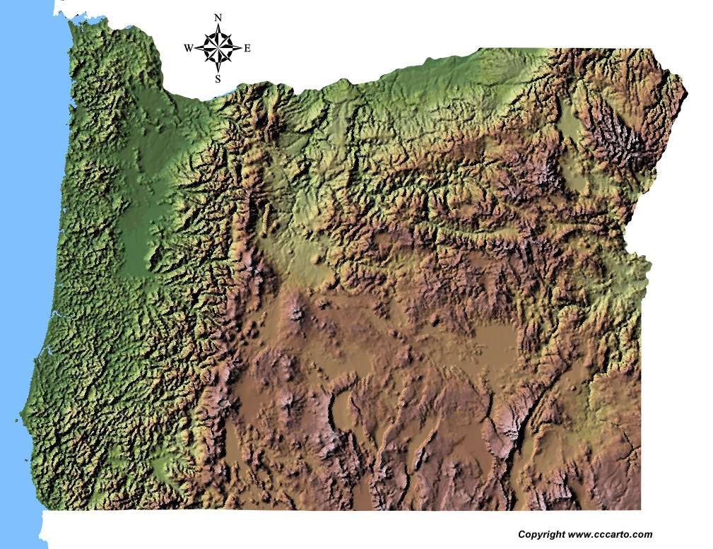
Oregon Topographic State Map | Shaded Relief
Oregon State features diverse terrains, from the coastal regions to mountain ranges and dry plateaus. The geography provides stunning landscapes for exploration and recreation. Below are several notable topographic areas:
1. Oregon Coast Range
The Oregon Coast Range runs parallel to the Pacific Ocean, featuring rugged mountains, dense forests, and dramatic cliffs along the coastline. This region is popular for hiking, scenic drives, and coastal recreation, offering views of rocky shores, beaches, and sea stacks.
2. Cascade Mountains
The Cascade Range stretches through central Oregon, with volcanic peaks such as Mount Hood, Mount Jefferson, and the Three Sisters. The region is known for its alpine environments, skiing, hiking, and stunning views of glacial lakes and meadows. The Cascades play a crucial role in Oregon's water supply and are a hub for outdoor activities.
3. Columbia River Gorge
The Columbia River Gorge, located along the Oregon-Washington border, is a deep canyon carved by the Columbia River. It features steep cliffs, dramatic waterfalls such as Multnomah Falls, and lush temperate rainforests. The gorge is a popular destination for hiking, windsurfing, and scenic drives.
4. High Desert and Lava Beds
Central and southeastern Oregon is characterized by arid landscapes, including high desert plateaus, sagebrush steppes, and volcanic features. The Newberry National Volcanic Monument, with its lava flows, cinder cones, and lava tubes, provides a fascinating glimpse into Oregon’s volcanic history.
5. Wallowa Mountains
Located in northeastern Oregon, the Wallowa Mountains are often called the "Alps of Oregon" due to their rugged beauty and towering peaks. This area features alpine lakes, steep valleys, and expansive wilderness, making it a prime location for backpacking, wildlife viewing, and mountaineering.
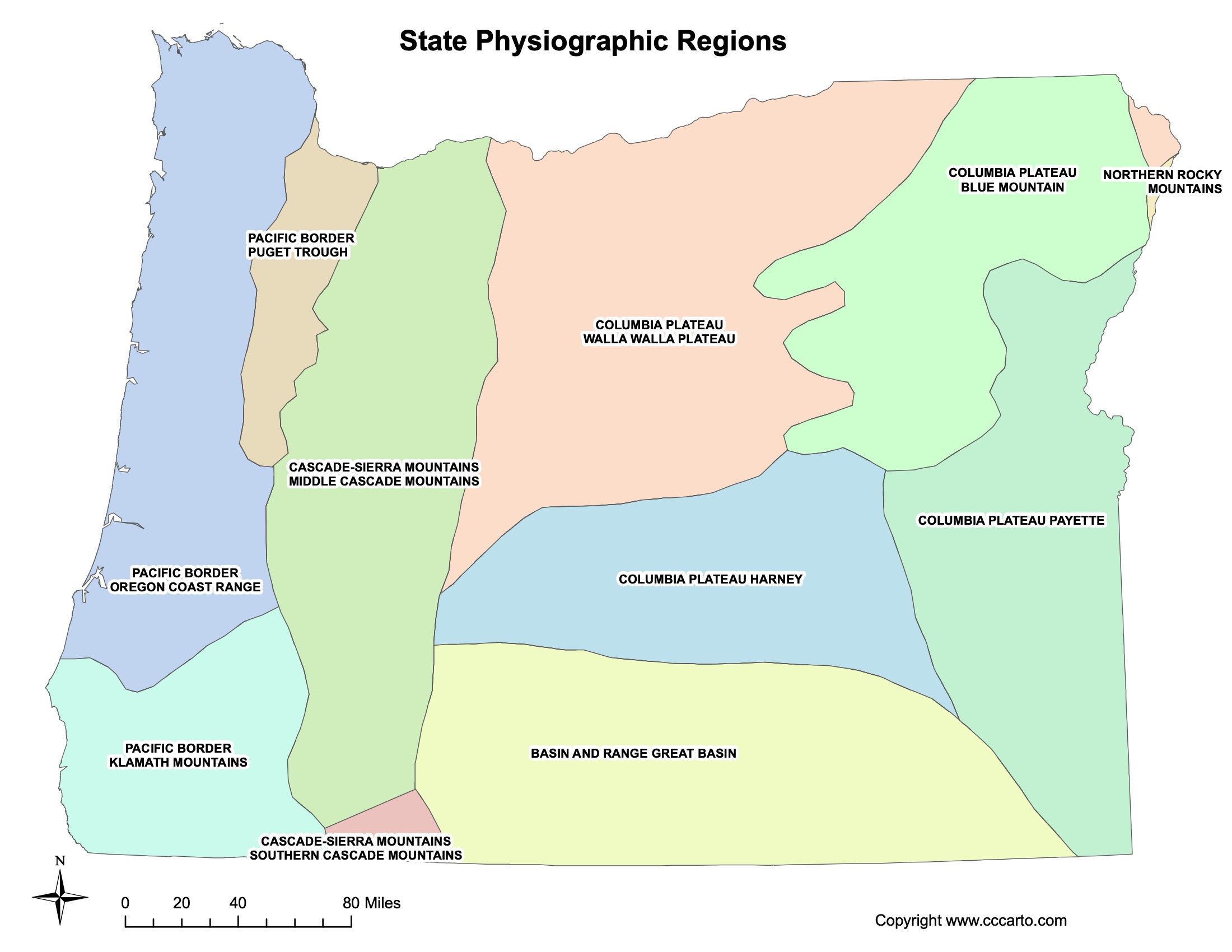
Oregon Physiographic Regions State Map
Pacific Border - Oregon Coast Range
The Oregon Coast Range forms part of the Pacific Border region, characterized by rugged mountains and dense forests. This area supports forestry, wildlife, and recreational activities.
Cascade-Sierra Mountains - Middle Cascade Mountains
The Cascade Mountains run through central Oregon, home to peaks such as Mount Hood. These volcanic mountains offer skiing, hiking, and diverse ecosystems, from forests to alpine meadows.
Columbia Plateau - Blue Mountains
The Blue Mountains in eastern Oregon rise from the Columbia Plateau, featuring rolling hills, canyons, and rich ecosystems. The semi-arid region is important for agriculture and wildlife.
Cascade-Sierra Mountains - Southern Cascade Mountains
The Southern Cascades in Oregon include volcanic peaks like Crater Lake, as well as high desert landscapes. The region offers diverse habitats ranging from alpine meadows to pine forests.
Columbia Plateau - Harney Basin
The Harney Basin, located in southeastern Oregon, is a flat, arid region dominated by sagebrush and grasslands. It is known for its wetlands and high desert ecology, supporting bird habitats and ranching.
Columbia Plateau - Payette
The Payette region in eastern Oregon is part of the broader Columbia Plateau. It features flat plains and arid landscapes that are used primarily for agriculture and livestock grazing.
Columbia Plateau - Walla Walla Plateau
The Walla Walla Plateau in northeastern Oregon is characterized by rolling hills and deep valleys. It is known for its agricultural productivity, particularly wheat farming and vineyards.
Northern Rocky Mountains
The Northern Rocky Mountains in northeastern Oregon are part of a rugged and mountainous region. The terrain is forested, with sharp peaks and deep valleys, supporting diverse wildlife and outdoor activities.
Pacific Border - Klamath Mountains
The Klamath Mountains in southwestern Oregon are known for their unique geology and biodiversity. The rugged terrain is home to old-growth forests, rare plant species, and a variety of wildlife. Timber production and outdoor recreation are significant in this region.
Pacific Border - Puget Trough
While primarily located in Washington, the southern end of the Puget Trough extends into northern Oregon. This lowland region is known for its fertile soils and is home to major population centers along the Willamette River.
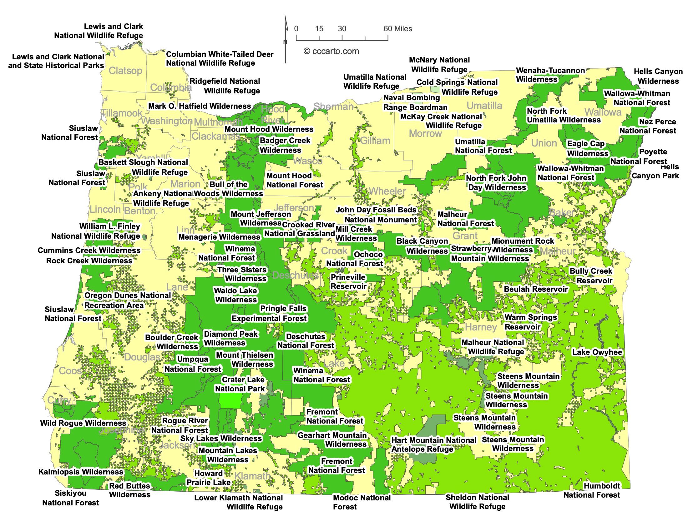
Oregon Federal Lands State Map | National Parks & Protected Areas
1. Crater Lake National Park
Crater Lake is one of the most popular destinations in Oregon. Its deep blue waters and volcanic origins make it a natural wonder visited by thousands each year.
2. Malheur National Wildlife Refuge
Located in southeastern Oregon, Malheur NWR is known for its diverse habitats, including wetlands, lakes, and high desert. It is a critical stopover for migratory birds and offers excellent opportunities for birdwatching and wildlife photography.
3. Klamath Basin National Wildlife Refuge Complex
This complex includes several refuges, such as the Lower Klamath and Tule Lake NWRs, located near the Oregon-California border. It provides important breeding and nesting grounds for waterfowl and is a hotspot for birdwatchers.
4. William L. Finley National Wildlife Refuge
Situated in the Willamette Valley, this NWR preserves habitats for wintering waterfowl and other wildlife. It features diverse landscapes, including wetlands, prairies, and oak savannas, offering scenic hiking and wildlife viewing opportunities.
5. Willamette National Forest
Willamette NF covers much of the western slopes of the Cascade Range and is home to towering peaks, rivers, and dense forests. Visitors can explore waterfalls, hiking trails, and areas for camping and fishing.
6. Deschutes National Forest
Located in central Oregon, Deschutes NF features scenic landscapes, including the Newberry National Volcanic Monument and extensive trails for hiking, mountain biking, and skiing. The forest also supports a variety of wildlife.
7. Rogue River-Siskiyou National Forest
This large national forest spans southwestern Oregon and parts of northern California. Known for its wild rivers, deep canyons, and diverse forests, it is popular for rafting, hiking, and fishing.
8. Umpqua National Forest
Located in southwestern Oregon, Umpqua NF is home to the beautiful North Umpqua River, waterfalls, and old-growth forests. The forest offers a wide range of recreational activities, including fishing, hiking, and hot springs.
9. Mount Hood Wilderness
This wilderness area surrounds Mount Hood, Oregon's highest peak. It offers spectacular views, challenging hikes, and pristine alpine environments. Mount Hood is a popular destination for skiing, climbing, and backpacking.
10. Three Sisters Wilderness
Located within the Deschutes and Willamette National Forests, this wilderness area features volcanic peaks, glaciers, and numerous lakes. It is a favorite for backcountry hiking, climbing, and camping.
11. Eagle Cap Wilderness
Found within the Wallowa Mountains in northeastern Oregon, the Eagle Cap Wilderness is known for its rugged beauty, high alpine lakes, and extensive trail system. It is popular for backpacking, horseback riding, and mountaineering.
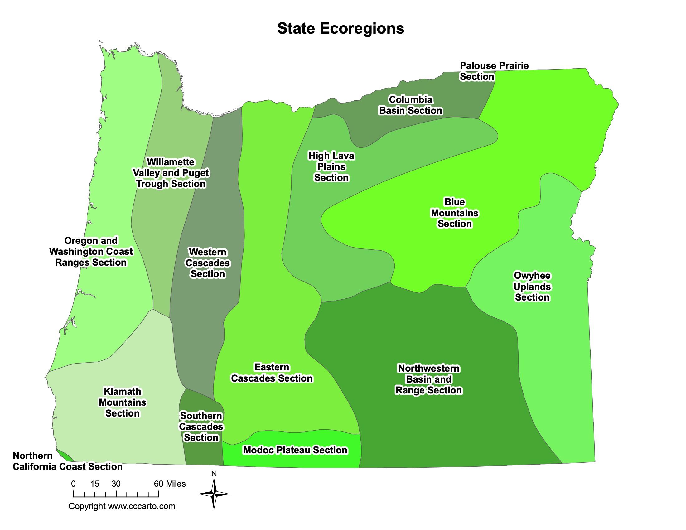
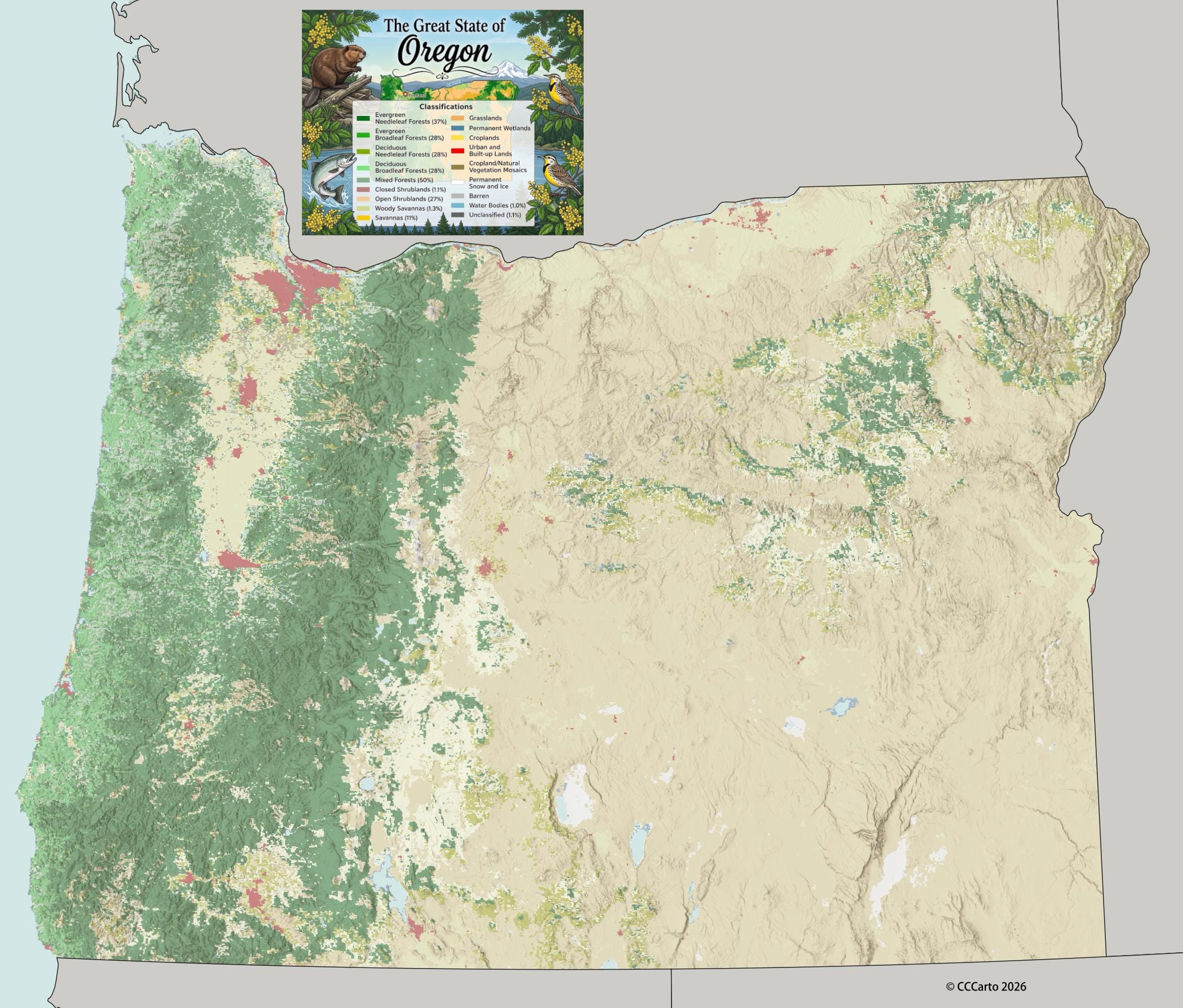
Oregon Ecoregions State Map | EPA Ecological Zones
Blue Mountains Section
The Blue Mountains ecoregion in Oregon features rugged terrain, forests, and rich biodiversity. It supports wildlife such as elk and bears, and is important for forestry and recreation.
Columbia Basin Section
The Columbia Basin in central Oregon is arid, with expansive sagebrush steppes and desert grasslands. It is vital for agriculture, using irrigation to support farming in the region.
Eastern Cascades Section
The Eastern Cascades ecoregion lies on the eastern slopes of the Cascade Range. This region transitions from wet forests to drier landscapes with pine forests and grasslands, supporting timber production, grazing, and outdoor recreation.
High Lava Plains Section
The High Lava Plains in central and southeastern Oregon consist of volcanic plateaus, basalt flows, and high desert landscapes. The region is sparsely vegetated but important for livestock grazing and geothermal energy.
Klamath Mountains Section
The Klamath Mountains in southwestern Oregon are characterized by diverse forests and steep terrain. The region is known for its biodiversity, supporting a variety of plant and animal species, and is important for timber production and recreation.
Modoc Plateau Section
The Modoc Plateau, extending into southeastern Oregon, is a region of volcanic highlands and desert basins. It features sagebrush and juniper woodlands and is used primarily for grazing and wildlife habitats.
Northern California Coast Section
This section of the Oregon coast is characterized by dense forests, rugged coastlines, and high rainfall. It supports a rich variety of plant and animal life, as well as important commercial fisheries and timber industries.
Northwestern Basin and Range Section
The Northwestern Basin and Range section in southeastern Oregon consists of arid basins, isolated mountain ranges, and desert landscapes. It is used for grazing and is home to many unique desert species.
Oregon and Washington Coast Ranges Section
The Oregon Coast Range is part of the Pacific Border region, characterized by rugged mountains, dense forests, and coastal ecosystems. This area supports forestry, wildlife, and recreation, including popular coastal trails and camping areas.
Owyhee Uplands Section
The Owyhee Uplands in southeastern Oregon consist of remote canyons, plateaus, and desert landscapes. The region is rich in archaeological sites and is popular for backcountry recreation and wildlife observation.
Palouse Prairie Section
The Palouse Prairie, located in the northeastern part of Oregon, features rolling hills and fertile soils. This region was historically a grassland prairie but has been largely converted to agriculture, particularly wheat farming.
Southern Cascades Section
The Southern Cascades section includes volcanic peaks, forests, and high desert plateaus. It is home to Crater Lake and offers opportunities for skiing, hiking, and exploring volcanic landscapes.
Western Cascades Section
The Western Cascades section lies on the wetter, western slopes of the Cascade Range. This area features dense temperate rainforests, rivers, and waterfalls, providing critical habitats for wildlife and offering popular outdoor recreation areas.
Willamette Valley and Puget Trough Section
The Willamette Valley and Puget Trough Section includes the fertile Willamette Valley, which is one of the most productive agricultural regions in Oregon. Known for its mild climate and rich soils, the valley supports a wide variety of crops, including fruits, vegetables, and vineyards. The region is also home to Oregon's largest cities, including Portland, Salem, and Eugene, and has been heavily developed for urban and industrial use.