

South Carolina State Maps | Complete Map Collection
South Carolina State Maps: Detailed Maps for Counties, Cities, Federal Areas, Physiographic & Ecoregions
Welcome to our comprehensive collection of South Carolina State Maps, meticulously curated to provide detailed, high-resolution visualizations of the state’s geography, political boundaries, and natural regions. These maps are designed for students, researchers, planners, and anyone seeking an in-depth visual reference.
- Counties and Cities: Clearly defined county boundaries and major cities for planning, education, and demographic reference.
- Federal Areas: National parks, forests, monuments, wildlife refuges, military installations, and other federally managed lands.
- Physiographic Regions: Major landforms and terrain features such as mountains, plains, valleys, plateaus, and coastal areas.
- Ecoregions: Ecological zones representing forests, grasslands, deserts, wetlands, and other biodiversity regions.
Map Profile
- Format: JPEG
- Color: RGB
- Resolution: ~72 DPI
- Typical image size: ~1300 × 1700 px
- Paper size: Letter (8.5 × 11 inches)
- Layouts: Portrait and Landscape
- File size: ~100–500 KB
Print tip: In your print dialog select Letter (8.5×11), choose Portrait or Landscape, and use Fit to Page (or Scale - to fit).

South Carolina Counties Interesting Facts
From mountain foothills to sea islands, South Carolina’s 46 counties reflect district-to-county reorganizations in the late 1700s and tweaks into the 1900s.
- Number of counties: 46. Newberry Atlas (state overview)
- First & last established: First county-level governments created in 1785; newest is Allendale (1919).
- Highest & lowest county: Highest point (Sassafras Mountain) in Pickens County; lowest at sea level in Charleston County. USGS
- Most & least populated: Most: Greenville County. Least: Allendale County.
- Least & most developed (proxy): Most developed: Greenville. Least developed: Allendale.
- Most geographically diverse: Oconee County (Blue Ridge, mountain lakes, waterfalls).
- Strangest-shaped county: Beaufort County — a fragmented archipelago of sea islands and marshes.

South Carolina County Sizes State Map
Smallest County in South Carolina State
McCormick County: 391 sq miles
Largest County in South Carolina State
Charleston County: 1358 sq miles(with separated islands and wetlands)
Mean and Median Area of Counties in South Carolina State
Mean Area: 622 sq miles
Median Area: 610 sq miles

Major Cities of South Carolina | South Carolina Cities State Map
In South Carolina, most major cities are located near rivers, coastal areas, or major transportation routes. Below are examples:
1. Coastal Ports
Charleston: A historic city on the coast, Charleston is one of South Carolina's largest ports and has played a central role in trade and commerce throughout its history.
Hilton Head Island: Located on the southern coast of South Carolina, Hilton Head Island is a major resort destination known for its beautiful beaches and golfing, drawing visitors from around the world.
Myrtle Beach: Myrtle Beach is one of South Carolina's most famous coastal cities, known for its long stretches of sandy beaches, boardwalk, and entertainment attractions, making it a prime tourist destination.
2. River Cities
Columbia: The state capital, Columbia, is located along the Congaree River. Its central location has historically made it an important hub for trade, politics, and transportation.
Aiken: Located near the Savannah River, Aiken is known for its equestrian culture and is a prominent location for horse training and competitions. It has long been a retreat for wealthy families.
Anderson: Known as the "Electric City" for its early adoption of electricity, Anderson is located near Lake Hartwell and has become a growing center for manufacturing and industry.
3. Historic Routes
Greenville: Located near the foothills of the Blue Ridge Mountains, Greenville has grown along historic transportation routes and is a center for industry and commerce in the region.
Spartanburg: Situated along historic railroads and transportation routes, Spartanburg has developed into a hub for manufacturing and industry, particularly in the automotive sector.

South Carolina Topographic State Map | Shaded Relief
South Carolina is known for its diverse terrains, shaped by its coastal plains, rivers, and mountainous regions. From the flat coastal lowlands to the rolling hills and mountains, South Carolina presents varied landforms.
1. Blue Ridge
Located in the northwest part of South Carolina, the Blue Ridge region includes part of the Appalachian Mountains. This area features rugged peaks, forests, and clear rivers. It's known for its scenic views, waterfalls, and recreational opportunities.
2. Coastal Plain
The Coastal Plain stretches along the eastern part of South Carolina and includes both flatlands and the Sea Islands. This region has fertile soils, estuaries, and wetlands. It's a hub for agriculture and forestry.
3. Piedmont
The Piedmont lies between the Blue Ridge and Coastal Plain, with rolling hills and red clay soils. This region is a mix of agriculture, industry, and residential areas and is home to Greenville and Spartanburg.
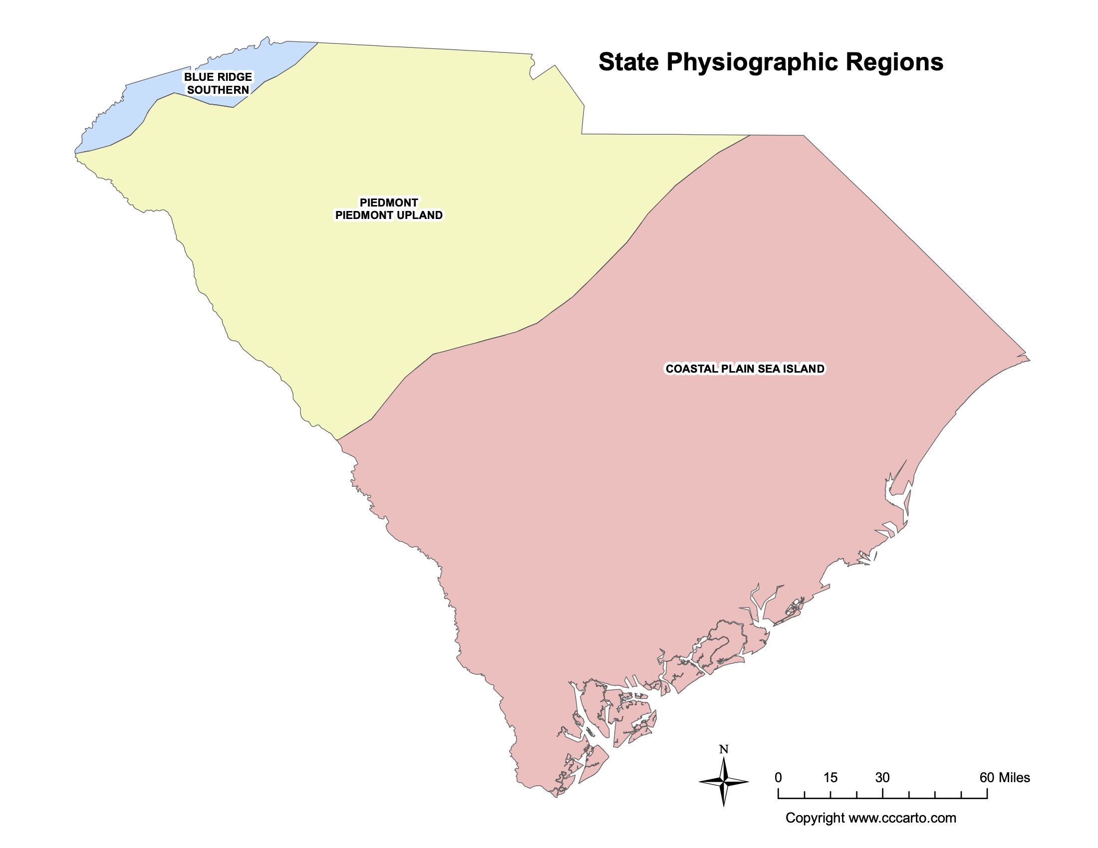
South Carolina Physiographic Regions State Map
Blue Ridge, Southern
The southern portion of the Blue Ridge covers the northwestern part of South Carolina. This area is known for its mountains, waterfalls, and hiking trails. The region is part of the Appalachian Mountains and offers scenic overlooks.
Coastal Plain, Sea Island
The Coastal Plain includes the flatlands stretching from the coast inland. This region also features the Sea Islands, which are known for their unique ecosystems, wetlands, and historical significance.
Piedmont, Piedmont Upland
The Piedmont Upland consists of gently rolling hills and is located between the Blue Ridge and the Coastal Plain. This area is important for agriculture, manufacturing, and urban development.

South Carolina Federal Lands State Map | National Parks & Protected Areas
1. Congaree National Park
Congaree National Park preserves the largest tract of old-growth bottomland hardwood forest in the United States. It is home to some of the tallest trees in the eastern U.S. and offers hiking, canoeing, and wildlife viewing opportunities.
2. Francis Marion National Forest
Located in the coastal plain, this national forest is known for its longleaf pine ecosystems and is home to a variety of wildlife, including red-cockaded woodpeckers. The forest provides recreational activities like hiking, birdwatching, and camping.
3. Fort Sumter National Monument(not shown on map)
Fort Sumter is a historic site where the first shots of the American Civil War were fired. The fort is located in Charleston Harbor and is accessible by boat. Visitors can explore the fort and learn about its role in American history.
4. Cowpens National Battlefield
Cowpens National Battlefield commemorates the site of a pivotal Revolutionary War victory. This battlefield offers visitors a chance to walk the grounds where American forces defeated the British in 1781. There is also a visitor center with exhibits about the battle.
5. Chattahoochee-Oconee National Forest
Though located primarily in Georgia, the Chattahoochee-Oconee National Forests extend into parts of South Carolina, offering opportunities for hiking, camping, fishing, and wildlife viewing. These forests contain hundreds of miles of trails and provide access to scenic views of the Blue Ridge Mountains.
6. Savannah National Wildlife Refuge
Straddling the border between South Carolina and Georgia, the Savannah National Wildlife Refuge offers vast wetlands and habitats that are perfect for birdwatching and wildlife viewing. The refuge provides trails, auto tours, and an observation deck for viewing its many bird species and alligators.
7. Carolina Sandhills National Wildlife Refuge
Carolina Sandhills National Wildlife Refuge is known for its rolling sandhills and diverse habitats that support species such as the red-cockaded woodpecker and gopher tortoise. Visitors can enjoy hiking, birdwatching, and photography in this ecologically rich area.
8. Kings Mountain National Military Park
Kings Mountain National Military Park preserves the site of a significant American victory during the Revolutionary War. Visitors can explore the battlefield, learn about the battle through interpretive exhibits, and hike the park’s scenic trails.
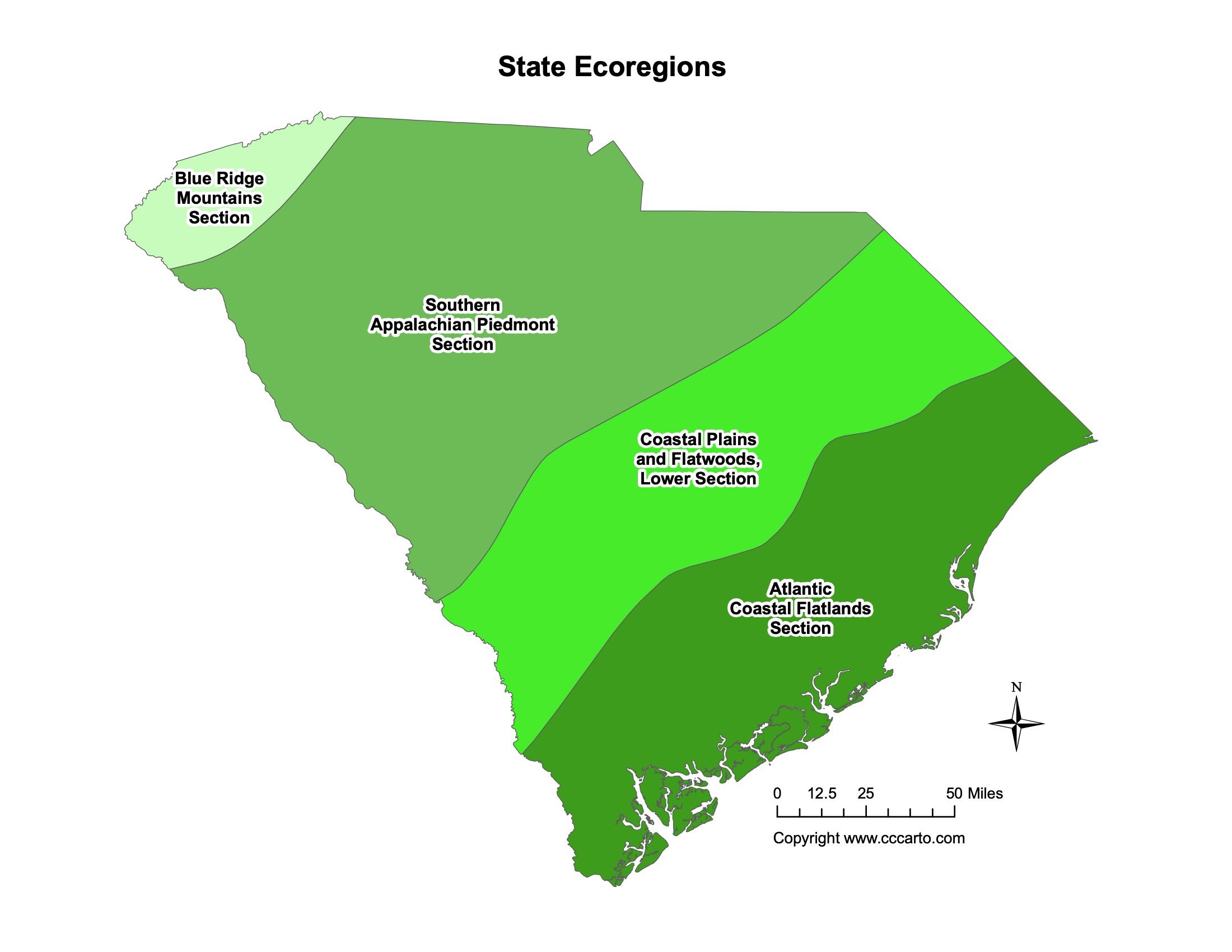
South Carolina Ecoregions State Map | EPA Ecological Zones
Atlantic Coastal Flatlands Section
The Atlantic Coastal Flatlands cover much of eastern South Carolina. This region is characterized by flat topography, wetlands, and marshes. It supports a rich diversity of wildlife and is important for agriculture, especially rice and indigo in the past.
Blue Ridge Mountains Section
This ecoregion covers the mountainous areas of northwest South Carolina. The Blue Ridge Mountains are rich in biodiversity, with forests, streams, and wildlife habitats that support a variety of species.
Coastal Plains and Flatwoods, Lower
The Lower Coastal Plains and Flatwoods extend from the coast into the interior and include swamps, marshes, and pine forests. This area is known for its timber and forest products, as well as its biodiversity.
About CCCarto – South Carolina State Maps Creator
CCCarto has been producing professional digital and GIS maps for large companies, government agencies, and educational institutions since 1988. With over 35 years of cartographic experience, our South Carolina state maps are designed to the highest standards of accuracy, clarity, and usability.
Our map collection spans counties, cities, federal lands, ecoregions, physiographic regions, topographic relief, and more — giving students, researchers, educators, planners, and curious explorers the best South Carolina state map resources available online. Every map is optimized for both screen viewing and letter-size printing.
Explore our full U.S. State Maps collection, or browse our Geology Maps, Travel Maps, and Energy Maps.