

New Jersey State Maps | Complete Map Collection
New Jersey State Maps: Detailed Maps for Counties, Cities, Federal Areas, Physiographic & Ecoregions
Welcome to our comprehensive collection of New Jersey State Maps, meticulously curated to provide detailed, high-resolution visualizations of the state’s geography, political boundaries, and natural regions. These maps are designed for students, researchers, planners, and anyone seeking an in-depth visual reference.
- Counties and Cities: Clearly defined county boundaries and major cities for planning, education, and demographic reference.
- Federal Areas: National parks, forests, monuments, wildlife refuges, military installations, and other federally managed lands.
- Physiographic Regions: Major landforms and terrain features such as mountains, plains, valleys, plateaus, and coastal areas.
- Ecoregions: Ecological zones representing forests, grasslands, deserts, wetlands, and other biodiversity regions.
Map Profile
- Format: JPEG
- Color: RGB
- Resolution: ~72 DPI
- Typical image size: ~1300 × 1700 px
- Paper size: Letter (8.5 × 11 inches)
- Layouts: Portrait and Landscape
- File size: ~100–500 KB
Print tip: In your print dialog select Letter (8.5×11), choose Portrait or Landscape, and use Fit to Page (or Scale - to fit).
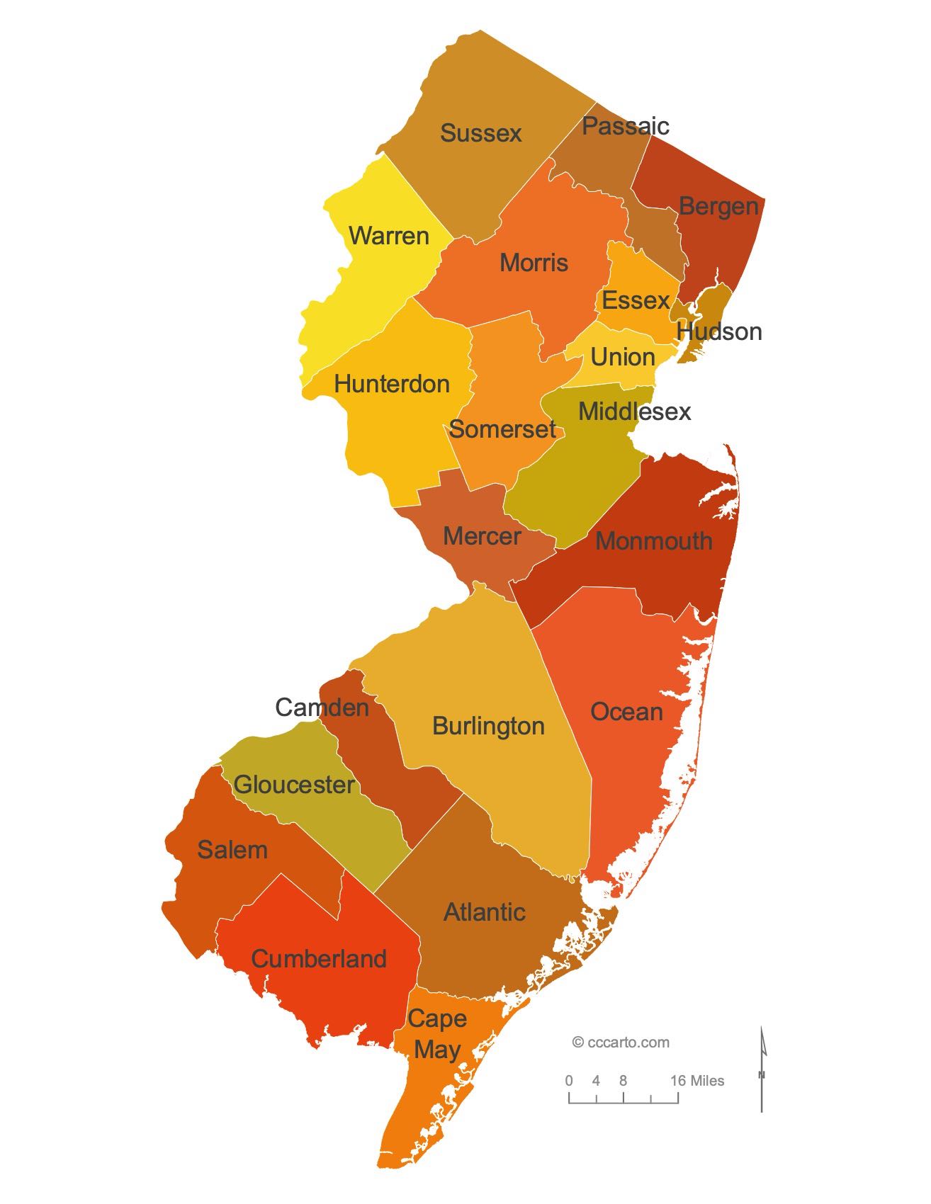
New Jersey Counties Interesting Facts
New Jersey’s 21 counties pack dense metros and coastal resort belts into a small footprint.
- Number of counties: 21 — NJ.gov
- First & last established: First four in 1683; newest is Union (1857) — summaries & Newberry
- Highest & lowest county: Highest High Point in Sussex County; lowest sea level along coastal counties (e.g., Cape May) — USGS
- Most & least populated: Most: Bergen; Least: Salem
- Least & most developed: Most: Hudson / Bergen; Least: Salem
- Most geographically diverse: Sussex County (Kittatinny ridge, lakes, Delaware Water Gap)
- Strangest-shaped county: Cape May County — a tapered peninsula with barrier islands
- State’s Biggest Commodity: Nursery/greenhouse/floriculture & sod. NJ Dept. of Agriculture (2024)
- Largest Private Employer: Amazon (NJ)
- Top 3 Non-English Languages: Spanish, Chinese, Gujarati — DataUSA (ACS)
About CCCarto – New Jersey State Maps Creator
CCCarto has been producing professional digital and GIS maps for large companies, government agencies, and educational institutions since 1988. With over 35 years of cartographic experience, our New Jersey state maps are designed to the highest standards of accuracy, clarity, and usability.
Our map collection spans counties, cities, federal lands, ecoregions, physiographic regions, topographic relief, and more — giving students, researchers, educators, planners, and curious explorers the best New Jersey state map resources available online. Every map is optimized for both screen viewing and letter-size printing.
Explore our full U.S. State Maps collection, or browse our Geology Maps, Travel Maps, and Energy Maps.
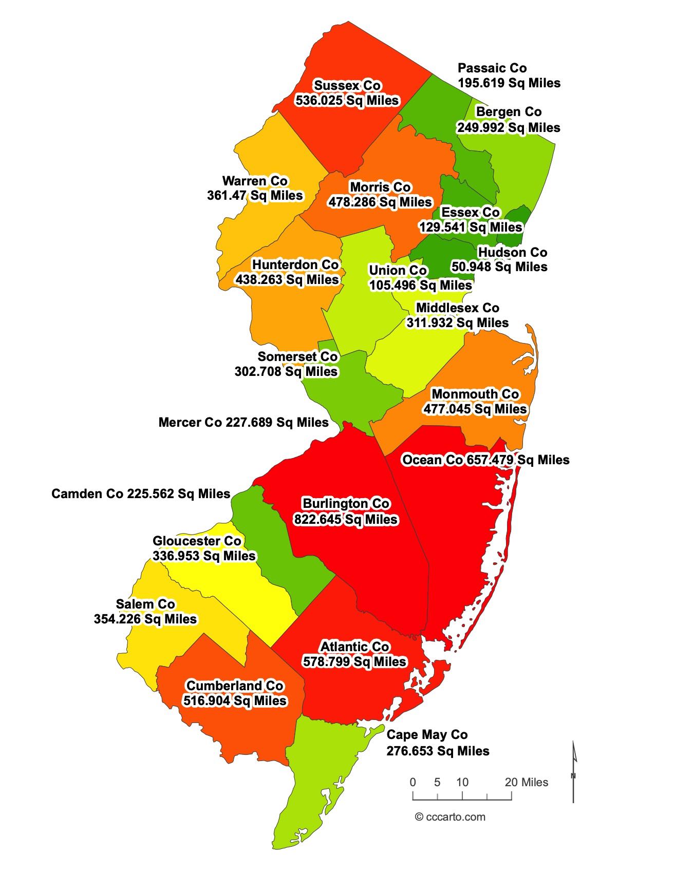
New Jersey County Sizes State Map
Smallest County in New Jersey State
Hudson County: 51 sq miles
Largest County in New Jersey State
Burlington County: 822 sq miles
Mean and Median Area of Counties in New Jersey State
Mean Area: 343.95 sq miles
Median Area: 228.0 sq miles
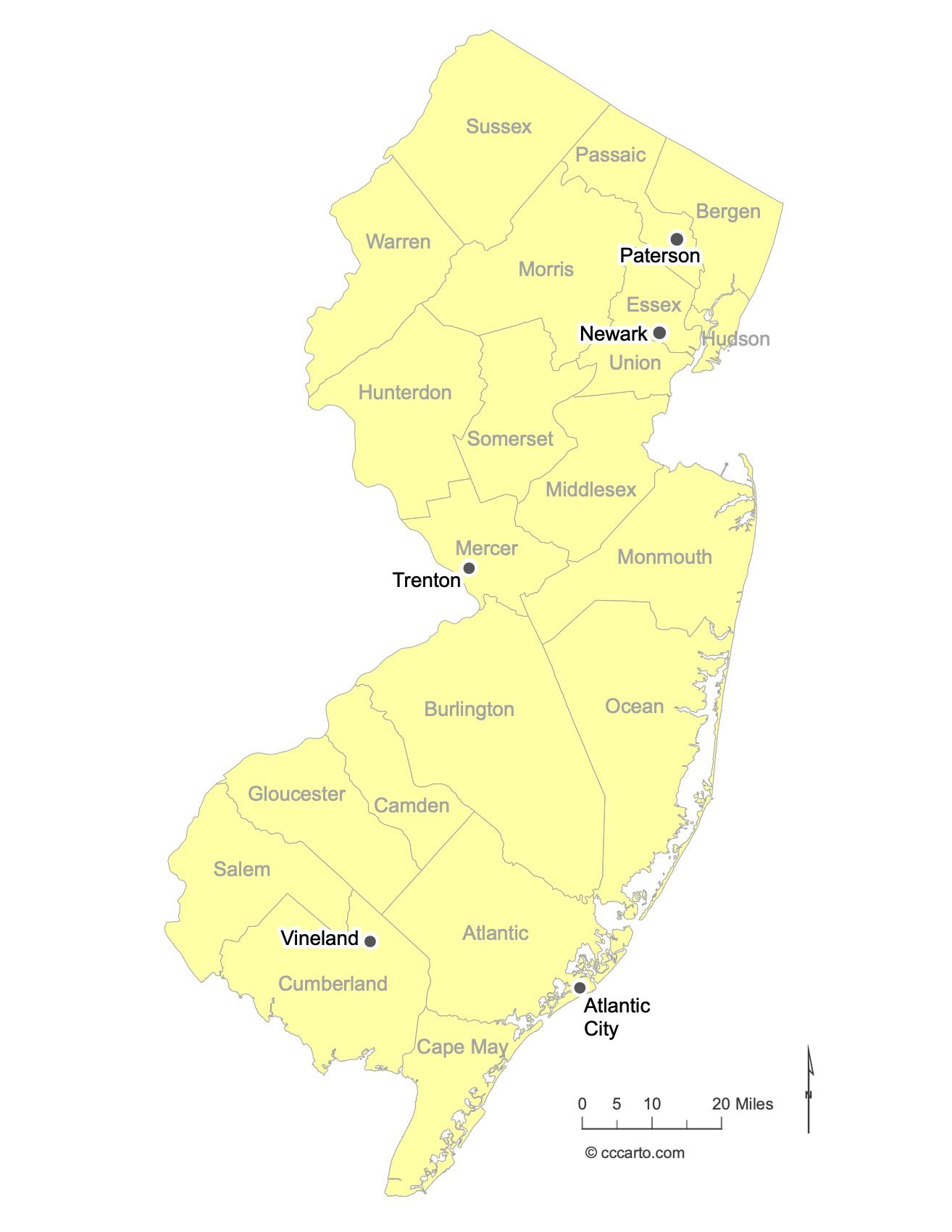
Major Cities of New Jersey | New Jersey Cities State Map
New Jersey is home to several major cities, each with its own unique characteristics and geographic location. Below are some of the key cities in the state:
- Newark: The largest city in New Jersey, Newark is located in the northeastern part of the state, near the Passaic River. It serves as a major hub for transportation, commerce, and culture, and is home to Newark Liberty International Airport.
- Trenton: Located in the western part of the state, Trenton is the capital city of New Jersey. It sits along the Delaware River and has significant historical importance, particularly related to the American Revolutionary War.
- Paterson: Situated in the northeastern part of New Jersey, Paterson is known for its industrial history and Great Falls, one of the largest waterfalls in the eastern United States. Paterson played a vital role in the silk industry, earning it the nickname “Silk City.”
- Atlantic City: A coastal city located in the southeastern part of the state along the Atlantic Ocean, Atlantic City is famous for its boardwalk, beaches, and casinos. It has been a popular tourist destination for over a century.
- Vineland: Located in the southern part of New Jersey, Vineland is known for its agricultural roots. It has a more rural setting compared to other major cities in the state and is a center for farming and food production.

New Jersey Topographic State Map | Shaded Relief
New Jersey, though one of the smaller states, is home to diverse topography. Here are some of its key features:
- Appalachian Mountains: The northwest region of New Jersey is part of the Appalachian Mountain range, with the highest point being High Point at 1,803 feet above sea level. The Appalachian Trail also crosses through this region, offering rugged, scenic terrain.
- Pinelands: Covering about 22% of New Jersey's land area, the Pinelands is a vast forested area characterized by sandy soils and pitch pine trees. It is a designated UNESCO Biosphere Reserve.
- Piedmont Plateau: Central New Jersey lies within the Piedmont Plateau, featuring gently rolling hills and fertile plains. This area is a key agricultural zone in the state.
- Atlantic Coastal Plain: The majority of New Jersey is part of the Atlantic Coastal Plain, with low-lying areas near the coast. This region includes barrier islands, salt marshes, and sandy beaches.
- Delaware Water Gap: A scenic area formed by the Delaware River cutting through the Kittatinny Ridge, creating a water gap that is popular for hiking, canoeing, and scenic vistas.
- Highlands: The Highlands region in northern New Jersey is marked by rolling hills, forests, and valleys, and is known for its lakes and reservoirs, which provide water to much of the state.

New Jersey Physiographic Regions State Map
Coastal Plain, Embayed
The Coastal Plain of New Jersey is characterized by flat, low-lying terrain extending inland from the Atlantic coast. This region includes significant wetlands, tidal areas, and sandy soils that are ideal for agriculture and coastal ecosystems.
New England, New England Upland
The New England Upland region of New Jersey consists of rolling hills and uplands formed from ancient metamorphic rocks. This area includes diverse forested habitats and is known for its rich historical and cultural significance.
Piedmont, Piedmont Lowlands
The Piedmont Lowlands of New Jersey feature gently rolling hills and valleys with sedimentary rock formations. This region is home to numerous rivers and streams and includes many of the state's agricultural and urban centers.
Valley And Ridge, Middle
The Valley and Ridge region of New Jersey is characterized by alternating ridges and valleys formed by folded and faulted sedimentary rocks. This area supports agriculture and forested habitats and is known for its scenic beauty.
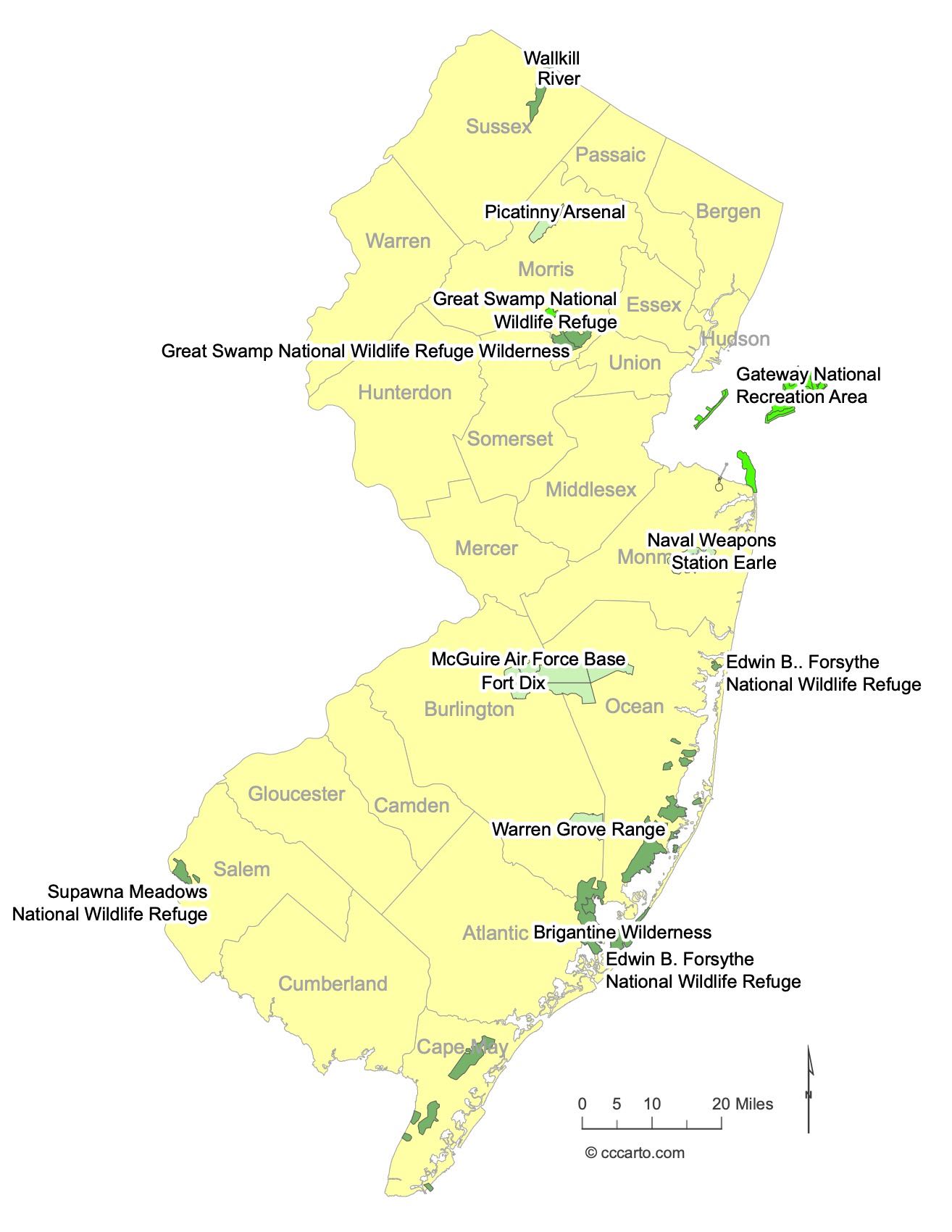
Notable Federal Lands in New Jersey: Largest and Most Fascinating Destinations
New Jersey is home to a variety of federally protected lands that offer scenic beauty, historical significance, and recreational opportunities. Below are some of the Notable Federal Lands: Some of the Largest and Most Fascinating Destinations in the state:
- Edwin B. Forsythe National Wildlife Refuge: Located along the Atlantic Flyway, this 47,000-acre refuge is a critical habitat for migratory birds, including shorebirds and waterfowl. It’s a popular spot for bird watching and photography.
- Supawna Meadows National Wildlife Refuge: Situated along the Delaware River in southern New Jersey, this 3,000-acre refuge preserves tidal salt marshes, fields, and forests. It provides vital habitat for migratory birds and other wildlife species.
- Gateway National Recreation Area (Sandy Hook Unit): Part of the larger Gateway NRA, Sandy Hook offers miles of ocean beaches, historic military installations, and opportunities for biking, hiking, and bird watching. The area also includes the Sandy Hook Lighthouse, the oldest working lighthouse in the United States.
- Warren Grove Range: Managed by the U.S. Air National Guard, this area is a military training site located in the Pinelands National Reserve. While it's primarily used for military exercises, it is also part of the unique Pinelands ecosystem and helps protect natural habitats.
- Great Swamp National Wildlife Refuge: Encompassing 7,800 acres in northern New Jersey, this refuge protects wetlands and a variety of wildlife species. Visitors can enjoy trails, bird watching, and educational programs.
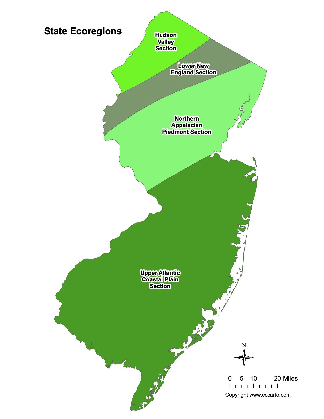
New Jersey Ecoregions State Map | EPA Ecological Zones
Hudson Valley Section
The Hudson Valley Section in New Jersey includes parts of the river valleys and surrounding areas that are vital for agriculture, urban settlements, and biodiversity. This region features a mix of hardwood forests, wetlands, and agricultural land.
Lower New England Section
The Lower New England Section covers areas with rolling hills and mixed deciduous forests. This ecoregion supports a diverse range of plant and animal life, and its forests are known for vibrant autumn foliage.
Northern Appalachian Piedmont Section
The Northern Appalachian Piedmont in New Jersey is characterized by rolling terrain and forested hills. This region is ecologically significant due to its mix of woodland, meadows, and streams that provide habitats for diverse wildlife species.
Upper Atlantic Coastal Plain Section
The Upper Atlantic Coastal Plain Section encompasses flat, sandy terrain that extends inland from the coast. This region includes coastal forests, wetlands, and marshes that are crucial for bird migration and other wildlife.