

Nebraska State Maps | Complete Map Collection
Nebraska State Maps: Detailed Maps for Counties, Cities, Federal Areas, Physiographic & Ecoregions
Welcome to our comprehensive collection of Nebraska State Maps, meticulously curated to provide detailed, high-resolution visualizations of the state’s geography, political boundaries, and natural regions. These maps are designed for students, researchers, planners, and anyone seeking an in-depth visual reference.
- Counties and Cities: Clearly defined county boundaries and major cities for planning, education, and demographic reference.
- Federal Areas: National parks, forests, monuments, wildlife refuges, military installations, and other federally managed lands.
- Physiographic Regions: Major landforms and terrain features such as mountains, plains, valleys, plateaus, and coastal areas.
- Ecoregions: Ecological zones representing forests, grasslands, deserts, wetlands, and other biodiversity regions.
Map Profile
- Format: JPEG
- Color: RGB
- Resolution: ~72 DPI
- Typical image size: ~1300 × 1700 px
- Paper size: Letter (8.5 × 11 inches)
- Layouts: Portrait and Landscape
- File size: ~100–500 KB
Print tip: In your print dialog select Letter (8.5×11), choose Portrait or Landscape, and use Fit to Page (or Scale - to fit).

Nebraska Counties Interesting Facts
Nebraska’s 93 counties range from urban (Douglas/Lancaster) to vast Sandhills (Cherry).
- Number of counties: 93 — List
- First & last established: 1850s+; last created Arthur (1913) — Newberry Atlas
- Highest & lowest county: Highest at Panorama Point (Kimball); lowest Missouri R. (Richardson) — USGS
- Most & least populated: Most: Douglas; Least: Arthur
- Least & most developed (proxy): Most: Douglas; Least: Arthur (links above)
- Most geographically diverse: Cherry County (Sandhills, rivers, lakes)
- Strangest-shaped county: Thurston County (reservation boundaries create irregular outline)
- State’s Biggest Commodity: Cattle & calves. USDA ERS
- Largest Private Employer: Health system cluster (e.g., CHI Health) leads private headcount statewide/regional
- Top 3 Non-English Languages: Spanish, Vietnamese, Chinese — DataUSA
About CCCarto – Nebraska State Maps Creator
CCCarto has been producing professional digital and GIS maps for large companies, government agencies, and educational institutions since 1988. With over 35 years of cartographic experience, our Nebraska state maps are designed to the highest standards of accuracy, clarity, and usability.
Our map collection spans counties, cities, federal lands, ecoregions, physiographic regions, topographic relief, and more — giving students, researchers, educators, planners, and curious explorers the best Nebraska state map resources available online. Every map is optimized for both screen viewing and letter-size printing.
Explore our full U.S. State Maps collection, or browse our Geology Maps, Travel Maps, and Energy Maps.

Nebraska County Sizes State Map
Smallest County in Nebraska State
Sarpy County: 247 sq miles
Largest County in Nebraska State
Cherry County: 5978 sq miles
Mean and Median Area of Counties in Nebraska State
Mean Area: 576 sq miles
Median Area: 573 sq miles
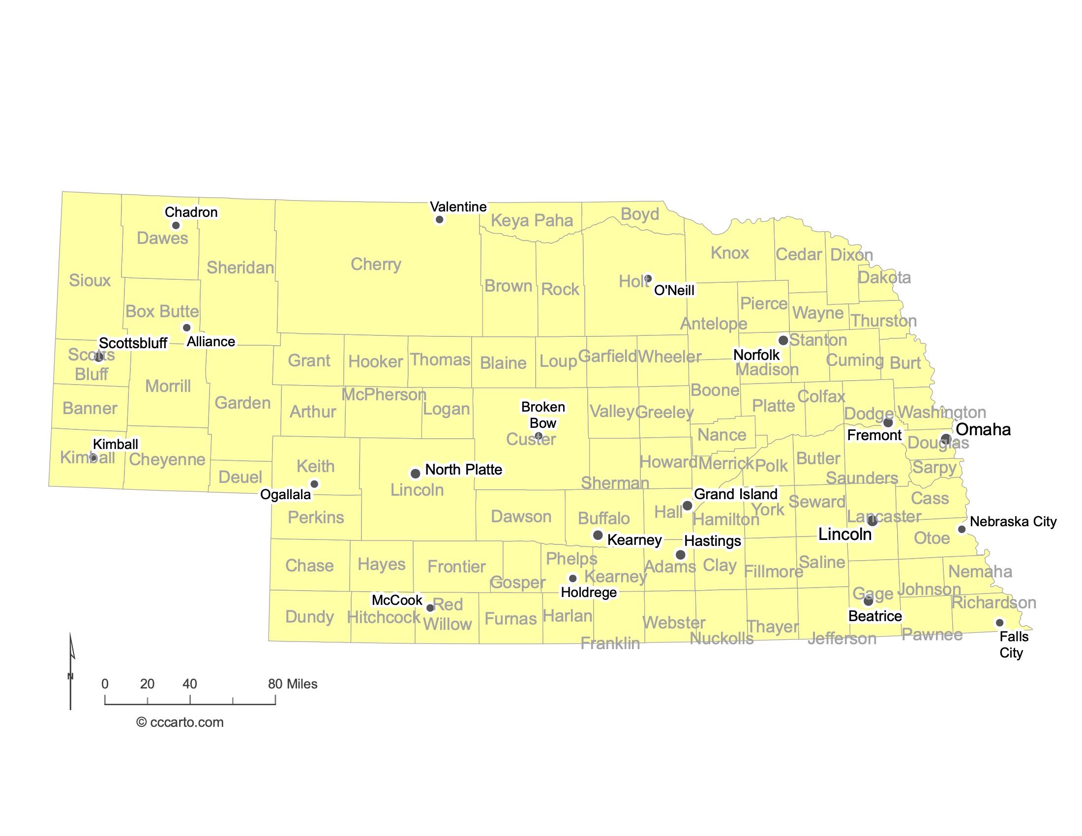
Major Cities of Nebraska | Nebraska Cities State Map
In Nebraska State, most major cities are located near important transportation routes or river systems. Below are some examples:
1. Omaha
Omaha is the largest city in Nebraska and is located along the Missouri River in the eastern part of the state. It is a major economic hub, known for its rich history in transportation and trade, particularly through its railroads and stockyards. Omaha is home to Fortune 500 companies and several cultural landmarks, including the Henry Doorly Zoo and the historic Old Market district.
2. Lincoln
Lincoln, the state capital, is located in southeastern Nebraska. It serves as the political and administrative center of the state and is home to the University of Nebraska. Lincoln is known for its vibrant downtown, historic buildings, and its role as a regional economic hub, particularly in education, healthcare, and government.
3. North Platte
North Platte is located in west-central Nebraska and is famous for its connection to the Union Pacific Railroad, specifically Bailey Yard, the largest railroad classification yard in the world. The city has a strong railroad history and offers a variety of attractions, including the Buffalo Bill Ranch State Historical Park.
4. Scottsbluff
Scottsbluff is located in western Nebraska near the Wyoming border. It is the largest city in the Nebraska Panhandle and serves as an agricultural and regional service center. The nearby Scotts Bluff National Monument is a prominent landmark, and the area is rich in pioneer history, playing a key role in the Oregon Trail.
5. Ogallala
Ogallala, located in southwestern Nebraska, was once a major stop along the historic cattle drives of the Texas Trail. Today, it is a gateway to Lake McConaughy, Nebraska's largest reservoir, offering recreational activities such as boating, fishing, and camping. Ogallala is also known for its Wild West history.
6. Grand Island
Grand Island is located in central Nebraska and is a key city for agricultural processing and transportation. It is home to the Nebraska State Fair and has a growing economy driven by manufacturing, agriculture, and retail. The city is also known for the Crane Trust, which protects the habitat of migrating sandhill cranes.
7. Kearney
Kearney is located in central Nebraska along the Platte River. It is a growing city with a strong economy based on agriculture, education, and manufacturing. Kearney is home to the University of Nebraska at Kearney and the Great Platte River Road Archway, which commemorates the westward expansion of the United States.
8. Norfolk
Norfolk, located in northeastern Nebraska, serves as a regional hub for agriculture and healthcare. The city has a rich railroad history and is a key commercial center for surrounding rural areas. Norfolk is also known for its parks and recreational areas along the Elkhorn River.
9. Falls City
Falls City is located in southeastern Nebraska, near the Missouri River. Historically, it was a key transportation and trading post. Today, Falls City is a smaller, agriculturally focused community with a rich history, including connections to early pioneers and river commerce.
10. Hastings
Hastings is located in south-central Nebraska and is known for its role in the development of Kool-Aid, the famous soft drink. The city has a strong agricultural base and is home to several historical sites, including the Hastings Museum. Hastings College is also located in the city, contributing to its educational and cultural offerings.
11. Valentine
Valentine is located in north-central Nebraska near the South Dakota border. Known as the "Heart City," Valentine is a gateway to the scenic Niobrara River Valley, which offers canoeing, tubing, and other outdoor recreational activities. The city is also near the Nebraska Sandhills and the Fort Niobrara National Wildlife Refuge.
12. McCook
McCook is located in southwestern Nebraska and is known for its agricultural economy and historical significance. It was the home of U.S. Senator George Norris, a key figure in New Deal legislation and rural electrification. The city also serves as a regional service center for surrounding rural communities.

Notable Federal Lands in Nebraska: Largest and Most Fascinating Destinations
1. Oglala National Grassland
Oglala National Grassland is located in the northwestern corner of Nebraska, near the borders with South Dakota and Wyoming. This vast grassland spans over 94,000 acres and is known for its wide-open prairies, buttes, and badlands. It offers opportunities for hiking, birdwatching, and exploring geological features like the Toadstool Geologic Park, which showcases ancient rock formations shaped by wind and water erosion.
2. Agate Fossil Beds National Monument
Agate Fossil Beds National Monument, located in northwestern Nebraska, is a significant paleontological site featuring some of the world's best-preserved Miocene Epoch fossils, including ancient mammals. Visitors can explore the museum and trails that highlight the fossil discoveries, as well as learn about the area's Native American heritage, particularly through its connection to the Lakota Sioux.
3. Nebraska National Forest
The Nebraska National Forest, which spans over 141,000 acres, is unique for its large hand-planted forest. Located in the Sandhills and Pine Ridge areas of Nebraska, it features a diverse mix of grasslands, forests, and recreational opportunities. Popular activities include camping, hiking, hunting, and observing wildlife. The Bessey Ranger District near Halsey contains one of the largest hand-planted forests in the world.
4. Valentine National Wildlife Refuge
Valentine National Wildlife Refuge, located in north-central Nebraska in the Sandhills region, covers more than 71,000 acres of grasslands, wetlands, and lakes. It serves as an important habitat for migratory birds and other wildlife. Visitors can enjoy birdwatching, fishing, and hiking, while the refuge's scenic lakes and rolling hills offer opportunities for outdoor recreation and wildlife observation.
5. Samuel R. McKelvie National Forest
Samuel R. McKelvie National Forest, located in north-central Nebraska, covers around 116,000 acres and is characterized by mixed grass prairie and ponderosa pine forests. It is a popular destination for camping, hiking, and birdwatching, offering visitors the chance to experience the beauty of Nebraska's Sandhills and its wildlife.
6. Fort Niobrara National Wildlife Refuge
Fort Niobrara National Wildlife Refuge is located near Valentine, Nebraska, and spans approximately 19,000 acres. The refuge is known for its diverse wildlife, including bison, elk, and prairie dogs, as well as its scenic Niobrara River, which is popular for canoeing and kayaking. Visitors can also explore the refuge's hiking trails and enjoy the beautiful Niobrara River Valley.
7. Hugh Butler Lake
Hugh Butler Lake, located in southwestern Nebraska, is a man-made reservoir offering a variety of recreational activities such as boating, fishing, and camping. The lake is surrounded by scenic landscapes and is popular for anglers looking to catch walleye, white bass, and crappie. It also provides important habitat for migratory birds and other wildlife.
8. DeSoto National Wildlife Refuge
DeSoto National Wildlife Refuge is located along the Missouri River on the Nebraska-Iowa border. It spans more than 8,000 acres and is a key stopover point for migratory birds, particularly snow geese and bald eagles. The refuge also has historical significance, as it preserves the remains of the steamboat Bertrand, which sank in 1865. Visitors can explore the museum, view wildlife, and enjoy hiking and fishing in the area.
9. North Platte National Wildlife Refuge
North Platte National Wildlife Refuge is located in western Nebraska and encompasses several bodies of water, including Lake Minatare. It provides critical habitat for migratory waterfowl, bald eagles, and other wildlife. The refuge offers recreational opportunities such as wildlife viewing, birdwatching, fishing, and photography, making it a popular destination for nature enthusiasts.

Nebraska Topographic State Map | Shaded Relief
Nebraska State offers a diverse range of terrains, shaped by its unique geology, climate, and natural features. From vast grasslands to rolling sand dunes, and from river valleys to rugged buttes, the state presents a rich tapestry of landforms. Below are some of the key topographic features that define Nebraska’s landscape:
1. Nebraska Sandhills
The Sandhills, located in north-central Nebraska, are the largest sand dune formation in the Western Hemisphere, covering nearly a quarter of the state. These stabilized dunes are covered with native grasses and serve as critical recharge areas for the High Plains Aquifer.
2. Loess Hills
These hills, found in the eastern part of Nebraska, were formed by wind-deposited silt called loess during the last Ice Age. The rolling hills provide fertile soils for agriculture and are a distinctive feature of the state’s topography.
3. Pine Ridge
Located in the northwestern part of Nebraska, Pine Ridge is a rugged escarpment covered with ponderosa pine forests. It features cliffs, canyons, and buttes, offering a stark contrast to the surrounding plains. The region is home to wildlife such as bighorn sheep and provides opportunities for hiking and camping.
4. Platte River Valley
The Platte River Valley runs through the heart of Nebraska, providing a wide, flat corridor that has historically been an important route for transportation and migration. The river supports extensive agriculture and serves as a critical stopover for migratory birds like sandhill cranes.
8. Ogallala High Plains
The western part of Nebraska is characterized by the high plains, which feature flat to gently rolling terrain. This region is semi-arid and primarily used for cattle ranching and dryland farming. The Ogallala Aquifer, a key water source for the region, lies beneath these plains.
9. Scotts Bluff National Monument
Scotts Bluff, located in western Nebraska, is a prominent geological formation that served as an important landmark for pioneers traveling the Oregon Trail. The towering bluff and surrounding badlands provide a dramatic contrast to the flat plains and are a popular destination for visitors.

Nebraska Ecoregions State Map | EPA Ecological Zones
Central Dissected Till Plains Section
This ecoregion is characterized by rolling hills and valleys formed by glacial deposits. The fertile soils in this region support extensive agriculture, particularly corn and soybean farming. The landscape includes a mix of grasslands, woodlands, and agricultural fields.
Central High Plains Section
The Central High Plains feature flat to gently rolling terrain, with a mix of shortgrass prairie and agricultural land. This ecoregion experiences a semi-arid climate and is dominated by ranching and dryland farming, with crops like wheat and sorghum.
Central High Tablelands Section
This ecoregion consists of elevated, flat tablelands that are dissected by canyons and river valleys. The area is primarily used for cattle grazing, with some irrigated agriculture in the river valleys. The dry climate and higher elevation give this region a distinctive landscape.
Central Loess Plains Section
The Central Loess Plains are characterized by deep loess (wind-blown silt) deposits, which create gently rolling hills. The region is primarily agricultural, with productive soils that support corn, soybeans, and wheat. Grasslands remain in less developed areas.
Nebraska Sand Hills Section
The Nebraska Sand Hills are the largest dune field in the Western Hemisphere, covered in native grasses. This unique ecoregion is largely undisturbed and supports cattle ranching. The Sand Hills are critical for groundwater recharge and are home to a variety of wildlife.
North-Central Glaciated Plains Section
This ecoregion is marked by its glacial history, with rolling hills, flat plains, and numerous wetlands and lakes. Agriculture is dominant here, with corn, soybeans, and wheat as major crops. Wetlands in this region provide important habitat for migratory birds.
North-Central Great Plains Section
The North-Central Great Plains are characterized by a mix of grasslands and cropland. This region has more rugged topography than the Central High Plains, with ridges, valleys, and occasional badlands. Agriculture and ranching are the primary land uses.
Northwestern Great Plains Section
The Northwestern Great Plains feature a semi-arid climate, rolling hills, and large areas of native grassland. This sparsely populated region is mainly used for cattle grazing, with limited agriculture. The ecoregion also includes some areas of exposed bedrock and badlands.
South-Central Great Plains Section
This ecoregion is known for its broad, flat plains and extensive agriculture, including irrigated crops. The climate is semi-arid, and much of the natural grassland has been converted to cropland. The region also contains important aquifers that support irrigation.
Western Glaciated Plains Section
The Western Glaciated Plains are characterized by rolling terrain and small hills formed by glacial activity. This ecoregion has fertile soils and supports a mix of agriculture and prairie. It is an important area for both farming and wildlife habitats, particularly for migratory birds.

Nebraska Physiographic Regions State Map
Central Lowland, Dissected Till Plains
This region is characterized by rolling hills and valleys that were formed by glacial deposits during the last Ice Age. The fertile soils in the Dissected Till Plains support extensive agriculture, particularly corn and soybean production. The terrain is primarily composed of loess, glacial till, and alluvial deposits, with numerous rivers and streams crisscrossing the landscape.
Great Plains, High Plains
The High Plains are a flat to gently rolling region that forms part of the western Great Plains. This area is semi-arid, with much of the land used for cattle ranching and dryland farming. The High Plains are distinguished by their higher elevation and extensive grasslands, with some areas irrigated for crops like wheat and sorghum.
Great Plains, Missouri Plateau, Glaciated
The Glaciated Missouri Plateau lies in northeastern Nebraska and extends into the Dakotas. This region features rolling hills and valleys shaped by glacial deposits, with areas of wetlands, lakes, and rivers. The fertile soils here are highly suitable for agriculture, with corn, soybeans, and wheat being the primary crops. The region also supports important wildlife habitats.
Great Plains, Missouri Plateau, Unglaciated
Located in western Nebraska, the Unglaciated Missouri Plateau has a more rugged topography compared to its glaciated counterpart. This region is characterized by steep valleys, buttes, and badlands. It is primarily used for cattle ranching, with limited crop production due to the dry climate and rocky terrain. The area retains much of its native grassland and wildlife habitats.
Great Plains, Plains Border
The Plains Border region lies along the western edge of the Great Plains and is marked by its transitional geography between the flat plains and the more rugged terrain of the Rocky Mountains. This region includes areas of rolling hills, mesas, and river valleys. It supports a mix of agriculture and grazing, and is known for its natural beauty and outdoor recreational opportunities.