

New Hampshire State Maps | Complete Map Collection
New Hampshire State Maps: Detailed Maps for Counties, Cities, Federal Areas, Physiographic & Ecoregions
Welcome to our comprehensive collection of New Hampshire State Maps, meticulously curated to provide detailed, high-resolution visualizations of the state’s geography, political boundaries, and natural regions. These maps are designed for students, researchers, planners, and anyone seeking an in-depth visual reference.
- Counties and Cities: Clearly defined county boundaries and major cities for planning, education, and demographic reference.
- Federal Areas: National parks, forests, monuments, wildlife refuges, military installations, and other federally managed lands.
- Physiographic Regions: Major landforms and terrain features such as mountains, plains, valleys, plateaus, and coastal areas.
- Ecoregions: Ecological zones representing forests, grasslands, deserts, wetlands, and other biodiversity regions.
Map Profile
- Format: JPEG
- Color: RGB
- Resolution: ~72 DPI
- Typical image size: ~1300 × 1700 px
- Paper size: Letter (8.5 × 11 inches)
- Layouts: Portrait and Landscape
- File size: ~100–500 KB
Print tip: In your print dialog select Letter (8.5×11), choose Portrait or Landscape, and use Fit to Page (or Scale - to fit).

New Hampshire Counties Interesting Facts
New Hampshire’s 10 counties range from the White Mountains to a short but busy seacoast; urban growth concentrates in Hillsborough.
- Number of counties: 10 — NH.gov
- First & last established: First four in 1769; newest were Belknap & Carroll (1840) — Newberry Atlas
- Highest & lowest county: Highest Mount Washington in Coös County; lowest at sea level in Rockingham County — USGS
- Most & least populated: Most: Hillsborough; Least: Coös
- Least & most developed: Most: Hillsborough; Least: Coös
- Most geographically diverse: Grafton County (Franconia & Pemigewasset ranges, major rivers, lakes)
- Strangest-shaped county: Coös County — sprawling “north country” wedge with long borders
- State’s Biggest Commodity: Dairy & eggs among the top cash-receipt leaders; greenhouse/floriculture is a chief crop sector. USDA NASS State Overview, Farm Flavor (2024).
- State’s Biggest Employer (private): Dartmouth Health (Dartmouth-Hitchcock). About Dartmouth Health.
- Top 3 Languages (besides English): Spanish, French, Chinese. Census/ACS (DataUSA), NH Center for Justice & Equity (ACS brief).
About CCCarto – New Hampshire State Maps Creator
CCCarto has been producing professional digital and GIS maps for large companies, government agencies, and educational institutions since 1988. With over 35 years of cartographic experience, our New Hampshire state maps are designed to the highest standards of accuracy, clarity, and usability.
Our map collection spans counties, cities, federal lands, ecoregions, physiographic regions, topographic relief, and more — giving students, researchers, educators, planners, and curious explorers the best New Hampshire state map resources available online. Every map is optimized for both screen viewing and letter-size printing.
Explore our full U.S. State Maps collection, or browse our Geology Maps, Travel Maps, and Energy Maps.
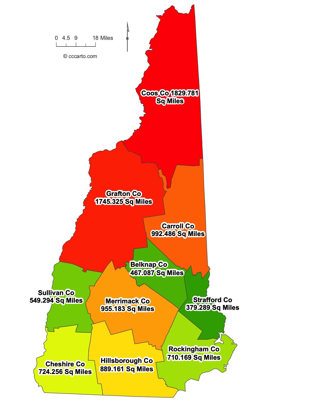
New Hampshire County Sizes State Map
Smallest County in New Hampshire State
Belknap County: 467 sq miles
Largest County in New Hampshire State
Coos County: 1829 sq miles
Mean and Median Area of Counties in New Hampshire State
Mean Area: 852.50 sq miles
Median Area: 797.5 sq miles
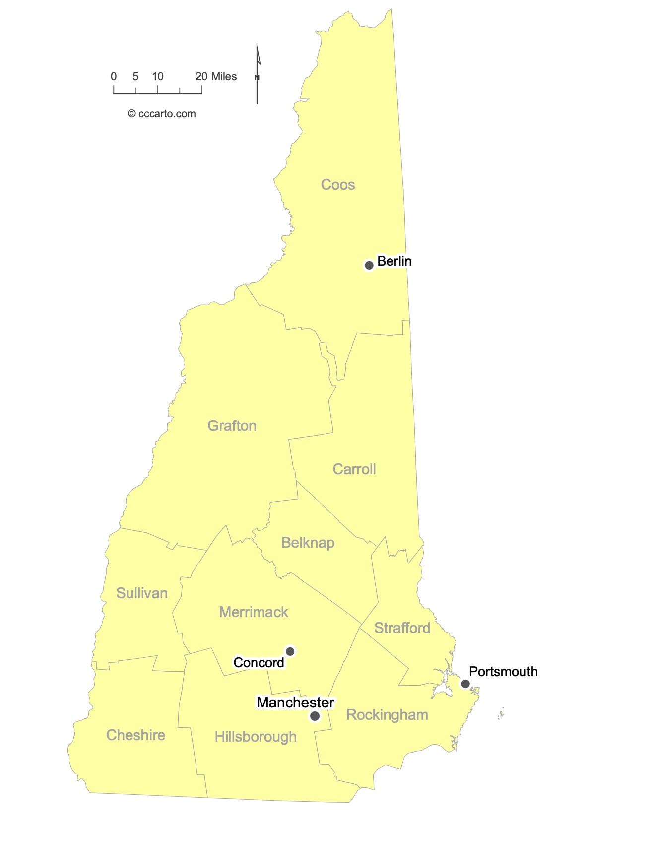
Major Cities of New Hampshire | New Hampshire Cities State Map
In New Hampshire State, most major cities are strategically located along rivers or historic transportation routes. Below are examples of each type:
1. River Ports
Manchester: The largest city in New Hampshire, located along the Merrimack River, historically facilitating trade and commerce. Its riverside location contributed to its growth into an important economic hub.
Nashua: Located south of Manchester, Nashua is another significant river city, benefiting from its proximity to the Merrimack River, which has been a vital part of its growth.
2. Historic Paths or Routes
Concord: Concord grew as a key stop along historic trade routes, serving as New Hampshire's capital and a center of industry and commerce.
Dover: Located near the seacoast, Dover’s history as a manufacturing hub and its position near historic routes made it a key city in the state's development.
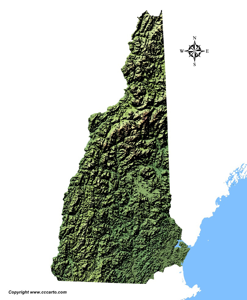
New Hampshire Topographic State Map | Shaded Relief
New Hampshire offers diverse terrains, shaped by its unique geology and climate. From the White Mountains to coastal lowlands, the state presents a rich variety of landscapes.
1. Coastal Lowlands
The southeastern edge of New Hampshire features low-lying coastal areas along the Atlantic Ocean. This region includes tidal flats, estuaries, and wetlands. The coastal area, where cities like Portsmouth are located, provides rolling hills and flatlands. This area is known for its moderate climate and rich soils.
2. White Mountain Range
Running north through the central part of the state, the White Mountain Range is one of New Hampshire’s defining geographic features. The range includes towering peaks like Mount Washington (6,288 feet), the highest in the northeastern United States. The mountains feature rugged cliffs, alpine meadows, and forested slopes.
3. New England Uplands
Located in the western portion of the state, the New England Uplands consist of hilly and forested areas, with an elevation lower than the White Mountains but higher than the coastal plains. The landscape is dotted with rolling hills and river valleys.
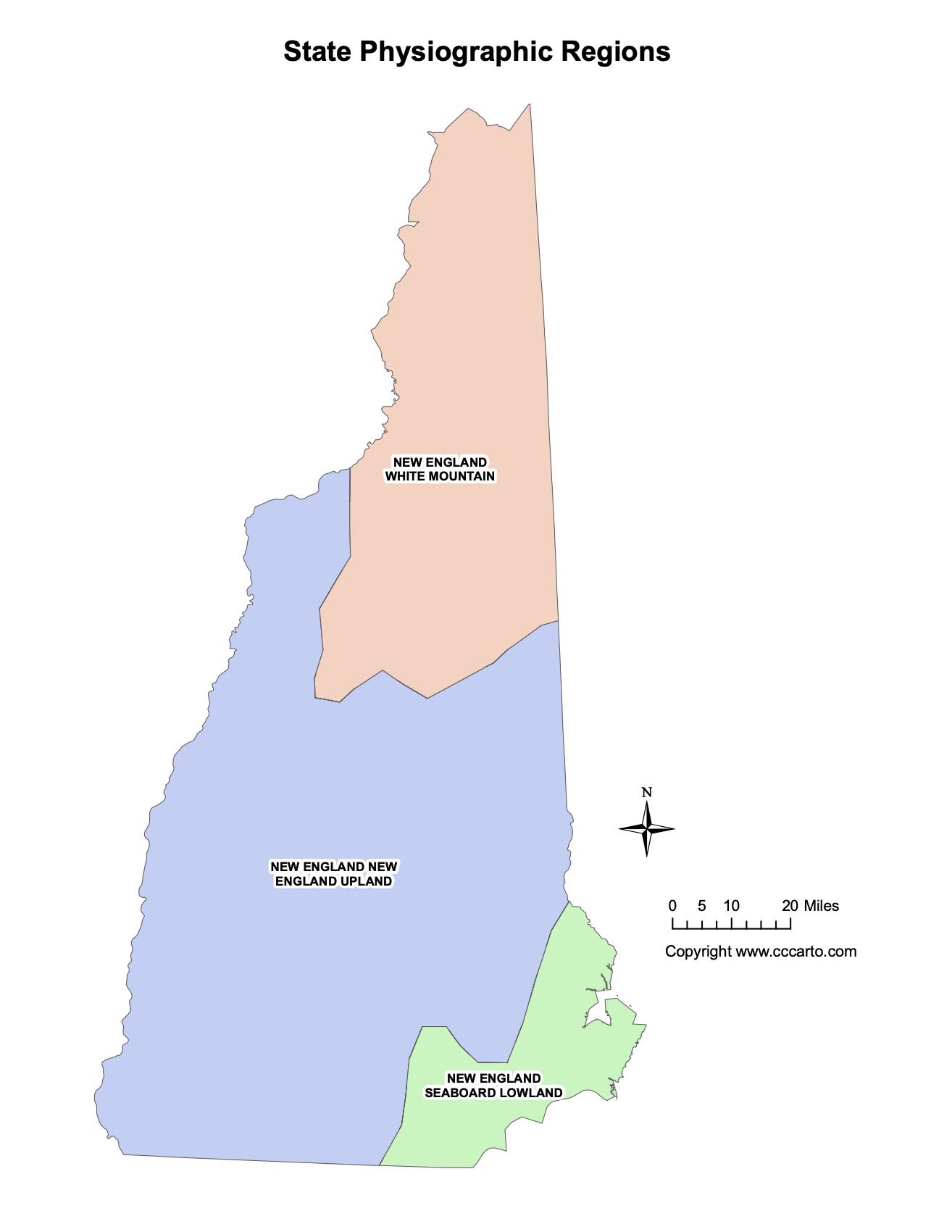
New Hampshire Physiographic Regions State Map
New England Upland
The New England Upland covers much of the western and central regions of New Hampshire, characterized by rolling hills, dense forests, and small mountain ranges. The region is rich in both hardwood and evergreen forests, and its terrain is shaped by glaciation.
Seaboard Lowland
The Seaboard Lowland, located along New Hampshire’s eastern seacoast, features relatively flat terrain, estuaries, and wetlands. Its proximity to the Atlantic Ocean influences its climate and vegetation.
White Mountain
The White Mountain region dominates northern New Hampshire and is the highest and most rugged part of the state. This region is known for its steep peaks, alpine environments, and iconic Mount Washington.
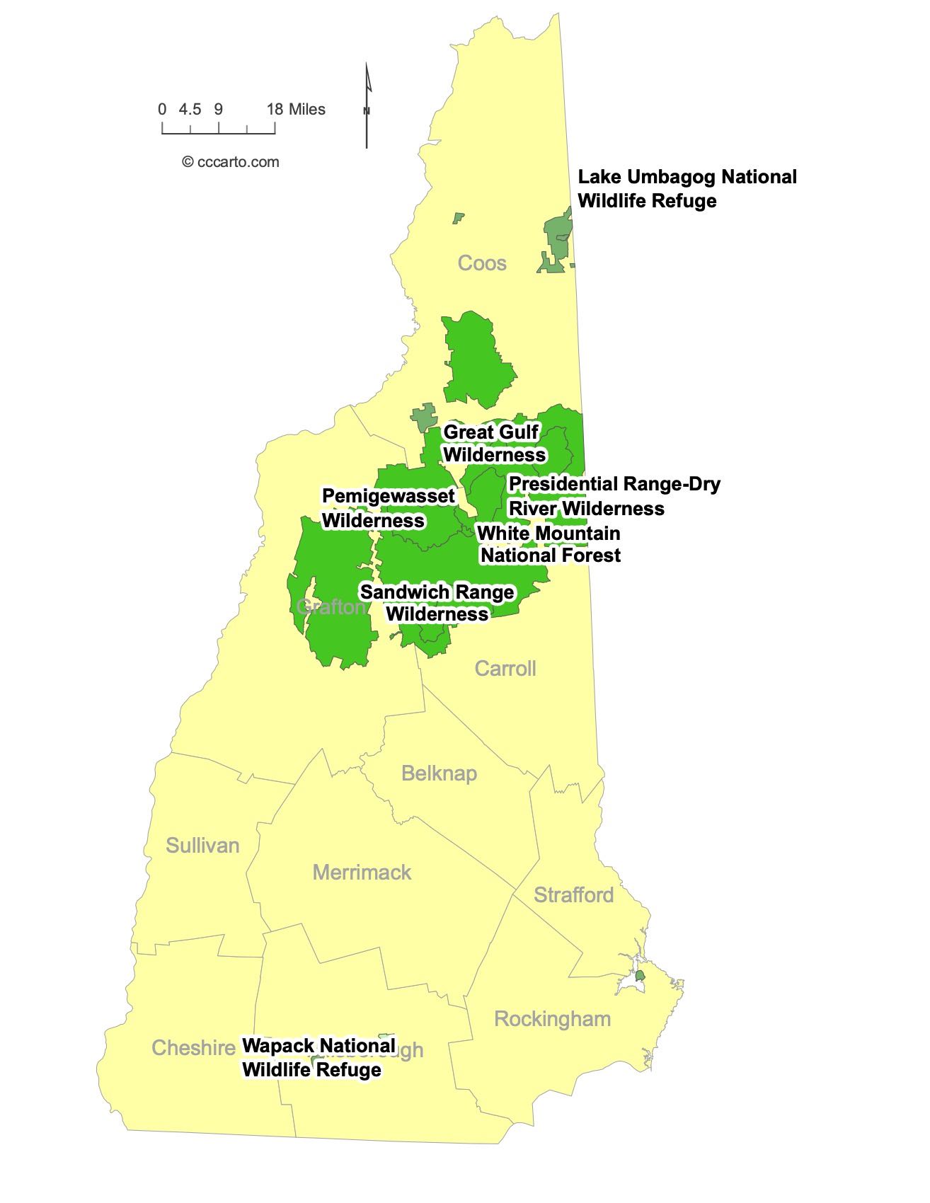
Notable Federal Lands in New Hampshire: Largest and Most Fascinating Destinations
1. White Mountain National Forest
White Mountain National Forest is one of the most iconic federal lands in New Hampshire. It encompasses the rugged White Mountains and offers diverse ecosystems, from dense forests to alpine meadows. Visitors can explore scenic drives, campgrounds, and numerous trails, making it a prime destination for both casual tourists and serious hikers.
2. Appalachian National Scenic Trail
Part of the Appalachian Trail runs through New Hampshire, including a scenic stretch through the White Mountains. The trail offers some of the most challenging and scenic hiking along its entire length.
3. Sandwich Range Wilderness
The Sandwich Range Wilderness, located within the White Mountain National Forest, covers over 35,800 acres. It is known for its rugged terrain, pristine forests, and scenic hiking trails, including the Sandwich Dome and Mount Tripyramid. The area is popular for backcountry hiking and wildlife viewing.
4. Lake Umbagog National Wildlife Refuge
Lake Umbagog National Wildlife Refuge is located in northern New Hampshire and Maine. It protects over 25,000 acres of wetlands, forests, and lakeshore habitat, providing sanctuary for a wide variety of wildlife. The refuge offers opportunities for canoeing, kayaking, birdwatching, and fishing.
5. Pemigewasset Wilderness
Covering approximately 45,000 acres, the Pemigewasset Wilderness is the largest wilderness area in New Hampshire. It is located within the White Mountain National Forest and is known for its remote and rugged landscape, including forests, rivers, and mountain peaks. The wilderness offers solitude for hikers and backpackers exploring the numerous trails, including the famous Bondcliff and Franconia Ridge.
6. Great Gulf Wilderness
The Great Gulf Wilderness is a 5,500-acre area situated between the Presidential Range peaks. Known for its steep ravines and alpine environments, this wilderness area is home to some of the most challenging trails in the White Mountains, including ascents to Mount Washington. It offers dramatic views and pristine backcountry hiking.
7. Wapack National Wildlife Refuge
The Wapack National Wildlife Refuge, located in southern New Hampshire, covers 1,625 acres. It is home to diverse wildlife and provides habitat for migratory birds. The refuge includes a section of the Wapack Trail, a popular hiking trail offering scenic views of the surrounding mountains and forests.
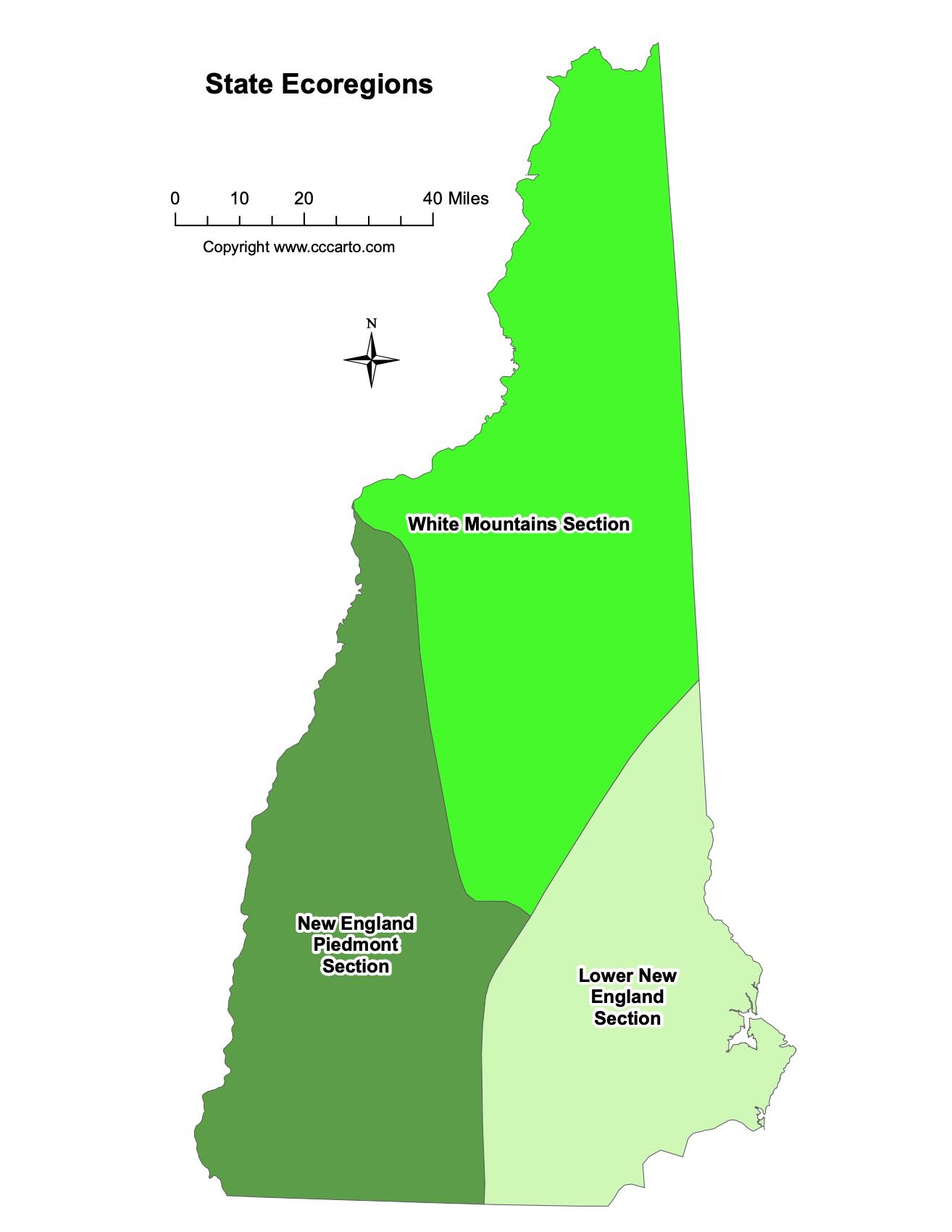
New Hampshire Ecoregions State Map | EPA Ecological Zones
Lower New England Section
This ecoregion encompasses southern New Hampshire, with a mix of forests, rivers, and agricultural land. It is a transition zone between the coastal and upland areas of the state.
New England Piedmont Section
The New England Piedmont extends into central New Hampshire and features a hilly landscape, mixed hardwood forests, and numerous lakes. This ecoregion is important for timber and recreational activities like hiking and boating.
White Mountains Section
The White Mountains ecoregion is characterized by high-elevation forests, alpine meadows, and steep, rocky slopes. It supports a unique range of plant and animal life and is a key area for outdoor recreation in the state.