
Oil Field Maps
Oman Oil Fields Map
Oman's oil history dates back to the early 20th century, but the country's oil industry truly began to develop in the late 1960s. Oil was discovered in Oman in 1964, with commercial production starting in 1967. The discovery of oil was pivotal for Oman, as it transformed the country's economy and allowed for significant modernization and development. The early success of oil exploration led to rapid economic growth, with the government investing heavily in infrastructure, healthcare, and education.
Forty years ago, in the 1980s, Oman was experiencing a peak in its oil exploration and production activities. The country had a relatively large number of active oil fields and derricks compared to today. During this period, the major fields included the Yibal, Muri, and Nimr fields. The Yibal field, in particular, was significant due to its high production capacity. However, as of the 2020s, many of these fields have been in production for decades, leading to a natural decline in output and necessitating more advanced techniques to maintain production levels.
Currently, Oman has significantly fewer active oil fields and derricks than it did 40 years ago. The oil industry in Oman has shifted towards enhanced oil recovery techniques to extract more oil from existing fields, as well as exploring new fields. The decline in the number of active fields is partly due to the natural depletion of older fields and the increasing costs associated with maintaining and operating older infrastructure.
In terms of the largest oil and gas fields in Oman, the key fields include the Fahud, Yibal, and Khazzan fields. The Fahud field is one of the oldest and largest, with its production beginning in the 1970s. It has been crucial in supplying a significant portion of Oman's oil. The Yibal field, discovered in the 1960s, has been a major contributor to the country's oil production but has seen declining output. The Khazzan field, which started production in the mid-2010s, is a significant gas field and represents a major development in Oman's hydrocarbon sector, with a large production capacity.
As for how soon the oil will run out, it's difficult to predict precisely. The lifespan of an oil field depends on various factors including the technology used, market conditions, and investment in new exploration. With current technology and enhanced recovery methods, Oman is expected to continue producing oil for several more decades. However, the industry is facing challenges such as declining production rates from older fields and fluctuating global oil prices, which impact the profitability and sustainability of oil extraction.
Oman's oil industry is transitioning towards sustainability, with efforts to diversify the economy away from oil dependence and invest in renewable energy sources. This strategic shift is crucial for ensuring long-term economic stability and addressing the challenges posed by declining oil reserves.
Can Oman Bypass the Strait of Hormuz for a Safer Shipping Route???
The Musandam Bypass Canal: Visual Appeal vs. Engineering Reality
The topographical relief on maps of the Musandam Peninsula highlights exactly why this concept is so tempting. Visually, the narrow land bridges in the intricate fjord system look like perfect candidates for a bypass canal to avoid the Strait of Hormuz. However, translating that visual into a functional waterway for Very Large Crude Carriers (VLCCs) runs into severe geological, engineering, and strategic roadblocks.
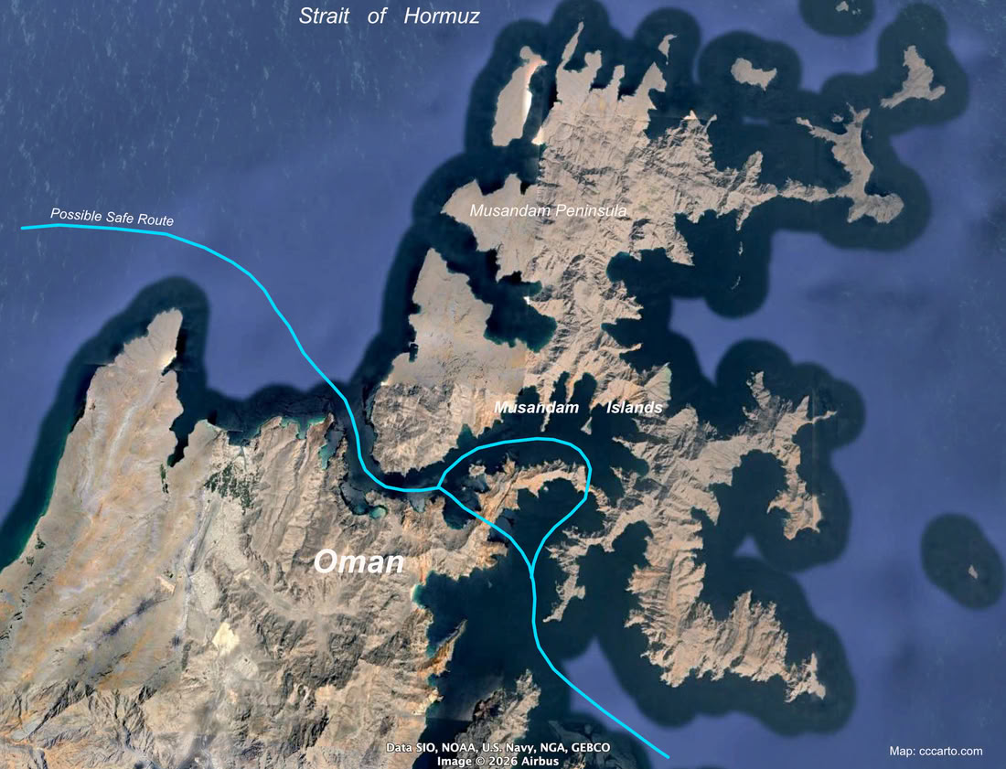
Possible New Strait of Hormuz Bypass?
The Engineering Reality
The Musandam Peninsula is essentially a series of steep, jagged limestone mountains (the Hajar range) plunging directly into the sea. To create a navigable passage for modern oil ships, the engineering requirements would be monumental:
- Massive Excavation: The narrowest points are solid rock. It would require drilling, blasting, and dredging millions of cubic meters of limestone.
- Accommodating VLCCs: A fully loaded modern oil tanker requires a draft of at least 65 to 80 feet (20 to 25 meters) and is over 200 feet wide. The channel would need to be excavated to a depth of at least 100 feet to allow for safe under-keel clearance.
- Tidal Dynamics: The Strait of Hormuz handles massive tidal exchanges. Punching a narrow hole through the peninsula would create a severe hydrodynamic funnel, resulting in a dangerous tidal race (extremely fast, turbulent currents). This is one of the reason slow turning oil tankers don't cut the Oman coast closer.
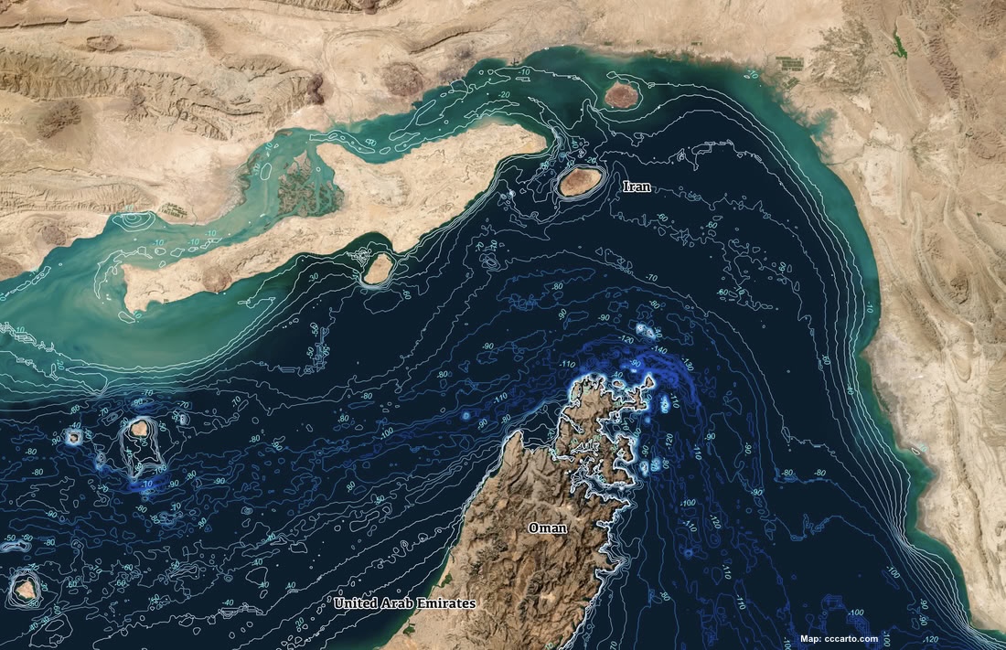
Strait of Hormuz Depth Map
The Strategic Paradox
The primary goal of this bypass is to avoid mines and military blockades. Unfortunately, a narrow canal is infinitely more vulnerable to these threats than the open waters of the Strait.
- The Ultimate Chokepoint: A canal is the easiest maritime feature to block. A single sunken ship (by accident or sabotage) would instantly render the multi-billion-dollar passage useless. The 2021 Ever Given container ship, getting stuck in the Suez Canal from March 23 to March 29, 2021 is a perfect example.
- Proximity: The Musandam Peninsula is only about 30 miles from the Iranian coast. Any infrastructure built here is well within range of basic coastal artillery and short-range missiles.
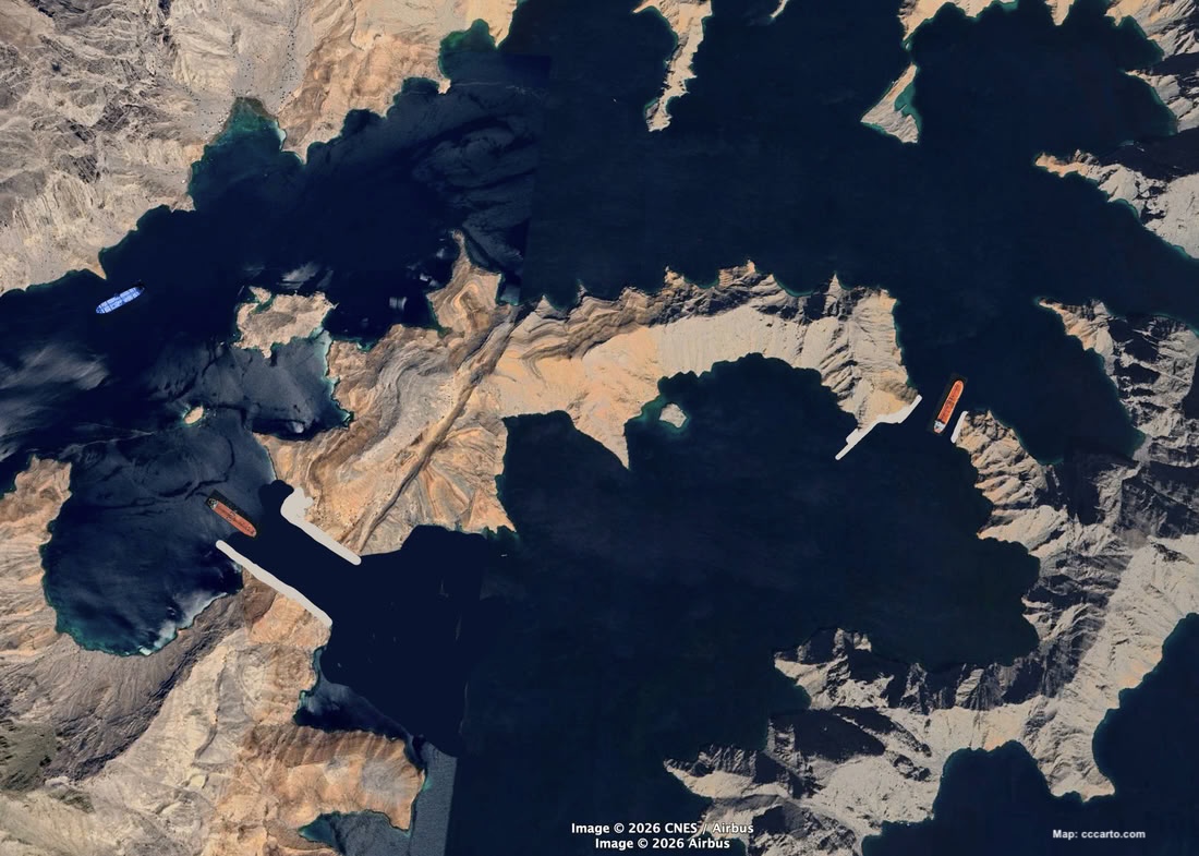
Possible New Striat of Hormuz Route Map?
The Environmental Impact
Often referred to as the "Norway of Arabia," the Musandam fjords hold a highly sensitive and biodiverse marine ecosystem. The environmental devastation of a canal project would be absolute:
- Acoustic and Physical Destruction: The underwater blasting required to carve the channel would decimate local marine life, including dolphins, whale sharks, and sea turtles.
- Siltation: The sheer volume of pulverized limestone suspended in the water column during construction would choke the extensive coral reefs in the surrounding khawrs.
- Operational Hazards: Introducing massive, continuous heavy shipping traffic into an enclosed fjord system guarantees severe ecological degradation from noise pollution, ballast water discharge, and the risk of a catastrophic oil spill.
The Real-World Alternative
Rather than attempting to cut a expensive and timely canal for ships, the established method for bypassing the Strait of Hormuz relies on moving the oil itself overland. The Habshan–Fujairah oil pipeline in the neighboring United Arab Emirates pumps over a million barrels of crude oil a day from Abu Dhabi directly across the desert to the port of Fujairah on the Gulf of Oman, bypassing the maritime chokepoint entirely. They need to build more. Would keep the gulf ship traffic less crowded, safer, and cleaner.
Field Acronyms
EUR_MMBOE = Estimated ultimate recovery in million barrels of oil equivalent
Giant oil and gas fields = those with 500 million barrels (79,000,000 m3) of ultimately recoverable oil or gas equivalent.
Super giant oil field = holds equivalent of 5.5bn barrels of oil reserves.
Oman Oil Fields
Barik Field, Oman, Discovered 1991, Giant Field
Fahud Field, Oman, Discovered 1964, Giant Field
Khazzan Field, Oman, Discovered 2001, Giant Field
Lekhwair Field, Oman, Discovered 1968, Giant Field
Marmul Field, Oman, Discovered 1957, Giant Field
Natih Field, Oman, Discovered 1960, Giant Field
Nimr Field, Oman, Discovered 1980, Giant Field
Saih Nihayda Field, Oman, Discovered 1972, Giant Field
Saih Rawl Field, Oman, Discovered 1990, Giant Field
Yibal Field, Oman, Discovered 1962, Giant Field
Data Source: Dr. M. K. (Mike) Horn/AAPG Datapages compilation
Return to Map Index
Copyright CCCarto 2026