Find Washington Interstates and Federal Highways
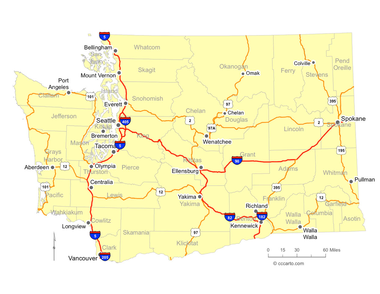
History of Interstates and U.S. Highways in Washington State
Washington State’s highway network evolved from Indigenous trade trails, military wagon roads, and early settler routes that followed river valleys, mountain passes, and coastal corridors. Long before statehood, Native American tribes established extensive travel networks connecting Puget Sound, the Columbia River, and the interior plateau. These routes later influenced the alignment of early territorial roads and, eventually, federal highways.
During the late 19th and early 20th centuries, Washington State focused on developing wagon roads and paved highways to support logging, mining, agriculture, and port access. Early east–west routes through Snoqualmie Pass and Stevens Pass became vital links between Puget Sound ports and inland farming and resource regions. The creation of U.S. Highways in the 1920s formalized many of these corridors, including U.S. 2, U.S. 12, U.S. 97, and U.S. 101, which connected coastal communities, river ports, and interior towns.
U.S. 101 played a particularly important role in Washington State by forming a loop around the Olympic Peninsula, supporting timber production, fishing, military installations, and coastal tourism. U.S. 2 became a critical trans-Cascade route linking Everett to central and eastern Washington State, while U.S. 97 connected Canada to Oregon through agricultural regions and later became a major freight and trucking corridor.
The passage of the Federal-Aid Highway Act of 1956 transformed Washington State’s transportation system with the creation of the Interstate Highway System. Interstate 5 emerged as the backbone of the state’s transportation network, connecting Vancouver, British Columbia, to Oregon while linking Seattle, Tacoma, Everett, Olympia, and major ports. I-5 quickly became one of the most heavily traveled freight corridors on the West Coast, supporting international trade, military logistics, and commuter travel.
Interstate 90, the northernmost transcontinental interstate, cemented Washington State’s role as a gateway between the Pacific Northwest and the rest of the nation. Crossing Snoqualmie Pass, I-90 replaced older mountain highways and provided year-round reliability for freight, tourism, and defense transportation. Its construction required major engineering achievements, including extensive tunneling, avalanche mitigation, and large-scale bridge projects in the Puget Sound region.
Interstate 82 further strengthened Washington State’s highway system by connecting the Yakima Valley, Tri-Cities, and central agricultural regions to Interstate 90 and Interstate 84. This corridor became essential for moving agricultural products such as apples, wheat, wine grapes, and hops from farms to processing centers, ports, and national markets.
Federal highways and interstates in Washington State also played a strategic role during World War II and the Cold War. Highways supported shipyards, aircraft manufacturing, military bases, and nuclear facilities, including routes serving the Hanford Site and Puget Sound naval installations. These investments permanently shaped urban growth, industrial development, and suburban expansion throughout the state.
In the late 20th and early 21st centuries, Washington State shifted focus toward modernization, seismic safety, and congestion management. Aging infrastructure, population growth, and freight demand led to major reconstruction efforts on I-5, I-90, and I-405. Projects increasingly incorporated environmental mitigation, wildlife crossings, noise reduction, and stormwater management to balance transportation needs with environmental protection.
Landmark projects such as the SR 520 floating bridge replacement and Alaskan Way Viaduct removal highlighted Washington State’s leadership in complex highway engineering. Floating bridges across Lake Washington, earthquake-resistant designs, and urban tunneling solutions reflect the state’s unique geographic and seismic challenges. These projects also reinforced the integration of state highways with transit, ferries, and port infrastructure.
Today, Washington State’s Interstate and federal highway system remains central to trade, tourism, agriculture, and daily life. The network supports global commerce through ports in Seattle, Tacoma, and Vancouver while maintaining critical north–south and east–west mobility. Ongoing investments continue to modernize corridors, improve safety, and ensure Washington State’s highways remain resilient in the face of population growth, climate impacts, and evolving transportation demands.
Why all the 1926 dates? The year 1926 was significant for the U.S. highway system because it marked the official establishment of the U.S. Numbered Highway System, also known as the U.S. Highway System. This system was created by the American Association of State Highway Officials (AASHO), now known as the American Association of State Highway and Transportation Officials (AASHTO), in cooperation with the federal government. Here’s why 1926 was pivotal:
- Standardization of Routes: Prior to 1926, roads in the United States were a patchwork of local and state routes, often inconsistently marked and poorly maintained. The U.S. Highway System brought about a standardized network of numbered routes, designed to provide uniformity across state lines, making travel more predictable and navigable for drivers.
- National Connectivity: The new system connected rural and urban areas across the country, linking small towns and cities with major economic hubs. This was essential for improving the transportation of goods and services, helping to bolster the national economy.
- Designation of Major Routes: Iconic highways such as U.S. 1 (from Maine to Florida) and U.S. 66 (from Chicago to Los Angeles, later known as "Route 66") were part of this network. These routes became crucial arteries for cross-country travel, commerce, and later, American culture.
- Foundation for the Interstate System: The 1926 U.S. Highway System laid the groundwork for the more advanced Interstate Highway System, which was developed decades later in the 1950s under President Eisenhower. Many U.S. Highways continue to serve alongside interstates, and some of the old U.S. highways are still in use today.
The year 1926 thus represents the beginning of a modern, structured approach to road travel in the United States, which revolutionized transportation and mobility across the country.
Washington's Hardest Roads to Build
Washington State's terrain — deep water crossings, volcanic mountain passes, and isolated rainforest coastline — made several of its highways among the most difficult ever constructed in the United States. Three routes stand out as particularly extraordinary engineering feats.
I-90 — Lake Washington: World's Longest Floating Highway Bridge
Crossing Lake Washington east of Seattle required a solution no other highway had attempted at this scale: floating the road on the surface of the water itself. The lake's soft lakebed and exceptional depth made conventional piling impractical, so engineers anchored concrete pontoons to the lake floor and built the roadway on top of them. The result was the world's longest floating highway bridge. What made the achievement even more remarkable was the price of getting there — two earlier floating bridges across Lake Washington sank, one catastrophically during a 1990 storm when open hatches allowed water to flood the pontoons. Each failure forced engineers to rethink anchoring, ballast, and wave-load design. The final I-90 crossing, completed in 1993, incorporated lessons from those disasters and remains one of the longest floating bridges on Earth.
US-2 — Stevens Pass: Cut Through the Cascades with No Prior Road
At 4,061 feet, Stevens Pass punches through the heart of the Cascade Range at an elevation that guarantees heavy snowfall, avalanche risk, and months of winter closure. Unlike Snoqualmie Pass, which had some prior wagon-road history, Stevens Pass was carved through solid Cascade granite with virtually no existing road infrastructure to build upon. Workers blasted through some of the hardest rock in the Northwest while simultaneously managing one of the most active avalanche corridors in the country. The pass's narrow valley walls funnel enormous wind and snow loads directly onto the roadway, requiring ongoing avalanche mitigation — including artillery-triggered slides, snow sheds, and closures — that continues today. Building US-2 here was not widening a trail; it was engineering a highway from raw mountain.
US-101 — Olympic Peninsula: America's Most Remote Highway Corner
The stretch of US-101 looping around the Olympic Peninsula occupies the most isolated corner of the contiguous U.S. highway system. Crews constructing this route between 1927 and 1931 faced conditions that were extreme in nearly every dimension: rainfall exceeding 200 inches per year in some stretches, soft and unstable soils saturated by relentless precipitation, dense old-growth forest with no clearance, and a near-total absence of existing infrastructure — no supply roads, no nearby towns, no established grades. Equipment had to be brought in over rough tracks or by water. The wet, acidic soil made foundations unreliable, and the sheer remoteness meant that every material, every worker, and every repair had to travel far to reach the jobsite. The completed highway opened one of the last roadless regions of the lower 48 to motor travel.
Busiest and Longest Federal Interstates and U.S. Highways in Washington
| Interstate or Highway | Length (mi) | Length (km) | Southern or Western Terminus | Northern or Eastern Terminus | Created |
|---|---|---|---|---|---|
| I-5 | 276 | 444 | Oregon Border | Canadian Border | 1956 |
| I-90 | 297 | 478 | Seattle, WA | Idaho Border | 1956 |
| I-82 | 143 | 230 | I-90 Junction | Oregon Border | 1967 |
| I-405 | 30 | 48 | Tukwila, WA | Lynnwood, WA | 1965 |
| U.S. 101 | 365 | 587 | Oregon Border | Olympia, WA | 1926 |
| U.S. 2 | 326 | 525 | Everett, WA | Idaho Border | 1926 |
| U.S. 12 | 430 | 692 | Aberdeen, WA | Idaho Border | 1926 |
| U.S. 97 | 322 | 518 | Oregon Border | Canadian Border | 1926 |
| U.S. 195 | 94 | 151 | Pullman, WA | Spokane, WA | 1926 |
| U.S. 395 | 277 | 446 | Oregon Border | Canadian Border | 1926 |
Washington Designated Highways
Washington Interstate Highway 5, I-5 N
Washington Interstate Highway 5, I-5 S
Washington Interstate Highway 82, I-82 E
Washington Interstate Highway 82, I-82 W
Washington Interstate Highway 90, I-90
Washington Interstate Highway 90, I-90 E
Washington Interstate Highway 90, I-90 W
Washington Interstate Highway 182, I-182 E
Washington Interstate Highway 182, I-182 W
Washington Interstate Highway 205, I-205 N
Washington Interstate Highway 205, I-205 S
Washington Interstate Highway 405, I-405 N
Washington Interstate Highway 405, I-405 S
Washington Interstate Highway 705, I-705 N
Washington Interstate Highway 705, I-705 S
Washington US Highway 2, Croft Ave
Washington US Highway 2, Croft Ave W
Washington US Highway 2, E Broadway
Washington US Highway 2, E Watson St
Washington US Highway 2, Morgan St
Washington US Highway 2, N Browne St
Washington US Highway 2, N Division St
Washington US Highway 2, N Newport Hwy
Washington US Highway 2, N Ruby St
Washington US Highway 2, N Union Ave
Washington US Highway 2, N Washington Ave
Washington US Highway 2, N Wenatchee Ave
Washington US Highway 2, NE Main St
Washington US Highway 2, S Browne St
Washington US Highway 2, S Division St
Washington US Highway 2, S Union Ave
Washington US Highway 2, S Washington Ave
Washington US Highway 2, S Wenatchee Ave
Washington US Highway 2, Stevens St
Washington US Highway 2, Sunset Hwy N
Washington US Highway 2, US-2
Washington US Highway 2, US-2 Bus
Washington US Highway 2, W 4th St
Washington US Highway 2, W Broadway
Washington US Highway 2, W Main Ave
Washington US Highway 2, W SR2
Washington US Highway 2, W Sunset Hwy
Washington US Highway 2, W Walnut St
Washington US Highway 2, W Watson St
Washington US Highway 12, Bridge St
Washington US Highway 12, Coppei Ave
Washington US Highway 12, E Heron St
Washington US Highway 12, E Main St
Washington US Highway 12, E Wishkah Blvd
Washington US Highway 12, E Wishkah St
Washington US Highway 12, Main St
Washington US Highway 12, Pine St
Washington US Highway 12, Preston Ave
Washington US Highway 12, RR 2
Washington US Highway 12, RR 5
Washington US Highway 12, US-12
Washington US Highway 12, US-12 E
Washington US Highway 12, US-12 W
Washington US Highway 12, Villard St
Washington US Highway 12, W Main St
Washington US Highway 97, Cascade Way
Washington US Highway 97, E Woodin Ave
Washington US Highway 97, Lewis and Clark Hwy
Washington US Highway 97, Main St
Washington US Highway 97, S Saunders St
Washington US Highway 97, S Whitcomb Ave
Washington US Highway 97, US-97
Washington US Highway 97, US-97 Alt
Washington US Highway 97, US-97 N
Washington US Highway 97, US-97 S
Washington US Highway 97, W Woodin Ave
Washington US Highway 97, Webster Ave
Washington US Highway 97, Whitcomb Ave
Washington US Highway 97A, US-97A
Washington US Highway 101, 1st Ave N
Washington US Highway 101, 1st St
Washington US Highway 101, 5th St
Washington US Highway 101, E 1st St
Washington US Highway 101, E Front St
Washington US Highway 101, E Heron St
Washington US Highway 101, E Lauridsen Blvd
Washington US Highway 101, E Robert Bush Dr
Washington US Highway 101, E Wishkah St
Washington US Highway 101, Levee St
Washington US Highway 101, Lincoln St
Washington US Highway 101, N Alder St
Washington US Highway 101, N Forks Ave
Washington US Highway 101, N Lincoln St
Washington US Highway 101, N Park St
Washington US Highway 101, N West Blvd
Washington US Highway 101, Pacific Way
Washington US Highway 101, Perry Ave
Washington US Highway 101, Riverside Ave
Washington US Highway 101, S Alder St
Washington US Highway 101, S Forks Ave
Washington US Highway 101, S G St
Washington US Highway 101, S H St
Washington US Highway 101, S Lincoln St
Washington US Highway 101, S Park St
Washington US Highway 101, S West Blvd
Washington US Highway 101, Simpson Ave
Washington US Highway 101, Spruce St E
Washington US Highway 101, Sumner Ave
Washington US Highway 101, US-101
Washington US Highway 101, US-101 N
Washington US Highway 101, US-101 S
Washington US Highway 101, W Curtis St
Washington US Highway 101, W Heron St
Washington US Highway 101, W Lauridsen Blvd
Washington US Highway 101, W Robert Bush Dr
Washington US Highway 101, W Wishkah St
Washington US Highway 195, Broadway St
Washington US Highway 195, Inland St
Washington US Highway 195, N Main St
Washington US Highway 195, S Inland Empire Way
Washington US Highway 195, S Main St
Washington US Highway 195, US-195
Washington US Highway 197, US-197
Washington US Highway 395, E 3rd Ave
Washington US Highway 395, N Division St
Washington US Highway 395, N Ely St
Washington US Highway 395, N Main St
Washington US Highway 395, N Oregon Ave
Washington US Highway 395, N Park St
Washington US Highway 395, S Ely St
Washington US Highway 395, S Main St
Washington US Highway 395, S Park St
Washington US Highway 395, Sr 395
Washington US Highway 395, US-395
Washington US Highway 395, US-395 N
Washington US Highway 395, US-395 S
Washington US Highway 395, W 3rd Ave
Washington US Highway 395, W 5th Ave
Washington US Highway 730, US-730