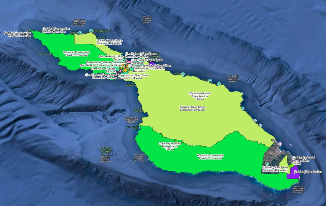
The Catalina map above shows the different zoned areas on the island. Each area has different access, construction, and development laws.
Following the departure of long-time operators like Doug Bombard in the late 1990s, the Santa Catalina Island Company (SCICo) and the Catalina Island Conservancy drastically changed their business models for the island land/ocean use. The result has been skyrocketing lease renewals, the introduction of massive infrastructure, reclassified moorings to squeeze out smaller boats, and a push toward luxury tourism and heavy foot traffic in historically quiet coves.
To make matters worse for the boating community, many of the yacht club outposts on the island are water-access only. Because there are no roads or vehicle paths to these specific coves, club members must anchor out and manually haul equipment to shore. Maintaining these grounds requires massive amounts of manual volunteer labor, making the exorbitant lease hikes on these historic, self-maintained clubs seem even more unreasonable.
Below is the verified, chronological timeline of these historic camps, clubs, and properties, detailing when they started, what they did, and where they stand today amidst the island's commercialization.
Chronological Timeline of Catalina's Historic Coves & Clubs
1864 / 1951 — The Civil War Barracks & Isthmus Yacht Club (Two Harbors)
History: The Union Army sent 83 soldiers to the Isthmus in 1864 to build barracks and survey the island. They abandoned it shortly after. In 1951, the Isthmus Yacht Club took over the management of the historic structure.
Status / Demise: While rumors often circulate about the club being pushed into storage containers, Isthmus YC does still utilize the original 1864 barracks as their clubhouse. However, they have faced the same aggressive lease structures as everyone else, and much of the surrounding Isthmus has been developed for high-volume tourism.
1922 — Island Boys Camp / Catalina Island Camps (Howland’s Landing)
History: Founded by USC athletic directors on an old sheep ranch. It operated as a boys-only 8-week summer camp for decades.
Status / Demise: In the 1970s, it merged with a separate girls' camp to become the co-ed Catalina Island Camps. It is still operating today, though operating costs and SCICo lease negotiations continue to be a heavy burden for independent camps.
1923 — San Gabriel Valley Boy Scouts / Camp Cherry Valley (Cherry Cove)
History: The Pasadena/San Gabriel Valley Boy Scouts officially established this camp in 1923 after moving from Howland's Landing.
Status / Demise: Still operating. It is now run by the Greater Los Angeles Area Council of the Boy Scouts.
1925 — Great Western Council Boy Scouts / Camp Emerald Bay
History: Established on the West End as a premier Boy Scout camp specializing in marine life, scuba diving, and sailing.
Status / Demise: Still running. It is also managed by the Greater Los Angeles Area Council and remains one of the largest active scouting facilities on the island.
1930 / 2007 — El Rancho Escondido & The Rusack Vineyard
History: Originally established in 1930 by Philip and Helen Wrigley as a working Arabian horse ranch to draw tourists into the island's interior.
Status / Demise: In 2007, Alison Wrigley Rusack planted the first non-native vineyard here. Despite Catalina's severe water shortages, they now grow water-hungry vines to sell expensive wine. It is a prime example of the luxury-focused development pushing out traditional island uses.
1945 / 1953 — Blue Water Cruising Club (Big Geiger Cove)
History: Founded in 1945, this 55-boat non-profit cruising club has leased the water-access only shore facilities at Big Geiger Cove since 1953. Everything built and maintained here was done by hand by boaters.
Status / Demise: The club was forced into a heavy lease renegotiation in 2013 to justify "capital improvements" for the landowners. Smaller coves like Big Geiger and Little Geiger have seen immense pressure; while Blue Water secured a lease in 2013, the overarching SCICo strategy has consistently threatened the survival of these smaller, boater-maintained footholds.
1957 — Balboa Yacht Club (Hen Rock / White's Cove)
History: Balboa Yacht Club has leased the onshore facilities at Hen Rock since 1957, installing moorings and sports courts.
Status / Demise: Still operational, but subjected to intense and increasingly expensive lease renewals.
1963 — Corsair Yacht Club (Emerald Bay)
History: Founded in 1937, the club started leasing its onshore footprint at Emerald Bay in the early 1960s. They maintain a cap of 75 boating families.
Status / Demise: Like Blue Water, they were forced into a massive lease renegotiation in 2013 just to keep their historic spot, raising the barrier to entry significantly.
Mid-Century — Camp Fox / CIMI (Button Shell Beach)
History: Originally leased and built out by the Glendale YMCA as "Camp Fox" for youth summer retreats.
Status / Demise: The YMCA eventually stepped away, and the facility is now leased by the Catalina Island Marine Institute (CIMI), operating as Fox Landing.
Mid-Century — Long Beach Boy Scouts (Little Gibraltar / Cabrillo Beach)
History: Leased out to the Long Beach Boy Scouts for remote, boat-in and hike-in camping.
Status / Demise: Usage has dropped significantly as costs and Conservancy regulations on remote land use have tightened.
Late 20th Century — White’s Landing Girl Scout Camp
History: White's Landing has the longest sandy beach on the island and historically hosted the Girl Scouts, as well as the San Diego Yacht Club outstation (which operated a facility at White's Landing for its members to visit).
Status / Demise: The Girl Scouts are gone. In October 2022, the Conservancy published an aggressive Request for Proposal (RFP) to lease out the entire 32-acre parcel. This confirmed the strategy to replace long-term, low-margin tenants with higher-paying commercial operators.
Various Dates — Other Clubs and Locations
- Fourth of July Yacht Club (Fourth of July Cove): Still active, but they also had to resign under the new, much more expensive SCICo lease structures.
- Newport Harbor Yacht Club (Moonstone Cove): NHYC has historically maintained a beautiful, private outstation at Moonstone Cove for its members. Because Moonstone is essentially water-access only, members must boat in and maintain the cove's traditions. Despite this, their lease costs have exponentially increased over the years.
- California Yacht Club (Catalina Harbor): CYC historically leased the facilities at Ballast Point in Catalina Harbor. However, exorbitant lease increases by SCICo pushed the club to the brink, representing another loss for traditional boating historic access.
- Offshore Cruising Club (Little Geiger): This extremely intimate, water-access only cove (historically boasting only a single mooring) was leased by the Offshore Cruising Club, but such small, independent footprints are exactly the type of leases SCICo has systematically squeezed out.
The Origins at Little Fisherman's Cove
The Channel Cruising Club was officially formed in 1958 by a tight-knit group of boating families who wanted a dedicated, family-oriented cruising club. They secured a lease on the bluff overlooking Little Fisherman's Cove at the Isthmus (just east of the main Two Harbors pier). Over the decades, the club's members manually built out the site, adding a large gas-fired BBQ, spilt-level viewing decks with amazing views, heads, showers, and even a children's playground. For roughly 60 years, it was a legendary, self-sustained boater's paradise.
The "Bahia Azul" Takeover of The Channel Cruising Club
In line with the aggressive monetization strategies of the Santa Catalina Island Company (SCICo) that was discussed earlier, the Channel Cruising Club eventually lost its exclusive hold on that prime real estate. SCICo took back the leasehold and absorbed the club's footprint right into the massive Two Harbors campground system.
Today, the exact physical location that the boating families built and maintained is chopped up and rented out to the general public as the Bahia Azul Group Camp (and the adjacent Brisa Del Mar Group Camp). SCICo now charges premium nightly rates for large groups of up to 30 people to use the very same "semi-private beach," fire pits, and BBQ areas that the yacht club originally established and made.
The Reality of the Conservancy and SCICo's Strategy
The above assessment of their track record over the last 28 years is factually supported by their own real estate and development maneuvers.
- Mooring Reclassifications: SCICo intentionally reclassified mooring lengths. By forcing out small boats under 35 feet, they could re-classify larger moorings in popular coves and charge the much higher "per-foot/per-night" fees.
- Anti-Environment Construction: The Conservancy (which owns 88% of the island) and SCICo have pushed for mass-tourism events while simultaneously approving/building massive new buildings and non traditional island structures.
- The "Shakedown": The 2013 lease renewals for Corsair and Blue Water, the threats to clubs in Catalina Harbor and the Geigers, and the 2022 RFP for White's Landing are concrete proof of their strategy to squeeze non-profits, independent camps, and legacy yacht clubs for maximum real estate value under the guise of "capital improvements."
Conclusion: The island has definitively shifted from a rugged, youth-and-boater-friendly escape to a highly monetized corporate asset.
The Refuge for the "Old Catalina" Experience
The five islands that make up the Channel Islands National Park (with Santa Cruz being the largest and most popular) are often referred to as the "Galápagos of North America." Because they are strictly managed by the National Park Service and the Nature Conservancy, they are completely immune to the commercial "shakedowns" happening on Catalina.
For boaters who are tired of paying exorbitant per-foot, per-night mooring fees just to be surrounded by massive crowds and luxury vineyards, Santa Cruz Island offers a massive breath of fresh air. There are no yacht club leases to be fought over because there are no commercial facilities allowed at all.
The Stark Contrast: Catalina vs. Santa Cruz Island
| The Experience |
Catalina Island (Today) |
Santa Cruz Island (National Park) |
| Mooring & Anchoring |
Highly regulated. Forcing out small boats to accommodate larger, more expensive yachts. Steep nightly fees based on boat length. |
100% true anchoring. You drop your own hook in coves like Scorpion Anchorage, Smuggler's Cove, or Prisoners Harbor for free. |
| Onshore Facilities |
Luxury updated hotels, imported sand beach clubs, VIP cabanas, high-end restaurants, and non-native vineyards. |
Zero commercial development. No restaurants, no trash cans (pack in, pack out), and no stores. Just hiking trails, historic ranch ruins, and raw nature. |
| Crowds & Tourism |
Cruise ships, mass marathons, Music Festivals, Beer Tasting, and heavily marketed mass tourism events. |
Strictly limited to private boaters and daily Island Packers ferries. You are mostly sharing the island with island foxes, bald eagles, and other boaters. |
| Water Access |
Many historic coves leased out to specific groups, limiting general boater access or charging massive premiums. |
Open to the public. Boaters can explore the largest sea caves in the world (like Painted Cave) from their own dinghies or kayaks without paying a corporate gatekeeper. |
The Catch: You Have to Be a Real Boater
While Santa Cruz Island offers the pristine, un-monetized escape that boaters crave, there is a reason Catalina still gets the bulk of the traffic: The ocean dictates the rules, not a company.
- Gnarly Weather: To get to Santa Cruz Island, boaters have to cross the Santa Barbara Channel, which is notorious for heavy winds, steep swells, and rapidly changing weather. Catalina sits in the relatively calm, protected "lee" of the Southern California bight.
- Total Self-Reliance: At Catalina, if your boat breaks or you run out of food, you can call for a mechanic, get Harbor Patrol to tow you to a mooring, or dinghy in to buy a $30 hamburger. At Santa Cruz Island, you are completely on your own. If the wind shifts in the middle of the night (like the notorious Santa Ana winds), you have to pull anchor, get your rubber dingy flapping in the wind and move.
The Delusion vs. The Desert Reality
Perhaps the most glaring issue with the current administration's vision for Catalina is that they are managing the island for what it is not. The corporate push seems aimed at turning the island into an American Monaco—dreaming of millionaires driving up to the Casino in Ferraris and Rolls Royces, with mega-yachts moored in every cove—or treating it like a mild, breezy summer playground on par with the Cinque Terre or the Amalfi Coast.
The reality is starkly different: Catalina is a desert island with a highly fragile ecosystem.
- Severe Water Shortages: The island is one of the few places in the entire country that must rely heavily on a desalinization plant just to survive its own drought conditions. Pushing for water-hungry luxury vineyards and massive surges in foot traffic is completely contradictory to the island's natural carrying capacity.
- Hostile Summer Terrain: The interior is brutally hot and unforgiving during the peak summer months. As any cashier at the Two Harbors General Store will explicitly warn you: "If you are hiking on the Island in the summer you better be carrying 2-3 gallons of water or the heat will get you!"
Because the interior becomes a scorching, dangerous landscape in the summer, the boating community has historically been the most practical and sustainable lifeblood of the island's seasonal use. Boaters arrive on the water, bringing their own shelter, their own galleys, and their own water supply, allowing them to responsibly enjoy the fringes of the island without draining its fragile municipal resources.
The Final Verdict
By forcing a luxury, high-density fantasy onto a water-starved desert island, the current administrators have fundamentally alienated the people who actually understand how to exist within that environment. Yes, the true boating community—the ones who maintain their own vessels, haul their own gear, and prefer the sound of sea lions barking over the sound of a DJ at a beach club—have increasingly embraced Santa Cruz Island. It is exactly what Catalina used to be before the corporate takeover: a wild, rugged paradise that belongs to the people who are willing to navigate the ocean to get there.
Catalina's Land Use Policy Map
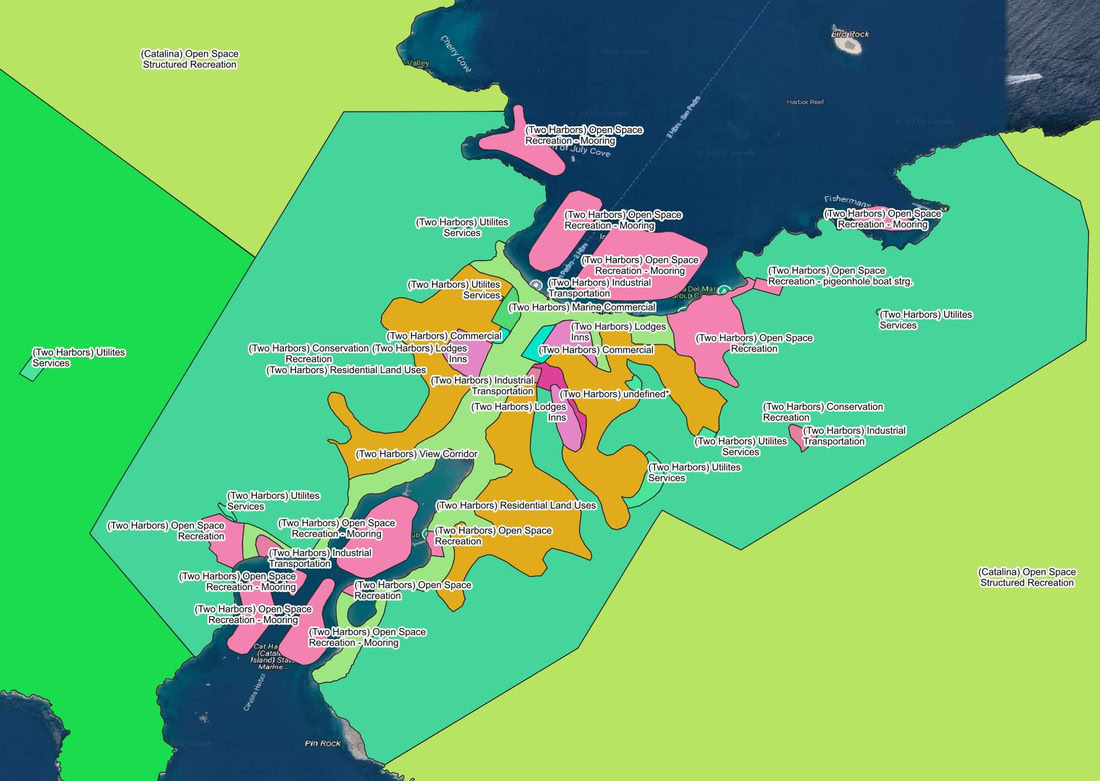
Catalina's Land_Use Policy Isthmus Map
Understanding Catalina's Land Use Policy Areas
The maps above show the official zoning and land use designations established by the Los Angeles County Local Coastal Program (LCP) and the Santa Catalina Island Specific Plan. Because Catalina is so unique, it has its own specialized zoning codes separate from mainland Los Angeles to balance conservation, tourism, and infrastructure.
Here is a breakdown of what each of these policy areas actually means on the ground.
Island-Wide (Catalina) Designations
(Catalina) Conservation / Primitive Recreation
What it is: This covers the vast majority of the island (the bright green on the map), primarily the land held by the Catalina Island Conservancy.
What is allowed: It is designated for the preservation of natural resources and habitats. Development is strictly limited to unpaved hiking trails, dirt roads, and primitive campsites (like Parsons Landing) that require packing in and packing out. No commercial, industrial, or structured residential development is allowed here.
(Catalina) Open Space / Structured Recreation
What it is: The lighter green areas on the map. This zoning is for areas that are still largely open space but allow for more intense human use and built recreational facilities.
What is allowed: This is the zoning that legally permits the existence of the historic youth camps (like Camp Emerald Bay or Catalina Island Camps), yacht club outstations, developed campgrounds (like Hermit Gulch or Little Harbor), and golf courses. It allows for dining halls, cabins, and sports courts to be built within a natural setting.
(Catalina) Industrial / Transportation / Utilities
What it is: The necessary infrastructure zones (shown in gray or localized pockets).
What is allowed: This covers the Airport in the Sky, the Southern California Edison power generation plant at Pebbly Beach, water desalination plants, sewage treatment facilities, and the heavy barge landing sites required to keep the island running.
Two Harbors (The Isthmus) Specific Designations
Because Two Harbors is a concentrated hub of activity, its zoning is micro-managed into smaller, highly specific parcels to control the tourist and boater footprint.
(Two Harbors) Open Space Recreation - Mooring
What it is: The pink areas over the water in the zoomed-in map.
What is allowed: This designates the exact coastal footprints where recreational boat moorings can legally be placed, managed, and rented out by SCICo in Isthmus Cove, Catalina Harbor, Cherry Cove, and Fourth of July Cove.
(Two Harbors) Commercial & Lodges / Inns
What it is: The orange and bright pink land parcels in the center of the Isthmus.
What is allowed: "Commercial" covers the visitor-serving businesses like the Harbor Reef Restaurant, the dive shop, and the general store. The "Lodges / Inns" designation allows for the Historic Banning House Lodge and the rental cabins on the hill.
(Two Harbors) Residential Land Uses
What it is: Small pockets designated strictly for housing.
What is allowed: Because you cannot commute to Two Harbors easily, these areas are zoned to allow housing for the year-round residents and seasonal employees who keep the Isthmus operating.
(Two Harbors) View Corridor
What it is: A very specific, protected zoning swath cutting across the center of the Isthmus.
What is allowed: Nothing that blocks the view. The Coastal Commission requires that the visual connection between the ocean at Isthmus Cove and the ocean at Catalina Harbor remains unobstructed. No large buildings or solid walls can be built here, ensuring the geographical "two harbors" feel is preserved for the public.
(Two Harbors) Industrial Transportation & Utilities Services
What it is: The working waterfront and back-of-house areas.
What is allowed: The main pier, the fuel docks, the barge landing for supply drop-offs, and the localized power, water, and sewage facilities strictly necessary to support the Isthmus population and visiting boaters.
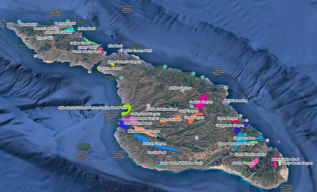
Catalina Island's SEA Regions Map
Map Data Sources: Los Angeles County GIS Department, NOAA, California State Geoportal, scag.ca.gov