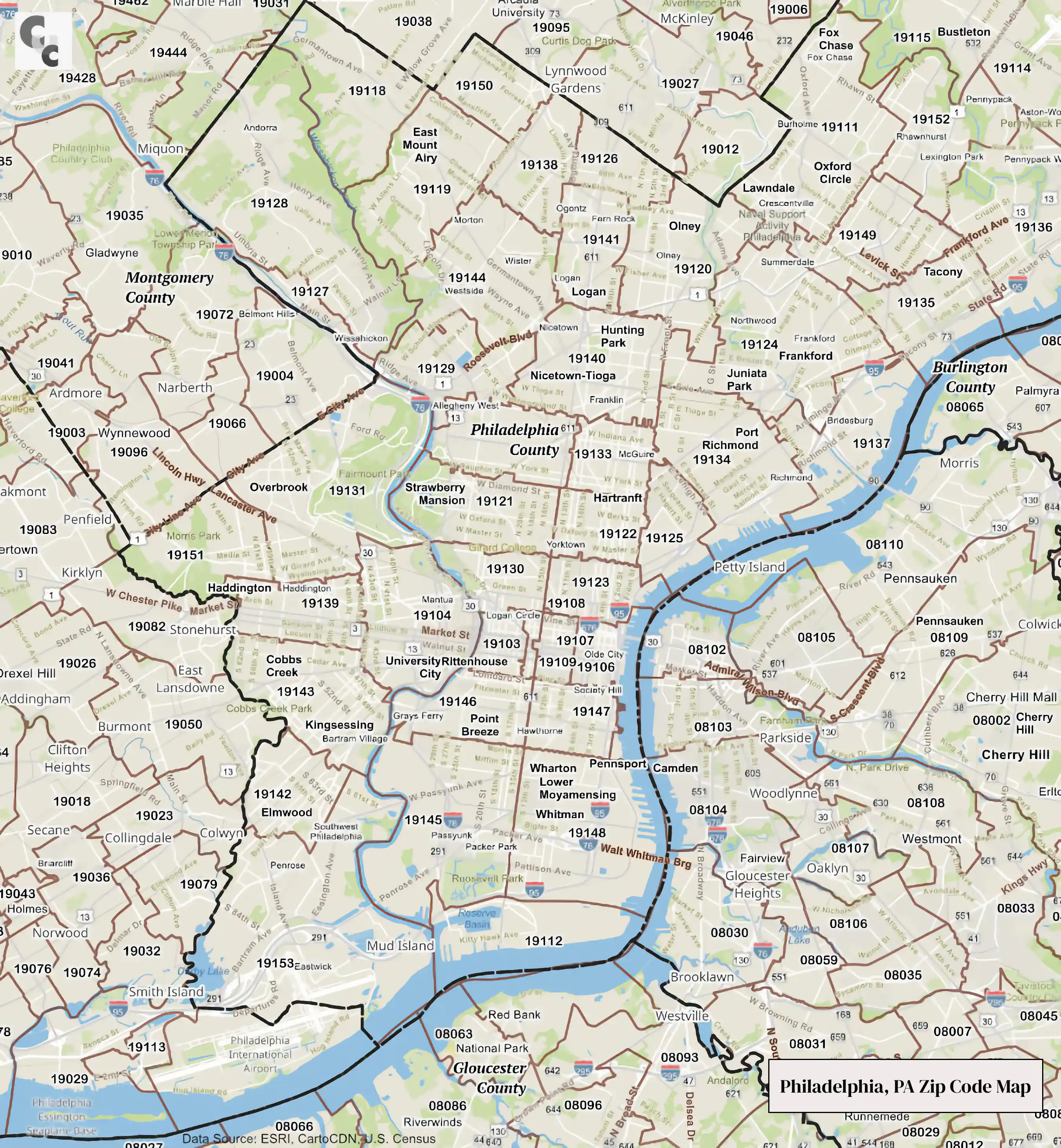
 Philadelphia Zip Codes Map
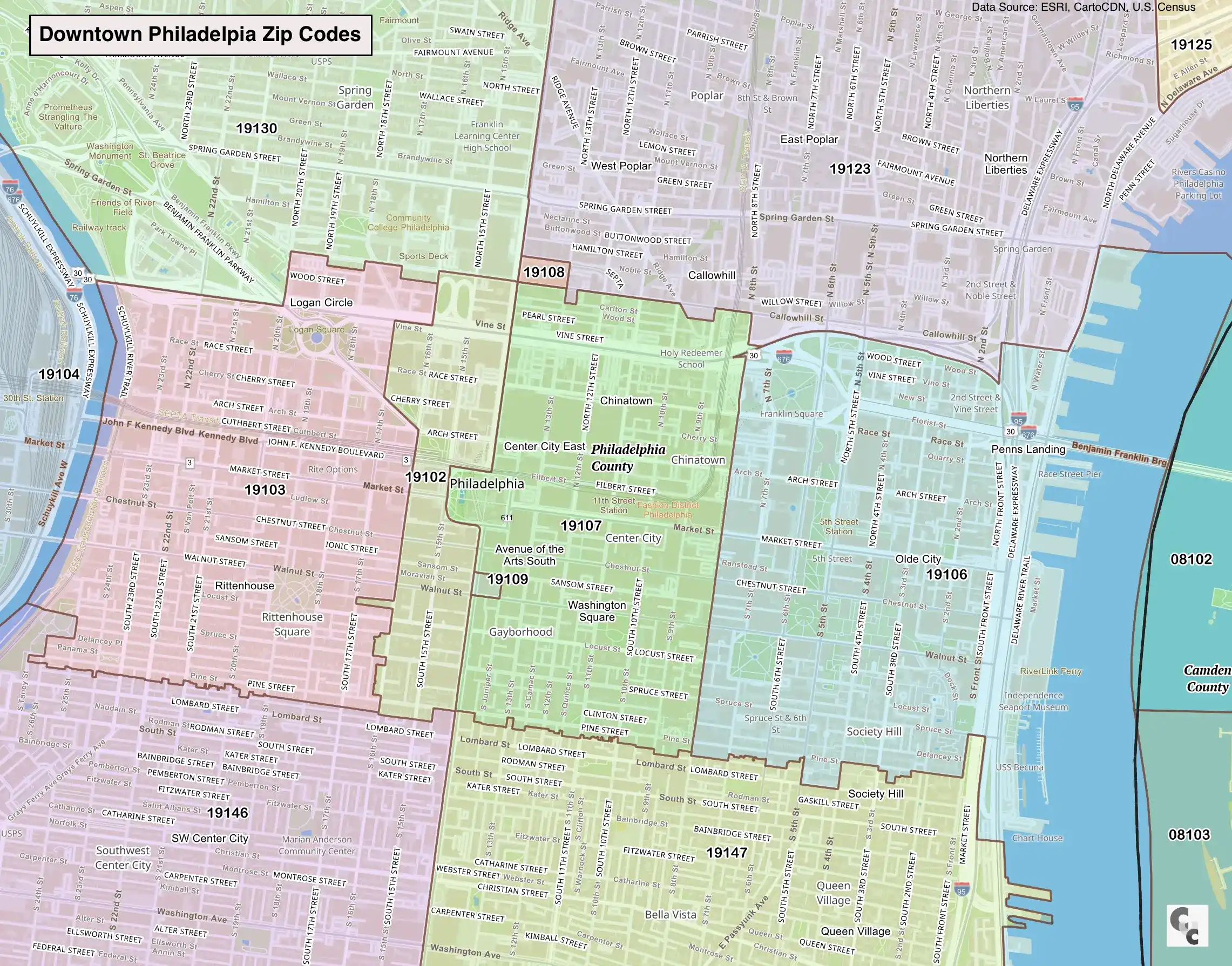 Downtown Philadelphia Zip Code Map
Philadelphia, PA Zip Code Map
Overview of Philadelphia County ZIP Codes
Philadelphia County, Pennsylvania, which is coterminous with the City of Philadelphia, features a dense and complex ZIP Code system covering historic rowhouse neighborhoods, modern skyscrapers, and industrial riverfronts.
The county includes 87 total ZIP Codes, comprised of standard residential delivery areas, extensive PO Box distribution centers, and unique codes for major institutions like UPenn and the federal government.
- Total ZIP Codes: 87
- Standard residential ZIP Codes: 48
- PO Box ZIP Codes: 29
- Unique / business ZIP Codes: 10 (e.g., City Hall, IRS, Naval Yard)
- Census ZIP Code Tabulation Areas (ZCTAs): 48
ZIP Code Range in Philadelphia County
Philadelphia County ZIP Codes fall exclusively within the "191" prefix range:
- Lowest ZIP Code: 19101 (General Post Office - PO Box)
- Lowest Residential ZIP Code: 19102 (Center City West)
- Highest ZIP Code: 19197 (Bny Mellon / Business)
- Highest Residential ZIP Code: 19154 (Northeast Philadelphia)
- Overall ZIP range: 19101–19197
Post Offices and PO Box ZIP Codes
- PO Box ZIP Codes: 29 PO Box-only ZIP Codes (e.g., 19101, 19105, 19108)
- Post office facilities: 56 USPS post offices, stations, and branches throughout the city
- PO Box locations: Concentrated in Center City (1910x series) and regional hubs like William Penn Annex
Cities, Towns, and Communities Covered by Philadelphia County ZIP Codes
Philadelphia County ZIP Codes serve the City of Philadelphia and its many neighborhoods and planning districts.
Major Urban Areas and Districts
- Center City Philadelphia
- North Philadelphia
- South Philadelphia
- West Philadelphia
- Northeast Philadelphia
- Northwest Philadelphia
Notable Communities and Neighborhoods
- Old City, Society Hill, Rittenhouse Square, University City
- Fishtown, Kensington, Port Richmond, Fairmount
- Germantown, Chestnut Hill, Roxborough, Manayunk
- Frankford, Tacony, Bustleton, Somerton
ZIP Codes often align closely with neighborhood boundaries; for example, 19147 covers Queen Village and Bella Vista, while 19118 is distinctly Chestnut Hill.
ZIP Code Population Patterns
Population density in Philadelphia County ZIP Codes ranges from extremely dense urban neighborhoods in Center City and North Philadelphia to lower-density residential areas in the Northeast.
- Most populated ZIP Code areas: The Northeast's 19120 (Olney/Feltonville) is the most populous, exceeding 73,000 residents, followed by 19124 (Frankford) and 19143 (West Philly).
- Least populated ZIP Codes: Unique codes like 19112 (Navy Yard) and downtown business codes (19102) have significantly lower residential populations.
Philadelphia County has a population exceeding 1.55 million residents, making it the sixth-most populous city in the United States.
Key ZIP Code Statistics (Summary)
| Category |
Value |
| Total ZIP Codes |
87 |
| Standard ZIP Codes |
48 |
| PO Box ZIP Codes |
29 |
| Unique / Business ZIP Codes |
10 |
| ZIP Code Range |
19101–19197 |
| Census ZCTAs |
48 |
| Highest Life Expectancy (by ZCTA) |
82.4 years (19106 - Old City/Society Hill) |
| Highest Crime Rate Index |
19134 (Kensington/Port Richmond)* |
*Note: 19134 (Kensington) consistently reports the highest volume of total incidents due to the open-air drug market crisis; 19140 (North Philly) typically reports high violent crime rates per capita.
Philadelphia County zip codes sorted by Neighborhood, City/Town, Zip Code and County.
- Academy Gardens Neighborhood Philadelphia City, Philadelphia County, PA 19114
- Academy Gardens Neighborhood Philadelphia City, Philadelphia County, PA 19136
- Airport Neighborhood Philadelphia City, Philadelphia County, PA 19112
- Airport Neighborhood Philadelphia City, Philadelphia County, PA 19153
- Allegheny West Neighborhood Philadelphia City, Philadelphia County, PA 19129
- Allegheny West Neighborhood Philadelphia City, Philadelphia County, PA 19131
- Allegheny West Neighborhood Philadelphia City, Philadelphia County, PA 19132
- Allegheny West Neighborhood Philadelphia City, Philadelphia County, PA 19140
- Allegheny West Neighborhood Philadelphia City, Philadelphia County, PA 19144
- Andorra Neighborhood Philadelphia City, Philadelphia County, PA 19118
- Andorra Neighborhood Philadelphia City, Philadelphia County, PA 19128
- Aston Woodbridge Neighborhood Philadelphia City, Philadelphia County, PA 19114
- Aston Woodbridge Neighborhood Philadelphia City, Philadelphia County, PA 19136
- Bartram Village Neighborhood Philadelphia City, Philadelphia County, PA 19104
- Bartram Village Neighborhood Philadelphia City, Philadelphia County, PA 19142
- Bartram Village Neighborhood Philadelphia City, Philadelphia County, PA 19143
- Bartram Village Neighborhood Philadelphia City, Philadelphia County, PA 19145
- Bartram Village Neighborhood Philadelphia City, Philadelphia County, PA 19146
- Bartram Village Neighborhood Philadelphia City, Philadelphia County, PA 19153
- Bella Vista Neighborhood Philadelphia City, Philadelphia County, PA 19147
- Belmont Neighborhood Philadelphia City, Philadelphia County, PA 19104
- Brewerytown Neighborhood Philadelphia City, Philadelphia County, PA 19121
- Brewerytown Neighborhood Philadelphia City, Philadelphia County, PA 19130
- Bridesburg Neighborhood Philadelphia City, Philadelphia County, PA 19124
- Bridesburg Neighborhood Philadelphia City, Philadelphia County, PA 19137
- Burnholme Neighborhood Philadelphia City, Philadelphia County, PA 19111
- Bustleton Neighborhood Philadelphia City, Philadelphia County, PA 19114
- Bustleton Neighborhood Philadelphia City, Philadelphia County, PA 19115
- Bustleton Neighborhood Philadelphia City, Philadelphia County, PA 19116
- Bustleton Neighborhood Philadelphia City, Philadelphia County, PA 19152
- Bustleton Neighborhood Philadelphia City, Philadelphia County, PA 19154
- Byberry Neighborhood Philadelphia City, Philadelphia County, PA 19116
- Byberry Neighborhood Philadelphia City, Philadelphia County, PA 19154
- Callow Hill Neighborhood Philadelphia City, Philadelphia County, PA 19102
- Callow Hill Neighborhood Philadelphia City, Philadelphia County, PA 19106
- Callow Hill Neighborhood Philadelphia City, Philadelphia County, PA 19107
- Callow Hill Neighborhood Philadelphia City, Philadelphia County, PA 19108
- Callow Hill Neighborhood Philadelphia City, Philadelphia County, PA 19123
- Callow Hill Neighborhood Philadelphia City, Philadelphia County, PA 19130
- Carroll Park Neighborhood Philadelphia City, Philadelphia County, PA 19131
- Carroll Park Neighborhood Philadelphia City, Philadelphia County, PA 19151
- Cedar Park Neighborhood Philadelphia City, Philadelphia County, PA 19143
- Cedarbrook Neighborhood Philadelphia City, Philadelphia County, PA 19119
- Cedarbrook Neighborhood Philadelphia City, Philadelphia County, PA 19150
- Center City Neighborhood Philadelphia City, Philadelphia County, PA 19102
- Center City Neighborhood Philadelphia City, Philadelphia County, PA 19107
- Chestnut Hill Neighborhood Philadelphia City, Philadelphia County, PA 19118
- Chinatown Neighborhood Philadelphia City, Philadelphia County, PA 19107
- Clearview Neighborhood Philadelphia City, Philadelphia County, PA 19142
- Clearview Neighborhood Philadelphia City, Philadelphia County, PA 19153
- Cobbs Creek Neighborhood Philadelphia City, Philadelphia County, PA 19139
- Cobbs Creek Neighborhood Philadelphia City, Philadelphia County, PA 19143
- Cobbs Creek Neighborhood Philadelphia City, Philadelphia County, PA 19151
- Crescentville Neighborhood Philadelphia City, Philadelphia County, PA 19111
- Crescentville Neighborhood Philadelphia City, Philadelphia County, PA 19120
- Crescentville Neighborhood Philadelphia City, Philadelphia County, PA 19124
- Crescentville Neighborhood Philadelphia City, Philadelphia County, PA 19149
- Crestmont Farms Neighborhood Philadelphia City, Philadelphia County, PA 19114
- Crestmont Farms Neighborhood Philadelphia City, Philadelphia County, PA 19154
- Dearnley Park Neighborhood Philadelphia City, Philadelphia County, PA 19127
- Dearnley Park Neighborhood Philadelphia City, Philadelphia County, PA 19128
- Dickinson Narrows Neighborhood Philadelphia City, Philadelphia County, PA 19147
- Dickinson Narrows Neighborhood Philadelphia City, Philadelphia County, PA 19148
- Dunlap Neighborhood Philadelphia City, Philadelphia County, PA 19139
- East Falls Neighborhood Philadelphia City, Philadelphia County, PA 19129
- East Falls Neighborhood Philadelphia City, Philadelphia County, PA 19131
- East Falls Neighborhood Philadelphia City, Philadelphia County, PA 19144
- East Kensington Neighborhood Philadelphia City, Philadelphia County, PA 19122
- East Kensington Neighborhood Philadelphia City, Philadelphia County, PA 19125
- East Kensington Neighborhood Philadelphia City, Philadelphia County, PA 19133
- East Oak Lane Neighborhood Philadelphia City, Philadelphia County, PA 19120
- East Oak Lane Neighborhood Philadelphia City, Philadelphia County, PA 19126
- East Oak Lane Neighborhood Philadelphia City, Philadelphia County, PA 19141
- East Park Neighborhood Philadelphia City, Philadelphia County, PA 19104
- East Park Neighborhood Philadelphia City, Philadelphia County, PA 19121
- East Park Neighborhood Philadelphia City, Philadelphia County, PA 19129
- East Park Neighborhood Philadelphia City, Philadelphia County, PA 19130
- East Park Neighborhood Philadelphia City, Philadelphia County, PA 19131
- East Park Neighborhood Philadelphia City, Philadelphia County, PA 19132
- East Parkside Neighborhood Philadelphia City, Philadelphia County, PA 19104
- East Parkside Neighborhood Philadelphia City, Philadelphia County, PA 19131
- East Passyunk Neighborhood Philadelphia City, Philadelphia County, PA 19147
- East Passyunk Neighborhood Philadelphia City, Philadelphia County, PA 19148
- East Poplar Neighborhood Philadelphia City, Philadelphia County, PA 19122
- East Poplar Neighborhood Philadelphia City, Philadelphia County, PA 19123
- Eastwick Neighborhood Philadelphia City, Philadelphia County, PA 19142
- Eastwick Neighborhood Philadelphia City, Philadelphia County, PA 19153
- Elmwood Neighborhood Philadelphia City, Philadelphia County, PA 19142
- Elmwood Neighborhood Philadelphia City, Philadelphia County, PA 19143
- Elmwood Neighborhood Philadelphia City, Philadelphia County, PA 19153
- Fairhill Neighborhood Philadelphia City, Philadelphia County, PA 19133
- Fairhill Neighborhood Philadelphia City, Philadelphia County, PA 19140
- Fairmount Neighborhood Philadelphia City, Philadelphia County, PA 19121
- Fairmount Neighborhood Philadelphia City, Philadelphia County, PA 19130
- Feltonville Neighborhood Philadelphia City, Philadelphia County, PA 19120
- Feltonville Neighborhood Philadelphia City, Philadelphia County, PA 19124
- Feltonville Neighborhood Philadelphia City, Philadelphia County, PA 19140
- Fern Rock Neighborhood Philadelphia City, Philadelphia County, PA 19120
- Fern Rock Neighborhood Philadelphia City, Philadelphia County, PA 19126
- Fern Rock Neighborhood Philadelphia City, Philadelphia County, PA 19141
- Fishtown Neighborhood Philadelphia City, Philadelphia County, PA 19122
- Fishtown Neighborhood Philadelphia City, Philadelphia County, PA 19123
- Fishtown Neighborhood Philadelphia City, Philadelphia County, PA 19125
- Fishtown Neighborhood Philadelphia City, Philadelphia County, PA 19134
- Fitler Square Neighborhood Philadelphia City, Philadelphia County, PA 19103
- Fitler Square Neighborhood Philadelphia City, Philadelphia County, PA 19104
- Fitler Square Neighborhood Philadelphia City, Philadelphia County, PA 19146
- Fox Chase Neighborhood Philadelphia City, Philadelphia County, PA 19111
- Fox Chase Neighborhood Philadelphia City, Philadelphia County, PA 19115
- Francisville Neighborhood Philadelphia City, Philadelphia County, PA 19121
- Francisville Neighborhood Philadelphia City, Philadelphia County, PA 19122
- Francisville Neighborhood Philadelphia City, Philadelphia County, PA 19123
- Francisville Neighborhood Philadelphia City, Philadelphia County, PA 19130
- Frankford Neighborhood Philadelphia City, Philadelphia County, PA 19124
- Frankford Neighborhood Philadelphia City, Philadelphia County, PA 19137
- Franklin Mills Neighborhood Philadelphia City, Philadelphia County, PA 19154
- Franklinville Neighborhood Philadelphia City, Philadelphia County, PA 19132
- Franklinville Neighborhood Philadelphia City, Philadelphia County, PA 19133
- Franklinville Neighborhood Philadelphia City, Philadelphia County, PA 19140
- Garden Court Neighborhood Philadelphia City, Philadelphia County, PA 19139
- Garden Court Neighborhood Philadelphia City, Philadelphia County, PA 19143
- Germantown East Neighborhood Philadelphia City, Philadelphia County, PA 19138
- Germantown East Neighborhood Philadelphia City, Philadelphia County, PA 19144
- Germantown Morton Neighborhood Philadelphia City, Philadelphia County, PA 19138
- Germantown Morton Neighborhood Philadelphia City, Philadelphia County, PA 19144
- Germantown Penn Knox Neighborhood Philadelphia City, Philadelphia County, PA 19144
- Germantown Southwest Neighborhood Philadelphia City, Philadelphia County, PA 19144
- Germantown West Central Neighborhood Philadelphia City, Philadelphia County, PA 19119
- Germantown West Central Neighborhood Philadelphia City, Philadelphia County, PA 19144
- Germantown Westside Neighborhood Philadelphia City, Philadelphia County, PA 19129
- Germantown Westside Neighborhood Philadelphia City, Philadelphia County, PA 19144
- Germany Hill Neighborhood Philadelphia City, Philadelphia County, PA 19127
- Germany Hill Neighborhood Philadelphia City, Philadelphia County, PA 19128
- Girard Estates Neighborhood Philadelphia City, Philadelphia County, PA 19145
- Girard Estates Neighborhood Philadelphia City, Philadelphia County, PA 19148
- Glenwood Neighborhood Philadelphia City, Philadelphia County, PA 19132
- Glenwood Neighborhood Philadelphia City, Philadelphia County, PA 19140
- Graduate Hospital Neighborhood Philadelphia City, Philadelphia County, PA 19104
- Graduate Hospital Neighborhood Philadelphia City, Philadelphia County, PA 19146
- Grays Ferry Neighborhood Philadelphia City, Philadelphia County, PA 19104
- Grays Ferry Neighborhood Philadelphia City, Philadelphia County, PA 19143
- Grays Ferry Neighborhood Philadelphia City, Philadelphia County, PA 19145
- Grays Ferry Neighborhood Philadelphia City, Philadelphia County, PA 19146
- Greenwich Neighborhood Philadelphia City, Philadelphia County, PA 19148
- Haddington Neighborhood Philadelphia City, Philadelphia County, PA 19131
- Haddington Neighborhood Philadelphia City, Philadelphia County, PA 19139
- Haddington Neighborhood Philadelphia City, Philadelphia County, PA 19151
- Harrowgate Neighborhood Philadelphia City, Philadelphia County, PA 19124
- Harrowgate Neighborhood Philadelphia City, Philadelphia County, PA 19134
- Harrowgate Neighborhood Philadelphia City, Philadelphia County, PA 19137
- Hartranft Neighborhood Philadelphia City, Philadelphia County, PA 19122
- Hartranft Neighborhood Philadelphia City, Philadelphia County, PA 19132
- Hartranft Neighborhood Philadelphia City, Philadelphia County, PA 19133
- Hartranft Neighborhood Philadelphia City, Philadelphia County, PA 19140
- Haverford North Neighborhood Philadelphia City, Philadelphia County, PA 19104
- Hawthorne Neighborhood Philadelphia City, Philadelphia County, PA 19146
- Hawthorne Neighborhood Philadelphia City, Philadelphia County, PA 19147
- Holmesburg Neighborhood Philadelphia City, Philadelphia County, PA 19135
- Holmesburg Neighborhood Philadelphia City, Philadelphia County, PA 19136
- Hunting Park Neighborhood Philadelphia City, Philadelphia County, PA 19120
- Hunting Park Neighborhood Philadelphia City, Philadelphia County, PA 19124
- Hunting Park Neighborhood Philadelphia City, Philadelphia County, PA 19134
- Hunting Park Neighborhood Philadelphia City, Philadelphia County, PA 19140
- Industrial Neighborhood Philadelphia City, Philadelphia County, PA 19112
- Industrial Neighborhood Philadelphia City, Philadelphia County, PA 19142
- Industrial Neighborhood Philadelphia City, Philadelphia County, PA 19143
- Industrial Neighborhood Philadelphia City, Philadelphia County, PA 19145
- Industrial Neighborhood Philadelphia City, Philadelphia County, PA 19153
- Juniata Park Neighborhood Philadelphia City, Philadelphia County, PA 19120
- Juniata Park Neighborhood Philadelphia City, Philadelphia County, PA 19124
- Juniata Park Neighborhood Philadelphia City, Philadelphia County, PA 19134
- Kingesessing Neighborhood Philadelphia City, Philadelphia County, PA 19142
- Kingesessing Neighborhood Philadelphia City, Philadelphia County, PA 19143
- Lawndale Neighborhood Philadelphia City, Philadelphia County, PA 19111
- Lawndale Neighborhood Philadelphia City, Philadelphia County, PA 19120
- Lawndale Neighborhood Philadelphia City, Philadelphia County, PA 19124
- Lexington Park Neighborhood Philadelphia City, Philadelphia County, PA 19136
- Lexington Park Neighborhood Philadelphia City, Philadelphia County, PA 19152
- Logan Neighborhood Philadelphia City, Philadelphia County, PA 19120
- Logan Neighborhood Philadelphia City, Philadelphia County, PA 19140
- Logan Neighborhood Philadelphia City, Philadelphia County, PA 19141
- Logan Neighborhood Philadelphia City, Philadelphia County, PA 19144
- Logan Square Neighborhood Philadelphia City, Philadelphia County, PA 19102
- Logan Square Neighborhood Philadelphia City, Philadelphia County, PA 19103
- Logan Square Neighborhood Philadelphia City, Philadelphia County, PA 19104
- Logan Square Neighborhood Philadelphia City, Philadelphia County, PA 19107
- Logan Square Neighborhood Philadelphia City, Philadelphia County, PA 19130
- Lower Moyamensing Neighborhood Philadelphia City, Philadelphia County, PA 19148
- Ludlow Neighborhood Philadelphia City, Philadelphia County, PA 19122
- Ludlow Neighborhood Philadelphia City, Philadelphia County, PA 19123
- Manayunk Neighborhood Philadelphia City, Philadelphia County, PA 19127
- Manayunk Neighborhood Philadelphia City, Philadelphia County, PA 19128
- Mantua Neighborhood Philadelphia City, Philadelphia County, PA 19104
- Mantua Neighborhood Philadelphia City, Philadelphia County, PA 19130
- Mayfair Neighborhood Philadelphia City, Philadelphia County, PA 19124
- Mayfair Neighborhood Philadelphia City, Philadelphia County, PA 19135
- Mayfair Neighborhood Philadelphia City, Philadelphia County, PA 19136
- Mayfair Neighborhood Philadelphia City, Philadelphia County, PA 19149
- Mayfair Neighborhood Philadelphia City, Philadelphia County, PA 19152
- McGuire Neighborhood Philadelphia City, Philadelphia County, PA 19125
- McGuire Neighborhood Philadelphia City, Philadelphia County, PA 19133
- McGuire Neighborhood Philadelphia City, Philadelphia County, PA 19134
- Mechanicsville Neighborhood Philadelphia City, Philadelphia County, PA 19154
- Melrose Park Gardens Neighborhood Philadelphia City, Philadelphia County, PA 19120
- Melrose Park Gardens Neighborhood Philadelphia City, Philadelphia County, PA 19126
- Mill Creek Neighborhood Philadelphia City, Philadelphia County, PA 19104
- Mill Creek Neighborhood Philadelphia City, Philadelphia County, PA 19131
- Mill Creek Neighborhood Philadelphia City, Philadelphia County, PA 19139
- Millbrook Neighborhood Philadelphia City, Philadelphia County, PA 19154
- Modena Neighborhood Philadelphia City, Philadelphia County, PA 19114
- Modena Neighborhood Philadelphia City, Philadelphia County, PA 19154
- Morrell Park Neighborhood Philadelphia City, Philadelphia County, PA 19114
- Morrell Park Neighborhood Philadelphia City, Philadelphia County, PA 19154
- Mount Airy East Neighborhood Philadelphia City, Philadelphia County, PA 19118
- Mount Airy East Neighborhood Philadelphia City, Philadelphia County, PA 19119
- Mount Airy East Neighborhood Philadelphia City, Philadelphia County, PA 19138
- Mount Airy East Neighborhood Philadelphia City, Philadelphia County, PA 19144
- Mount Airy East Neighborhood Philadelphia City, Philadelphia County, PA 19150
- Mount Airy West Neighborhood Philadelphia City, Philadelphia County, PA 19118
- Mount Airy West Neighborhood Philadelphia City, Philadelphia County, PA 19119
- Mount Airy West Neighborhood Philadelphia City, Philadelphia County, PA 19144
- Navy Yard Neighborhood Philadelphia City, Philadelphia County, PA 19112
- Navy Yard Neighborhood Philadelphia City, Philadelphia County, PA 19145
- Navy Yard Neighborhood Philadelphia City, Philadelphia County, PA 19153
- Newbold Neighborhood Philadelphia City, Philadelphia County, PA 19145
- Newbold Neighborhood Philadelphia City, Philadelphia County, PA 19146
- Newbold Neighborhood Philadelphia City, Philadelphia County, PA 19147
- Newbold Neighborhood Philadelphia City, Philadelphia County, PA 19148
- Nicetown Neighborhood Philadelphia City, Philadelphia County, PA 19129
- Nicetown Neighborhood Philadelphia City, Philadelphia County, PA 19140
- Nicetown Neighborhood Philadelphia City, Philadelphia County, PA 19144
- Normandy Village Neighborhood Philadelphia City, Philadelphia County, PA 19116
- Normandy Village Neighborhood Philadelphia City, Philadelphia County, PA 19154
- North Central Neighborhood Philadelphia City, Philadelphia County, PA 19121
- North Central Neighborhood Philadelphia City, Philadelphia County, PA 19122
- North Central Neighborhood Philadelphia City, Philadelphia County, PA 19130
- Northeast Airport Neighborhood Philadelphia City, Philadelphia County, PA 19114
- Northeast Airport Neighborhood Philadelphia City, Philadelphia County, PA 19115
- Northeast Airport Neighborhood Philadelphia City, Philadelphia County, PA 19116
- Northeast Airport Neighborhood Philadelphia City, Philadelphia County, PA 19154
- Northern Liberties Neighborhood Philadelphia City, Philadelphia County, PA 19106
- Northern Liberties Neighborhood Philadelphia City, Philadelphia County, PA 19122
- Northern Liberties Neighborhood Philadelphia City, Philadelphia County, PA 19123
- Northern Liberties Neighborhood Philadelphia City, Philadelphia County, PA 19125
- Northwood Neighborhood Philadelphia City, Philadelphia County, PA 19120
- Northwood Neighborhood Philadelphia City, Philadelphia County, PA 19124
- Ogontz Neighborhood Philadelphia City, Philadelphia County, PA 19126
- Ogontz Neighborhood Philadelphia City, Philadelphia County, PA 19138
- Ogontz Neighborhood Philadelphia City, Philadelphia County, PA 19141
- Ogontz Neighborhood Philadelphia City, Philadelphia County, PA 19144
- Old City Neighborhood Philadelphia City, Philadelphia County, PA 19106
- Old City Neighborhood Philadelphia City, Philadelphia County, PA 19107
- Old City Neighborhood Philadelphia City, Philadelphia County, PA 19123
- Old Kensington Neighborhood Philadelphia City, Philadelphia County, PA 19122
- Old Kensington Neighborhood Philadelphia City, Philadelphia County, PA 19123
- Olney Neighborhood Philadelphia City, Philadelphia County, PA 19120
- Olney Neighborhood Philadelphia City, Philadelphia County, PA 19124
- Olney Neighborhood Philadelphia City, Philadelphia County, PA 19126
- Olney Neighborhood Philadelphia City, Philadelphia County, PA 19140
- Olney Neighborhood Philadelphia City, Philadelphia County, PA 19141
- Overbrook Neighborhood Philadelphia City, Philadelphia County, PA 19131
- Overbrook Neighborhood Philadelphia City, Philadelphia County, PA 19139
- Overbrook Neighborhood Philadelphia City, Philadelphia County, PA 19151
- Oxford Circle Neighborhood Philadelphia City, Philadelphia County, PA 19111
- Oxford Circle Neighborhood Philadelphia City, Philadelphia County, PA 19124
- Oxford Circle Neighborhood Philadelphia City, Philadelphia County, PA 19149
- Oxford Circle Neighborhood Philadelphia City, Philadelphia County, PA 19152
- Packer Park Neighborhood Philadelphia City, Philadelphia County, PA 19145
- Packer Park Neighborhood Philadelphia City, Philadelphia County, PA 19148
- Parkwood Manor Neighborhood Philadelphia City, Philadelphia County, PA 19154
- Paschall Neighborhood Philadelphia City, Philadelphia County, PA 19142
- Paschall Neighborhood Philadelphia City, Philadelphia County, PA 19143
- Passyunk Square Neighborhood Philadelphia City, Philadelphia County, PA 19146
- Passyunk Square Neighborhood Philadelphia City, Philadelphia County, PA 19147
- Passyunk Square Neighborhood Philadelphia City, Philadelphia County, PA 19148
- Pennsport Neighborhood Philadelphia City, Philadelphia County, PA 19147
- Pennsport Neighborhood Philadelphia City, Philadelphia County, PA 19148
- Pennypack Neighborhood Philadelphia City, Philadelphia County, PA 19114
- Pennypack Neighborhood Philadelphia City, Philadelphia County, PA 19115
- Pennypack Neighborhood Philadelphia City, Philadelphia County, PA 19136
- Pennypack Neighborhood Philadelphia City, Philadelphia County, PA 19152
- Pennypack Park Neighborhood Philadelphia City, Philadelphia County, PA 19111
- Pennypack Park Neighborhood Philadelphia City, Philadelphia County, PA 19115
- Pennypack Park Neighborhood Philadelphia City, Philadelphia County, PA 19136
- Pennypack Park Neighborhood Philadelphia City, Philadelphia County, PA 19152
- Pennypack Woods Neighborhood Philadelphia City, Philadelphia County, PA 19114
- Pennypack Woods Neighborhood Philadelphia City, Philadelphia County, PA 19136
- Pennypack Woods Neighborhood Philadelphia City, Philadelphia County, PA 19152
- Penrose Neighborhood Philadelphia City, Philadelphia County, PA 19142
- Penrose Neighborhood Philadelphia City, Philadelphia County, PA 19153
- Point Breeze Neighborhood Philadelphia City, Philadelphia County, PA 19145
- Point Breeze Neighborhood Philadelphia City, Philadelphia County, PA 19146
- Point Breeze Neighborhood Philadelphia City, Philadelphia County, PA 19147
- Port Richmond Neighborhood Philadelphia City, Philadelphia County, PA 19125
- Port Richmond Neighborhood Philadelphia City, Philadelphia County, PA 19134
- Powelton Neighborhood Philadelphia City, Philadelphia County, PA 19104
- Queen Village Neighborhood Philadelphia City, Philadelphia County, PA 19147
- Rhawnhurst Neighborhood Philadelphia City, Philadelphia County, PA 19111
- Rhawnhurst Neighborhood Philadelphia City, Philadelphia County, PA 19115
- Rhawnhurst Neighborhood Philadelphia City, Philadelphia County, PA 19149
- Rhawnhurst Neighborhood Philadelphia City, Philadelphia County, PA 19152
- Richmond Neighborhood Philadelphia City, Philadelphia County, PA 19125
- Richmond Neighborhood Philadelphia City, Philadelphia County, PA 19134
- Richmond Neighborhood Philadelphia City, Philadelphia County, PA 19137
- Rittenhouse Neighborhood Philadelphia City, Philadelphia County, PA 19102
- Rittenhouse Neighborhood Philadelphia City, Philadelphia County, PA 19103
- Rittenhouse Neighborhood Philadelphia City, Philadelphia County, PA 19104
- Rittenhouse Neighborhood Philadelphia City, Philadelphia County, PA 19107
- Rittenhouse Neighborhood Philadelphia City, Philadelphia County, PA 19146
- Riverfront Neighborhood Philadelphia City, Philadelphia County, PA 19106
- Riverfront Neighborhood Philadelphia City, Philadelphia County, PA 19112
- Riverfront Neighborhood Philadelphia City, Philadelphia County, PA 19123
- Riverfront Neighborhood Philadelphia City, Philadelphia County, PA 19147
- Riverfront Neighborhood Philadelphia City, Philadelphia County, PA 19148
- Roxborough Neighborhood Philadelphia City, Philadelphia County, PA 19127
- Roxborough Neighborhood Philadelphia City, Philadelphia County, PA 19128
- Roxborough Park Neighborhood Philadelphia City, Philadelphia County, PA 19127
- Roxborough Park Neighborhood Philadelphia City, Philadelphia County, PA 19128
- Sharswood Neighborhood Philadelphia City, Philadelphia County, PA 19121
- Sharswood Neighborhood Philadelphia City, Philadelphia County, PA 19130
- Society Hill Neighborhood Philadelphia City, Philadelphia County, PA 19106
- Society Hill Neighborhood Philadelphia City, Philadelphia County, PA 19147
- Somerton Neighborhood Philadelphia City, Philadelphia County, PA 19115
- Somerton Neighborhood Philadelphia City, Philadelphia County, PA 19116
- Somerton Neighborhood Philadelphia City, Philadelphia County, PA 19154
- Southwest Schuylkill Neighborhood Philadelphia City, Philadelphia County, PA 19104
- Southwest Schuylkill Neighborhood Philadelphia City, Philadelphia County, PA 19143
- Southwest Schuylkill Neighborhood Philadelphia City, Philadelphia County, PA 19146
- Spring Garden Neighborhood Philadelphia City, Philadelphia County, PA 19123
- Spring Garden Neighborhood Philadelphia City, Philadelphia County, PA 19130
- Spruce Hill Neighborhood Philadelphia City, Philadelphia County, PA 19104
- Spruce Hill Neighborhood Philadelphia City, Philadelphia County, PA 19139
- Spruce Hill Neighborhood Philadelphia City, Philadelphia County, PA 19143
- Stadium District Neighborhood Philadelphia City, Philadelphia County, PA 19112
- Stadium District Neighborhood Philadelphia City, Philadelphia County, PA 19145
- Stadium District Neighborhood Philadelphia City, Philadelphia County, PA 19148
- Stanton Neighborhood Philadelphia City, Philadelphia County, PA 19121
- Stanton Neighborhood Philadelphia City, Philadelphia County, PA 19122
- Stanton Neighborhood Philadelphia City, Philadelphia County, PA 19132
- Strawberry Mansion Neighborhood Philadelphia City, Philadelphia County, PA 19121
- Strawberry Mansion Neighborhood Philadelphia City, Philadelphia County, PA 19129
- Strawberry Mansion Neighborhood Philadelphia City, Philadelphia County, PA 19132
- Summerdale Neighborhood Philadelphia City, Philadelphia County, PA 19111
- Summerdale Neighborhood Philadelphia City, Philadelphia County, PA 19124
- Summerdale Neighborhood Philadelphia City, Philadelphia County, PA 19149
- Tacony Neighborhood Philadelphia City, Philadelphia County, PA 19135
- Tacony Neighborhood Philadelphia City, Philadelphia County, PA 19136
- Tacony Neighborhood Philadelphia City, Philadelphia County, PA 19149
- Tioga Neighborhood Philadelphia City, Philadelphia County, PA 19129
- Tioga Neighborhood Philadelphia City, Philadelphia County, PA 19132
- Tioga Neighborhood Philadelphia City, Philadelphia County, PA 19140
- Tioga Neighborhood Philadelphia City, Philadelphia County, PA 19144
- Torresdale Neighborhood Philadelphia City, Philadelphia County, PA 19114
- Torresdale Neighborhood Philadelphia City, Philadelphia County, PA 19136
- University City Neighborhood Philadelphia City, Philadelphia County, PA 19103
- University City Neighborhood Philadelphia City, Philadelphia County, PA 19104
- University City Neighborhood Philadelphia City, Philadelphia County, PA 19130
- University City Neighborhood Philadelphia City, Philadelphia County, PA 19146
- Upper Kensington Neighborhood Philadelphia City, Philadelphia County, PA 19125
- Upper Kensington Neighborhood Philadelphia City, Philadelphia County, PA 19133
- Upper Kensington Neighborhood Philadelphia City, Philadelphia County, PA 19134
- Upper Kensington Neighborhood Philadelphia City, Philadelphia County, PA 19140
- Upper Roxborough Neighborhood Philadelphia City, Philadelphia County, PA 19127
- Upper Roxborough Neighborhood Philadelphia City, Philadelphia County, PA 19128
- Walnut Hill Neighborhood Philadelphia City, Philadelphia County, PA 19104
- Walnut Hill Neighborhood Philadelphia City, Philadelphia County, PA 19139
- Walnut Hill Neighborhood Philadelphia City, Philadelphia County, PA 19143
- Washington Square Neighborhood Philadelphia City, Philadelphia County, PA 19102
- Washington Square Neighborhood Philadelphia City, Philadelphia County, PA 19106
- Washington Square Neighborhood Philadelphia City, Philadelphia County, PA 19107
- Washington Square Neighborhood Philadelphia City, Philadelphia County, PA 19109
- Washington Square Neighborhood Philadelphia City, Philadelphia County, PA 19146
- Washington Square Neighborhood Philadelphia City, Philadelphia County, PA 19147
- West Kensington Neighborhood Philadelphia City, Philadelphia County, PA 19122
- West Kensington Neighborhood Philadelphia City, Philadelphia County, PA 19125
- West Kensington Neighborhood Philadelphia City, Philadelphia County, PA 19133
- West Oak Lane Neighborhood Philadelphia City, Philadelphia County, PA 19119
- West Oak Lane Neighborhood Philadelphia City, Philadelphia County, PA 19126
- West Oak Lane Neighborhood Philadelphia City, Philadelphia County, PA 19138
- West Oak Lane Neighborhood Philadelphia City, Philadelphia County, PA 19141
- West Oak Lane Neighborhood Philadelphia City, Philadelphia County, PA 19150
- West Park Neighborhood Philadelphia City, Philadelphia County, PA 19104
- West Park Neighborhood Philadelphia City, Philadelphia County, PA 19121
- West Park Neighborhood Philadelphia City, Philadelphia County, PA 19130
- West Park Neighborhood Philadelphia City, Philadelphia County, PA 19131
- West Park Neighborhood Philadelphia City, Philadelphia County, PA 19132
- West Parkside Neighborhood Philadelphia City, Philadelphia County, PA 19104
- West Parkside Neighborhood Philadelphia City, Philadelphia County, PA 19131
- West Passyunk Neighborhood Philadelphia City, Philadelphia County, PA 19145
- West Poplar Neighborhood Philadelphia City, Philadelphia County, PA 19122
- West Poplar Neighborhood Philadelphia City, Philadelphia County, PA 19123
- West Powelton Neighborhood Philadelphia City, Philadelphia County, PA 19104
- West Powelton Neighborhood Philadelphia City, Philadelphia County, PA 19139
- West Torresdale Neighborhood Philadelphia City, Philadelphia County, PA 19114
- Whitman Neighborhood Philadelphia City, Philadelphia County, PA 19148
- Winchester Park Neighborhood Philadelphia City, Philadelphia County, PA 19136
- Winchester Park Neighborhood Philadelphia City, Philadelphia County, PA 19152
- Wissahickon Hills Neighborhood Philadelphia City, Philadelphia County, PA 19128
- Wissahickon Neighborhood Philadelphia City, Philadelphia County, PA 19127
- Wissahickon Neighborhood Philadelphia City, Philadelphia County, PA 19128
- Wissahickon Park Neighborhood Philadelphia City, Philadelphia County, PA 19118
- Wissahickon Park Neighborhood Philadelphia City, Philadelphia County, PA 19119
- Wissahickon Park Neighborhood Philadelphia City, Philadelphia County, PA 19127
- Wissahickon Park Neighborhood Philadelphia City, Philadelphia County, PA 19128
- Wissahickon Park Neighborhood Philadelphia City, Philadelphia County, PA 19129
- Wissahickon Park Neighborhood Philadelphia City, Philadelphia County, PA 19144
- Wissinoming Neighborhood Philadelphia City, Philadelphia County, PA 19124
- Wissinoming Neighborhood Philadelphia City, Philadelphia County, PA 19135
- Wissinoming Neighborhood Philadelphia City, Philadelphia County, PA 19137
- Wissinoming Neighborhood Philadelphia City, Philadelphia County, PA 19149
- Wister Neighborhood Philadelphia City, Philadelphia County, PA 19141
- Wister Neighborhood Philadelphia City, Philadelphia County, PA 19144
- Woodland Terrace Neighborhood Philadelphia City, Philadelphia County, PA 19104
- Wynnefield Heights Neighborhood Philadelphia City, Philadelphia County, PA 19131
- Wynnefield Neighborhood Philadelphia City, Philadelphia County, PA 19131
- Wynnefield Neighborhood Philadelphia City, Philadelphia County, PA 19151
- Yorktown Neighborhood Philadelphia City, Philadelphia County, PA 19122
- Yorktown Neighborhood Philadelphia City, Philadelphia County, PA 19123
POST OFFICE LOCATIONS
30TH STREET POST OFFICE — 2955 MARKET ST LBBY A, PHILADELPHIA, PA 19104-9775
FREE FRANKLIN POST OFFICE — 316 MARKET ST, PHILADELPHIA, PA 19106-9996
BOULEVARD POST OFFICE — 2801 LEVICK ST, PHILADELPHIA, PA 19149-9998
BRIDESBURG POST OFFICE — 2734 ORTHODOX ST, PHILADELPHIA, PA 19137-9998
BUSTLETON POST OFFICE — 9925 BUSTLETON AVE, PHILADELPHIA, PA 19115-9998
CASTLE POST OFFICE — 1713 S BROAD ST, PHILADELPHIA, PA 19148-9996
CASTOR POST OFFICE — 6382 CASTOR AVE, PHILADELPHIA, PA 19149-9997
CHESTNUT HILL POST OFFICE — 8225 GERMANTOWN AVE, PHILADELPHIA, PA 19118-9997
CONTINENTAL POST OFFICE — 615 CHESTNUT ST LBBY, PHILADELPHIA, PA 19106-9997
EAST FALLS POST OFFICE — 4130 RIDGE AVE, PHILADELPHIA, PA 19129-9998
EAST GERMANTOWN POST OFFICE — 2031 66TH AVE, PHILADELPHIA, PA 19138-9998
FAIRHILL POST OFFICE — 217 W LEHIGH AVE STE 2, PHILADELPHIA, PA 19133-9997
FAIRMOUNT POST OFFICE — 900 N 19TH ST, PHILADELPHIA, PA 19130-9998
FAIRMOUNT FINANCE POST OFFICE — 1939 FAIRMOUNT AVE, PHILADELPHIA, PA 19130-9997
FOX CHASE POST OFFICE — 7232 RISING SUN AVE, PHILADELPHIA, PA 19111-9998
FRANKFORD POST OFFICE — 4410 PAUL ST, PHILADELPHIA, PA 19124-9998
FRANKLIN MILLS POST OFFICE — 1735 FRANKLIN MILLS CIR, PHILADELPHIA, PA 19154-9997
GERMANTOWN POST OFFICE — 5209 GREENE ST STE 1, PHILADELPHIA, PA 19144-9998
HOLMESBURG POSTAL STORE POST OFFICE — 8232 FRANKFORD AVE STE A, PHILADELPHIA, PA 19136-9998
HUNTING PARK POST OFFICE — 4350 N FRONT ST, PHILADELPHIA, PA 19140-9995
JOHN WANAMAKER POST OFFICE — 1234 MARKET ST, PHILADELPHIA, PA 19107-9997
KENSINGTON POST OFFICE — 1602 FRANKFORD AVE, PHILADELPHIA, PA 19125-9998
KINGSESSING POST OFFICE — 5311 FLORENCE AVE, PHILADELPHIA, PA 19143-9998
LAND TITLE BLDG POST OFFICE — 100 S BROAD ST STE 30, PHILADELPHIA, PA 19110-9997
LOGAN POST OFFICE — 6150 N BROAD ST, PHILADELPHIA, PA 19141-9998
MANAYUNK POST OFFICE — 4431 MAIN ST, PHILADELPHIA, PA 19127-9998
MARKET SQUARE POST OFFICE — 7782 CRITTENDEN ST, PHILADELPHIA, PA 19118-9998
MAYFAIR POST OFFICE — 7303 FRANKFORD AVE, PHILADELPHIA, PA 19136-9996
MIDDLE CITY POST OFFICE — 2037 CHESTNUT ST FL 1, PHILADELPHIA, PA 19103-9997
MOUNT AIRY POSTAL STORE POST OFFICE — 6711 GERMANTOWN AVE, PHILADELPHIA, PA 19119-9997
NICETOWN FINANCE POST OFFICE — 3968 GERMANTOWN AVE, PHILADELPHIA, PA 19140-9998
NORTH PHILADELPHIA POST OFFICE — 2601 N 16TH ST, PHILADELPHIA, PA 19132-9998
NORWOOD POST OFFICE — 326 CHESTER PIKE, NORWOOD, PA 19074-9998
OLNEY RETAIL POST OFFICE — 101 E OLNEY AVE UNIT 330, PHILADELPHIA, PA 19120-9996
OVERBROOK POST OFFICE — 658 N 63RD ST, PHILADELPHIA, PA 19151-9998
PENN CENTER POST OFFICE — 1500 JOHN F KENNEDY BLVD STE C31, PHILADELPHIA, PA 19102-9997
PENNS LANDING POST OFFICE — 622 S 4TH ST STE 1, PHILADELPHIA, PA 19147-9997
PHILADELPHIA POST OFFICE — 3000 CHESTNUT ST, PHILADELPHIA, PA 19104-9998
POINT BREEZE POST OFFICE — 2500 SNYDER AVE, PHILADELPHIA, PA 19145-9998
RICHMOND POST OFFICE — 2001 E WILLARD ST, PHILADELPHIA, PA 19134-9998
ROOSEVELT MALL POST OFFICE — 2311 COTTMAN AVE STE 10, PHILADELPHIA, PA 19149-9996
ROXBOROUGH POST OFFICE — 555 GREEN LN, PHILADELPHIA, PA 19128-9998
ROXBOROUGH POSTAL STORE POST OFFICE — 6184 RIDGE AVE, PHILADELPHIA, PA 19128-9995
SCHUYLKILL POST OFFICE — 3005 GRAYS FERRY AVE, PHILADELPHIA, PA 19146-9997
SNYDER PLAZA POST OFFICE — 58 SNYDER AVE, PHILADELPHIA, PA 19148-9998
SOMERTON POSTAL STORE POST OFFICE — 669 HENDRIX ST, PHILADELPHIA, PA 19116-9998
SOUTHWARK POST OFFICE — 925 DICKINSON ST, PHILADELPHIA, PA 19147-9998
SPRING GARDEN POST OFFICE — 1299 N 7TH ST, PHILADELPHIA, PA 19122-9998
TACONY POST OFFICE — 4620 LONGSHORE AVE, PHILADELPHIA, PA 19135-9998
TORRESDALE POST OFFICE — 10380 DRUMMOND RD, PHILADELPHIA, PA 19154-9998
UNIVERSITY CITY POST OFFICE — 228 S 40TH ST, PHILADELPHIA, PA 19104-9971
WADSWORTH POST OFFICE — 1613 E WADSWORTH AVE STE 1, PHILADELPHIA, PA 19150-9997
WEST MARKET POST OFFICE — 5011 SANSOM ST, PHILADELPHIA, PA 19139-9998
WEST PARK POST OFFICE — 5300 W JEFFERSON ST, PHILADELPHIA, PA 19131-9998
Source: Census/USPS
Map Copyright CCCARTO 2026
County/City Zip Codes