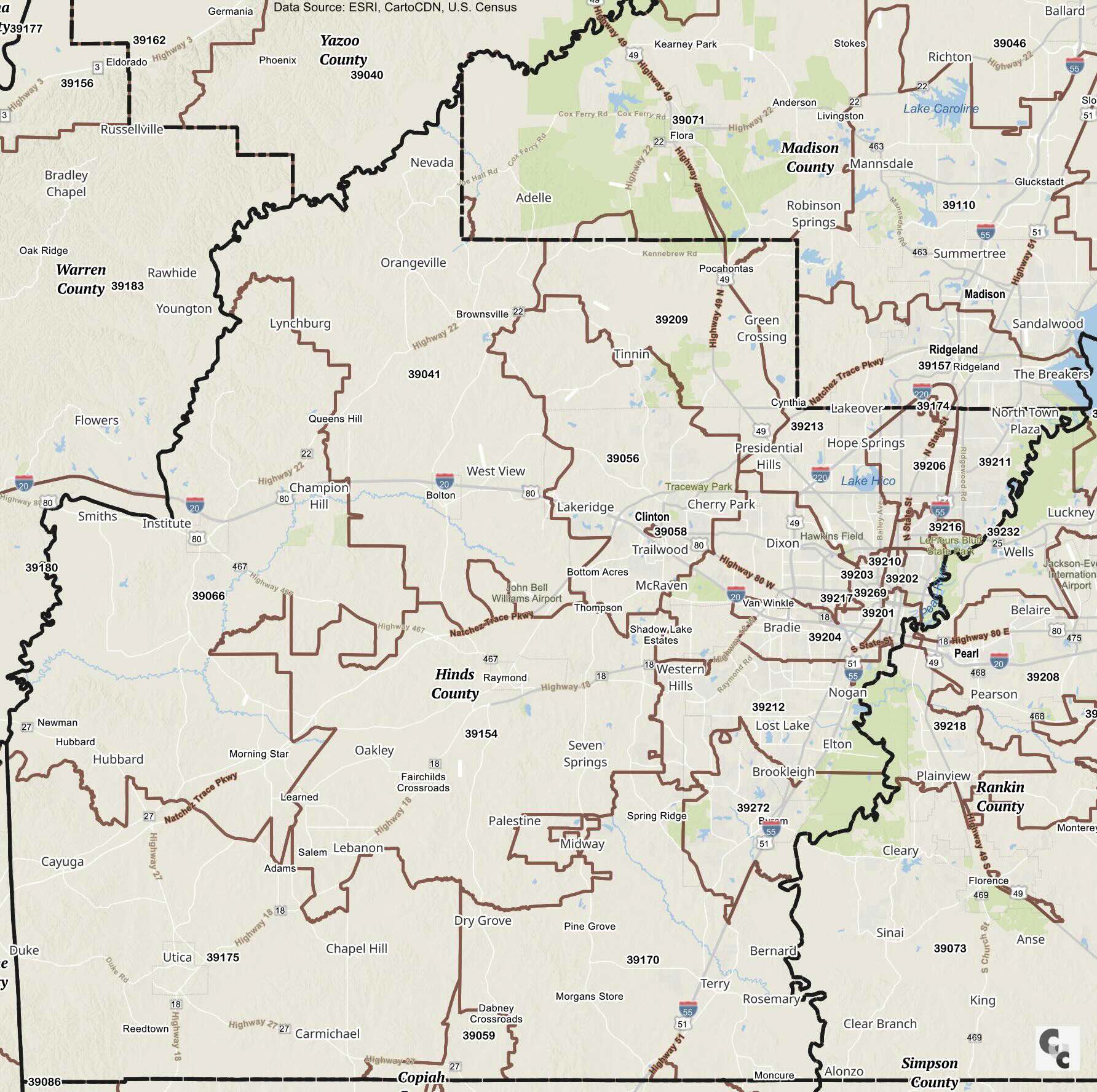
ZIP Code Tabulation Areas (ZCTAs) are generalized area representations of U.S. Postal Service ZIP codes, created by the Census Bureau to present demographic data aligned with postal areas. Unlike postal ZIP codes, which may change and include more complex boundaries, ZCTAs offer a stable geographic area for Census data reporting and analysis.
Hinds County, Mississippi, covers several ZIP codes across multiple towns and cities, including Jackson, Clinton, and Raymond. The ZIP codes in Hinds County range from the highest number, 392XX, to the lowest, 390XX. The county contains several Post Offices and PO boxes, serving both urban and rural residents.
Adams 39175 Zip Code Hinds County
Belaire 39211 Zip Code Hinds County
Bolton 39041 Zip Code Hinds County
Brownsville 39041 Zip Code Hinds County
Byram 39272 Zip Code Hinds County
Cayuga 39175 Zip Code Hinds County
Champion Hill 39066 Zip Code Hinds County
Chapel Hill 39175 Zip Code Hinds County
Cherry Park 39212 Zip Code Hinds County
Clinton 39056 Zip Code Hinds County
Cynthia 39213 Zip Code Hinds County
Dixon 39209 Zip Code Hinds County
Dry Grove 39170 Zip Code Hinds County
Edwards 39066 Zip Code Hinds County
Elton 39272 Zip Code Hinds County
Fairchilds 39154 Zip Code Hinds County
Hubbard 39154 Zip Code Hinds County
Lakeover 39213 Zip Code Hinds County
Learned 39154 Zip Code Hinds County
Lebanon 39154 Zip Code Hinds County
McRaven 39056 Zip Code Hinds County
Midway 39154 Zip Code Hinds County
Morning Star 39154 Zip Code Hinds County
Newman 39154 Zip Code Hinds County
Oakley 39154 Zip Code Hinds County
Palestine 39154 Zip Code Hinds County
Pocahontas 39071 Zip Code Hinds County
Raymond 39154 Zip Code Hinds County
Reedtown 39175 Zip Code Hinds County
Salem 39175 Zip Code Hinds County
Seven Springs 39154 Zip Code Hinds County
Spring Ridge 39272 Zip Code Hinds County
Tinnin 39056 Zip Code Hinds County
Trailwood 39056 Zip Code Hinds County
Utica 39175 Zip Code Hinds County
Van Winkle 39212 Zip Code Hinds County
West View 39209 Zip Code Hinds County
Western Hills 39212 Zip Code Hinds County
Youngton 39041 Zip Code Hinds County
Jackson 39201 Zip Code Hinds County
Jackson 39202 Zip Code Hinds County
Jackson 39203 Zip Code Hinds County
Jackson 39204 Zip Code Hinds County
Jackson 39206 Zip Code Hinds County
Jackson 39209 Zip Code Hinds County
Jackson 39211 Zip Code Hinds County
Jackson 39212 Zip Code Hinds County
Jackson 39213 Zip Code Hinds County
Jackson 39216 Zip Code Hinds County
Jackson 39217 Zip Code Hinds County
Jackson 39232 Zip Code Hinds County
Copyright CCCarto.com 2026