Glaciers of the Pacific Northwest Map — Washington & Oregon
The Pacific Northwest contains the largest concentration of glaciers in the contiguous United States. Most are located in the Cascade Range, particularly in the North Cascades and on major volcanic peaks such as Mount Rainier, Mount Baker, Mount Adams, Glacier Peak, Mount Hood, and Mount Jefferson. Since the mid-20th century, the majority of these glaciers have experienced significant retreat, thinning, and fragmentation due to rising temperatures, declining snowpack, and longer melt seasons.
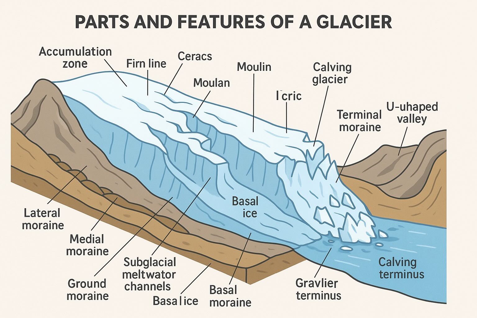
- Volcanic cone glaciers: Thick radial glaciers on stratovolcanoes like Mount Rainier and Mount Hood.
- Valley glaciers: Long tongues flowing down alpine valleys, common in the North Cascades.
- Cirque glaciers: Small glaciers occupying shaded mountain amphitheaters.
- Debris-covered remnants: Stagnant ice bodies transitioning into rock glaciers.
How to Identify Former Glacier Extent in the Cascades
- Moraines: Boulder ridges marking Little Ice Age and 20th-century ice margins.
- Trimlines: Vegetation and rock color boundaries showing past ice thickness.
- Proglacial lakes: Newly formed lakes at retreating glacier fronts.
- U-shaped valleys: Classic glacially carved terrain.
- Outwash plains: Braided meltwater channels below glacier termini.
Retreat Timeline in the Pacific Northwest
Most Cascade glaciers reached their maximum extent during the Little Ice Age (circa 1600–1850). Rapid retreat began in the early 20th century, accelerated after the 1980s, and intensified after 2000. Studies indicate that some North Cascade glaciers have lost 30–70% of their volume since 1900. On Mount Hood, several glaciers have fragmented into smaller ice bodies, while Mount Rainier’s glaciers continue to thin despite its high snowfall.
Impacts of Glacier Loss in Washington and Oregon
- Water supply: Reduced late-summer meltwater affecting rivers such as the Skagit, Nisqually, and Hood.
- Ecosystems: Warmer stream temperatures impacting salmon habitats.
- Hazards: Increased risk of debris flows, outburst floods, and unstable slopes.
- Landscape change: Rapid formation of lakes, new valleys, and exposed volcanic terrain.
- Tourism & recreation: Changing mountaineering routes and glacier travel conditions.