Peru’s Vanishing Glaciers Map: A Guide to Andean Ice Retreat
Peru is home to over 70% of the world’s tropical glaciers, but these vital water sources are disappearing at an alarming rate. Since the late 20th century, iconic peaks like Huascarán and Alpamayo have seen massive ice loss due to rising temperatures.
Types of Glaciers in the Peruvian Andes
Historically, Peru contained one of the largest concentrations of tropical glaciers on Earth, spanning the Cordillera Blanca, Cordillera Vilcanota, and Cordillera Huayhuash.
Today, the landscape is shifting toward small cirque and valley glaciers, many of which have fragmented into isolated ice patches.
Cirque glaciers: Small ice bodies in shaded amphitheaters; many are now perennial snowfields.
Valley glaciers: Shrinking ice tongues retreating rapidly toward high ridges (>5,000m).
Rock glaciers: Debris-covered ice bodies that become more prominent as "clean" ice melts.
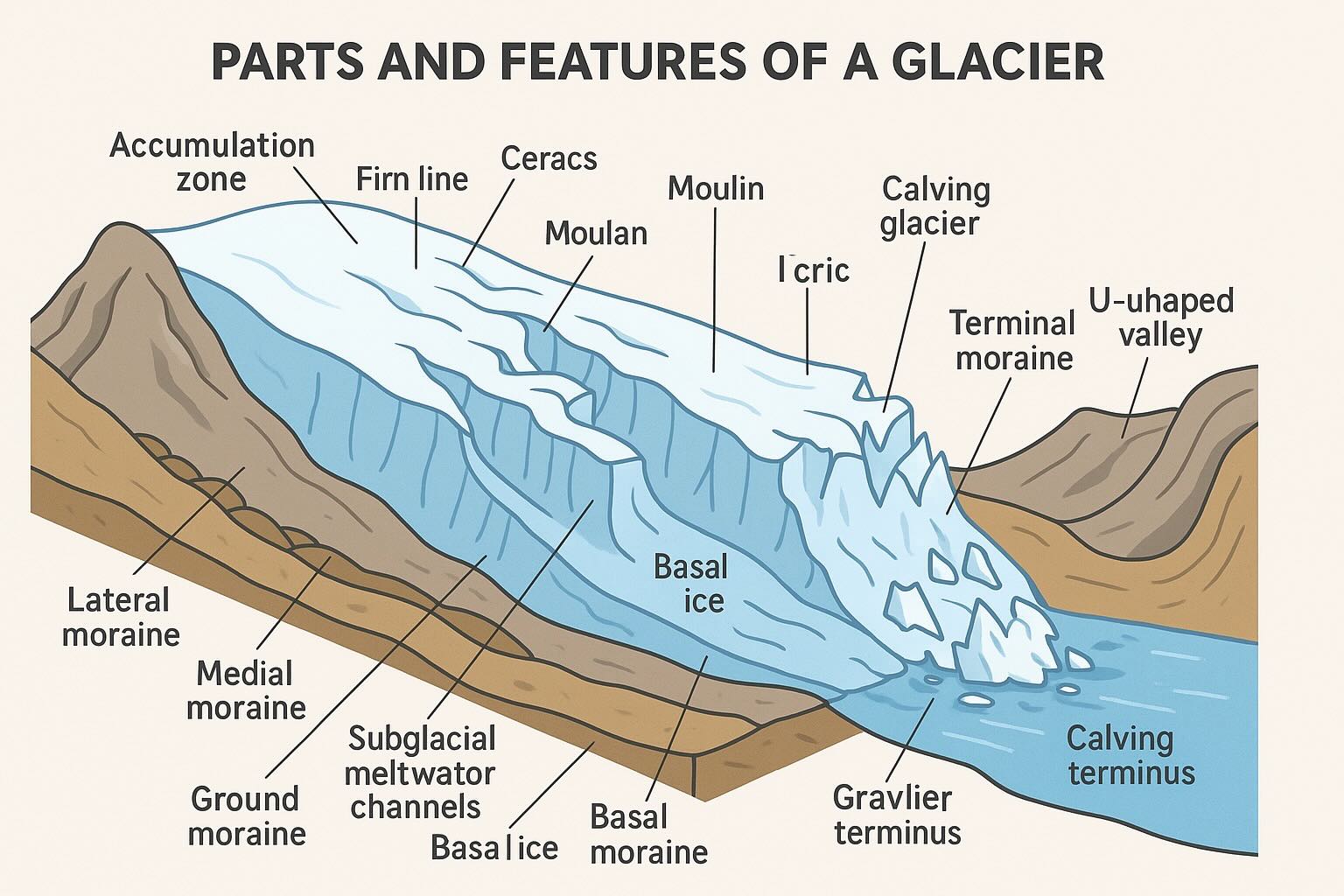
Common features of Andean glacial landscapes.
How to Recognize Former Glacier Limits
To understand the extent of recent retreat, look for these geomorphological markers:
Moraines: Ridges of debris marking past ice margins from the Little Ice Age.
Trimlines: Visible boundaries on valley walls showing where ice once scoured away vegetation.
Proglacial Lakes: Rapidly expanding water bodies dammed by unstable moraines.
Glacial Striations: Scratches on bedrock indicating the direction of past ice flow.
The Changing Structure of Peruvian Glaciers
As temperatures rise, the fundamental anatomy of Andean glaciers is changing. The most critical shift is the rise of the Equilibrium-Line Altitude (ELA), which determines the boundary between where a glacier gains and loses mass.
Accumulation vs. Ablation: Many tropical glaciers have lost their "accumulation zones" entirely, meaning they no longer have a way to regain mass from seasonal snowfall.
Fragmentation: Once-mighty valley glaciers are splitting into isolated "rock glaciers" and ice patches, which melt faster due to increased surface area exposure.
Decreased Albedo: As clean ice vanishes, the remaining surface becomes darker (debris-covered), absorbing more heat and accelerating the melt.
Retreat Timeline: A Rapid Decline
Key Fact: Since 1962, Peru has lost approximately 56% of its total glacier mass. In the Cordillera Blanca alone, the reduction is nearly 44% since 1984.
The retreat has accelerated significantly since the 1990s. High-profile sites like the Pastoruri Glacier and the Quelccaya Ice Cap (the world’s largest tropical ice body) serve as "climate sentinels," showing thinning rates that suggest many low-elevation glaciers will be gone by mid-century.
Socio-Economic Impacts of Glacial Loss
The disappearance of these "water towers" creates a ripple effect across the Peruvian economy and safety landscape:
Impact Area
Consequence
Water Security
Reduced dry-season flow for cities like Huaraz and Cusco.
Natural Hazards
Increased risk of GLOFs (Glacial Lake Outburst Floods).
Agriculture
Stress on bofedales (high-altitude wetlands) and pastoral lands.
GLIMS Data Dictionary Key
The following table defines the metadata fields associated with each glacier record in the Chile's Melting Glaciers atlas.
Click to expand technical glacier dataset fields
Field Name
Definition
glac_id
The GLIMS Glacier ID; a unique identifier generated from the longitude and latitude of the glacier centroid.
line_type
The category of the line segment. For glacier perimeters, this is glac_bound (glacier boundary).
area
The surface area of the glacier in km², as provided by the original analyst.
db_area
The surface area of the glacier in km², re-calculated within the GLIMS PostGIS database for consistency.
width
The representative width of the glacier in meters.
length
The representative length of the glacier in meters.
src_date
The timestamp or date of the source data (e.g., the date a satellite image was acquired).
glac_name
The official name of the glacier. Records labeled S/N indicate "Sin Nombre" (Unnamed).
wgms_id
The ID assigned by the World Glacier Monitoring Service, if applicable.
local_id
The identifier assigned by the local Regional Center or contributing institution.
glac_stat
Current status of the glacier record (e.g., exists).
proc_desc
A description of the processing steps, such as "Semi-automated band ratio" or "Manual editing."
geog_area
The name of the broader geographic region covered by the submission.
chief_affl
The affiliation of the Chief of the Regional Center responsible for the analysis.
surge_type
Classification of surging behavior (e.g., 0 = no evidence, 1 = surge-type).
term_type
The type of terminus (e.g., land-terminating, marine-terminating).
CenLon / CenLat
The geographic coordinates (longitude and latitude) of the glacier's centroid.
Data Credits: GLIMS Consortium. (2005, updated 2022). Data analyzed by University of Zurich-Irchel (GlobGlacier project).