
California once supported dozens of alpine glaciers across the Sierra Nevada and Cascade ranges during the late Little Ice Age. Today, only a small number of true glaciers remain. Most have shrunk dramatically due to rising temperatures, declining snowpack, and longer summer melt seasons. The greatest concentration of active glaciers is found on Mount Shasta, while the most documented remnants persist along the high crest of the Sierra Nevada, including Yosemite, Kings Canyon, and the Palisades region of the eastern Sierra.
Recent glaciological research indicates that many of California’s remaining glaciers could disappear within the 21st century if current warming trends continue. In several cases, formerly active glaciers have transitioned into stagnant ice bodies or perennial snowfields, meaning they no longer flow and therefore no longer meet the strict scientific definition of a glacier.
The Sierra Nevada now contains only a handful of glaciers that still exhibit measurable ice movement. Palisade Glacier, located in the Palisades range near Bishop, is the largest active glacier in California outside Mount Shasta and one of the most studied in the state. Maclure Glacier, near Mount Lyell in Yosemite National Park, continues to show slow but detectable flow, although its area has declined sharply over the past century.
By contrast, Lyell Glacier, once Yosemite’s largest glacier, has lost active motion and is now classified as stagnant ice. Other small cirque glaciers, including Conness Glacier and Dana Glacier, persist in shaded alpine basins but have lost a significant portion of their volume since the early 1900s. Several historically named glaciers documented in early surveys— including Darwin and nearby ice bodies—are now considered relict ice or have vanished entirely.
Mount Shasta hosts the most extensive glacier system in California and remains the state’s primary stronghold of active alpine ice. Seven named glaciers—Whitney, Hotlum, Bolam, Wintun, Konwakiton, Watkins, and Mud Creek—continue to flow on the mountain’s flanks. Despite their relative resilience, long-term measurements show persistent thinning, retreat of glacier termini, and increased melt during prolonged droughts and heat waves.
Because of its high elevation, volcanic topography, and heavy winter snowfall, Mount Shasta has retained glaciers longer than the Sierra Nevada. However, even Shasta’s glaciers are undergoing measurable mass loss, reflecting broader climate trends across the western United States.
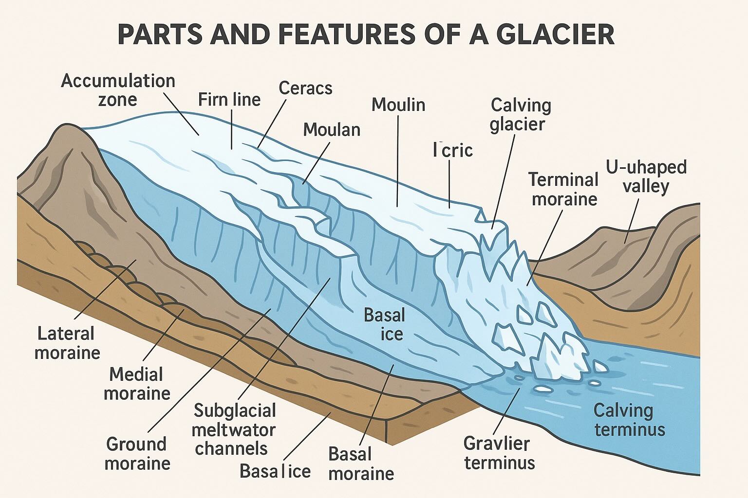
Most modern California glaciers are cirque glaciers, occupying bowl-shaped basins carved by past ice during the Pleistocene. A smaller number are short valley glaciers that extend downslope from high accumulation zones. Large ice fields, continental ice sheets, and tidewater glaciers do not exist in California’s present climate.
In many locations, former glaciers have transitioned into debris-covered ice, rock glaciers, or persistent snowfields. These features preserve evidence of past glaciation but lack the sustained flow required to be classified as active glaciers.
Note: In modern glaciology, an “active glacier” is defined as an ice body that exhibits measurable flow. Very small snowfields and stagnant ice masses are not included in current glacier inventories.
Information on California’s glaciers is derived from National Park Service monitoring programs, U.S. Geological Survey inventories, and peer-reviewed research in climate science and glaciology. Together, these sources document a century-long trend of glacier retreat, thinning, and fragmentation across the Sierra Nevada and Mount Shasta.
The following table defines the metadata fields associated with each glacier record in the Chile's Melting Glaciers atlas.
| Field Name | Definition |
|---|---|
glac_id | The GLIMS Glacier ID; a unique identifier generated from the longitude and latitude of the glacier centroid. |
line_type | The category of the line segment. For glacier perimeters, this is glac_bound (glacier boundary). |
area | The surface area of the glacier in km², as provided by the original analyst. |
db_area | The surface area of the glacier in km², re-calculated within the GLIMS PostGIS database for consistency. |
width | The representative width of the glacier in meters. |
length | The representative length of the glacier in meters. |
src_date | The timestamp or date of the source data (e.g., the date a satellite image was acquired). |
glac_name | The official name of the glacier. Records labeled S/N indicate "Sin Nombre" (Unnamed). |
wgms_id | The ID assigned by the World Glacier Monitoring Service, if applicable. |
local_id | The identifier assigned by the local Regional Center or contributing institution. |
glac_stat | Current status of the glacier record (e.g., exists). |
proc_desc | A description of the processing steps, such as "Semi-automated band ratio" or "Manual editing." |
geog_area | The name of the broader geographic region covered by the submission. |
chief_affl | The affiliation of the Chief of the Regional Center responsible for the analysis. |
surge_type | Classification of surging behavior (e.g., 0 = no evidence, 1 = surge-type). |
term_type | The type of terminus (e.g., land-terminating, marine-terminating). |
CenLon / CenLat | The geographic coordinates (longitude and latitude) of the glacier's centroid. |
Source: World Glacier Inventory
Map Copyright CCCARTO 2026