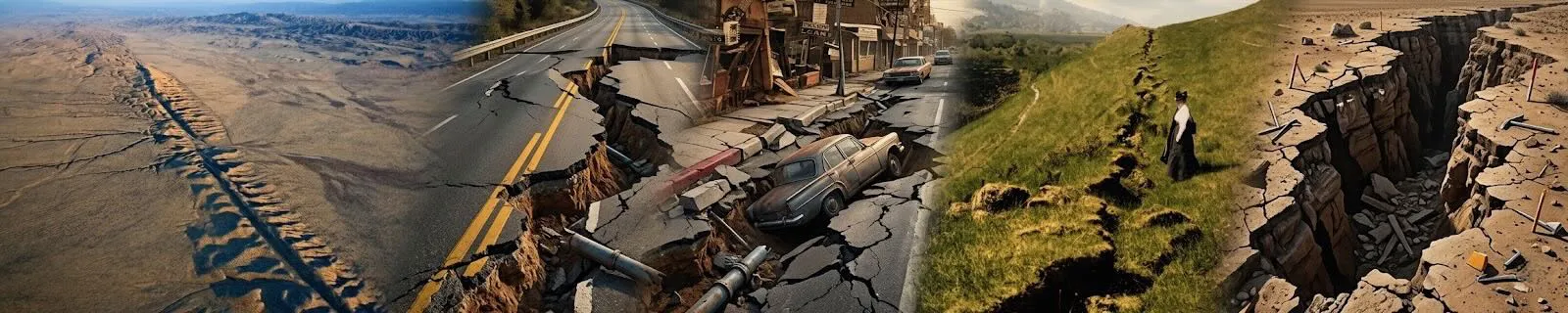
Los Angeles Earthquake Faults Map
View earthquakes for the last 30 days
The above map shows fault zones in the Los Angeles Basin region. Click on faults for more information.
Major Earthquake Faults in the Los Angeles Basin
1. San Andreas Fault: The most famous fault in California, though it lies just outside the Los Angeles Basin, its influence on seismic activity is significant.
2. Newport-Inglewood Fault: Runs through the heart of the Los Angeles Basin, responsible for several significant earthquakes, including the 1933 Long Beach earthquake.
3. Whittier Fault: An active fault on the northeastern edge of the basin.
4. Santa Monica Fault: A smaller but active fault that could produce significant seismic events.
5. Sierra Madre Fault: Runs along the base of the San Gabriel Mountains, capable of producing strong earthquakes.
6. Hollywood Fault: A fault running under Hollywood, capable of significant seismic events.
7. Raymond Fault: Located in the San Gabriel Valley, part of the larger San Andreas Fault system.
8. Puente Hills Blind Thrust Fault: A dangerous fault because of its location beneath downtown Los Angeles and surrounding areas, discovered relatively recently.
Los Angeles' Most Active Faults in the Last Fifty Years
- Northridge Blind Thrust Fault: Responsible for the 1994 Northridge earthquake, one of the most destructive in the region's history.
- Newport-Inglewood Fault: While not causing a major event in the last fifty years, it remains a overdue concern due to its location.
- Whittier Fault: The 1987 Whittier Narrows earthquake was a significant event in recent history.
Biggest Earthquakes in Property and Financial Damage
- 1994 Northridge Earthquake: Magnitude 6.7, caused over $44 billion in damage (equivalent to about $77 billion today), making it the costliest earthquake in U.S. history at the time.
- 1971 San Fernando Earthquake: Magnitude 6.6, caused about $505 million in damage (approximately $3.5 billion today).
Oldest and Biggest Los Angeles Faults
- San Andreas Fault: The San Andreas Fault system is one of the oldest and largest in California.
- Sierra Madre Fault: Also among the older fault systems in the region, responsible for uplifting the San Gabriel Mountains.
Newest LA Faults Discovered in the Last Fifty Years
- Puente Hills Blind Thrust Fault: Discovered in the late 20th century, it’s considered one of the more dangerous faults due to its location beneath a densely populated area.
- Northridge Blind Thrust Fault: Discovered after the 1994 earthquake it caused.
Leading Researchers and Institutions
Dr. Lucy Jones: A leading seismologist who has been influential in earthquake research in the Los Angeles area.
Caltech (California Institute of Technology): One of the primary research centers for seismology in Los Angeles.
UCLA (University of California, Los Angeles): Also conducts significant research on seismic activity and earthquake faults.
SCEC (Southern California Earthquake Center): A research center that focuses on earthquake hazard in Southern California, with many researchers contributing to the understanding of faults in the Los Angeles Basin.
Leading Countries in Earthquake Research Funding
Several countries are prominent in funding research and researchers on earthquakes. Here are some of the leading ones:
1. United States: The United States, through agencies like the National Science Foundation (NSF), the United States Geological Survey (USGS), and various university research programs, invests heavily in earthquake research.
2. Japan: Japan, due to its high seismic activity, invests significantly in earthquake research through organizations like the Japan Agency for Marine-Earth Science and Technology (JAMSTEC) and the Japan Meteorological Agency (JMA).
3. China: China has made substantial investments in earthquake research through agencies like the China Earthquake Administration (CEA) and various universities.
4. New Zealand: New Zealand, another seismically active country, funds earthquake research primarily through the Earthquake Commission (EQC) and the GNS Science research institute.
5. European Union: The EU provides funding through programs like Horizon Europe and the European Research Council (ERC), supporting earthquake research across member states.
6. Italy: Italy, known for its seismic hazards, funds research through the National Institute of Geophysics and Volcanology (INGV) and university programs.
7. Canada: Canada funds earthquake research through agencies like Natural Resources Canada (NRCAN) and universities across the country.
These countries are not only prone to earthquakes but also actively contribute to global earthquake research initiatives, fostering international collaboration and advancing seismic hazard mitigation strategies.
Major Movies About Los Angeles Earthquakes
1. "San Francisco" (1936)
- Actors: Clark Gable, Jeanette MacDonald, Spencer Tracy
- Plot: Fictionalized account of the 1906 San Francisco earthquake.
2. "Earthquake" (1974)
- Actors: Charlton Heston, Ava Gardner, George Kennedy, Lorne Greene
- Plot: A catastrophic earthquake hits Los Angeles, causing widespread destruction.
3. "Aftershock: Earthquake in New York" (1999)
- Actors: Tom Skerritt, Sharon Lawrence, Charles S. Dutton
- Plot: A TV miniseries about a major earthquake hitting New York City, though not directly related to Los Angeles.
4. "10.5" (2004)
- Actors: Kim Delaney, Fred Ward, Ivan Sergei
- Plot: A TV miniseries about a massive earthquake splitting the West Coast from the rest of the U.S.
5. "San Andreas" (2015)
- Actors: Dwayne Johnson, Carla Gugino, Alexandra Daddario
- Plot: A massive earthquake hits California, with scenes set in Los Angeles.
Schools and Research Centers on Earthquake Faults
- Caltech: Leads in seismology research, especially in the Los Angeles region.
- UCLA: Another significant center for earthquake research.
- USC (University of Southern California): Engages in interdisciplinary research on seismic hazards, often collaborating with USGS and other institutions.
Significant Earthquakes in California
California has experienced several significant earthquakes since man has been here. Some of the largest earthquakes include:
1. San Francisco Earthquake (1906): This was one of the most devastating earthquakes in U.S. history, with an estimated magnitude of around 7.9.
2. Fort Tejon Earthquake (1857): This earthquake had an estimated magnitude of about 7.9 and ruptured the southern part of the San Andreas Fault.
3. Northridge Earthquake (1994): This earthquake, with a magnitude of 6.7, caused significant damage in the Los Angeles area.
Likelihood of a Large Earthquake in Los Angeles
Regarding the likelihood of a large earthquake hitting Los Angeles, it's important to note that earthquake prediction is challenging, and earthquakes do not occur on a strict schedule. However, Los Angeles sits near the San Andreas Fault and experiences frequent seismic activity. The region is considered to be at risk for earthquakes of magnitude 7.0 or greater.
Seismologists typically discuss earthquake probabilities in terms of statistical averages rather than specific predictions. The "overdue" concept for earthquakes can be misleading because it implies a regularity in earthquake occurrence that doesn't exist. Earthquakes are governed by complex geological processes that are not easily predictable on a short-term basis.
To summarize, while Los Angeles and California are prone to significant earthquakes, the exact timing and magnitude of future earthquakes cannot be accurately predicted. It's important for residents to be prepared and follow building codes and earthquake safety guidelines.
The San Andreas Fault has produced some of the largest earthquakes in California's history. The largest estimated magnitude earthquake on the San Andreas Fault in the past few thousand years is believed to be around magnitude 8.2 to 8.3.
Regarding historic tidal waves (tsunamis) in California over the centuries, there is evidence of tsunamis affecting the coast, likely triggered by offshore earthquakes or landslides. One notable event occurred around 300-500 years ago, leaving geological evidence along the California coast.
Local Native American tribes in California had various names for earthquakes. For example, the Chumash people referred to earthquakes as "qhaqhaqtal," and the Pomo people called them "ekemu." These names often reflected cultural interpretations of these natural events.
Native American beliefs about earthquakes varied among tribes. Some viewed earthquakes as natural phenomena governed by spirits or as signs from their gods, while others saw them as part of the natural order of the world.
Effects of Earthquakes
Earthquakes can indeed lead to a variety of unusual phenomena and effects across different domains:
1. Water Bodies:
- Tsunamis: Earthquakes under the ocean floor can trigger tsunamis, massive waves that can travel great distances and cause extensive coastal damage.
2. Land:
- Liquefaction: where saturated soil temporarily loses strength during strong shaking, has been observed during past large earthquakes in Southern California. This phenomenon occurred notably during the 1906 San Francisco earthquake and the 1994 Northridge earthquake, affecting areas with loose, water-saturated soils.
3. Electricity:
- Power Outages: Earthquakes can damage power lines, transformers, and substations, leading to widespread power outages.
4. Plants:
- Changes in Water Table: Seismic waves can affect groundwater levels, impacting plant roots and hydration.
5. Animals:
- Behavioral Changes: Animals may sense an earthquake's vibrations before humans, leading to changes in their behavior, such as seeking shelter or becoming agitated.
6. People:
- Injuries and Structural Damage: People can suffer injuries from collapsing buildings, falling debris, or tripping during the shaking.
- Psychological Impact: Earthquakes can cause fear, anxiety, and trauma in affected populations.
These effects can vary widely based on the magnitude, depth, and proximity of the earthquake to populated areas and natural environments.
There are several misconceptions and myths about earthquakes that people often believe. Some of these myths persist due to a lack of understanding about the science behind earthquakes or because of exaggerated stories passed down over time. Here are some of the most common ones:
1. "Earthquakes only happen in certain places."
- Myth: Many people believe that earthquakes only occur in certain regions, like California or Japan.
- Reality: Earthquakes can happen almost anywhere in the world, though they are more frequent in certain areas due to tectonic plate boundaries. Places not typically associated with earthquakes can still experience significant seismic activity.
2. "During an earthquake, you should stand in a doorway."
- Myth: A long-standing belief is that doorways are the safest place to be during an earthquake.
- Reality: This advice is outdated. In modern buildings, doorways are not necessarily stronger than other parts of the building. It's safer to drop, cover, and hold on under sturdy furniture, such as a table, to protect yourself from falling debris.
3. "Small earthquakes prevent larger ones."
- Myth: Some believe that frequent small earthquakes release pressure and prevent larger earthquakes.
- Reality: While small earthquakes do release some seismic energy, they are not enough to prevent a larger earthquake. A significant earthquake occurs due to the buildup and sudden release of a substantial amount of energy, which smaller quakes cannot fully alleviate.
4. "The ground can open up and swallow people during an earthquake."
- Myth: Movies and stories often depict the ground splitting open and swallowing people or buildings.
- Reality: This is highly unlikely. The ground may crack during an earthquake, but it does not open up to swallow things. Most earthquake damage is due to ground shaking and the resulting collapse of structures.
5. "Animals can predict earthquakes."
- Myth: Some people believe that animals can sense an earthquake before it happens and act strangely as a result.
- Reality: While animals might react to the initial, less noticeable seismic waves (P-waves) before humans do, there is no scientific evidence that they can predict earthquakes before these waves occur.
6. "You should run outside during an earthquake."
- Myth: Many believe that the best response to an earthquake is to immediately run outside to avoid getting trapped inside a collapsing building.
- Reality: Running outside can be dangerous. Falling debris, glass, and other hazards pose significant risks. It's generally safer to stay inside and take cover under sturdy furniture until the shaking stops.
7. "Earthquakes are more common in certain weather conditions."
- Myth: Some people think that earthquakes are more likely to happen during specific weather, like hot, dry, or stormy conditions.
- Reality: Weather does not influence earthquake activity. Earthquakes are caused by tectonic forces deep within the Earth's crust, far below where weather changes occur.
8. "Big earthquakes can be predicted."
- Myth: There's a belief that with the right technology, large earthquakes can be predicted days or weeks in advance.
- Reality: Despite advances in technology, scientists cannot predict exactly when and where a major earthquake will occur. They can only estimate the probability of an earthquake happening in a particular area over a certain period.
9. "Aftershocks are always smaller than the main earthquake."
- Myth: It's commonly believed that aftershocks are always weaker than the initial earthquake.
- Reality: Aftershocks are typically smaller, but they can sometimes be as large as or even larger than the original earthquake. These secondary quakes can cause significant additional damage.
10. "The safest place to be during an earthquake is outside."
- Myth: Some people believe that being outside during an earthquake is safer than being indoors.
- Reality: This depends on the situation. If you're already outside, you should move away from buildings, trees, and power lines that could fall. If you’re indoors, it’s usually safer to stay inside and find cover until the shaking stops.
Understanding these myths and the facts about earthquakes can help people be better prepared and respond more effectively when one occurs.
Building a comprehensive earthquake kit is crucial for preparedness. Here's a list of essential items you should consider:
1. Water: One gallon per person per day for at least three days, for drinking and sanitation.
2. Food: Non-perishable items for at least three days, such as canned goods, protein bars, and freeze-dried meals.
3. First Aid Kit: Including bandages, antiseptic wipes, pain relievers, and any necessary medications.
4. Flashlight and Extra Batteries: For lighting in case of power outages.
5. Whistle: To signal for help.
6. Dust Masks: To filter contaminated air and debris.
7. Plastic Sheeting and Duct Tape: For shelter and repairs.
8. Wrench or Pliers: To turn off utilities like gas or water.
9. Can Opener: If your food supplies are in cans.
10. Local Maps: To navigate if GPS or phone networks are down.
11. Cell Phone with Charger: Preferably a portable power bank or portable solar panel.
12. Extra Clothing and Sturdy Shoes: For warmth and protection.
13. Personal Hygiene Items: Including moist towelettes, garbage bags, and toilet paper.
14. Cash: In small denominations and coins.
15. Important Documents: Copies of identification, insurance policies, and other essential papers.
Note: you can use chlorine and heavy metals removal tablets to make pool water safer to drink in an emergency. However, follow the directions for safety.
Fault Maps of LA County:
San Andreas Fault Mojave Section Map

Garlock Fault Map

Sierra Madre Zone Fault Map

Whittier Fault Map

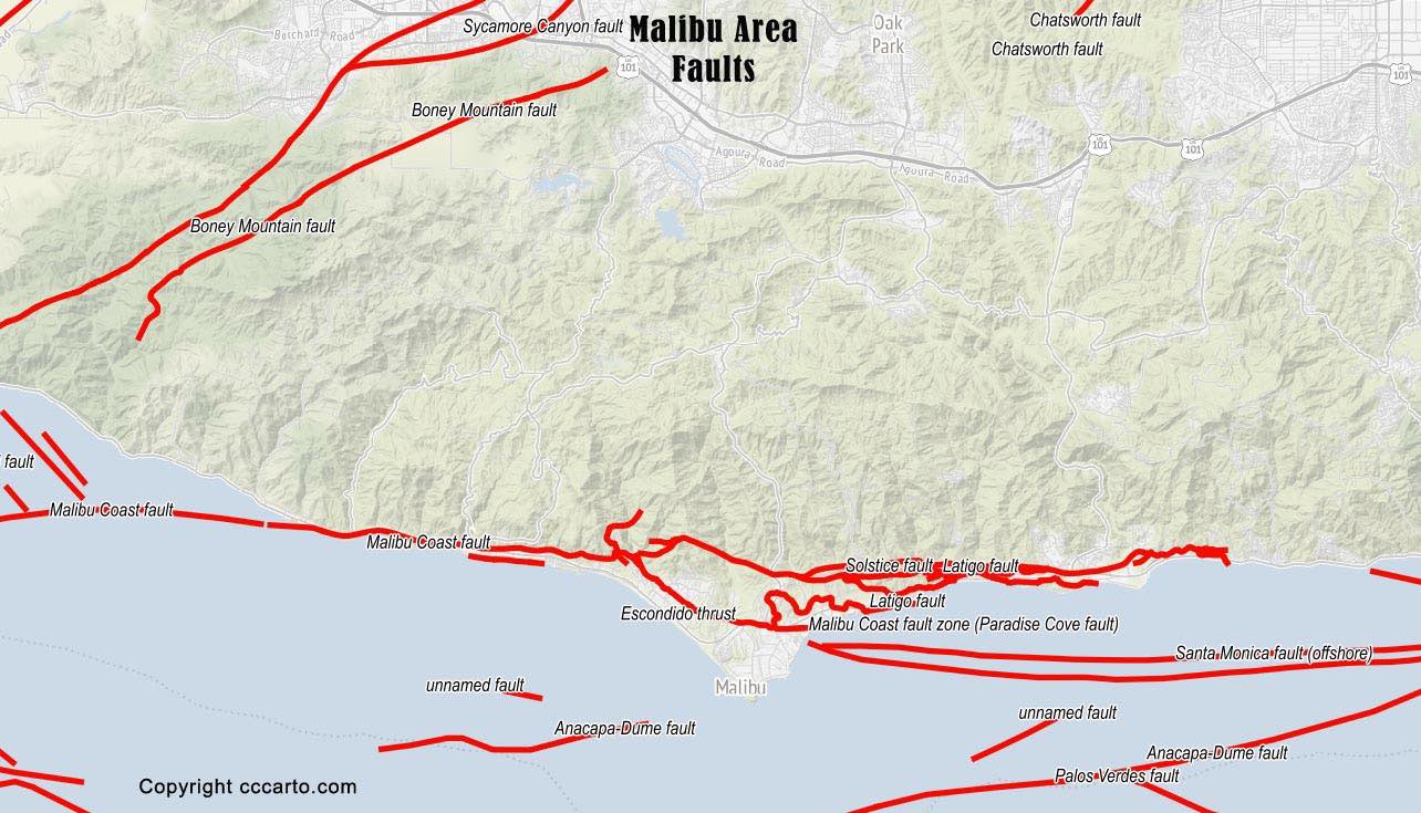
Malibu Area Fault Map
Raymond Fault Map

San Fernando Valley Fault Map

Santa Monica Area Faults

San Andreas Carrizo Plain Fault Map

Palos Verdes Area Fault Map

Newport-Inglewood Fault Map

Things to check or prepare before an earthquake:
1. Check your earthquake insurance policy. Property and valuables have gone way up in value to replace. Make sure you have
enough earthquake insurance coverage.
2. Make sure you have a wrench near your gas and water valves. Many companies sell aluminum wrenches
that don't weather and can be placed outdoors next to your gas valve.
3. Do a check of things that would most likely fall in an earthquake. Anything top-heavy with a high
center of gravity will most likely fall over. Move these items to lower shelves or fasten them down with
metal straps, cleats, or screws. These include tall and thin HDTVs, bookcases, old
water heaters, things that are high on bookshelves like trophies, and large and heavy pictures placed high.
Earthquake-proofing latches on cabinets that can hold a lot of glass and china would be a good idea. The best
earthquake latches are specially designed. (Hafele Earthquake Pressure Catch). They work very well. Along with QuakeHold wax and putty for items on shelves.
4. Your garage is a dangerous place during an earthquake. Many garages have things placed in the rafters that can
fall. Also, a lot of flammable things like paint thinners and solvents in coffee cans are left on garage workbenches with
their lids ajar or open. You should secure these items so they won't spill and cause a fire. Remember, in a
large earthquake most water mains will be broken and water won't be available after a quake.
5. Throw an old pair of tennis shoes in your car. You might have to walk home after a quake. Tennis shoes
are better to walk in than dress shoes.
6. Check your house, driveway, and garage for objects that could fall down and destroy your car. These
include chimneys, unreinforced walls, tall items, power poles/lines, etc.
7. Keep some water on hand for drinking. A few gallons for each person will keep you alive for a couple of
days before the State/Feds can get bottled water in.
8. Keep a radio on hand and flashlights in each room.
9. Make an earthquake kit. A new trash can with a lid is a good watertight place to store items. Things to store in it
would be tools, freeze-dried meals, water bottles, cutlery, matches, enough food for your pets for a few days, toilet
paper, survival manual, work gloves, soap, first aid kit, clothes, blanket, portable radio, wrench, screwdriver, hammer, money, and anything else you would need for the first 48-72 hours. Some people even buy
generators and store them in the garage for emergencies. They can keep their refrigerators, tools, and lights
running if power is out for a week or more.
10. Other good items to get before a large earthquake hits include: crank recharging lantern, a LifeStraw® for purifying pool and other water, candles, a Leatherman or Swiss Army multi-tool knife, LED flashlight, crank/solar charger for your smartphone, and a fire extinguisher.
Things to check after a quake -
1. Check family members/pets in house. If in house, call out and don't walk to them. Broken glass and items blocking
your way will be all over the house floors.
2. If it is night. Find your flashlight and shoes first before walking around. Make sure you are not in danger
before getting up. Items may have fallen in the house that could cause a threat. Example: If your house
has a large aquarium, it might have now fallen over and flooded the house causing a shock danger.
3. If the quake was large, check for damage. Check for gas smell first and shut off main valve
if you smell gas. Check for things that are partially fallen and secure them. There will most likely be
aftershocks that will complete the task of dislodging them.
4. Be very careful opening up cabinets and your refrigerator. Many items will be broken and loose and will
fall out on you.
5. Unplug items that have fallen - TVs, stereos, microwaves, computers; etc.
6. Check for structure damage. Walls, door frames, cracks, chimneys, pool, windows, car, gas, water,
electric, phone. If your windows are cracked, you might want to tape them with duct tape to keep glass
from flying in a aftershock. If they are broken, knock out any loose glass.
7. After a large quake most cellphone and landline service will be out. Listen to a portable or car radio
for information if TV and power are out.
8. If water is still on after a quake you might want to fill water bottles and tub for water. Most
likely water mains will have broken and you will lose pressure fast.
9. Check for anything that has fallen outside. This includes power-lines and hazardous structures.
10. Check neighbors and see if they are ok. If they are not home turn off their gas. The number one
threat after a quake are fires. Most water mains will be broken and no water will be available to fight
fires. If a house near yours catches on fire, it will spread.
11. Keep freezer and refrig closed. Power will be off and items will last longer if you don't open the
doors much.
12. Check your water heater and toilets. Don't use or flush them. If the water mains are broken you can
use the water in the water heater and toilet reservoir tank until they get water trucked into your area and
the mains get fixed. Pool and spa water can be used for washing water if you have access to them.
Fault Attributes Key
NAME is an 80-character field for the name of the fault (including section name,
i.e., Denali fault, Holitna section). Fault and section are lower case.
CODE is a three-integer field.that defines certainty or reliability of field mapping
(integer one), time of most recent movement (integer two), and amount or rate of slip (integer three).
CODE is composite of the single integer fields ACODE, SLIPCODE, and FCODE
and determines the line type (fault trace) to be plotted.
NUM is a six-character unique USGS identifier that defines a fault or section id. Simple fault
ids are only numeric; section ids are alpha numeric.
AGE is the upper bounding time of the most recent surface-deforming earthquake. The allowable
choices are provided in a pull-down menu.
ACODE is the second integer in CODE and defines the upper bounding time of the most recent
surface-deforming earthquake.
Permissible values are between 1 and 6: 1=historic «150 years; red =cmyk 1096680);
2= post glacial (15,000 years; orange = cmyk 1 38 1000);
3 = late Quaternary «130,000 years; green> cmyk 1002500);
4 =middle and late Quaternary «750,000 years: blue > cmyk 1004440);
5 =Quaternary «1,600,000 years; black 5);
6 = Class B (black halftone)
In the text documentation, Quaternary faults (integer two, 1-5) are Class A structures. Questionable or
suspected structures are Class B (integer two, 6).
SLIPRATE is the assigned slip rate category.
SLIPCODE is the third integer in CODE and defines the assigned slip rate category. Permissible
values are between 1 and 4 and determines line width:
1=>5 mm/year (extra wide; .048):
2 =1-5 mm/year (wide; .0325):
3 =0.2-1 mm/year (medium; .025);
4 =<.2 mm/year (thin; .015)
SLIPSENSE is normal, reverse, strike slip, thrust
DIPDIRECTION is one of the eight quadrant dip directions for the entire fault or section, not the
individual arc. C = center E =east N_ =north NE =northeast NW =northwest S =south SE =southeast SW =
southwest W_ =west
SLIPDIRECT (we are not using that field anymore and can be left empty) FCODE is the first integer
in CODE and defines how well the fault is located and expressed in the landscape. Permissible values are
between 1 and 3:
1 = fault landforms are more continuous than discontinuous and mapping is accurate at
given MAPPEDSCALE (solid);
2 = fault landforms are more discontinuous than continuous and mapping is accurate at
given MAPPEDSCALE (dashed);
3 = location of fault is inferred (dotted)
FTYPE is one of three allowable choices provided in a pull-down menu: Well constrained (FCODE 1),
Moderately constrained (FCODE 2), and Inferred (FCODE 3)
MAPPEDSCALE is one of four allowable choices provided in a pull-down menu.
Mapped scale will control visualization of the fault at various scales.
1:24,000, fault should be more continuous than discontinuous and mapping is accurate at <10,000 scale.
1:50,000, fault should be more continuous than discontinuous and mapping is accurate at <25,000 scale.
1:100,000, fault could be more discontinuous than continuous and mapping is accurate at <50,000 scale.
1:250,000, fault location may be inferred or is poorly constrained.
Click on the fault lines for more information.
Note* The earthquake faults are color coded by unique name and section not type.
Data source: USGS
CCCarto is not responsible for data errors or omissions, use as reference only.
copyright cccarto.com
Other Earthquake Fault Maps:
Region Faults
Other Web Maps:
Main Web Map Index
CCCarto 2025